BeachNet Repeater System

District Three EOC Packet Network

Pacific, Grays Harbor, Lewis, Mason, Thurston & Wahkiakum Counties, Washington

145.170 |  145.310 |  145.390 |  147.020 |  147.180 |  147.340 |  224.040 |  224.820 |  440.675 |  441.675 |  442.675 |  444.050 |  444.200 |  444.400 |  444.500 |  444.700 |  444.800 |  444.925 |  444.950


Home
Frequencies

Coverage Map
More Info
Pictures
Technical Staff
Pacific County Link's


Packet Radio: For those unfamiliar with the term "Packet Radio", a brief description is "a digital radio technique that allows text messages to pass from one computer to another, using Amateur radio". In practice, this is very much like sending and receiving email, however the connection is made using Amateur radio, rather than conventional wired or wireless Internet connections. Most packet activity is on VHF, but there is significant activity on UHF and even HF. The range can therefore be anything from a few miles to several thousand miles, making it popular with "Hams" who enjoy "RV-ing" or cruising on boats, where a normal Internet connection may be scarce. Packet Radio uses virtual "connections", which may pass through a number of "Node" stations along the way. Although the Packet Radio network can, and does, interface with the Internet at a few locations, the radio portion is itself independent of the Internet. Packet Radio can move messages without any outside infrastructure. It can also move messages from an area that is without Internet service to an area where Internet service is available. Packet Radio is an important technique for those involved in EmComm.

District Three: Western Washington ARES/RACES District/Region Three comprises Pacific, Grays Harbor, Lewis, Mason and Thurston Counties. For geographical reasons, the Emergency Communication (EmComm) "EOC" Packet Radio Network also includes Wahkiakum County and the Washington State Emergency Coordination Center at Camp Murray. The primary frequency for the network is 145.630 MHz. This is simplex, of course, and does not use any CTCSS (PL) tones.

The packet network is not part of
BeachNet, however since many of the packet resources are co-located at our sites, and owned and/or maintained by Principles, Associates or Friends of this project, it seems appropriate to list a modicum of information on this website.

Maps: The following map shows the locations of the public resources that comprise the infrastructure available for "Packeteers" in our area. For more information, or to monitor or join the Yahoo discussion group devoted to this Packet Network, click here. This page is a quick summary intended for those who are either newcomers needing a few tips to get started exploring packet radio in our region, or old-timers who only need to look up a callsign or two. There is much more detailed material on the Yahoo Group site.

Maps are important, and the "Packeteer" who is serious about being able to operate in an EmComm situation would be well advised to keep paper copies up to date in the shack. During a disaster or emergency, some of the normal resources may not be available. One of the strengths of packet radio is that nearly any station in the network may be used as a digipeater or node, allowing the skilled (and informed) operator to work around "holes" in the network.


Station Type: Station Alias or Call: Other Callsign: Notes:
RMS KD7X-10 KD7X-10 Oak Harbor in northern Puget Sound
RMS K7WG-10 K7WG-10 Shelton, WA, Mason County
RMS K7GA-10 K7GA-10 Cathlamet, WA, Wahkiakum County
RMS AA7ZV-10 AA7ZV-10 Puyallup, WA
RMS AC7YY-10 AC7YY-10 Centralia, WA, Lewis County
RMS KF7DJC-10 KF7DJC-10 Centralia, WA, Lewis County
RMS K7IEU-10 K7IEU-10 Raymond, WA, Pacific County
RMS N7DRD-10 N7DRD-10 Ocean Park, WA, Pacific County
RMS W7EMD-10 W7EMD-10 Camp Murray, RMS only intermittently when necessary.
RMS IQICMS K7IQI RMS station in Portland West Hills, usually accessible from NICOLI Node.
Node ELYSSA K7IDX Covers Puget Sound from Mt. Jupiter at 3250-feet in the Olympic Mtns. over Hood Canal.
Node NEILTN W7EOC-8 Overlooks NW Grays Harbor County from 2100-feet near Lake Quinault
Node SMTN N7SK-7 South Mountain, Olympic foothills near Shelton in Mason County
Node HOLYX WA7PC-6 Near South Bend at 1200-feet on Holy Cross Mtn. in Pacific County
Node MINOT W7EOC-9 SE Grays Harbor County from 1800-feet near Elma
Node NICOLI K7GA-8 On Nicolai Mtn in Clatsop County, OR, 3000-feet 9-miles south of Westport, OR
Node VICTOR N7YGE-3 Mason County, multi-port node
Node BCFD W7TAI-1 Bay Center Fire Dept., Pacific Coun ty, K-Node at 100-feet. W7TAI-1=BBS
Bridge N7UJK-8
N7UJK-9
N7UJK-10 Bridge between 145.630 & 145.050; -8 digi on 145.63; -9 digi on 145.05; -10 digi bridge between the two frequencies, either direction. Capitol Peak, 3000-feet. (see below)
Bridge NM7R-8
NM7R-9
NM7R-10 Bridge between 145.630 & 144.960; -8 digi on 145.63; -9 digi on 144.96; -10 digi bridge between the two frequencies, either direction. Nahcotta, WA, 100-feet. (see below)
EOC W7EMD W7EMD Camp Murray, WA State ECC, station may be an Airmail Mailbox or Keyboard station
EOC MCDEM AA7CG Mason County EOC, MCDEM=BBS, AA7CG=keyboard
EOC WA7OLY WA7OLY Thurston County EOC
EOC W7EOC W7EOC-1 Grays Harbor County EOC, W7EOC-1=BBS, W7EOC=keyboard
EOC COCEOC COCBBS City of Centralia EOC, COCBBS=BBS, AC7YY-4=keyboard
EOC AC7SR-3 AC7SR-4 Lewis County EOC, AC7SR-4=BBS, AC7SR-3=keyboard
EOC WA7PC WA7PC-1 Pacific County EOC (South Bend), WA7PC-1=BBS, WA7PC=keyboard (main EOC)
EOC W7RDR W7RDR-1 Pacific County AEOC (Long Beach), W7RDR-1=BBS, W7RDR=keyboard (Auxiliary EOC)
BBS COCBBS COCBBS A full-service, forwarding Bulletin Board System, hosted by City of Centralia ARES

The stations in green on the map are Winlink2000 (WL2K) Remote Message Server (RMS) stations, which allow the sending of messages using Internet email for delivery at the other end. The reverse path is also available, from the Internet to packet radio. From an EmComm standpoint, this is a tremendous resource, especially out here at the "end of the extension cord", where we frequently loose power, telephone and Internet during winter storms, sometimes for days at a time. Being able to access an RMS station that still has Internet connectivity can allow message traffic to flow into and out of the affected area, quickly and efficiently.

The stations in blue on the map are Nodes. Most are simple K-Nodes. These allow access to the network from nearly anywhere in the region. There are usually several paths possible from one point to another, allowing recovery from the loss of one or more stations. This network is simple, but effective. Using the Nodes as necessary, any packet station in the Region should be able to connect with an RMS station to work traffic.

The stations in violet on the map are "Bridges". These two stations operate as digipeaters (not Nodes). You don't connect TO them, but THROUGH them, using the "via" command. In each case, the "-8" callsign works as a digipeater on the 145.63 network frequency, and the "-9" callsign operates as a digipeater on another frequency, used in an adjacent area. The "-10" callsign allows packets to flow between the two frequencies, still as a digipeater, in either direction. In the case of the N7UJK Bridge on Capitol Peak, near Olympia, the alternate frequency is 145.05, used by Puget Sound stations. To work these stations, all that is necessary from the 145.63 side is to issue the command, "C NOTAC V N7UJK-10", from a suitable location. Depending upon your station location, this may require first connecting to a Node close enough to access the Bridge. "NOTAC" is part of the Pierce County Hospital Services Net of Puget Sound, operating on 145.050.

Similarly, the NM7R Bridge works between 145.63 and 144.96, the frequency used in the Astoria, Oregon area. Sending the command, "C JAY V NM7R-10" from a suitable location will connect to the "JAY" Node on Wickiup Mtn., near Astoria. From there it is possible to work into the Western Oregon packet network.

The stations in gold on the map are Emergency Operating Center packet stations in the Region. Being able to contact these stations is of obvious value in EmComm situations.

It is our hope that this material is of some use. If you are involved in, or would like to be involved in, packet radio within this Region, you are invited to check out the Yahoo Group. We hope to see you on the air!

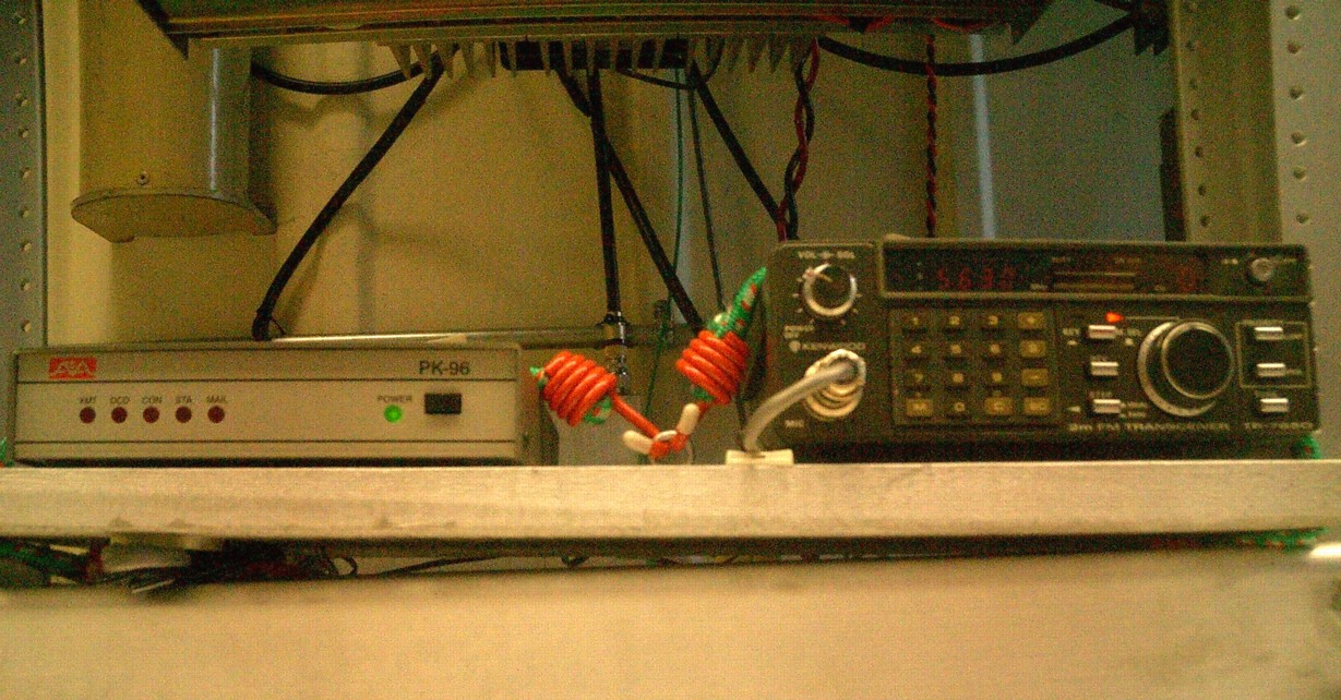
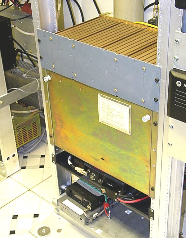
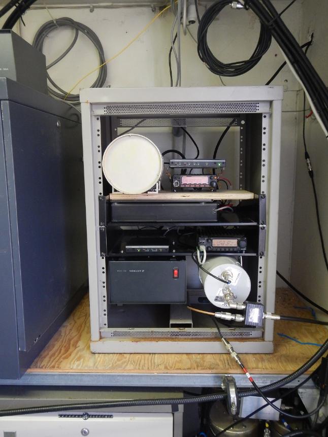
Pictures below, left to right: (1) NEILTN packet station; (2) Bandpass filter at Neilton; (3) MINOT Node; (4) HOLYX Node.


145.170 |  145.310 |  145.390 |  147.020 |  147.180 |  147.340 |  224.040 |  224.820 |  440.675 |  441.675 |  442.675 |  444.050 |  444.200 |  444.400 |  444.500 |  444.700 |  444.800 |  444.925 |  444.950
 

Home |  Frequencies |  Coverage Map |  More Info |  Pictures |  Technical Staff |  Pacific County Links |  Maintenance Log |  Site Map
 

For problems or questions regarding this website contact Webmaster. 

Copyright BeachNet Website 2002-2007. All rights reserved.
This Page Last Updated: 01/06/13.