These summaries highlight recent situations that potentially affected daily living on O'ahu and surrounding islands that could potentially escalate into emergency communications situations.
There are quite a number of incidents on Oahu each year that could potentially lead to situations requiring emergency communications.
Hurricane
- September 26-Sept 29, 2015;
Tropical Storm Niala
Approached Hawaii from the southeast.
 .
Threat of heavy rain and high surf on southern shores, Star-Advertiser (Sept 28)
.
Threat of heavy rain and high surf on southern shores, Star-Advertiser (Sept 28)
- August 28-Sept 9, 2015;
Tropical Storm Jimena
Approached Hawaii from the east.
Amateur radio operations
.
- August 23-Sept 1, 2015;
Tropical Storm Ignacio
Approached Hawaii from the east and north.
Amateur radio operations
.
- August 20-24, 2015;
Tropical Storm Kilo
Approached Hawaii from the east and south.
Amateur radio operations
.
- August 5-6, 2015;
Tropical Storm Guillermo
Approached Hawaii from the east.
Amateur radio operations
.
- October 17-19, 2014; Hurricane Ana Approached Hawaii from the southeast.Tropical Storm warning in effect for Maui and Big Island counties Friday, October 17. Tropical Storm warning in effect for Oahu and Kauai counties Saturday, October 18. Amateur radio operations. Power and telephone disrupted for two weeks. Record rainfall for BI and Oahu, causes Sand Island wastewater spill, Star-Advertiser (Oct 20)
- August 7-8, 2014;
Tropical Storm Iselle
Tropical Storm warning in effect for Maui and Big Island counties Thursday, August 7.
Approached Hawaii from the east.
Amateur radio operations
.
Power and telephone disrupted for two weeks.
16 days for power restoration, Star-Advertiser (Aug 25)
- ETA July 29, 2013;
Tropical Storm Flossie
Tropical Storm watch in effect for Maui and Big Island counties Saturday, July 27.
Flash flood watch in effect for the State of Hawaii Saturday, July 27.
Tropical Storm with estimated forecast 30 knot winds and heavy rainfall.
Approaching Hawaii from the east.
Amateur radio operations
.
- August 7-11, 2009; Hurricane Felicia Category 4 hurricane. Approached Hawaii from the east. Dissipated to a Category 2 hurricane and dissipated east of Kahului on Tuesday, August 11. Heavy rains and surf Aug 11-13 throughout the state. SCD, DEM and Skywarn ran daily informational nets without requiring full operation, and the daily nets were discontinued on Aug 11.
- August 14, 2007; Hurricane Flossie Category 3 hurricane. Approached Hawaii from the east. Dissipated to a tropical storm south of the Big Island on the evening of Tuesday, August 14. Passed south of the Big Island. Heavy Surf.
- July 19, 2007; Hurricane Cosme Category 1 hurricane. Approached Hawaii from the east. Dissipated to a tropical storm south of the Big Island on the evening of Monday, July 16. Passed 185 miles south of the Big Island. Gusts of 30 to 35 knots and heavy rain.
- September 2, 2003; Hurricane Jimena Category 2 hurricane. Approached Hawaii from the east. Passed 50 miles S of South Point at 6:30 am. Rain and flooding.
- July-Aug 2000 Hurricane Daniel, Tropical Storm. Approached Maui from the east; Veered north.
- Aug-Sept 1994 Hurricane John , Category 5
- July 21, 1994 Hurricane Emilia , Category 4
- Sept 11, 1992 Hurricane Iniki , Category 4. Approached Kauai from the south; Proceeded north.
- Nov 23, 1982 Hurricane Iwa , Category 1 Approached Kauai from the south.
- Aug 7, 1959 Hurricane Dot , Category 1 (Category 4 at it's peak)
Tsunami/Earthquake
Destructive tsunamis tend to cluster within two days of a full moon (94% phase), and within two days of a new moon (5% phase). This is due to the tidal forces caused by the gravitational attraction of the moon and sun. The tidal forces of the moon are about twice that of the sun.
Note that this does not mean that EVERY full and new moon will cause destructive tsunamis. Nor does it mean that destructive tsunamis must occur ONLY during full and new moons. It means that a destructive tsunami is more likely to occur during the full and new moon phase of the month compared to other days. This was the outcome of research conducted in 1998 due to the higher incidents of tsunami alerts and the resulting civil defense alerts during a full moon.
Note that Lunation 1091 produced a series of quakes primarily in the western half of the Pacific, including the March 10, 2011 Japan Tohoku quake. Earlier, Lunation 1090 produced a series of quakes primarily in the eastern half of the Pacific.
Events with destructive tsunamis, measured sea level changes or other disruptions are marked in bold. Events within two days of the full or new moon are marked in underline for the moon phase.
| Date | HST | Location | Coord | Mag | Moon Phase | Comments |
|---|---|---|---|---|---|---|
| December 17, 2015 | 09:49:54 AM | 9km ENE of Tres Picos, Mexico | 15.888N, 93.446W, 97.8 km | 6.6 Magnitude | 40% Waxing Cresent Lunation 1150, 365,468 kilometers | No tsunami for Hawaii. us100047zq. Star-Advertiser article. |
| November 24, 2015 | 12:45:38 AM | 169km WNW of Iberia, Peru | 10.548S, 70.904W, 600.6 km | 7.6 Magnitude | 98% Waxing Gibbous Lunation 1149, 367,553 kilometers | No tsunami for Hawaii. us100040ww. |
| November 18, 2015 | 08:31:04 AM | 115km SW of Dadali, Solomon Islands | 8.902S, 158.423E, 14.2 km | 7.0 Magnitude | 44% Waxing Crescent Lunation 1149, 370,034 kilometers | No tsunami for Hawaii. us10003zcp. |
| November 13, 2015 | 10:51:31 AM | 139km WSW of Makurazaki, Japan | 30.994N, 128.885E, 12.0 km | 6.7 Magnitude | 4% Waxing Crescent 1 day, 23 hours, 48 minutes Lunation 1149, 391,946 kilometers | No tsunami for Hawaii. us10003y71. Star-Advertiser article. |
| November 10, 2015 | 03:54:17 PM | 93km NW of Coquimbo, Chile | 29.439S, 72.105W, 10.0 km | 6.6 Magnitude | 0% New Moon 28 days, 22 hours, 14 minutes Lunation 1148, 401,831 kilometers | No tsunami for Hawaii. us10003x8t. Star-Advertiser article. |
| November 6, 2015 | 09:31:43 PM | 47km SW of Ovalle, Chile | 30.905S, 71.546W, 37.6 km | 6.8 Magnitude | 16% Waning Crescent Lunation 1148, 405,061 kilometers | No tsunami for Hawaii. us10003vgt. |
| October 20, 2015 | 11:52:02 AM | 35km NE of Port-Olry, Vanuatu | 14.842S, 167.306E, 127.0 km | 7.1 Magnitude | 50% Waxing Quarter Lunation 1148, 375,477 kilometers | No tsunami for Hawaii. us10003q0q. Star-Advertiser article. |
| September 24, 2015 | 05:53:27 AM | 27km N of Sorong, Indonesia | 0.631S, 131.244E, 18.0 km | 6.6 Magnitude | 83% Waxing Gibbous Lunation 1147, 369,983 kilometers | No tsunami for Hawaii. us20003nqr. Star-Advertiser article. |
| September 21, 2015 | 07:40:00 AM | 45km WSW of Illapel, Chile | 31.747S, 71.629W, 34.3 km | 6.5 Magnitude | 53% Waxing Gibbous Lunation 1147, 383,130 kilometers | No tsunami for Hawaii. us20003mi0s. Star-Advertiser article. |
| September 16, 2015 | 12:54:33 PM | 46km W of Illapel, Chile | 31.570S, 71.654W, 25.0 km | 8.3 Magnitude | 11% Waxing Crescent Lunation 1147, 402,221 kilometers | Tsunami watch and advisory for Hawaii. Final tsunami advisory for Hawaii. us20003k7a. Star-Advertiser article. Star-Advertiser article. |
| September 12, 2015 | 10:14:12 PM | 59km SSW of Topolobampo, Mexico | 25.156N, 109.377W, 10.0 km | 6.6 Magnitude | 0% New Moon 0 days, 1 hour, 16 minutes Lunation 1147, 405,035 kilometers | No tsunami for Hawaii. uus20003j4u. Star-Advertiser article. |
| August 14, 2015 | 09:47:06 AM | 214km W of Lata, Solomon Islands | 10.905S, 163.877E, 6.3 km | 6.6 Magnitude | 0% New Moon 0 days, 15 hours, 15 minutes Lunation 1146, 402,630 kilometers | No tsunami for Hawaii. us100032k6. Star-Advertiser article. |
| August 12, 2015 | 08:49:23 AM | 180km SE of Gizo, Solomon Islands | 9.319S, 157.934E, 5.0 km | 6.4 Magnitude | 3% Waning Crescent Lunation 1145, 394,395 kilometers | No tsunami for Hawaii. us100031me. Star-Advertiser article. |
| August 9, 2015 | 06:12:14 PM | 179km SW of Dadali, Solomon Islands | 9.346S, 158.056E, 15.0 km | 6.6 Magnitude | 18% Waning Crescent Lunation 1145, 382,541 kilometers | No tsunami for Hawaii. us100030pg. Star-Advertiser article. |
| July 27, 2015 | 11:41:21 AM | 230km W of Abepura, Indonesia | 2.683S, 138.508E, 48.0 km | 7.0 Magnitude | 84% Waxing Gibbous Lunation 1145, 386,198 kilometers | No tsunami for Hawaii. us200030kn. Star-Advertiser article. |
| July 26, 2015 | 06:49:46 PM | 73km SW of Nikolski, Alaska | 52.443N, 169.597W, 27.1 km | 6.9 Magnitude | 78% Waxing Gibbous Lunation 1145, 389,588 kilometers | No tsunami for Hawaii. us200030aq. Star-Advertiser article. |
| July 17, 2015 | 04:27:33 PM | 78km WNW of Lata, Solomon Islands | 10.444S, 165.172E, 10.0 km | 7.0 Magnitude | 4% Waxing Crescent Lunation 1145, 400,756 kilometers | No tsunami for Hawaii. us20002yaw. Star-Advertiser article. |
| July 09, 2015 | 06:12:41 PM | 155km SSW of Dadali, Solomon Islands | 9.314S, 158.423E, 10.0 km | 6.7 Magnitude | 35% Waning Crescent Lunation 1144, 367,808 kilometers | No tsunami for Hawaii. us20002whh. Star-Advertiser article. |
| June 27, 2015 | 10:10:10 PM | 13km S of Volcano, Hawaii | 19.335N, 155.209E, 8.6 km | 5.2 Magnitude | 84% Waxing Gibbous Lunation 1144, 395,166 kilometers | No tsunami for Hawaii. hv60968241. Star-Advertiser article. |
| June 21, 2015 | 11:28:15 AM | 42km ENE of Ndoi Island, Fiji | 20.457S, 178.351E, 561.4 km | 6.0 Magnitude | 26% Waxing Crescent Lunation 1144, 403,937 kilometers | No tsunami for Hawaii. us10002kra. Star-Advertiser article. |
| May 30, 2015 | 01:23:02 AM | 1190km WNW of Chichi-shima, Japan | 27.841N, 140.488E, 664.0 km | 7.8 Magnitude | 89% Waxing Gibbous Lunation 1143, 399,861 kilometers | No tsunami for Hawaii. us20002ki3. Star-Advertiser article. |
| May 22, 2015 | 01:59:33 PM | 159km ESE of Kirakira, Solomon Islands | 11.152S, 163.197E, 10.0 km | 6.8 Magnitude | 24% Waxing Crescent Lunation 1143, 397,585 kilometers | No tsunami for Hawaii. us10002bpw. Star-Advertiser article. |
| May 22, 2015 | 11:45:19 AM | 204km ESE of Kirakira, Solomon Islands | 11.072S, 163.684E, 9.9 km | 6.9 Magnitude | 23% Waxing Crescent Lunation 1143, 397,236 kilometers | No tsunami for Hawaii. us10002bnk. Star-Advertiser article. |
| May 20, 2015 | 12:48:53 PM | 184km W of Lata, Solomon Islands | 10.889S, 164.158E, 12.0 km | 6.8 Magnitude | 9% Waxing Crescent Lunation 1143, 388,756 kilometers | No tsunami for Hawaii. us10002b03. Star-Advertiser article. |
| May 12, 2015 | 11:12:58 AM | 33km SE of Ofunato, Japan | 38.902N, 142.032E, 38.9 km | 6.8 Magnitude | 33% Waning Gibbous Lunation 1142, 363,460 kilometers | No tsunami for Hawaii. us20002et4. Star-Advertiser article. |
| May 06, 2015 | 09:10:22 PM | 144km SW of Panguna, Papua New Guinea | 7.226S, 154.551E, 23.2 km | 7.1 Magnitude | 89% Waning Gibbous Lunation 1142, 381,298 kilometers | No tsunami for Hawaii. us20002das. Star-Advertiser article. |
| May 04, 2015 | 03:44:05 PM | 133km SSW of Kokopo, Papua New Guinea | 5.465S, 151.886E, 42.0 km | 7.5 Magnitude | 99% Full Moon 15 days, 15 hours, 36 minutes Lunation 1142, 391,689 kilometers | No tsunami for Hawaii. us20002bnf. Star-Advertiser article. |
| April 30, 2015 | 10:06:04 PM | 106km SSW of Kokopo, Papua New Guinea | 5.196S, 151.801E, 57.0 km | 6.8 Magnitude | 92% Waxing Gibbous Lunation 1142, 403,813 kilometers | No tsunami for Hawaii. us20002am6. Star-Advertiser article. |
| April 30, 2015 | 12:45:05 AM | 125km SSW of Kokopo, Papua New Guinea | 5.392S, 151.818E, 48.9 km | 6.7 Magnitude | 87% Waxing Gibbous Lunation 1142, 405,034 kilometers | No tsunami for Hawaii. us20002ag9. Star-Advertiser article. |
| April 19, 2015 | 03:42:58 PM | 66km SE of Su'ao, Taiwan | 24.194N, 122.327E, 29.0 km | 6.4 Magnitude | 2% New moon 1 day, 10 hours, 39 minutes Lunation 1142, 373,159 kilometers | No tsunami for Hawaii. us200027ps. Star-Advertiser article. |
| April 17, 2015 | 05:52:51 AM | 183km SSW of Sigave, Wallis and Futuna | 15.907S, 178.585W, 10.0 km | 6.5 Magnitude | 1% New moon 28 days, 5 hours, 55 minutes Lunation 1141, 365,210 kilometers | No tsunami for Hawaii. us200027c2. Star-Advertiser article. |
| April 5, 2015 | 03:23:52 AM | 7km W of Kalaoa, Hawaii | 19.748N, 156.101W, 10.0 km | 4.5 Magnitude | 98% Full moon 15 days, 17 hours, 28 minutes Lunation 1141, 399,507 kilometers | No tsunami for Hawaii. hv60887176. Star-Advertiser article. |
| March 29, 2015 | 10:48:26 PM | 99km ENE of Hihifo, Tonga | 15.515S, 172.940W, 15.5 km | 6.5 Magnitude | 77% Waxing Gibbous Lunation 1141, 402,413 kilometers | No tsunami for Hawaii. us10001ryu. Star-Advertiser article. |
| March 29, 2015 | 10:18:00 PM | 109km NE of Hihifo, Tonga | 15.338S, 172.904W, 11.5 km | 6.4 Magnitude | 77% Waxing Gibbous Lunation 1141, 402,362 kilometers | No tsunami for Hawaii. us10001ryq. Star-Advertiser article. |
| March 29, 2015 | 01:48:31 PM | 53km SE of Kokopo, Papua New Guinea | 4.736S, 152.558E, 41.0 km | 7.5 Magnitude | 74% Waxing Gibbous Lunation 1141, 401,458 kilometers | No tsunami for Hawaii. us10001rvu. Star-Advertiser article. |
| March 17, 2015 | 12:12:28 PM | 137km NW of Kota Ternate, Indonesia | 1.658N, 126.490E, 45.8 km | 6.2 Magnitude | 9% Waning Crescent Lunation 1140, 364,430 kilometers | No tsunami for Hawaii. us10001nab. Star-Advertiser article. |
| February 27, 2015 | 03:45:05 AM | 131km N of Nebe, Indonesia | 7.288S, 122.532E, 552.3 km | 7.0 Magnitude | 68% Waxing Gibbous Lunation 1140, 390,779 kilometers | No tsunami for Hawaii. usc000ttkd. Star-Advertiser article. |
| February 22, 2015 | 04:23:13 AM | 218km SW of Tomatlan, Mexico | 18.670N, 106.844W, 10.0 km | 6.2 Magnitude | 18% Waxing Crescent Lunation 1140, 368,512 kilometers | No tsunami for Hawaii. usc000tsak. |
| February 15, 2015 | 01:06:27 PM | 83km ENE of Miyako, Japan | 39.830N, 142.890E, 23.0 km | 6.7 Magnitude | 6% Waning Crescent Lunation 1139, 367,611 kilometers | No tsunami for Hawaii. usb000tpvj. Star-Advertiser article. |
| February 11, 2015 | 08:57:18 AM | 93km W of El Aguilar, Argentina | 23.123S, 66.599W, 190.8 km | 6.7 Magnitude | 53% Waning Gibbous Lunation 1139, 390,630 kilometers | No tsunami for Hawaii. usc000tp1s. Star-Advertiser article. |
| February 9, 2015 | 08:16:15 AM | 8.5 km (5.3 mi) WSW of Kilauea Summit (234 deg) | 19.3717N, 155.3418W, 7.5 km | 4.3 Magnitude | 72% Waning Gibbous Lunation 1139, 398,826 kilometers | No tsunami for Hawaii. hv60848586. Star-Advertiser article. |
| January 23, 2015 | 10:30:22 PM | 6.7 km (4.2 mi) SSW of Pu`u `O`o Crater (190 deg) | 19.3332N, 155.1202W, 7.5 km | 3.9 Magnitude | 19% Waxing Crescent Lunation 1139, 364,398 kilometers | No tsunami for Hawaii. hv60839711. |
| January 22, 2015 | 05:47:27 PM | 84km NNE of Port-Vila, Vanuatu | 17.000S, 168.531E, 281.5 km | 6.9 Magnitude | 9% Waxing Crescent Lunation 1139, 363,311 kilometers | No tsunami for Hawaii. usc000tihy. |
| January 06, 2015 | 07:07:08 PM | 245km S of Punta de Burica, Panama | 5.828N, 82.625W, 10.0 km | 6.6 Magnitude | 96% Waning Gibbous Lunation 1138, 403,219 kilometers | No tsunami for Hawaii. usc000tcba. |
| December 21, 2014 | 01:34:13 AM | 157km WNW of Tobelo, Indonesia | 2.118N, 126.650E, 41.0 km | 6.3 Magnitude | 0% New Moon 28 days, 21 hours, 22 minutes Lunation 1137, 376,296 kilometers | No tsunami for Hawaii. usc000t8vq. |
| December 07, 2014 | 10:54:52 PM | 20km ESE of Punta de Burica, Panama | 7.969N, 82.694W, 20.0 km | 6.6 Magnitude | 96% Waning Gibbous Lunation 1137, 396,377 kilometers | No tsunami for Hawaii. usc000t4iq. |
| December 06, 2014 | 03:22:00 PM | 116km WSW of Panguna, Papua New Guinea | 6.537S, 154.455E, 10.0 km | 6.8 Magnitude | 99% Waning Gibbous Full Moon Lunation 1137, 390,837 kilometers | No tsunami for Hawaii. usc000t4cz. |
| November 26, 2014 | 04:33:43 AM | 160km NW of Kota Ternate, Indonesia | 1.975N, 126.546E, 41.1 km | 6.8 Magnitude | 19% Waxing Crescent Lunation 1137, 366,347 kilometers | No tsunami for Hawaii. usb000t08w. Star-Advertiser article. |
| November 21, 2014 | 12:10:19 AM | 122km WNW of Tobelo, Indonesia | 2.277N, 127.055E, 38.1 km | 6.5 Magnitude | 1% Waning Crescent Lunation 1136, 388,112 kilometers | No tsunami for Hawaii. usb000syhz. Star-Advertiser article. |
| November 16, 2014 | 12:33:20 PM | 182km NE of Gisborne, New Zealand | 37.682S, 179.685E, 22.0 km | 6.7 Magnitude | 28% Waning Crescent Lunation 1136, 403,897 kilometers | No tsunami for Hawaii. usc000sxye. Star-Advertiser article. |
| November 14, 2014 | 04:31:40 PM | 156km NW of Kota Ternate, Indonesia | 1.928N, 125.547E, 35.0 km | 7.1 Magnitude | 45% Waning Crescent Lunation 1136, 405,503 kilometers | No tsunami for Hawaii. usc000sxh8. Star-Advertiser article. |
| November 6, 2014 | 05:33:54 PM | 72km NNE of Finschhafen, Papua New Guinea | 6.044S, 148.210E, 43.2 km | 6.6 Magnitude | 99% Waning Gibbous Lunation 1136, 379,675 kilometers | No tsunami for Hawaii. usc000sv94. Star-Advertiser article. |
| October 13, 2014 | 05:51:35 PM | 67km WSW of Jiquilillo, Nicaragua | 12.576N, 88.046W, 44.0 km | 7.3 Magnitude | 65% Waning Gibbous Lunation 1135, 396,515 kilometers | No tsunami for Hawaii. usb000slwn. Star-Advertiser article. |
| October 8, 2014 | 04:14:32 PM | Southern East Pacific Rise | 32.154S, 110.815W, 10.0 km | 7.1 Magnitude | 99% Waning Gibbous Lunation 1135, 373,016 kilometers | No tsunami for Hawaii. usb000sk6k. Star-Advertiser article. |
| September 16, 2014 | 08:14:46 PM | 45km NW of Piti Village, Guam | 13.756N, 144.397E, 136.7 km | 6.7 Magnitude | 38% Waning Crescent Lunation 1134, 399,114 kilometers | No tsunami for Hawaii. usb000sdcr. Star-Advertiser article. |
| September 9, 2014 | 04:46:06 PM | 132km SE of Modayag, Indonesia | 0.186S, 125.173E, 30.0 km | 6.2 Magnitude | 98% Full Moon 15 days, 23 hours, 4 minutesLunation 1134, 367,910 kilometers | No tsunami for Hawaii. usb000say6. Star-Advertiser article. Star-Advertiser article. |
| August 24, 2014 | 01:21:45 PM | 43km ENE of Tambo, Peru | 14.586S, 73.578W, 101.0 km | 6.9 Magnitude | 0% New Moon 28 days, 23 hours, 12 minutes Lunation 1133, 405,379 kilometers | No tsunami for Hawaii. usb000s5x1. Star-Advertiser article. |
| August 22, 2014 | 02:37:13 AM | 73km WSW of Lana'i City, Hawaii | 20.6400N, 157.5950W, 20.0 km | 4.1 Magnitude | 8% Waning Crescent Lunation 1133, 403,765 kilometers | No tsunami for Hawaii. pt14234000. Star-Advertiser article. |
| August 7, 2014 | 06:24:04 AM | 14km WNW of Waimea, Hawaii | 20.0788N, 155.7935W, 16.8 km | 4.5 Magnitude | 86% Waxing Gibbous Lunation 1133, 368,830 kilometers | No tsunami for Hawaii. hv60748981. Star-Advertiser article. |
| August 2, 2014 | 02:22:03 PM | Federated States of Micronesia region | 0.844N, 146.144E, 10.6 km | 6.9 Magnitude | 39% Waxing Crescent Lunation 1133, 389,945 kilometers | No tsunami for Hawaii. usb000rzki. Star-Advertiser article. |
| July 21, 2014 | 04:54:41 AM | 94km NNE of Ndoi Island, Fiji | 19.829S, 178.464W, 616.4 km | 6.9 Magnitude | 24% Waning Gibbous Lunation 1132, 388,523 kilometers | No tsunami for Hawaii. usb000ruzk. Star-Advertiser article. |
| July 17, 2014 | 01:49:37 AM | 95km NNW of Yakutat, Alaska | 60.2171N, 140.5501W, 14 km | 6.0 Magnitude | 67% Waning Gibbous Lunation 1132, 369,875 kilometers | No tsunami for Hawaii. ak11328120. Star-Advertiser article. |
| July 11, 2014 | 09:22:00 AM | 129km ESE of Namie, Japan | 37.605N, 142.365E, 11.1 km | 6.5 Magnitude | 99% Full Moon 13 days, 23 hours, 47 minutes Lunation 1132, 366,555 kilometers | No tsunami for Hawaii. usb000rs50. Star-Advertiser article. |
| July 11, 2014 | 01:13:56 AM | 62 km (39 mi) ENE of Kahului, Maui | 21.0657N, 155.8983W, 34.5 km | 3.1 Magnitude | 98% Full Moon 13 days, 14 hours, 26 minutes Lunation 1132, 367,541 kilometers | hv60730086. Star-Advertiser article. |
| July 7, 2014 | 01:23:55 AM | 2km NNE of Puerto Madero, Mexico | 14.742N, 92.409W, 60.0 km | 7.1 Magnitude | 69% Waxing Gibbous Lunation 1132 | No tsunami for Hawaii. usc000rr6a. Star-Advertiser article. |
| July 4, 2014 | 05:00:26 AM | 193km S of Taron, Papua New Guinea | 6.205S, 152.821E, 10.0 km | 6.6 Magnitude | 41% Waxing Crescent Lunation 1132 | No tsunami for Hawaii. usc000rqgz. Star-Advertiser article. |
| July 3, 2014 | 09:50:05 AM | 193km SE of Raoul Island, New Zealand | 30.533S, 176.526W,20.0 km | 6.3 Magnitude | 33% Waxing Crescent Lunation 1132 | No tsunami for Hawaii. usc000rqbg. |
| June 29, 2014 | 07:15:08 AM | 211km SSE of Mata-Utu, Wallis and Futuna | 15.103S, 175.569E, 11.4 km | 5.8 Magnitude | 4% Waxing Crescent Lunation 1132 | No tsunami for Hawaii. usc000rnku. Star-Advertiser article. |
| June 29, 2014 | 05:22:22 AM | 197km NW of Hihifo, Tonga | 14.909S, 175.244E, 10.0 km | 6.4 Magnitude | 4% Waxing Crescent Lunation 1132 | No tsunami for Hawaii. usc000rnk7. Star-Advertiser article. |
| June 23, 2014 | 05:15:41 PM | 52km E of Buldir Island, Alaska | 52.307N, 176.693E, 35.0 km | 6.6 Magnitude | 9% Waning Crescent Lunation 1131 | No tsunami for Hawaii. usc000rkvn. Star-Advertiser article. |
| June 23, 2014 | 10:53:09 AM | 24km SE of Little Sitkin Island, Alaska | 51.797N, 178.760E, 107.5 km | 7.9 Magnitude | 11% Waning Crescent Lunation 1131 | No tsunami for Hawaii. usc000rki5. Star-Advertiser article. |
| June 23, 2014 | 09:19:16 AM | 96km SSE of Raoul Island, New Zealand | 30.118S, 177.670E, 20.0 km | 6.9 Magnitude | 12% Waning Crescent Lunation 1131 | No tsunami for Hawaii. usc000rkg5. Star-Advertiser article. |
| June 6, 2014 | 04:42:24 PM | 14km NNW of Kualapu'u, Hawaii | 21.267N, 157.106W, 8.9 km | 3.8 Magnitude | 62% Waxing Gibbous Lunation 1131 | No tsunami for Hawaii. pt14158000. Star-Advertiser article. |
| May 31, 2014 | 10:53:48 AM | 259km WSW of Tomatlan, Mexico | 18.852N, 107.445W, 10.0 km | 6.2 Magnitude | 7% Waxing Crescent Lunation 1131 | No tsunami for Hawaii. usc000r9g2. Star-Advertiser article. |
| May 14, 2014 | 10:16:34 PM | 96km SSE of Ifalik, Micronesia | 6.509N, 144.899E, 10.0 km | 6.6 Magnitude | 99% Waning Gibbous Lunation 1130 | No tsunami for Hawaii. usb000qngw. |
| May 14, 2014 | 10:56:13 AM | 99km SSE of Ifalik, Micronesia | 6.458N, 144.877E, 10.6 km | 6.1 Magnitude | 99% Waning Gibbous Lunation 1130 | No tsunami for Hawaii. usb000qn2z. Star-Advertiser article. |
| May 12, 2014 | 08:35:24 PM | 105km SE of Punta de Burica, Panama | 7.249N, 82.330W, 10 km | 6.8 Magnitude | 97% Waxing Gibbous Lunation 1130 | No tsunami for Hawaii. usb000qk64. Star-Advertiser article. |
| May 8, 2014 | 07:00:17 AM | 15km N of Tecpan de Galeana, Mexico | 17.385N, 100.656W, 23.9 km | 6.4 Magnitude | 64% Waxing Gibbous Lunation 1130 | No tsunami for Hawaii. usb000qea2. Star-Advertiser article. |
| May 4, 2014 | 11:15:53 PM | South of the Fiji Islands | 24.642S, 179.084E, 527.6 km | 6.8 Magnitude | 27% Waxing Crescent Lunation 1130 | No tsunami for Hawaii. usb000q98a. |
| April 30, 2014 | 08:36:35 PM | 201km WNW of Ile Hunter, New Caledonia | 21.502S, 170.352E, 105.3 km | 6.6 Magnitude | 4% Waxing Crescent Lunation 1130 | No tsunami for Hawaii. usb000q66s. |
| April 24, 2014 | 05:10:12 PM | 94km S of Port Hardy, Canada | 49.846N, 127.444W, 11.4 km | 6.7 Magnitude | 29% Waning Crescent Lunation 1129 | No tsunami for Hawaii. usb000px6r. |
| April 19, 2014 | 03:27:59 AM | 75km SW of Panguna, Papua New Guinea | 6.720S, 154.931E, 30.9 km | 7.5 Magnitude | 79% Waning Gibbous Lunation 1129 | No tsunami for Hawaii. usb000pr89. Star-Advertiser article. |
| April 18, 2014 | 03:04:00 PM | 59km SW of Panguna, Papua New Guinea | 6.679S, 155.085E, 24.4 km | 6.6 Magnitude | 84% Waning Gibbous Lunation 1129 | No tsunami for Hawaii. usb000pqwe. Star-Advertiser article. |
| April 18, 2014 | 04:27:26 AM | 36km NNW of Tecpan de Galeana, Mexico | 17.552N, 100.816W, 24.0 km | 7.2 Magnitude | 87% Waning Gibbous Lunation 1129 | No tsunami for Hawaii. usb000pq41. Star-Advertiser article. |
| April 12, 2014 | 02:36:18 AM | 111km S of Kirakira, Solomon Islands | 11.451S, 162.069E, 35.0 km | 7.4 Magnitude | 96% Waxing Gibbous Lunation 1129 | No tsunami for Hawaii. usc000piqj. Star-Advertiser article. |
| April 12, 2014 | 10:14:39 AM | 100km SSE of Kirakira, Solomon Islands | 11.315S, 162.211E, 29.3 km | 7.6 Magnitude | 93% Waxing Gibbous Lunation 1129 | No tsunami for Hawaii. usc000phx5. Star-Advertiser article. |
| April 11, 2014 | 10:29:15 AM | 11km ESE of Nandaime, Nicaragua | 11.710N, 85.963W, 138.6 km | 6.6 Magnitude | 87% Waxing Gibbous Lunation 1129 | No tsunami for Hawaii. usc000pgsi. Star-Advertiser article. |
| April 10, 2014 | 10:16:48 PM | 78km SW of Panguna, Papua New Guinea | 6.855S, 155.017E, 39.4 km | 6.8 Magnitude | 84% Waxing Gibbous Lunation 1129 | No tsunami for Hawaii. usc000pfuy. |
| April 10, 2014 | 9:07:21 PM | 57km SW of Panguna, Papua New Guinea | 6.625S, 155.064E, 50.0 km | 7.1 Magnitude | 84% Waxing Gibbous Lunation 1129 | No tsunami for Hawaii. usc000pft9. Star-Advertiser article. |
| April 2, 2014 | 04:43:14 PM | 50km SW of Iquique, Chile | 20.518S, 70.505W, 31.8 km | 7.6 Magnitude | 12% Waxing Crescent Lunation 1129 | No tsunami for Hawaii. usc000p27i. Star-Advertiser article. |
| April 1, 2014 | 01:46:46 PM | 95km NW of Iquique, Chile | 19.642S, 70.817W, 20.1 km | 8.2 Magnitude | 5% Waxing Crescent Lunation 1129 | Tsunami advisory for Hawaii. usc000nzvd. Star-Advertiser article. Star-Advertiser article. |
| March 25, 2014 | 05:29:36 PM | South of the Fiji Islands | 26.092S, 179.279E, 493 km | 6.5 Magnitude | 26% Waning Crescent Lunation 1128 | No tsunami for Hawaii expected. usc000nqnq. |
| March 16, 2014 | 11:16:30 AM | 60km WNW of Iquique, Chile | 19.925S, 70.628W, 20 km | 6.7 Magnitude | 99% Full Moon 14 days, 21 hours, 55 minutes Lunation 1128 | No tsunami for Hawaii expected. usc000ndnj. Star-Advertiser article. |
| March 9, 2014 | 07:18:13 PM | 77km WNW of Ferndale, California | 40.829N, 125.134W, 16.6 km | 6.8 Magnitude | 65% Waxing Gibbous Lunation 1128 | No tsunami for Hawaii expected. nc72182046. |
| March 2, 2014 | 10:11:22 AM | Ryukyu Islands, Japan | 27.405N, 127.335E, 111.2 km | 6.5 Magnitude | 3% New Moon 1 days, 16 hours, 14 minutes Lunation 1128 | No tsunami for Hawaii expected. usb000mzmn. |
| February 6, 2014 | 10:40:13 PM | 31km E of Port-Olry, Vanuatu | 15.060S, 167.339E, 117.7 km | 6.5 Magnitude | 55% Waxing Gibbous Lunation 1127 | No tsunami for Hawaii expected. usc000mjye. Star-Advertiser article. |
| February 1, 2014 | 11:26:37 PM | 1192km SSE of L'Esperance Rock, New Zealand | 132.908S, 177.822W, 40 km | 6.5 Magnitude | 8% Waxing Crescent Lunation 1127 | No tsunami for Hawaii expected. usc000mfm0. |
| January 20, 2014 | 3:29:13 PM | 159km WNW of Hihifo, Tonga | 15.250S, 175.051W, 10 km | 5.9 Magnitude | 79% Waning Gibbous Lunation 1126 | No tsunami for Hawaii expected. usb000m5ge. Star-Advertiser article. |
| January 1, 2014 | 6:03:30 AM | 37km W of Sola, Vanuatu | 13.873S, 167.202E, 196.2 km | 6.6 Magnitude | 0% New Moon 0 days, 5 hours, 43 minutes Lunation 1126 | No tsunami for Hawaii expected. usc000lvb5. Star-Advertiser article. |
| November 21, 2013 | 7:36:03 AM | 40 Miles Southwest of Hilo, Hawaii; 9.9 km (6.2 mi) NNE of Pahala | 19.2937N, 155.4662W, 8.2 km | 2.5 Magnitude | 84% Waning Gibbous Lunation 1124 | No tsunami for Hawaii expected. hv60594766. Star-Advertiser article. |
| November 11, 2013 | 9:03:51 PM | 172km S of Ust'-Kamchatsk Staryy, Russia | 54.681N, 162.286E, 47.2 km | 6.6 Magnitude | 71% Waxing Gibbous Lunation 1124 | No tsunami for Hawaii expected. usb000kw1x. |
| November 2, 2013 | 8:53:46 AM | 151km ESE of Neiafu, Tonga | 19.128S, 172.634W, 10.0 km | 6.2 Magnitude | 0% Waning Crescent 28 days, 17 hours, 17 minutes Lunation 1123 | No tsunami for Hawaii expected. usb000krlz. Star-Advertiser article. |
| October 31, 2013 | 1:03:59 PM | 43km SSW of Coquimbo, Chile | 30.298S, 71.557W, 29.0 km | 6.6 Magnitude | 8% Waning Crescent Lunation 1123 | No tsunami for Hawaii expected. usb000kqnc. Star-Advertiser article. |
| October 31, 2013 | 2:02:09 AM | 45km SSW of Hualian, Taiwan | 23.591N, 121.433E, 12.0 km | 6.3 Magnitude | 10% Waning Crescent Lunation 1123 | No tsunami for Hawaii expected. usc000ksdy. Star-Advertiser article. |
| October 25, 2013 | 7:10:15 AM | Off the east coast of Honshu, Japan | 37.165N, 144.708W, 8.1 km | 7.1 Magnitude | 61% Waning Gibbous Lunation 1123 | No tsunami for Hawaii expected. usc000kn4n. Star-Advertiser article. |
| October 19, 2013 | 7:54:56 AM | 75km SW of Etchoropo, Mexico | 26.268N, 110.178W, 8 km | 6.5 Magnitude | 99% Waning Gibbous Lunation 1123 | No tsunami for Hawaii expected. usb000khbc. Star-Advertiser article. |
| October 16, 2013 | 12:31:00 AM | 64km WSW of Panguna, Papua New Guinea | 6.4873S, 154.928W, 54.06 km | 6.8 Magnitude | 92% Waxing Gibbous Lunation 1123 | No tsunami for Hawaii expected. usb000kemb. Star-Advertiser article. |
| October 14, 2013 | 2:12:32 PM | 2km NE of Catigbian, Philippines | 9.8662N, 124.0115E, 20 km | 7.1 Magnitude | 82% Waxing Gibbous Lunation 1123 | No tsunami for Hawaii expected. usb000kdb4. Star-Advertiser article. Star-Advertiser article. |
| September 29, 2013 | 07:55:54 PM | 81km NE of L'Esperance Rock, New Zealand | 30.956S, 178.244W, 34.8 km | 6.7 Magnitude | 22% Waning Crescent Lunation 1122 | No tsunami for Hawaii expected. usb000k2h2. Star-Advertiser article. |
| September 25, 2013 | 06:42:42 AM | 50km S of Acari, Peru | 15.882S, 74.543W, 40.0 km | 7.0 Magnitude | 63% Waning Gibbous Lunation 1122 | No tsunami for Hawaii expected. usb000jzma. Star-Advertiser article. |
| September 3, 2013 | 04:32:33 AM | 77km SSW of Atka, Alaska | 51.592N, 174.760W, 39.3 km | 6.5 Magnitude | 1% Waning Crescent 28 days, 4 hours, 56 minutes Lunation 1121 | No tsunami for Hawaii expected. usb000jgju. Star-Advertiser article. |
| August 30, 2013 | 06:25:02 AM | 94km ESE of Adak, Alaska | 51.610N, 175.361W, 33.5 km | 7.0 Magnitude | 28% Waning Crescent Lunation 1121 | No tsunami for Hawaii expected. No tsunami for Hawaii expected. usb000jdt7. Star-Advertiser article. |
| August 13, 2013 | 05:43:14 AM | 102km WSW of Mutis, Colombia | 5.757N, 78.200W, 10.0 km | 6.7 Magnitude | 41% Waxing Crescent Lunation 1121 | No tsunami for Hawaii expected. usb000j275. Star-Advertiser article. |
| August 11, 2013 | 05:54:05 AM | 9 km ( 6 mi) S of Kilauea Summit | 19.337N, 155.269W, 33.0 km | 4.9 Magnitude | 21% Waxing Crescent Lunation 1121 | No tsunami for Hawaii expected. hv60521547. Star-Advertiser article. |
| July 29, 2013 | 10:30:59 AM | Oahu Region, Hawaii | 21.2783N, 157.6048W, 32 km | 3.7 Magnitude | 48% Waning Crescent Lunation 1120 | No tsunami for Hawaii expected. hv60534471. Star-Advertiser article - Mild earthquake recorded off Waimanalo Beach. |
| July 20, 2013 | 07:09:31 PM | 46km ESE of Blenheim, New Zealand | 41.713S, 174.443E, 14.0 km | 6.5 Magnitude | 96% Waxing Gibbous Lunation 1120 | No tsunami for Hawaii expected. usb000iivv. Star-Advertiser article. |
| July 7, 2013 | 08:35:30 AM | North of the Solomon Islands | 3.939S, 153.882E, 378.8 km | 7.3 Magnitude | 0% New Moon 29 days, 1 hour, 33 minutes Lunation 1119 | No tsunami for Hawaii expected. usb000i89z. Star-Advertiser article. |
| June 21, 2013 | 12:04:11 AM | Off the North coast of Molokai | 21.590N, 157.010W, 25.1 km | 4.0 Magnitude | 93% Waxing Gibbous Lunation 1119 | No tsunami for Hawaii expected. pt13172000. Star-Advertiser article. |
| June 15, 2013 | 07:34:29 AM | 50km W of Masachapa, Nicaragua | 11.725N, 86.975W, 35.8 km | 6.5 Magnitude | 39% Waxing Crescent Lunation 1119 | No tsunami for Hawaii expected. usc000hrnr. Star-Advertiser article. |
| June 04, 2013 | 02:12:39 PM | In The Deep Ocean Southeast Of The Big Island | 18.915N, 155.061W, 40.3 km | 5.3 Magnitude | 11% Waning Crescent Lunation 1118 | No tsunami for Hawaii expected. hv60508246. Star-Advertiser article. |
| June 01, 2013 | 07:43:04 PM | Taiwan | 23.794N, 121.082E, 20.0 km | 6.5 Magnitude | 34% Waning Crescent Lunation 1118 | No tsunami for Hawaii expected. usb000hbrt. Star-Advertiser article. |
| May 24, 2013 | 04:56:31 AM | Sea of Okhotsk | 52.222N, 151.515E, 623.0 km | 6.3 Magnitude | 99% Waxing Gibbous Lunation 1118 | No tsunami for Hawaii expected. usb000h543. Star-Advertiser article. |
| May 23, 2013 | 07:44:49 PM | Sea of Okhotsk | 54.874N, 153.280E, 608.9 km | 8.3 Magnitude | 98% Waxing Gibbous Lunation 1118 | No tsunami for Hawaii expected. usb000h4jh. Star-Advertiser article. |
| May 23, 2013 | 11:07:46 AM | 84km NW of Nuku`alofa, Tonga | 20.557S, 175.739E, 154.1 km | 6.3 Magnitude | 97% Waxing Gibbous Lunation 1118 | No tsunami for Hawaii expected. usb000h40b. |
| May 23, 2013 | 07:19:04 AM | 282km SW of Vaini, Tonga | 23.025S, 177.109E, 171.4 km | 7.4 Magnitude | 96% Waxing Gibbous Lunation 1118 | No tsunami for Hawaii expected. usb000h3k3. Star-Advertiser article. |
| May 19, 2013 | 11:49:04 PM | Off the coast of Aisen, Chile | 44.944S, 81.541E, 10.0 km | 6.5 Magnitude | 72% Waxing Gibbous Lunation 1118 | No tsunami for Hawaii expected. usb000gzlm. Star-Advertiser article. |
| May 13, 2013 | 02:32:25 PM | 39km W of Agrihan, Northern Mariana Islands | 18.748N, 145.294E, 601.8 km | 6.8 Magnitude | 14% Waxing Crescent Lunation 1118 | No tsunami for Hawaii expected. usc000gw27. Star-Advertiser article. |
| May 11, 2013 | 10:46:56 AM | Tonga | 17.944S, 175.075W, 205.4 km | 6.5 Magnitude | 3% Waxing Crescent Lunation 1118 | No tsunami for Hawaii expected. usc000gudx. Star-Advertiser article. |
| April 23, 2013 | 01:14:42 PM | New Ireland Region Papua New Guinea | 3.920S, 152.123E, 21.8 km | 6.5 Magnitude | 95% Waxing Gibbous Lunation 1117 | No tsunami for Hawaii expected. usb000gen8. Star-Advertiser article. |
| April 18, 2013 | 05:05:53 PM | Kuril Islands | 46.182N, 150.796E, 122.3 km | 7.2 Magnitude | 55% Waxing Gibbous Lunation 1117 | No tsunami for Hawaii expected. usb000gbf8. Star-Advertiser article. |
| April 16, 2013 | 12:55:27 PM | Near the North Coast of New Guinea P.N.G | 3.218S, 142.543E, 13 km | 6.6 Magnitude | 35% Waxing Crescent Lunation 1117 | No tsunami for Hawaii expected. usb000g8my. Star-Advertiser article. |
| April 13, 2013 | 03:32:00 AM | Solomon Islands | 6.479S, 154.584W, 35.3 km | 6.6 Magnitude | 12% Waxing Crescent Lunation 1117 | No tsunami for Hawaii expected. usb000g6lc. |
| April 13, 2013 | 10:45:20 AM | In the deep ocean Northeast of the Big Island | 20.341N, 155.071W, 17.8 km | 4.4 Magnitude | 11% Waxing Crescent Lunation 1117 | No tsunami for Hawaii expected. usb000g6fd. Star-Advertiser article. |
| April 11, 2013 | 04:27:54 AM | Off the North Coast of Molokai | 21.469N, 157.256W, 10.1 km | 2.6 Magnitude | 1% New Moon 1 day, 3 hours, 21 minutes Lunation 1117 | No tsunami for Hawaii expected. hv60488256. Wave Forms. Star-Advertiser article. |
| April 5, 2013 | 06:42:36 PM | Papua, Indonesia | 3.526S, 138.466E, 68 km | 7.0 Magnitude | 18% Waning Crescent Lunation 1116 | No tsunami for Hawaii expected. usb000g13s. |
| March 10, 2013 | 12:51:51 PM | New Britian Region Papua New Guinea | 6.653S, 148.155E, 28.9 km | 6.7 Magnitude | 0% New Moon 28 days, 14 hours, 57 minutes Lunation 1115 | No tsunami for Hawaii expected. usb000fij4. |
| March 1, 2013 | 03:20:50 AM | Kuril Islands | 50.945N, 157.476E, 31.7 km | 6.5 Magnitude | 84% Waning Gibbous Lunation 1115 | No tsunami for Hawaii expected. usc000feww. |
| February 28, 2013 | 04:05:51 AM | Kuril Islands | 50.934N, 157.339E, 52.6 km | 6.9 Magnitude | 91% Waning Gibbous Lunation 1115 | No tsunami for Hawaii expected. usc000febi. |
| February 14, 2013 | 03:13:53 AM | Eastern Siberia, Russia | 67.580N, 142.503E, 10.1 km | 6.6 Magnitude | 19% Waxing Crescent Lunation 1115 | No tsunami for Hawaii expected. usc000f76f. |
| February 09, 2013 | 11:02:22 AM | Santa Cruz Islands | 10.964S, 165.792E, 15.7 km | 6.6 Magnitude | 0% New Moon 29 days, 1 hour, 37 minutes Lunation 1114 | No tsunami for Hawaii expected. usc000f4n5. |
| February 09, 2013 | 04:16:09 AM | Columbia | 1.167N, 77.384W, 153.8 km | 6.9 Magnitude | 0% New Moon 28 days, 18 hours, 11 minutes Lunation 1114 | No tsunami for Hawaii expected. usc000f4ij. |
| February 08, 2013 | 05:26:39 AM | Santa Cruz Islands | 10.910S, 165.964E, 27 km | 7.0 Magnitude | 3% Waning Crescent Lunation 1114 | No tsunami for Hawaii expected. usc000f40j. |
| February 08, 2013 | 01:12:12 AM | Santa Cruz Islands | 10.925S, 165.975E, 10 km | 7.1 Magnitude | 4% Waning Crescent Lunation 1114 | No tsunami for Hawaii expected. usc000f3x8. |
| February 07, 2013 | 08:59:16 AM | Santa Cruz Islands | 11.001S, 165.658E, 10 km | 6.6 Magnitude | 8% Waning Crescent Lunation 1114 | No tsunami for Hawaii expected. usc000f3fx. |
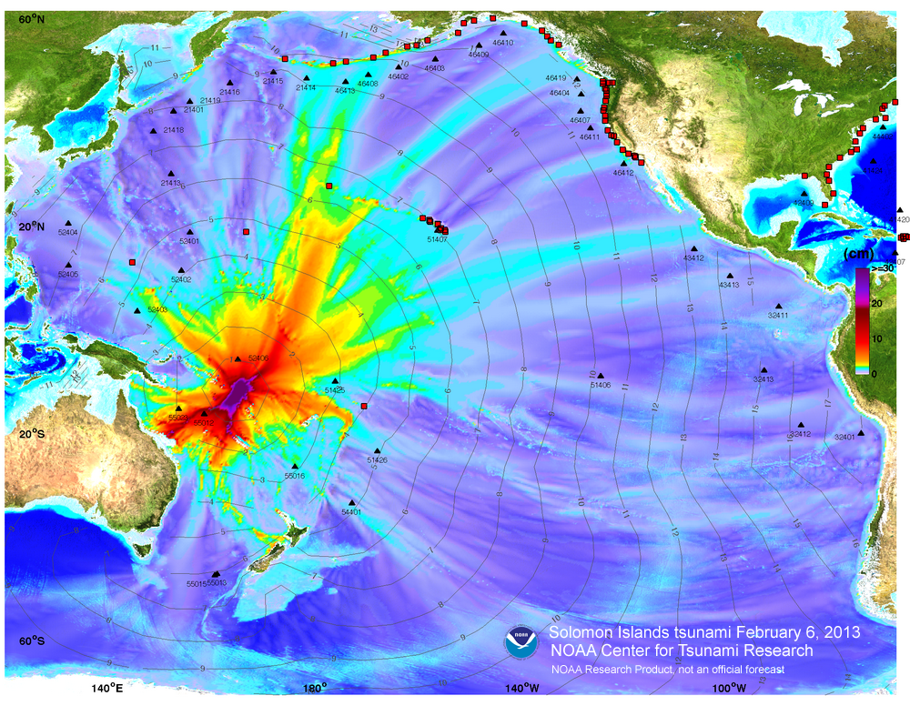
| February 05, 2013 | 03:12:27 PM | Santa Cruz Islands | 10.738S, 165.138E, 28.7 km | 8.0 Magnitude | 23% Waning Crescent Lunation 1114 | No tsunami for Hawaii expected. Pacific Bulletin. usc000f1s0. PMEL Forecast Model. 5 ft Solomon Islands tsunami. |
| February 02, 2013 | 04:17:34 AM | Hokkaido, Japan Region | 42.812N, 143.078W, 103.1 km | 6.9 Magnitude | 60% Waning Gibbous Lunation 1114 | No tsunami for Hawaii expected. usc000f03a. |
| February 01, 2013 | 12:16:36 AM | Santa Cruz Islands | 10.926S, 165.450E, 19.9 km | 6.3 Magnitude | 68% Waning Gibbous Lunation 1114 | No tsunami for Hawaii expected. usc000ezv6. |
| January 30, 2013 | 11:53:43 PM | Southeastern Alaska | 55.584N, 134.745W, 9.7 km | 6.0 Magnitude | 82% Waning Gibbous Lunation 1114 | No tsunami for Hawaii expected. usc000ez52. |
| January 30, 2013 | 10:15:42 AM | Central Chile | 28.180S, 70.784W, 42.7 km | 6.8 Magnitude | 86% Waning Gibbous Lunation 1114 | No tsunami for Hawaii expected. usc000eyp3. |
| January 05, 2013 | 04:37:18 AM | On the South flank of Kilauea Volcano, 7 km (4 miles) SE of Puʻu ʻOʻo Crater | 19.343N, 155.069W, 9.1 km | 4.4 Magnitude | 45% Waning Crescent Lunation 1113 | No tsunami for Hawaii expected. hv60447191. |
| January 04, 2013 | 10:58:19 PM | Southeastern Alaska | 55.368N, 134.621W, 9.8 km | 7.6 Magnitude | 48% Waning Crescent Lunation 1113 | No tsunami, however sea level changes expected starting 0428 am HST. usc000ejqv. |
| December 21, 2012 | 12:28:00 PM | Vanuatu | 14.382S, 167.260E, 207.9 km | 6.8 Magnitude | 66% Waxing Gibbous Lunation 1113 | No tsunami for Hawaii expected. usc000eek3. |
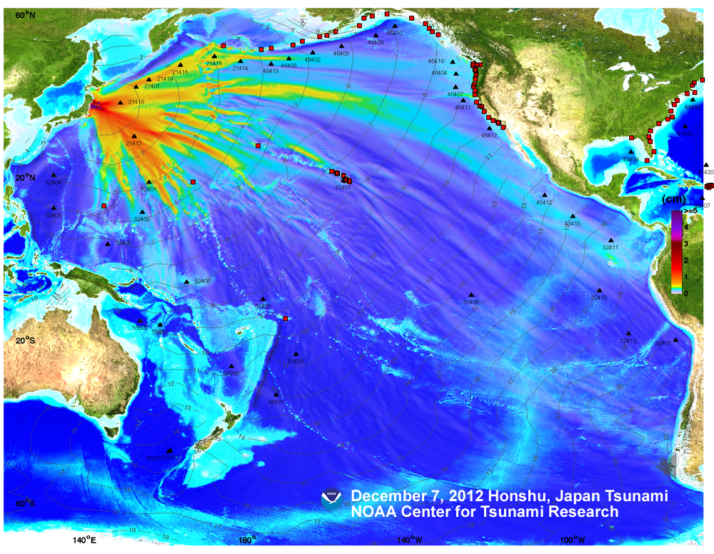
| December 06, 2012 | 10:18:24 PM | Off the East coast of Honshu, Japan | 37.889N, 144.090E, 36.1 km | 7.3 Magnitude | 42% Waning Crescent Lunation 1112 | No tsunami for Hawaii expected. usc000e5n4. PMEL Forecast Model. |
| November 24, 2012 | 03:59:46 PM | At Loihi Seamount, South of the Big Island | 18.952N, 155.192E, 16.9 km | 4.1 Magnitude | 89% Waxing Gibbous Lunation 1112 | No tsunami for Hawaii expected. hv60434266. |
| November 16, 2012 | 08:12:39 AM | Kuril Islands | 49.269N, 155.472E, 29.1 km | 6.4 Magnitude | 1% Waxing Crescant Lunation 1112 | No tsunami for Hawaii expected. usc000dtr7. |
| November 12, 2012 | 10:42:17 AM | Gulf of Alaska | 57.605N, 142.899E, 12 km | 6.4 Magnitude | 1% Waning Crescant Lunation 1111 | No tsunami for Hawaii expected. ak10598710. |
| November 11, 2012 | 12:15:00 PM | Off the coast of Chiapas Mexico | 14.164N, 92.167E, 27 km | 6.5 Magnitude | 5% Waning Crescant Lunation 1111 | No tsunami for Hawaii expected. usc000dr09. |
| November 7, 2012 | 06:35:50 AM | Off the coast of Chiapas Mexico | 14.083N, 91.916E, 41.6 km | 7.4 Magnitude | 43% Waning Crescant Lunation 1111 | No tsunami for Hawaii expected. usb000dlwm. |
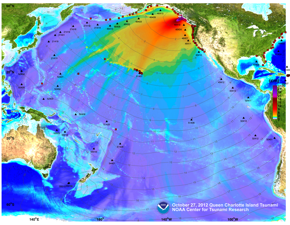
| October 27, 2012 | 05:04:10 PM | Queen Charlotte Islands, BC, Canada | 52.769N, 131.927W, 17.5 km | 7.7 Magnitude | 97% Waxing Gibbous Lunation 1111 | Msg 3, Upgrade to Warning. Msg 9, Warning Supplement. Msg 10, Advisory. Msg 13, Final Advisory. usb000df7n. NOAA Report. PMEL Forecast Model. Amateur radio operations. Boat bottoms resting on Hilo Harbor floor. |
| October 23, 2012 | 02:45:34 PM | Costa Rica | 10.121N, 85.314E, 20.1 km | 6.5 Magnitude | 69% Waxing Gibbous Lunation 1111 | No tsunami for Hawaii expected. usb000dc6x. |
| October 09, 2012 | 02:32:04 AM | Balleny Islands Region | 61.033S, 153.960E, 10.2 km | 6.6 Magnitude | 38% Waning Crescent Lunation 1110 | No tsunami for Hawaii expected. usc000d4li. |
| September 30, 2012 | 06:31:35 AM | Columbia | 1.929N, 76.362W, 170 km | 7.3 Magnitude | 99% Waning Full Moon 15 days, 6 hours, 38 minutes Lunation 1110 | No tsunami for Hawaii expected. us2012gdap. |
| September 26, 2012 | 01:39:54 PM | Andreanof Islands, Aleutian Islands, Alaska | 51.634N, 178.293W, 9.9 km | 6.4 Magnitude | 89% Waxing Gibbous Lunation 1110 | No tsunami for Hawaii expected. usc000cwni. |
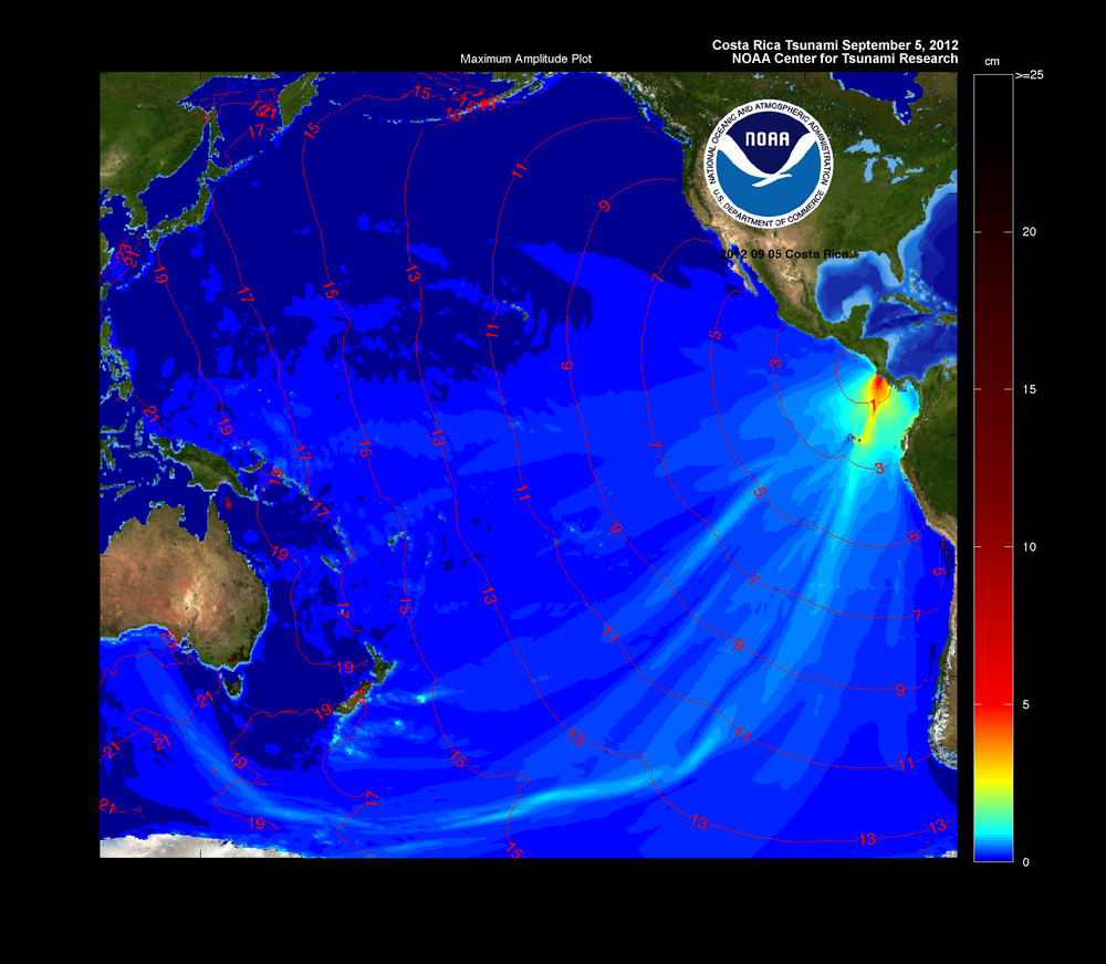
| September 5, 2012 | 04:42:10 AM | Off the coast of Costa Rica | 10.120N, 85.347E, 40.8 km | 7.6 Magnitude | 76% Waning Gibbous Lunation 1109 | No tsunami for Hawaii expected. usc000cfsd. PMEL Forecast Model. |
| August 31, 2012 | 02:47:34 AM | Philippine Island Region | 10.838N, 126.704E, 34.9 km | 7.6 Magnitude | 99% Waxing Full Moon 14 days, 17 hours, 14 minutes Lunation 1109 | Tsunami watch issued at 02:57 AM. Tsunami watch cancelled at 03:31 AM. usc000cc5m. |
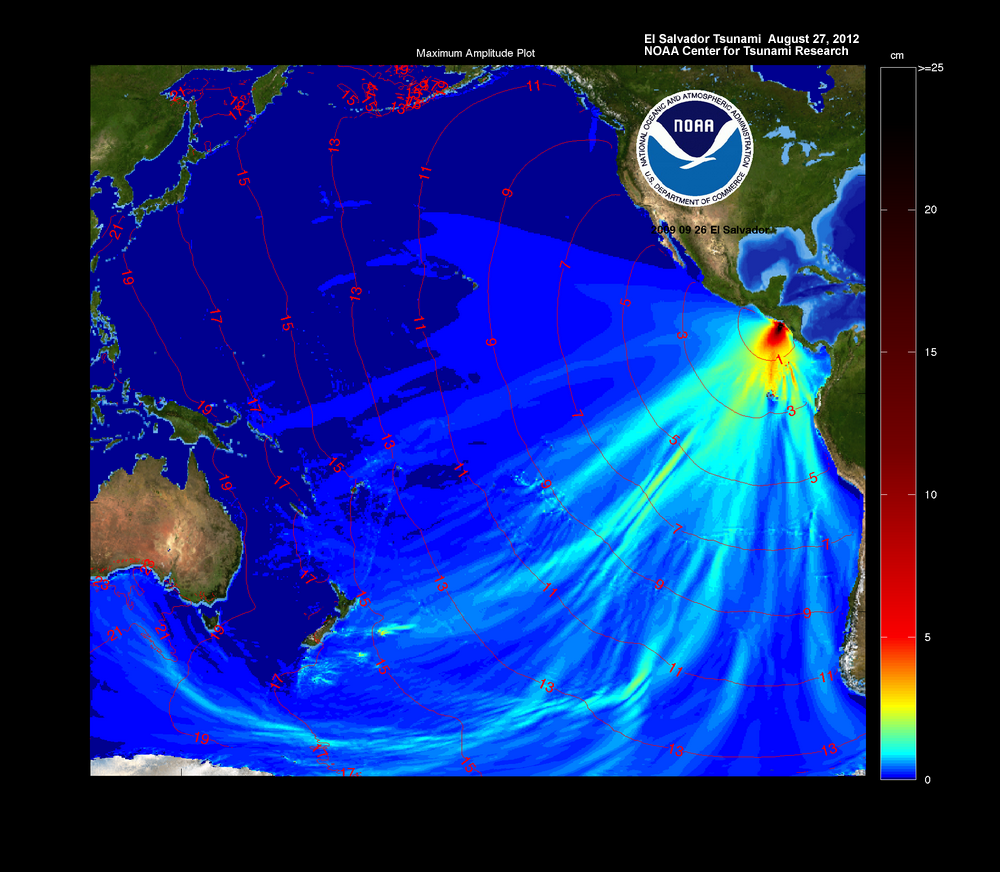
| August 26, 2012 | 06:37:20 PM | Off Coast of Central America | 12.278N, 88.528W, 20.3 km | 7.3 Magnitude | 78% Waning Crescent Lunation 1109 | No tsunami expected. usc000c7yw. PMEL Forecast Model. |
| August 26, 2012 | 05:05:37 AM | Northern Molucca Sea | 2.197N, 126.835W, 91.9 km | 6.7 Magnitude | 72% Waxing Gibbous Lunation 1109 | No tsunami expected. usc000c76x. |
| August 25, 2012 | 02:25:55 AM | Off the Kau Coast of the Big Island | 19.013N, 155.424W, 38.4 km | 3.9 Magnitude | 71% Waxing Gibbous Lunation 1109 | No tsunami expected. hv60387251. |
| August 13, 2012 | 04:59:42 PM | Sea of Okhotsk | 49.784N, 145.126E, 625.9 km | 7.2 Magnitude | 13% Waning Crescent Lunation 1108 | No tsunami expected. usc000bz29 |
| July 28, 2012 | 10:03:56 AM | New Ireland Region P.N.G | 4.655S, 153.159E, 41.2 km | 6.5 Magnitude | 48% Waxing Gibbous Lunation 1108 | No tsunami expected. usb000bid9. |
| July 25, 2012 | 01:20:27 AM | Solomon Islands | 9.721S, 159.730E, 22.9 km | 6.5 Magnitude | 39% Waxing Crescent Lunation 1108 | No tsunami expected. usb000bfq0. |
| June 15, 2012 | 02:18:34 PM | In the Hualalai Region of the Big Island | 19.873N, 156.000W, 39.4 km | 3.8 Magnitude | 11% Waning Crescent Lunation 1106 | No tsunami expected. hv60359516 |
| June 3, 2012 | 05:15:24 PM | South of Panama | 5.507N, 82.457W, 5.9 km | 6.4 Magnitude | 99% Waxing Full Moon 14 days, 9 hours, 11 minutes Lunation 1106 | No tsunami expected. usb000a66u. |
| May 23, 2012 | 03:44 am | In the deep ocean off the Kona Coast of the Big Island | 19.0N, 157.0W | 3.8 Magnitude | 6% Waxing Crescent Lunation 1106 | No tsunami expected. hv60348331. Star-Advertiser. |
| May 17, 2012 | 04:00:41 pm | Off Coast of Southern Chile | 44.594S, 80.073W, 10 km | 6.2 Magnitude | 7% Waning Crescent Lunation 1105 | No tsunami expected. usb0009sgu. |
| April 28, 2012 | 12:08:07 am | Tonga Islands | 18.643S, 174.725W, 129.4 km | 6.6 Magnitude | 40% Waxing Crescent Lunation 1105 | No tsunami expected. usc0009e33. |
| April 20, 2012 | 3:16:52 pm | Irian Jaya Region, Indonesia | 1.603S, 134.274E, 16 km | 6.6 Magnitude | 0% New Moon 29 days, 7 hours, 7 minutes Lunation 1104 | No tsunami expected. usc00098nl. |
| April 17, 2012 | 9:13:50 pm | Eastern New Guinea, P.N.G. | 5.474S, 147.097E, 208.2 km | 6.7 Magnitude | 14% Waning Crescent Lunation 1104 | No tsunami expected. usc00095c9. |
| April 17, 2012 | 5:50:16 pm | Offshore Valparaiso, Chile | 32.701S, 71.484W, 37 km | 6.7 Magnitude | 14% Waning Crescent Lunation 1104 | No tsunami expected. usc00095a2. |
| April 14, 2012 | 12:05:26 pm | Vanuatu Islands | 18.998S, 168.771E, 8.7 km | 6.5 Magnitude | 34% Waning Crescent Lunation 1104 | No tsunami expected. usc00093vj. |
| April 11, 2012 | 09:15:48 pm | Baja California, Mexico | 28.790N, 113.142W, 10.3 km | 6.9 Magnitude | 62% Waning Gibbous Lunation 1104 | No tsunami expected. usc00091a1. |
| April 11, 2012 | 12:55:10 pm | Michoacan, Mexico | 18.272N, 102.732W, 20 km | 6.5 Magnitude | 66% Waning Gibbous Lunation 1104 | No tsunami expected. usc00090z0. |
| March 25, 2012 | 12:37:06 pm | Maule, Chile | 35.183S, 71.792W, 34.8 km | 7.1 Magnitude | 9% Waxing Crescent Lunation 1104 | No tsunami expected. usc0008pwq. |
| March 24, 2012 | 10:47:15 am | In the Hilo Region of the Big Island | 19.863N, 155.133W, 43.2 km | 4.9 Magnitude | 4% Waxing Crescent Lunation 1104 | No tsunami expected. hv60326516. |
| March 21, 2012 | 12:15:05 pm | New Guinea, Papua New Guinea | 6.244S, 145.959E, 105.9 km | 6.7 Magnitude | 0% New Moon 28 days, 21 hours, 31 minutes Lunation 1103 | No tsunami expected. usc0008mye. |
| March 20, 2012 | 08:02:48 am | Oaxaca, Mexico | 16.662N, 98.188W, 20 km | 7.4 Magnitude | 3% Waning Crescent Lunation 1103 | No tsunami expected. usc0008m6h. |
| March 13, 2012 | 11:08:37 pm | Off East cost of Honshu | 40.899N, 144.923E, 26.6 km | 6.9 Magnitude | 57% Waning Gibbous Lunation 1103 | No tsunami expected. usb0008gs0. |
| March 8, 2012 | 9:09:53 pm | Vanuatu | 19.115S, 169.643E, 31.7km | 6.7 Magnitude | 98% Waning Gibbous Lunation 1103 | No tsunami expected. usb0008e4z. |
| March 3, 2012 | 3:19:55 am | Southeast of Loyalty Islands | 22.157S, 170.317E, 15.2km | 6.6 Magnitude | 72% Waxing Gibbous Lunation 1103 | No tsunami expected. usb0008age. |
| February 24, 2012 | 3:52:45 am | In The Summit Region Of Kilauea Volcano | 19.438N, 155.309W, 5.7km | 4.3 Magnitude | 6% Waxing Crescent Lunation 1103 | No tsunami expected. hv60314266. Star-Advertiser Article 1. |
| February 23, 2012 | 9:02:24 pm | In The Summit Region Of Kilauea Volcano | 19.436N, 155.314W, 5.2km | 4.3 Magnitude | 1% Waxing Crescent Lunation 1103 | No tsunami expected. hv60313901. Star-Advertiser Article 1. Star-Advertiser Article 2. |
| February 13, 2012 | 10:19:58 pm | Soloman Islands | 10.387S, 161.262E, 54.7km | 6.4 Magnitude | 54% Waning Quarter Lunation 1102 | No tsunami expected. usb000803b. |
| February 5, 2012 | 5:49:16 pm | Cebu, Philippines | 9.964N, 123.246E, 11km | 6.7 Magnitude | 91% Waxing Gibbous Lunation 1102 | No tsunami expected. usb0007wgq. |
| January 22, 2012 | 4:45:33 pm | On the South Flank of Kilauea Volcano Hawaii | 19.325N, 155.134W, 8.39 km | 3.1 Magnitude | 0% New Moon 29 days, 8 hours, 5 minutes Lunation 1101 | No tsunami expected. hv60302551. |
| January 22, 2012 | 4:36:32 pm | 10 Miles WSW OF Kalapana, Hawaii | 19.321N, 155.121W, 8.5 km | 4.7 Magnitude | 0% New Moon 29 days, 7 hours, 56 minutes Lunation 1101 | No tsunami expected. hv60302526. |
| January 8, 2012 | 6:07:16 pm | Santa Cruz Islands | 10.557S, 165.160E, 38.9 km | 6.6 Magnitude | 99% Waxing Gibbous Lunation 1101 | No tsunami expected. usc0007hrv. |
| December 31, 2011 | 7:27:54 pm | Izu Islands, Japan region | 31.416N, 138.6155E, 348.5km | 6.8 Magnitude | 49% Waxing Quarter Lunation 1101 | No tsunami expected. usc0007fbh. |
| December 13, 2011 | 7:04:47 pm | Eastern New Guinea Reg., P.N.G. | 7.518S, 146.767W, 121.2km | 7.1 Magnitude | 86% Waning Gibbous Lunation 1100 | No tsunami expected. usc00076e5. |
| December 10, 2011 | 3:47:26 pm | Guerrero Mexico | 18.038N, 99.796W, 64.9 km | 6.5 Magnitude | 99% Waning Gibbous Lunation 1100 | No tsunami expected. usc000753u. |
| November 22, 2011 | 8:48:17 am | Central Bolivia | 15.359S, 65.125W, 556.7 km | 6.6 Magnitude | 8% Waning Crescent Lunation 1099 | No tsunami expected. usc0006w6e. |
| November 20, 2011 | 10:17:21 pm | In the Saddle region of the Big Island | 19.53N, 155.64W, 10 km | 3.9 Magnitude | 20% Waning Crescent Lunation 1099 | No tsunami expected. us2001tmbd. |
| November 13, 2011 | 06:05:12 pm | Southern Molucca Sea | 0.954S, 126.864E, 19.4 km | 6.3 Magnitude | 89% Waning Gibbous Lunation 1099 | No tsunami expected. usc0006rlp |
| November 7, 2011 | 4:59:06 pm | Northeast of Taiwan | 27.291N, 125.868E, 209.5 km | 6.9 Magnitude | 93% Waxing Gibbous Lunation 1099 | No tsunami expected. usb0006lpm. |
| October 31, 2011 | 2:32:00 am | Revilla Gigedo Islands Region | 19.891N, 109.216W, 5 km | 6.3 Magnitude | 27% Waxing Crescent Lunation 1099 | No tsunami expected. usb0006hfg. |
| October 28, 2011 | 8:54:33 am | Near Coast of Central Peru | 14.515S, 76.009W, 23.9 km | 6.9 Magnitude | 5% Waxing Crescent Lunation 1099 | No tsunami expected. usb0006fv2. |
| October 21, 2011 | 7:57:16 am | Kermadec Islands | 29.998S, 176.183W, 32.9 km | 7.3 Magnitude | 32% Waning Crescent Lunation 1098 | No tsunami expected. usb0006b6p |
| October 19, 2011 | 2:10:04 pm | Waikoloa, Big Island | 19.883N, 155.532W, 18.8 km | 4.5 Magnitude | 51% Waning Quarter Lunation 1098 | No tsunami expected. hv60276536 Star-Advertiser article |
| October 13, 2011 | 4:35:15 pm | Eastern New Guinea Region | 6.626S, 147.927E, 45.4km | 6.7 Magnitude | 96% Waning Gibbous Lunation 1098 | No tsunami expected. usc00069ba |
| September 22, 2011 | 1:10:46 pm | Samoa Islands Region | 16.99S, 172.77W, 35 km | 4.9 Magnitude | 30% Waning Cresent Lunation 1097 | No tsunami expected. us2011rcbm |
| September 16, 2011 | 9:26:41 am | Off East Coast of Honshu, Japan | 40.303N, 142.801E, 38.4 km | 6.7 Magnitude | 83% Waning Gibbous Lunation 1097 | No tsunami expected. usc0005vv7 |
| September 9, 2011 | 9:41:34 pm | Vancouver Island, Canada | 49.493N, 126.967W, 23 km | 6.4 Magnitude | 95% Waxing Gibbous Lunation 1097 | No tsunami expected. usc0005rsj |
| September 3, 2011 | 12:46:36 pm | Vanuatu | 20.585S, 169.696E, 132.4 km | 7.0 Magnitude | 41% Waxing Crescent Lunation 1097 | No tsunami expected. usc0005ntq |
| September 2, 2011 | 1:05:54 am | Fox Islands, Aleution Islands, Alaska | 52.185N, 171.684W, 35.5 km | 7.1 Magnitude | 25% Waxing Crescent Lunation 1097 | No tsunami expected. usc0005n83 |
| August 24, 2011 | 7:46:11 am | Northern Peru | 7.644S, 74.506W, 145.1 km | 6.8 Magnitude | 22% Waning Crescent Lunation 1096 | No tsunami expected. usc0005j3l |
| August 20, 2011 | 8:19:24 am | Vanuatu | 18.287S, 168.132E, 28.5 km | 7.0 Magnitude | 60% Waning Gibbous Lunation 1096 | No tsunami expected. usc0005hbt |
| August 20, 2011 | 6:55:02 am | Vanuatu | 18.260S, 168.069E, 40.6 km | 7.1 Magnitude | 61% Waning Gibbous Lunation 1096 | No tsunami expected. usc0005h9f |
| August 19, 2011 | 7:36:32 am | Near The East Coast of Honshu, Japan | 37.673S, 141.716E, 43.6 km | 6.3 Magnitude | 70% Waning Gibbous Lunation 1096 | No tsunami expected. usc0005gmg |
| August 1, 2011 | 1:38:57 pm | Near North Coast of New Guinea, P.N.G. | 3.569S, 144.844E, 16.8 km | 6.8 Magnitude | 6% Waxing Crescent Lunation 1096 | No tsunami expected. usc0005706 |
| July 29, 2011 | 9:42:23 pm | South of Fiji Island | 23.651S, 179.822E, 521.7 km | 6.7 Magnitude | 0% New Moon 29 days, 1 hour, 9 minutes Lunation 1095 | No tsunami expected. usc00055wy |
| July 23, 2011 | 6:47 pm | Near East Coast of Honshu Japan | 38.9N, 142.2E, 40 km | 6.5 Magnitude | 40% Waning Crescent Lunation 1095 | No tsunami expected. |
| July 11, 2011 | 10:47 am | Negros, Philippines | 9.5N, 122E, 10 km | 6.6 Magnitude | 86% Waxing Gibbous Lunation 1095 | No tsunami expected. |
| July 10, 2011 | 2:57 pm | Near East Coast of Honshu Japan | 38.040N, 143.287E, 23 km | 7.0 Magnitude | 79% Waxing Gibbous Lunation 1095 | No tsunami expected. usc0004sg6 |
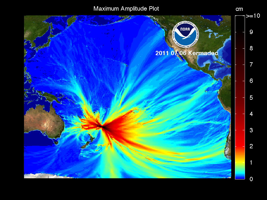
| July 6, 2011 | 9:09:16 am | Kermadec Islands | 29.312S, 176.204W, 20 km | 7.6 Magnitude | 33% Waxing Crescent Lunation 1095 | No tsunami expected. usc0004pbm. PMEL Forecast Model. |
| June 24, 2011 | 5:09:40 pm | Fox Islands, Aleutian Islands, Alaska | 52.008N, 171.859W, 62.6 km | 7.2 Magnitude | 34% Waning Crescent Lunation 1094 | No tsunami expected. usc0004f5m |
| June 22, 2011 | 11:50 am | Near East Coast of Honshu Japan | 39.9N, 142.5E | 6.7 Magnitude | 55% Waning Gibbous Lunation 1094 | No tsunami expected. |
| June 20, 2011 | 6:36 am | North Chile | 22S, 68.3W | 6.6 Magnitude | 75% Waning Gibbous Lunation 1094 | No tsunami expected. |
| June 15, 2011 | 2:04 pm | New Britain Region P.N.G. | 6.0S, 151.4E | 6.6 Moment | 99% Waning Gibbous Lunation 1094 | No tsunami expected. |
| June 5, 2011 | 2:04 am | West of Macquarie Island | 56.2S, 147.5E | 6.6 Magnitude | 14% Waxing Gibbous Lunation 1094 | No tsunami expected. |
| May 15, 2011 | 8:52 am | Solomon Islands | 6.1S, 154.4E | 6.6 Magnitude | 95% Waxing Gibbous Lunation 1093 | No tsunami expected. |
| May 9, 2011 | 10:55:09 pm | Loyalty Islands | 20.252S, 168.273E, 14.9 km | 6.8 Magnitude | 39% Waxing Crescent Lunation 1093 | No tsunami expected. usc0003ag4 |
| April 22, 2011 | 6:16:55 pm | Solomon Islands | 10.349S, 161.233E, 81.6 km | 6.9 Magnitude | 69% Waning Gibbous Lunation 1092 | No tsunami expected. usc0002xcx |
| April 18, 2011 | 3:03 am | South of Kermadec Islands | 34.3S, 179.9E, 90.7 km | 6.6 Magnitude | 99% Waning Gibbous Lunation 1092 | No tsunami expected. usc0002ty7 |
| April 11, 2011 | 10:16:13 pm | Near East Coast of Honshu, Japan | 37.007N, 140.477W, 10 km | 7.1 Magnitude | 59% Waxing Gibbous Lunation 1092 | No tsunami expected. usc0002n9v |
| April 7, 2011 | 4:32:41 am | Near East Coast of Honshu, Japan | 38.253N, 141.640W, 49 km | 7.1 Magnitude | 15% Waxing Crescent Lunation 1092 | No tsunami expected. usc0002ksa |
| March 27, 2011 | 12:23:58 pm | Near East Coast of Honshu, Japan | 38.40N, 142.10E, 17 km | 6.2 Magnitude | 35% Waning Crescent Lunation 1091 | No tsunami expected. NEIC |
| March 21, 2011 | 7:08:03 pm | Near East Coast of Honshu, Japan | 36.18N, 141.61E, 18 km | 5.3 Magnitude | 94% Waning Gibbous Lunation 1091 | No tsunami expected. NEIC |
| March 17, 2011 | 4:48:00 pm | Vanuatu | 17.339S, 167.743E, 15.2 km | 6.3 Magnitude | 98% Waxing Gibbous Lunation 1091 | No tsunami expected. NEIC |
| March 10, 2011 | 10:58:25 pm | Kilauea, Hawaii | 19.341N, 154.993W, 9.3 km | 4.3 Magnitude | 34% Waxing Crescent Lunation 1091 | No tsunami expected. HON The epicenter was near the edge of the earth as viewed from the moon. |
| March 10, 2011 | 07:46:23 pm | Near Honshu, Japan | 38.297N, 142.372E, 30 km | 9.0 Magnitude | 32% Waxing Crescent Lunation 1091 |
Great Tohoku quake. Major damage in Japan. Tsunami in Hawaii. 5.7 ft in Kahului Harbor. 7 ft on Maui.
USGS NEIC (WDCS-D).
PMEL Forecast Model.
Damage on Kauai. Maui and Kailua-Kona. Maui2. Lahaina and Maalaea Harbors. Maui4. Maui5. Kealakekua. West Hawaii. East Hawaii . Correlated with a solar CME. Amateur radio operations. |
| March 10, 2011 | 07:08:36 am | Bali Sea | 8.862S, 116.765E, 508.1 km | 6.5 Magnitude | 28% Waxing Crescent Lunation 1091 | No tsunami expected. USGS NEIC (WDCS-D) |
| March 9, 2011 | 11:24:51 pm | Papua New Guinea | 6.022S, 149.659E, 29 km | 6.5 Magnitude | 21% Waxing Crescent Lunation 1091 | No tsunami expected. USGS NEIC (WDCS-D) |
| March 8, 2011 | 04:45:20 pm | Near Honshu, Japan | 38.424N, 142.836E, 32 km | 7.2 Magnitude | 15% Waxing Crescent Lunation 1091 | No tsunami expected in Hawaii. First of a series of Honshu quakes. USGS NEIC (WDCS-D) |
| March 6, 2011 | 02:09:38 pm | Solomon Islands | 10.314S, 160.739E, 37.9 km | 6.5 Magnitude | 4% Waxing Crescent Lunation 1091 | No tsunami expected. USGS NEIC (WDCS-D) |
| February 24, 2011 | 02:12:33 pm | In the Kaiwi Channel, between Oahu and Molokai | 21.180N, 157.550W, 19 km | 3.6 Magnitude | 49% Last Quarter Lunation 1090 | No tsunami expected. us201huad. Possible causes. |
| February 14, 2011 | 05:40:09 am | Offshore Maule, Chile | 35.37S, 72.84W, 21 km | 6.7 Magnitude | 82% Waxing Gibbous Lunation 1090 | No tsunami expected. USGS NEIC (WDCS-D) Event ID us2011hian |
| February 11, 2011 | 10:00:31 am | Near coast of Central Chile | 36.344S, 72.959W, 18 km | 6.8 Magnitude | 55% Waxing Gibbous Lunation 1090 | No tsunami. USGS Catalog The epicenter was near the edge of the earth as viewed from the moon. |
| January 15, 2011 | 11:27:32 am | In the Waikoloa region of the Big Island | 19.836N, 155.602W, 16 km | 3.5 Magnitude | 81% Waxing Gibbous Lunation 1089 | No tsunami expected. HVO Catalog |
| January 2, 2011 | 10:20:18 am | Araucania, Chile | 38.354S, 73.275W, 25.1 km | 7.1 Magnitude | 2% Waning Crescent Lunation 1088 | No tsunami expected. USGS Catalog |
| December 25, 2010 | 3:16:36 am | Vanuatu | 19.775S, 167.895E, 12.3 km | 7.3 Magnitude | 78% Waxing Gibbous Lunation 1088 | No tsunami expected, but sea level changes expected. USGS Catalog Star Advertiser Article |
| December 22, 2010 | 11:49:39 am | Bonin Islands, Japan Region | 26.780N, 143.635E, 11.0 km | 6.3 Magnitude | 95% Waning Gibbous Lunation 1088 | No tsunami expected. USGS Catalog |
| December 21, 2010 | 7:19:41 am | Bonin Islands, Japan Region | 26.892N, 143.726E, 14 km | 7.4 Magnitude | 99% Waning Gibbous Lunation 1088 | No tsunami expected. USGS Catalog |
| December 18, 2010 | 10:11:18 am | Southwest of Kahoolawe | 20.387N, 156.759W, 10 km | 3.8 Magnitude | 92% Waxing Gibbous Lunation 1088 | No tsunami expected. USGS Catalog |
| July 18, 2010 | 3:27:56 pm | Just south of Oahu | 21.1N, 157.8W, 10 km | 6.3 Magnitude | 56% Waxing Crescent Lunation 1083 | No tsunami expected. USGS Catalog |
| April 29, 2010 | 1:11:44 pm | Bearing Sea, Alaska | 60.644N, 177.901W, 15.1 km | 6.3 Magnitude | 97% Waxing Gibbous Lunation 1080 | No tsunami expected. USGS Catalog |
| April 25, 2010 | 5:00 pm | Southeast of Taiwan | 22.4S, 124.0E | 6.5 Moment | 92% Waxing Gibbous Lunation 1080 | No tsunami expected. |
| April 10, 2010 | 11:41 pm | Solomon Islands | 11.0S, 161.1E | 7.0 Moment | 9% Waning Crescent Lunation 1079 | No tsunami expected. |
| April 6, 2010 | 12:40:42 pm | Baja California, Mexico | 32.259N, 115.287W, 10 km | 7.2 Magnitude | 44% Waning Crescent Lunation 1079 | No tsunami expected. Star Bulletin article. |
| March 16, 2010 | 1:04:00 am | Greater Los Angles Area, California | 33.992N, 118.082W, 18.9 km | 7.2 Magnitude | 0% New Moon 0 days, 12 hours, 56 minutes Lunation 1079 | No tsunami expected. |
| March 15, 2010 | 4:22 pm | Near coast of central Chile | 36.2S, 73.5W | 6.7 Magnitude | 0% New Moon 0 days, 4 hours, 56 minutes Lunation 1079 | No tsunami expected. |
| March 8, 2010 | 6:30 pm | Hamakua Coast region of the Big Island | 19.9N, 155.4W | 5.0 Magnitude | 54% Waning Cresent Lunation 1078 | No tsunami expected. Star Bulletin article. |
| February 26, 2010 | 8:34:14 pm | Offshore Maule, Chile | 35.909S, 72.733W, 35 km | 8.8 Magnitude | 96% Waxing Gibbous Lunation 1078s |
Massive destruction in Chile. A series of 3 foot Hawaii tsunamis was generated. USGS event ID us2010tfan.
USGS Report.
PMEL Forecast Models.
Honolulu Star-Bulletin Saturday Honolulu Star-Bulletin Sunday Honolulu Advertiser Saturday Honolulu Advertiser Sunday Amateur radio operations. |
| February 26, 2010 | 10:31:27 am | Ryukyu Islands, Japan | 25.902N, 128.417E, 22 km | 7.0 Magnitude | 95% Waxing Gibbous Lunation 1078 | No tsunami expected. USGS Report. |
| February 23, 2010 | 10:41:33 am | Offshore of the Kalapana region of Kilauea Volcano | 19.304N 154.921W 44.3 km | 3.5 Magnitude | 69% Waxing Gibbous Lunation 1078 | No tsunami expected. USGS Report. |
| January 12, 2010 | 11:53:10 am | 25 km (15 miles) WSW of Port-Au-Prince, Haiti | 8.443N, 72.571W, 13 km | 7.0 Magnitude | 5% Waning Crescent Lunation 1076 | Massive destruction and isolation in Haiti. No Hawaii tsunami was generated. USGS event ID us2010rja6. USGS Maps. |
| December 8, 2009 | 11:46 pm | Southeast of Loyalty Islands | 22.2S, 170.9E | 6.5 Moment | 45% Waning Quarter Lunation 1075 | Seismic information issued at 11:59 pm. No Hawaii tsunami was generated. |
| November 17, 2009 | 5:30:46 am | Queen Charlotte Islands Region | 52.080N, 131.512W, 10 km | 6.6 Magnitude | 1% Waxing Crescent Lunation 1075 | Seismic information issued at 5:44 am. No tsunami was generated. Hawaii tsunami watch cancelled at 6:09 am. |
| November 12, 2009 | 5:05:57 pm | Region Offshore Tarapaca, Chile | 19.385S, 70.266W, 28 km | 6.5 Magnitude | 14% Waning Crescent Lunation 1074 | No tsunami was generated. |
| October 22, 2009 | 11:13:50 pm | Loihi Seamount | 18.875N, 155.217E, 14.7 km | 4.1 Magnitude | 25% Waxing Crescent Lunation 1074 | Seismic information issued at 11:22 pm. No tsunami was generated. |
| October 7, 2009 | 10:29 pm | Vanuatu Islands | 13.2S, 166.E, 33 km | 7.0 Magnitude | 81% Waning Gibbous Lunation 1073 | Information only. |
| October 7, 2009/td> | 12:03 pm | Vanuatu Islands | 13.0S, 166.3E, 33 km | 7.8 Magnitude | 85% Waxing Gibbous Lunation 1073 | Tsunami watch cancelled at 2:19 pm. us2009mlcf |
| September 30, 2009 | 01:52:30 pm | Southern Sumatra, Indonesia | 2.497S, 101.540E, 15 km | 6.6 Magnitude | 95% Waxing Gibbous Lunation 1073 | 1,117 dead in Indonesia from the quake. No tsunami in Hawaii. us2009mebz |
| September 29, 2009 | 7:48:10 am | Samoa Islands | 15.509S, 172.034W, 18 km | 8.0 Magnitude | 81% Waxing Gibbous Lunation 1073 | us2009mdbi 186 killed by tsunami in Samoa, American Samoa and Tonga. Hawaii watch issued at 8:04 am and downgraded to an advisory at 10:23 am. Ocean level changes in Hawaii. Hawaii247.org article Wave in Keauhou Bay, Big Island Honolulu Advertiser article Star-Bulletin article Star-Bulletin article |
| August 9, 2009 | 12:55:55 am | Southeast of Honshu, Japan | 33.1N, 138.5E, 297 km | 6.9 Magnitude | 85% Waning Gibbous Lunation 1071 | No local tsunami. |
| July 14, 2009 | 11:22:32 pm | Off west coast of S. Island of New Zealand | 45.725S, 166.618E, 34 km | 7.8 Moment | 50% Waning Quarter Lunation 1070 | No local tsunami. Local sea level changes expected at 11:07 am. Star-Bulletin Article |
| April 6, 2009 | 6:24:34 pm | Kuril Islands | 46.088N, 151.498E, 34 km | 6.8 Moment | 93% Waxing Gibbous Lunation 1067 | No local tsunami. |
| March 19, 2009 | 8:17:40 am | Tonga Islands | 23.04S, 174.65W, 34 km | 7.6 Magnitude | 40% Waning Cresent Lunation 1066 | No local tsunami. ETA 2:36 PM. |
| August 13, 2008 | 1:08:43 am | 18 miles off Oahu | 21.533N, 158.491W, 16 km | 3.0 Magnitude | 88% Waxing Gibbous Lunation 1059 | No local tsunami. Star-Bulletin Article |
| Nov 14, 2007 | 5:40:53 am | Antofagasta, Chile | 22.189S, 69.843W, 60 km | 7.7 Magnitude | 90% Waning Gibbous Lunation 1050 | Alert posted 5:41 am. Advisory cancelled 6:56 am. ETA 7:36 PM. Star-Bulletin Article 6.2 and 6.8 aftershock. |
| Aug 16, 2007 | 1:40:57 pm | Pisco, Peru | 13.36S, 76.52W, 39 km | 8.0 Magnitude | 12% Waxing Crescent Lunation 1047 | Alert posted 2:20 pm. Advisory cancelled 4:10 pm. 27 inch tsunami in Hilo Harbor. 3 inches in Honolulu Harbor. Star-Bulletin Article |
| Apr 1, 2007 | 10:39:56 am | Soloman Islands | 8.453S, 156.957E, 10.0 km | 8.0 Magnitude | 99% Waning Gibbous Lunation 1042 | Alert posted 10:57 am. Watch cancelled 12:41 pm. |
| Jan 12, 2007 | 6:23:20 pm | Kuril Islands | 46.272N, 154.455E, 10.0 km | 8.2 Magnitude | 34% Waning Crescent Lunation 1039 | Watch posted 6:37 pm. Watch cancelled 9:33 pm. 11 inch tsunami recorded in Haleiwa Harbor at 12:55 am. 5.51 inch wave recorded in Kahului Harbor at 12:49 am. Kuril Island quake us2007xmae |
| Nov 23, 2006 | 9:20 am | Puako, HI | 19.899N, 155.956W, 12.6 km | 5.0 Magnitude | 8% Waxing Crescent Lunation 1038 | No destructive tsunami generated. |
| Nov 15, 2006 | 1:14 am | Kuril Islands | 46.7N, 153.5E, 28.5 km | 8.3 Magnitude | 25% Waning Crescent Lunation 1037 | Four PTWC bulletins issued. Tsunami watch cancelled at 4:48 am. Sixteen inch non-destructive tsunami recorded in Japan. Wave arrival time was estimated at 7:17 am. Advisory issued for potential sea level changes near shores and harbors issued approx 6:58 am. Unusual wave action approximately one foot high observed in Haleiwa Harbor around 7:55 am. Haunama Bay closed. usvcam |
| Nov 7, 2006 | 7:39 am | New Britian Region Papua, New Guinea | 6.6S, 151.2EW, 38.9 km | 6.7 Magnitude | 93% Waning Gibbous Lunation 1037 | Tsunami watch cancelled 11:09 am. |
| Oct 15, 2006 | 7:07:49 am | Kiholo, 6 miles SW from Puako, HI | 19.878N, 155.935W, 38.9 km | 6.7 Magnitude | 33% Waxing Crescent Lunation 1036 | One PTWC bulletin issued at 7:12 AM. 15 Seconds Strong earthquake damages Kona region. Power stopped at most of the Big Island, most of Maui, most of Oahu. Three inch non-destructive tsunami recorded at Kawaihae Harbor. Disaster plans show a shortage of sirens Crescent moon directly over Hawaii ustwbh |
| August 28, 2006 | 08:09:56 pm | Between Oahu and Molokai | 6.2 mi | 3.7 Magnitude | 24% Waxing Crescent Lunation 1035 | Equipment cited in quake reporting error Location revised. Quake off Molokai measured 3.7 Earthquake off Kohala rattles isle residents Quake felt on Maui and Oahu. |
| July 27, 2006 | 10:03 am | Off the southern coast of Kahoolawe | 19 mi | 4.4 Magnitude | 6% Waxing Crescent Lunation 1034 | One PTWC bulletin issued at 7:12 AM. 'Light' quake rattles some local nerves Quake felt on Maui and Oahu. |
| May 3, 2006 | 5:27 am | Tonga Islands | 20.13S, 174.16W, 55 km | 7.8 Moment, 7.7 Richter | 34% Waxing Crescent Lunation 1031 | ETA 11:33 am. Three PTWC bulletins issued. #2 Advisory update at 06:34 am, with corrected ETA. #3 Watch cancelled 07:39 am. Small tsunami exposes glitches. Confusion regarding the closing of schools along the inundation zones. Eight inch tsunami received. Note that the earthquake was preceeded by a 4.5 earthquake 35 km deep 13.5 hours earlier, and 17 4.4-6.0 aftershocks within 34 hours. |
| July 15, 2005 | 5:48 am | 30 miles north-northeast of Ookala, NW of Hilo | 5 mi | 5.2 Magnitude | 60% Waxing Gibbous Lunation 1021 | 5.2 earthquake rattles Big Island Quake felt on Big Island, and Maui. |
| December 25, 2006 | 2:58:53 pm | Off the West coast of Northern Sumatra | 3.316N 95.854W 30km | 9.1 Magnitude | 99% Waxing Gibbous Lunation 1014 | No tsunami alert in Hawaii. us2004slav More than 283,100 killed. |
| Sept 25, 2003 | 9:50:06 am | Eastern Honshu, Japan | 41.775N, 143.904E, 27 km | 8.3 Magnitude | 0% New Moon 29 days, 4 hours, 12 minutes Lunation 998 | uszdap ETA 5:01 pm. Four PTWC bulletins issued. #2 Advisory update at 10:27, with corrected ETA. #3 Watch issued 11:11 am. #4 Watch cancelled 12:14 pm. Tsunami affects Oahu bus strike Felt strongly in much of Hokkaido. A tsunami generated with an estimated wave height of 1.0 meter along the southeastern coast of Hokkaido. |
| June 23, 2001 | 10:33:14 am | Off Peru | 16.1S, 73.3W, 33 km | 8.4 | 7% Waxing Crescent Lunation 971 | Info activated in am. Cancelled in pm. USGS NEIC |
| Jan 13, 2001 | 7:33:32 am | Off El Salvador | 13.1N, 88.6W, 60 km | 7.8 | 79% Waxing Gibbous Lunation 965 | Info activated at 8:00 am, ETA 6:06 pm, Cancelled at 12:29 pm. VOAD communications demonstration in progress. USGS NEIC |
| Nov 15, 2000 | 6:54:56 pm | New Ireland Islands Region | 3.958S, 152.268E, 33 km | 8.1 | 76% Waning Gibbous Lunation 963 | Info activated by 8:00 pm; ETA 3:30 am; Cancelled at 10:30 pm. OCDA/EARC meeting in progress. USGS NEIC |
| March 24, 1998 | 5:12:25 pm | Balleny Islands Region | 63.2S, 150.8E, 33km | 8.1 | 12% Waning Crescent Lunation 930 | Watch activated at 9:49 pm; ETA 7:09 am; Cancelled at 11:00 pm USGS NEIC |
| Dec 5, 1997 | 1:25:54 am | Kamchatka | 54.8N, 162.0E, 33km | 7.8 | 30% Waxing Crescent Lunation 927 | Watch activated at 2:10 am; ETA 7:12 am; Cancelled at 3:51 am USGS NEIC |
| Apr 21, 1997 | 2:02 am | Santa Cruz Islands | 12.5S, 166.7E, 33km | 7.8 | 98% Waxing Gibbous Lunation 919 | Watch cancelled at 4:47 am More |
| Nov 12, 1996 | 7:00 am | Peru | 15.0S, 75.7W, 33km | 7.7 | 2% Waxing Crescent Lunation 914 | Watch cancelled at 7:01 am |
| Jun 10, 1996 | 5:24 am | Andreanof Islands, Alaska | 51.5N, 176.8W, 26.3km | 7.9 | 27% Waning Crescent Lunation 908 | Watch cancelled; 10 inches; June 11, 1996 |
| Jun 9, 1996 | 6:03 pm | Alaska | 51.5N, 177.6W, 33km | 7.9 | 31% Waning Crescent Lunation 908 | Watch cancelled; 3 feet; June 10, 1996 |
| Jan 16, 1995 | 10:46:52 am | Kobe, Japan | 34.6N, 135E, 21.9km | 7.3 | 99% Waxing Gibbous Lunation 891 | No tsunami; More More Japan time was Jan 17, 1995; 5.46 am USGS NEIC |
| Oct 4, 1994 | 3.22 am; | Hokkaido, Japan | 43.7N, 147.3E, 14km | 8.2 | 0% New Moon 28 days, 19 hours, 51 minutes Lunation 887 | Tsunami warning at 4:25 am; 6:30 am sirens;1 ft in Hilo Bay at 11:00 am; Cancelled at 12:10 pm More |
| Jan 17, 1994 | 2:30:55 am | Northridge, California | 34.2N, 118.5W, 18.3km | 6.7 | 28% Waxing Crescent Lunation 879 | No tsunami; Article More USGS NEIC |
| Oct 17, 1989 | 2:04:15 pm | Loma Prieta, California | 37.0N, 121.9E, 17.29km | 6.9 | 89% Waning Gibbous Lunation 826 | No tsunami USGS NEIC |
| May 7, 1986 | 12:47 pm | Andreanof Islands, Alaska | 51.5N, 174.8W, 33km | 7.9 | 0% New Moon 28 days, 15 hours, 42 minutes Lunation 783 | Tsunami Alert; Massive traffic jams More USGS NEIC |
| Nov 29, 1975 | 4:47:40 am | Big Island | 19.3N, 155.0W, 5km | 7.2 | 15% Waning Crescent Lunation 654 | 48 foot destructive tsunami caused by drop in section of Hilina Pali; two lives lost Article USGS NEIC |
| Apr 26, 1973 | 10:26:30 am | Big Island | 19.9N, 155.1W, 50km | 6.1 | 39% Waning Crescent Lunation 622 | No tsunami; More USGS NEIC |
| Mar 28, 1964 | 5:36 pm | Prince William Sound, Alaska | 61.0N, 147.7W, 33km | 8.4 | 98% Waning Gibbous Lunation 510 | Tsunami. 5.4 hour travel time. 3.0 meter runup at Hilo. USGS NEIC |
| May 22, 1960 | 9:11 am | South Central Chile | 39.5S, 74.5W, 33km | 9.5 | 6% Waning Crescent Lunation 462 | Great Chilean quake. Destructive tsunami. Wave travel time was 14.8 hours. 61 people died. 10.7 meter runup. Numeric Models and Animation USGS NEIC |
| March 9, 1957 | 4:22:31 am | Andreanof Islands, Aleutian Islands, Alaska | 51.5N, 175.7W, 33km | 8.6 | 51% Waxing Quarter Lunation 423 | Destructive tsunami. 16 meter runup. USGS NEIC |
| November 4, 1952 | 6:58:26 am | Kamchatka Peninsula, Russia | 52.8N, 159.5E, 30km | 9.0 | 91% Waning Gibbous Lunation 369 | Destructive tsunami. 12 ft runup at Cocoanut Island. USGS NEIC |
| Apr 1, 1946 | 2:28:56 am | Unimak Island, Aleutian Islands, Alaska | 8.1 | 0% New Moon 28 days, 18 hours, 18 minutes Lunation 287 | Destructive tsunami. 4.9 hour travel time. 12 meter runup at Pololu Valley, Island of Hawaii. USGS NEIC | |
| Dec 15, 1811 | 10:15 pm | New Madrid Fault | 8.1 | 0% New Moon 13 hours 23 minutes | First of four major quakes, Last one caused massive destruction in New Madrid, Missouri USGS NEIC | |
| Jan 26, 1700 | 6:00 pm | Cascadia | ~9 | 39% Waxing Crescent | Cascadia Megathrust quake. Wikipedia article USGS NEIC |
Other notable Pacific Rim earthquakes were also included for information for
comparison.
Researchers try to map out Hawaii's cataclysmic future
Hawaii's tsunami danger is real, experts say
Earthquake-Tsunami FAQ
Tsunami Information Resource
Future Hilo Tsunami Museum
More
Big Island Slumping
Floods
- August 24-, 2015
Statewide flash flood watch, brown water advisory
Kilo predicted to pass by, but the rain has hit
Power in Hawaii Kai restored after two hours
Rains close Maui, Molokai, Kona schools
Monday Star-Advertisers late due to press issues and weather
Heavy rains and high winds state-wide due to excess moisture from TD Kilo. Massive sewer spill near Waikki. Massive sewage spill shuts down most of Waikiki Beach
- January 2-3, 2015 Heavy rains and high winds state-wide due to passing winter cold front. Road closures, downed utility poles, power outages and other storm effects. Final article. Power outages. Big Island road closures and power outages.
- July 19-21, 2014 Heavy rains state-wide due to remnants of Tropical Storm Wali. Flash flood warning. Road closures and other storm effects. Kaneohe sewer overflows. Heavy rains state-wide due to remnants of Tropical Storm Wali. Brown water alert on Maui.
- February 21-23, 2013 Heavy rains on Kauai, Oahu, Maui and Hawaii County. Flash flood warning lifted on Oahu, but more rains may come. Bad weather persists over Hawaii County. Kauai hiker swept out to sea. Kauai hiker swept out to sea recovered.
- January 27-29, 2013 Heavy rains on Kauai, Oahu and Maui County. Boulders fall on Kalihi Valley and Hawaii Kai homes.
- November 23, 2012 Isolated thunderstorm in Central Oahu causes localized flooding. Quarter-inch sized hail fell in Pearl City. Roof collapses at Farrington High School auditorium. Main story.
- March 3-10, 2012 Isolated thunderstorms from Kauai to Maui causes localized flooding and wind damage. Flash floods on Kauai. Waterspouts spotted on radar from north of Kahului to southwest of Honolulu. Intense lightning and thunder in Kaimuki. In the 24-hour period ending at 11 p.m. Monday, almost 17 inches of rain fell on Hanalei. Mudlside on Diamond Head Road. Main story. Kauai story. Lighning damage. Mudslide on Diamond Head Road and near Halona Blowhole. Hail in Niu Valley, Aina Haina and Waimanalo. Brown water alert. Kauai schools closed due to closed roads and flooding. Hanalei School; Kilauea Elementary School; Kapaa Elementary School; Kapaa Middle School; Kapaa High School; Kamehameha Schools' Anahola Preschool; and Island School. Tuesday story. Wednesday story. Sweetie Pacarro's home hit by lightning. 36 ft catamaran sunk in Keehi Lagoon after lightning strike. Grape-sized hail in Niu Valley, Aina Haina and Waimanalo about 9:30 am Tuesday. Thursday story. Heavy rains on Kauai, Oahu, Maui lead to flood damage Friday. Lightning and 2-inch hail before dawn in Kaneohe. Flooding on Kauai. Friday premium article. Tornado in Lanikai and Enchated Lakes.
- December 10, 2011 Isolated thunderstorms throughout the state causes localized flooding and wind damage. Lightning from Kaimuki through Pearl City. Main story.
- June 4, 2011
Unstable weather causes state-wide flash flood watch
and fierce lightning storm over Kahaluu.
Rich KH6DAD reports that his sons counted over 500 lightning flashes between
7:30 pm and 8:00 pm.
NWS estimates more than 13,000 lightning strikes between 3 pm and 3 am.
Kamehameha Highway was closed from Kahaluu to Kaawa,
with multiple reports of flooding and ponding.
Main story. Winter storm conditions drop snow on the Big Island summits, unusual for June. Lightning knocks out pioneering Hawaii telescope on Mauna Kea. - May 2, 2011
Storm front moving from the Big Island westward to Oahu.
Hail in Olinda, Maui and Mauna Kea.
60,000 customers lose power.
Two waterspouts offshore of downtown Honolulu.
Fierce lightning storm.
Main story. 40,000 lightning strikes estimated. Lightning struck the aina about 40,000 times
- March 4, 2011
Cold front brings high winds, rain, thunder and lightning.
Toppled utility poles in Kapolei and Ewa Beach leads to power outages.
KHNL-TV and KFVE-TV off the air for more than six hours.
Main story. HECU union workers on strike. Coping with outage. HECO strike.
- February 23, 2011
Spectacular lightning. Lightning damage, Hail. Unstable air mass.
Main story. Doppler radar at 4:49 pm showing rain cell over Kailua
- January 18, 2011
Heavy rains overwhelm Waimanalo Gulch dump site.
Main story.
- January 16, 2011
Flash flood warning issued for Kauai, watch for Oahu
Main story.
- January 13, 2011
Flooding on Kauai, Oahu, Maui and Big Island
Main story.
Waste water discharge from Waimanalo Gulch.
Rain dislodges medical wastes.
Preparations on Maui.
Heavy rains on Maui.
Roads reopened.
Heavy flooding on Maui.
Heavy flooding on Maui.
Boil water advisory cancelled.
Flooding clean up continues
- December 26, 2010
City urges drivers to stay off roads; Flash flood watch remains in effect.
Main story.
Heavy flooding on Maui.
Clean up mode.
Weather conditions improving.
- December 19, 2010
Heavy flooding on Oahu. 5.3 inches in 24 hours. 4 ft wide sinkhole opens on Oahu ave.
4,000 gallons of waste water overflows a broken sewer pipe on 9th Ave in Palolo Valley into
Palolo Stream.
45 stores in Ala Moana Shopping Center affected by a storm-caused fire at the Makaloa Substation and
closed until noon on the Sunday before Christmas.
Main story.
HFD responds to 53 incidents.
Rains close City Hall, zoo, golf courses, Haunama Bay.
Ala Moana Shopping Center affected by power outage.
Ala Moana Shopping Center loses power four times during the holiday shopping season.
Honolulu Star-Advertiser delivery may be affected.
- December 11 - 14, 2008
Major flooding on Kauai and Oahu due to heavy winter storm. Maui also received heavy rains.
Flooding near H1/H2 merge affected the H1 zipper lane. Flooding on H1 near north/south interchange. A large tree fell on Kaipapau Bridge in Hau'ula this morning, forcing the closure of Kamehameha Highway. Also closed were the Karsten Thot Bridge in both directions due to a mudslide. Kamehameha Highway between Waiahole and Waikane in both directions due to flooding. Kamehameha Highway near Kualoa Point. Kunia Road in both directions. Transportation officials are also urging caution in the following areas: Flooding on the H-1 Freeway in the west-bound lanes, near the Waipahu off-ramp; Heavy ponding along Kaukonahua Road and Farrington Highway in Waialua, before Goodale Avenue. Newly reopened roads include: Kamehameha Highway at Kipapa Bridge; H-2 Freeway southbound on-ramp; Kamehameha Highway at Kamananui and Wilikina Drive; Farrington Highway near Kahi Mohala; Farrington Highway near Makua Cave. Six American Red Cross shelters opened on Oahu. Numerous closures and cancellations. Brown water advisory issued.
Dec 12 Three Oahu shelters remain open. (Waianae District Park, Queen Liliuokalani Protestant Church in Haleiwa, Brigham Young University old gym in Laie) Power outages 347,680 gallons of wastewater spilled, including Wahaiwa Reservoir. 38 public schools closed. 18 occurred after 7 a.m. The last school announced the closure at 10:57 a.m.
Dec 13 Three American Red Cross shelters remain opened on Oahu. Flood damages. Disaster proclamation.
Dec 14 Funnel cloud observed on Kauai around 1:15 pm Saturday.
Dec 20 Final two disaster recovery centers open at Kualoa Ranch and Laie. Other centers set up include Waialua, Hale'iwa, Windward O'ahu, Waipahu and the Wai'anae Coast over the last four days
- December 5-7, 2007 NWS NOAA radio in continuous alert mode. Much disruption state-wide. Storm front passed through Oahu from 2:30 - 3:30 am. Hurricane-like winds (60 MPH) from passing cold front from the southwest downs electric lines in Waianae, North Shore, many parts of Oahu, Kula Maui. 16 poles down in Nanakuli, another stretch in Maile. Estimated 45,000 customers on Oahu were without power. Roads littered with tree debris. Water outages. School closing. Bus service suspended 50 mins after a lightning strike. Major storm effects and heavy rain in West Maui, South Maui, and East Maui. 23,000 customers on Maui were without power due to 23 downed poles and transmission lines. Water service interrupted in Kula due to damaged transmission pipes. Major localized flood damage in Kula, Mokulele-Piilani Hwy junction. Heavy snow and blizzard alerts for Haleakala, Mauna Loa and Mauna Kea. Two buildings at Haleakala Observatories damaged by 120 mph winds. Maritime weather alerts.
- November 1, 2006 Heavy rains leads to landslides blocking Pali Tunnel Mudslide at Pali tunnels causes traffic nightmare
- February 19 - April 2, 2006 43 days of heavy state-wide rains and flooding. 111 homes in Windward Oahu flooded (3/6). Ka Loko dam burst on Kauai (3/14). Waterspout off of Kaneohe Marine Corps Base Hawaii (3/21 3:55 pm). Landslide on Round Top Drive (3/22). Sewage spill in Lake Wilson (3/22). Tornado in Lanai City (3/23 9:30pm). Sewage spill in Waikiki (3/24). Manoa and Makiki Stream overflowed (3/24). Hail in South Kona (3/24). Diamond Head Road above Kuilei Cliffs beach park closed (4/4).
- Oct 30, 2004 Manoa
- Nov 2, 2000 East Hawaii
- Nov 14, 1996 Makaha Towers Landslide
- Nov 5, 1996 Central O'ahu More More
- Jan 1, 1988 Hahaione Valley/Hawaii Kai.
- August 30-31, 2015
Fort Street Mall, Hotel Street closed due to underground electrical fire.
Star Advertiser
- August 20-20, 2015
HECO asks customers to conserve electricity due to a six-year high peak, much of it due to AC for high humidity and temperature.
Star Advertiser
- July 22-23, 2015
AES Campbell Industrial 180 megawatt power generation unit offline affects 57,000 customers.
Star Advertiser Star Advertiser Star Advertiser
- February 14, 2014
High winds from a cold front caused scattered power outages.
Star Advertiser Star Advertiser Star Advertiser Star Advertiser Star Advertiser
- January 12, 2014
Loss of generation capacity at the AES Campbell Industrial plant, Kalaeloa Plant and Kahe caused
a two waves of rolling blackouts in residential Honolulu.
The outages were restored by 7:45 pm.
The first outage from 6:25 pm affected the Nuuanu and School Street areas.
The second outage started in the downtown area and included
Hawaii Kai and Laukahi, and sections of Waimanalo, Waialae Iki, Aina Haina, Niu Valley and Kuliouou
and ended at 7:45 pm.
Star Advertiser Star Advertiser
- June 9, 2014
Mid morning power instability at the AES Campbell Industrial plant at 9:50 am affects Honolulu.
The majority of the outages were restored by 10:30 am.
Power fully restored by 12:30 pm.
Ewa, Mililani, Wahiawa, Waipahu, Kalihi, Pacific Palisades, Kailua, Kaneohe and Waihee were affected.
Star Advertiser
- May 21, 2014
Power from Diamond Head to Kaimuki affected by a problem. Power out about 4:50 pm, power restored at 5:21 pm.
Star Advertiser
- July 7, 2013
Power to Manoa, Palolo and Kahala affected by a problem at a Palolo substation at 7:45 pm Tuesday night.
Power in Manoa restored at 8:29 pm, and continued through the rest of the service area.
An estimated 20,000 customers affected.
Hawaii News Now.
- July 4, 2013
Power to Nuuanu, Punchbowl, Makiki affected by downed utility pole on Lunalilo Street at 9:15 pm Thursday night.
4,000 affected, and restoration took 8 hours, 45 minutes.
Ward Ave closed between Green St and Kinau St till 1 pm Friday afternoon.
Main story. KHON2. KITV. Nixle Alert.
- May 13, 2013
Power to Haiku affected by pole fire.
5,000 initially affected, and restoration took over 14 hours.
Main story
- April 2, 2013
Power restored after AES Hawaii Campbell Industrial Plant outage leaves 75,000 without power.
Power failed at 10:30 am was restored by 11:30 am.
The 180 megawatt facility generated 23 percent of Oahu's power output at the time went down.
The outage affected West, Central and Windward Oahu.
Main story Hawaii News Now
- June 17, 2012
Power restored after winds leaves 3,000 without power.
Power failed at 11:45 pm was restored by 2:15 am.
The outage affected Manoa and Punchbowl.
Main story
- May 24, 2012
Power restored after winds leaves 6,000 without power.
Power failed at 10:34 pm was restored by 11:30 pm.
The outage affected Pauoa and Punchbowl.
A 20 minute outage in Palolo followed at 12:30 am for about 20 minutes affecting 2,000 customers.
Main story
- January 5, 2012
Power restored after three generator failures leaves 45,000 without power
Three generating units at Kahe, Waiau and Campbell Industrial Park went offline at 8:50 am.
A 180-megawatt plant in Campbell Industrial Park; a 92-megawatt unit at Kahe and a 92-megawatt facility at Waiau.
Power was restored by 10:00 am.
The outage affected Waipahu, portions of town, Leeward and Windward Oahu, Aina Haina and Hawaii Kai.
Main story.
- November 29, 2011
Power restored after generator failure leaves 25,000 in dark
Two generating units at Kahe and Waiau went offline at 8:30 pm.
Power was restored by 9:45 pm.
Areas from Hawaii Kai to Pearl City were affected.
Power remained on in Aina Haina west through Kaimuki, Maunalani Heights, Palolo, Waialae, Manoa,
Waikiki, Ala Moana, Keeaumoku
west to Pensacola Ave.
Main story.
- May 2, 2011
Storm front moving from the Big Island westward to Oahu.
60,000 customers lose power when lightning hits the 138 kV lines between
the Koolau and Pukele substations.
Two waterspouts offshore of downtown Honolulu.
Fierce lightning storm at night.
Main story.
- March 4, 2011
Cold front brings high winds, rain, thunder and lightning.
Toppled utility poles in Kapolei and Ewa Beach leads to power outages.
KHNL-TV and KFVE-TV off the air for more than six hours.
Main story. HECU union workers on strike. Coping with outage. HECO strike. Outage lasts three days.
- December 19-26, 2010 Switchgear fire at the Makaloa substation causes recurring power outages for Ala Moana Shopping Center. Star-Advertiser articles Dec 19 Dec 20 Dec 21 Dec 22 Dec 24 Dec 26
- January 14, 2010 Underground electrical explosion downtown injures two, affects 1,100 customers from 10:18 am to 3:15 pm. Star Bulletin Article
- March 7, 2009 Power outage at Kapolei Commons during grand opening of Target and other stores. Kapolei Commons Power outages, 9:15 am to 3 pm
-
December 26, 2008
Lightning strikes on Waianae Mt range disables transmission lines.
Oahu lost power at 6:45 pm. Power substantially restored in 20 hours. 293,000 customers affected.
Affects President-elect Barrack Obama vacationing in Kailua.
Cable TV services were interrupted.
Temporary generators at the airport activated.
Transmission line spacing was too tight.
PUC decision on damages soon.
- December 11 - 14, 2008 Major flooding on Kauai and Oahu due to heavy winter storm. Maui also received heavy rains. Dec 11 Some 13,900 Hawaiian Electric customers remain without power in Nanakuli, Ma'ili, 'Ewa Beach, Ko Olina, Pauoa, Waimanalo, Kailua and Kane'ohe. As of Dec 11, 4:30 p.m., approximately 1,100 customers in Ewa Beach, Waimanalo, Kailua and Kaneohe remain without power. Dec 12 Power outages Kaiser High students sent home due to power outage
- November 20, 2008 Problem with transmission equipment at the Waiau power plant affects Pearl City, Central Oahu. Leads to loss of AT&T cell phone service.
- December 5-7, 2007 NWS NOAA radio in continuous alert mode. Much disruption state-wide. Storm front passed through Oahu from 2:30 - 3:30 am. Hurricane-like winds (60 MPH) from passing cold front from the southwest downs electric lines in Waianae, North Shore, many parts of Oahu, Kula Maui. 16 poles down in Nanakuli, another stretch in Maile. Estimated 45,000 customers on Oahu were without power. Major storm effects and heavy rain in West Maui, South Maui, and East Maui. 23,000 customers on Maui were without power due to 23 downed poles and transmission lines.
- February 1, 2007 Rolling blackouts due to generator maintenance and seaweed clogging the cooling intakes avoided.
- October 15, 2006 7:08 am Kiholo Earthquake. Island wide loss of power on Oahu, Maui, large sections of the Big Island.
- June 1,2006 2:22 - 6:09 pm 37,000 customers affected. Makakilo, Ewa Beach, Kunia, Waipahu, Pearl City, Mapunapuna, Iwilei, Manoa, Kahala, Waimanalo, Hawaii Kai. Loss of Kalaeloa Power Unit (104 Megawatts) lead to two generator outages at Waiau (50 megawatts each).
- June 1,2006 12 poles down on Farrington Highway in Nanakuli. High winds affect 1,400 customers. Kolekole Pass opened.
- Dec 19,2002 2:51 - 4:45 pm 30,000 - 40,000 customers. AES (180 megawatt), HPOWER (46 megawatt), Kahe (86 megawatt).
- Nov 21,2000 8:35 am Ala Moana-Kapiolani
- Nov 20,2000 5:57-7:30 pm Ala Moana, Kakaako, McCully and Makiki
- Sept 22, 1997 2:03 pm Merchant Street manhole fire, insulation failure.
- 25 downtown office buildings affected.
- Dec 20, 1996 Kapiolani manhole fire; 4:15 am
- Oct 30, 1996 Kapiolani manhole explosion; 24 minute outage in Kapiolani
- Oct 4, 1996 Richard Street manhole explosion and smoldering fire. More
- Waikiki manhole explosion.
- Island-wide outage.
- 1991 Island-wide outage. Tree falling across electrical transmission lines.
- Nov 23, 1982 Island-wide rolling blackout. Hurricane Iwa
- January 1980 Hurricane-like winds (60 MPH) from passing storm front. Interruption to electrical service. Wind damage. Massive flooding in Kakaako. Honolulu International Airport shutdown for about three hours due to excessive crosswinds.
- Tornado spotted near Kapolei
- Pacific Ocean temperatures prove key to tornado activity
- October 15, 2013, 4:20 pm. Funnel clouds in Kunia. Star-Advertiser article Star-Advertiser article
- October 12, 2013, 1:47 pm. Funnel clouds in Mililani. Star-Advertiser article Star-Advertiser article
- March 9, 2012, about 7:30 am. 20 yard wide tornado in Lanikai and Enchanted Lakes. Damage along Kualima Street. Star-Advertiser article
- March 6, 2012, 6:43 am HST Radar showed a thunderstorm producing a waterspout and gusty winds to 35 knots 10 nautical miles southwest of Laau Point, or 29 NM southeast of Honolulu, moving northeast at 20 knots. NWS. 7:24 am. Radar showed a thunderstorm producing a waterspout and gusty winds in excess of 35 knots 10 nautical miles north of Laau Point, or about 3 nautical miles northwest of Ilio Point, moving northeast at 25 knots. NWS. 8:16 am. Radar showed a thunderstorm producing a waterspout and winds greater than 34 knots 10 nautical miles north of Mokapuu or about 19 nautical miles east of Honolulu, moving northeast at 20 knots. NWS.
- March 5, 2012, at 10:15 am, radar showed a thunderstorm producing a waterspout 35 nautical miles north of FAD Buoy N, or about 58 nautical miles north of Kahului, moving northeast at 5 knots. NWS. At 1:27 pm, radar showed a thunderstorm producing a waterspout 29 nautical miles north of FAD buoy O, or about 57 nautical miles northeast of Honolulu, moving east at 5 knots. NWS. Star-Advertiser article
- September 7, 2011 5:15 pm HST, Funnel cloud in Kunia, Central Oahu. Star-Advertiser article
- May 2, 2011 5:44-5:55 pm HST, Two waterspouts offshore from Magic Island to Sand Island near the Reef Runway Star-Advertiser Article YouTube video1 - waterspout forming. YouTube video2. YouTube video3. YouTube video4. YouTube video5. YouTube video6. YouTube video7. CBS News. Amateur radio operator reports seeing half dozen funnel clouds appear in the Ewa Beach area after the above cloud system moved west.
- April 6, 2011 4:01 pm HST, Waterspout off Kapaa, Kauai. Garden Isle article YouTube video
- February 11, 2011 Two funnel clouds appear over Maui. Tornado touched down near the old Puunene Airport and the Maui Raceway Park, Piilani Hwy. Maui News. Hawaii News Now1. Hawaii News Now2. YouTube
- February 11, 2011 Funnel cloud over Aiea. Hawaii News Now1. Hawaii News Now2
- April 22, 2010 50 MPH dirt devil at Makaha Elementary. Star Bulletin Article
- March 22, 2010 Millilani. Honolulu Advertiser Article
- February 11, 2009 Tornado at Kapolei. Star-Bulletin Article 1. Article 2
- December 13, 2008 Kauai. Star-Bulletin Article
- March 23, 2006 Tornado at Lanai City. Star-Bulletin Article 1. Article 2
- December 5, 2005 Tornado at Aiea. Star-Bulletin Article.
- January 25, 2004 Tornado at Kunia. Star-Bulletin Article.
- January 28, 1971 Waterspout at Kailua-Kona, Big Island. YouTube video
- See The Tornado Project
- August 1-3, 2015 Wahiawa fire, 475 acres, forced evacuation. Star-Advertiser Article Star-Advertiser Article
- August 19-Sept 2, 2014 Makakilo/Palehua Ridge fire, 1,000 acres. Star-Advertiser Aug 23 Star-Advertiser Aug 23 Star-Advertiser Aug 24 Star-Advertiser Aug 31 Star-Advertiser Sept 2 Star-Advertiser Sept 4 Star-Advertiser Sept 7 Star-Advertiser Sept 8 Star-Advertiser Sept 11
- October 19-24, 2007 Makaha fire, 1,000 acres. Star-Bulletin Article
- August 13-16, 2007 North Shore fire, 6,700 acres. Star-Bulletin Article
- May 22, 2009 Honolulu Star-Bulletin. H1N1 Flu cases now number 44 in Hawaii.
- August 24, 2015 Crews work to clean fuel spill near Campbell Industrial
- January 28, 2013 Gas leak at UH Manoa at construction site.
- June 1, 2009 Ammonia leak at Kalaeloa. Roads closed for four hours.
- May 22, 2009 1:30 pm. Chlorine leak at Campbell Industrial Park, Honolulu Advertiser. Honolulu Star-Bulletin. 28 fire fighters, two hazmat teams and two companies responded. 1.7 mile evacuation of homes and school. Streets reopened at 5:30 pm.
- May 14, 2009 City Square closed due to chemical odor, Naphthalene.
- November 25, 1999 2:15 pm Sulfuric acid spill at Campbell Industrial Park, Honolulu Star-Bulletin. Chlorine gas also released.
- January 9, 2010 Single engine Piper Cherokee plane crash in cloudy weather in Palolo Valley.
- March 8, 2006 Hawaii Air Ambulance crash on approach to Kahului Airport.
- February 24, 1989 United Airlines #811 Boeing 747-122 - Malfunctioning cargo door latch. 346 onboard landed.
- Apr 28, 1988 Aloha #243 - Boeing 737-200 - Lost structural integrity in main cabin. 93 onboard landed.
- YouTube Hurricane Iwa KHON-2 Open with Joe Moore.
- YouTube Hurricane Iwa KHON-2 Newsclip with Joe Moore. USS Coral Sea battle group diverted.
- YouTube Hurricane Iwa KITV-4 with Tim Tindall and Lynne Waters.
- YouTube Hurricane Iwa KITV-4 Closing with Tim Tindall and Lynne Waters.
- YouTube Hurricane Flossie. If you think Flossie was nothing, we were darn lucky!
- YouTube Hurricane Flossie KGMB-TV Kapoho Pahoa Hawaii
- KHON-2 Dec 4, 2007 Windstorm
- YouTube Dec 4-5 2007 Honolulu Storm, Part 1
- YouTube Dec 4-5 2007 Honolulu Storm, Part 2
- KHON-2 Dec 5, 2007 Oahu Rain-Wind storm Power outage
- KHON-2 Dec 5, 2007 Oahu Rain-Wind storm 2-4 inches of rain
- KHON-2 Dec 5, 2007 Maui Rain-Wind storm
- KITV-4 Dec 5, 2007 Kihei, Maui flooding near Suda Store
- KHON-2 Dec 6, 2007 Oahu Rain-Wind storm Poles down in Leeward Oahu
- Loss of electricity
- Provide backup power for life-sustaining medical equipment
- Have flashlights and batteries on hand.
- Backup your computer(s) well before the onset of the event.
- Unplug unecessary or sensitive electrical equipment
- Turn your refrigerator and freezer to their coldest settings before the onset of the event. Return settings to normal after the event.
- Exercise caution when driving, due to loss of electricity for traffic signal lights. Treat each intersection as an all-way stop.
- Construct a emergency home power system by combining a deep cycle RV battery, charger and DC-AC inverter to run SMALL lights and SMALL appliances late at night. Avoid running a generator for this, as it disrupts your neighbors.
- Exercise care in the placement and use of generators. Plug your devices into the generator. Avoid connectting your generator to the house wiring to avoid back-feeding electricity into the electrical utility grid.
- Make sure you have a battery-powered radio on hand to listen for updates on the weather.
- Double check your emergency equipment at home such as flashlights, radios, cell phones and other battery-powered equipment to be sure they are operational.
- Turn off and unplug any unnecessary electrical equipment, especially sensitive electronics. In the event of an outage, this will prevent damage to the equipment from surges when power is restored.
- If someone in your home is dependent on electric powered, life sustaining medical equipment, check backup facilities. Plan where to go should the need for evacuation occur, and remember to take your equipment, medicine and/or supplies with you when you go to the hospital or emergency facility.
- If you plan to use a portable generator, make sure it is placed in a well-ventilated area (preferably outside) and be sure to carefully follow all instructions in the manufacturer's manual. As a general rule, do not plug portable generators into household outlets. Doing so could cause electricity to backflow into power lines endangering the public and Hawaiian Electric workers who may be working to restore power. Electric appliances should be plugged directly into the generator using heavy duty extension cords. Make sure the wattage of the appliances you are using does not exceed the capacity of your generator.
- Keep cash on hand. If power outages do occur, you may not be able to withdraw cash from banks or ATMs.
- Turn your refrigerator and freezer to their coldest settings. If power goes out, this will keep food fresher longer.
- If your power goes off, use flashlights instead of candles or kerosene lamps, and be careful with cooking flames. Open flames may create a fire hazard and the fire department may not be able to respond promptly.
- Don't use charcoal or other fossil fuels to cook with indoors, as they can create deadly fumes.
- If you were cooking when the outage occurred, remember to turn off the stove, oven or other appliances and remove all items such as pots and pans from the burners.
- During a power outage, a fully-stocked free-standing freezer will keep most of your foods frozen for up to 72 hours � if you don't open the door. The freezer section of a refrigerator-freezer will keep most of your foods frozen 10 to 24 hours. Resist the urge to peek inside to see if the food is still frozen. Each time you open the door, cold air gets out.
- Do NOT approach downed utility lines or touch fallen or low-hanging wires, nor anything they may be in contact with. As a precaution, assume that all cables and lines may still be energized, regardless of whether they are power lines or telephone or cable television lines. In the event of high winds, any one of these lines may become energized if it becomes wrapped up in a power line.
- Stay away from downed lines. Warn others to stay away. Call Hawaiian Electric Co.'s Trouble Line at 548-7961 or dial 911 for emergency assistance.
- Check local media and/or tune in to radio stations for important reports from local officials and additional safety and status reports from Hawaiian Electric Co.
- Keep telephone lines clear for police and other emergency services.
Call Hawaiian Electric Co. only to report downed sparking power lines or unsafe electrical equipment. Key numbers to note:
- Customer Service inquiries: 548-7311
- Trouble Line: 548-7961
- Emergency: 911
- Loss of communications, broadcast media, Internet
- Designate a friend or relative outside of Hawaii that will be your family's point-of-communications during a severe emergency. Have that person's phone number and email address handy.
- Have a battery powered radio on hand. Check AM as well as FM.
- Get a regular, non-wireless phone for the home.
- Stay off the telephone or cell phone, unless your call is essential or an emergency, to allow essential phone calls to go through. You could be slowing down response and recovery to your neighborhood.
- Don't call 911 asking for information. You're delaying dispatching the emergency responders!
- Study, obtain an amateur radio license, and get into ham radio.
- Loss of water
- Have a ready store of water available for emergencies. Three gallons per person per day.
- Get water purification kits and supplies.
- Loss of sewage and waste water treatment
- Keep an empty five gallon "bucket" around your home.
- Damage to the home
- Know the three evacuation shelters nearest your home. Not all of them may open during a disaster.
- Take photographs or videos of your home's exterior and interior to aid in filing insurance claims.
- Keep critical papers in a safety deposit box. Include precious family photos.
- Trim trees and branches. Secure loose objects around the home.
- Have cleaning supplies, bleach, rags, broom, shovel, rake handy.
- Have a supply of trash bags ready.
- Have several pairs of work gloves ready for clearing debris.
- Have several pairs of rubber gloves ready for use with cleaning solutions.
- Have hammers, nails, lumber, plastic tarp sheeting available.
- Have a pre-packed bag with clean clothing ready.
- Evacuation to an American Red Cross Shelter People intending to go to one of the shelters are asked to bring the following items with them:
- Water - One gallon of water per person per day for five to seven days, for drinking and sanitation.
- Food - Nonperishable food that does not require cooking to consume. Popular local foods such as Spam, corned beef and Vienna sausages are handy.
- Prescription medications - Special medications and glasses
- Baby - Infant formula and diapers
- Eating utensils - Plates, mess kits, forks and chopsticks. Don't forget a can opener for canned foods.
- Radio - Battery-powered or hand crank radio and a NOAA Weather Radio with tone alert and extra batteries for both.
- Light - Flashlight and or a portable fluorescent light and extra batteries.
- First aid - Get a good kit and consider taking a certified first aid course.
- Sanitation - Moist towelettes, garbage bags and plastic ties for personal sanitation
- Maps - Local area maps
- Pets - Pet food and water for your pet. You must bring your pet in a cage. Only certain shelters will have separate arrangements for pets.
- Flooded and blocked roads
- Know how to contact your boss, co-workers and company after-hours.
- Keep a Bryan's Map in your car.
- Have saws, ropes and other equipment to clear fallen branches and trees.
- Loss of ready access by emergency first responders
- If you have a critical medical emergency, try to get to your nearest fire station.
- Loss of ground transportation
- Consider getting a bicycle.
- Loss of ready access to medical services
- Keep a well stocked first aid kit ready.
- Learn first aid and CPR. Keep a book on first aid handy.
- Loss of access to gasoline
- Keep the gas tank in your vehicle at least half-filled.
- Fill your gas tank before the event.
- Loss of ATMs and financial services
- Have a supply of cash (various denominations) on hand.
- Loss of access to food, groceries, ice, medical supplies
- Have non-perishable foods, supply of prescription medicine ready.
- Have a means of cooking your foods, such as a charcoal or propane grill available.
- Have paper plates and disposable eating utensils available.
- Loss of regular commerce
- Keep a current hardcopy white and yellow page phone directory in the home.
- Loss of air transportation
- Loss of ocean surface transportation
- Loss of mail service
- Closure of schools, child care centers
- Closure of school sporting events
- Closure of visitor attractions
- Additional personal preparedness information
- Assessment of utilities Honolulu Advertiser article on readiness of electricity, water, telephones and cell phones
Electrical Outages
Funnel Clouds and Tornadoes
Fire
Biological
Chemical
Aviation
Contingencies
Watch the YouTube newsclips from Hurricane Iwa and Flossie, and the state-wide Dec 4-7 storm and you can see we've had these experiences before.
Preparations
As a result of these past experiences, you should prepare now (not later) for contingencies. Remember, complaining about it before, during or after the event isn't helping you. Emergency preparedness is an individual responsibility. Here are some pointers to get you started on things you can do.
These tips come from Hawaiian Electric Company. Source: Honolulu Advertiser, January 15, 2009
During a power outage:
Electrical safety advice:
Communications:
Copyright © 1997-2015 Ron Hashiro
Updated: December 26, 2015 DISCLAIMER: Ron Hashiro Web Site is not responsible for the content at
any of the external sites that we link to and therefore
are not necessarily endorsed by us.