
Hawaii is a group of islands in the middle of the Pacific Ocean. The nearest source of help is 2,500 miles. These links help you to be informed of the various alerts.
These are the key sites I use:
Australia Tsunami Warning Center
India Tsunami Warning Center
Indonesia Tsunami Warning Center
Real-time DART Buoy data
NOAA Center for Tsunami Research - Tsunami Wave Height Forecast Map
NOAA US Tsunami Warning Centers
Tsunami educational video
Previous tsunami alerts for Hawaii
Hawaii Tsunami Inundation Maps (Pacific Disaster Center)
Hawaii Tsunami Inundation Maps (NOAA)
Tsunami Safety Information - Hawaii Emergency Management Agency
Surviving a Tsunami—Lessons from Chile, Hawaii, and Japan - USGS Circular 1187
International Tsunami Information Center
Signing up for County-Level notifications
Kauai Emergency Management Agency
Honolulu Department of Emergency Management Agency
Maui Emergency Management Agency
Hawaii County Civil Defense Agency
Hawaii Emergency Management Agency (EMA) on Twitter
FEMA Region 9 (Hawaii) on Twitter
FEMA on Twitter
Siren Status for the State of Hawaii
National Weather Service - Honolulu Forecast Office
National Weather Service - Honolulu Forecast Office - NOAA Weather Radio
NOAA Weather Radio All Hazards Alert You should get one of these radios to receive alerts.
EAS (Emergency Alert System) Event Codes
Hawaii County Coverage for NWS Weather Radio
Honolulu Board of Water Supply Main Breaks
Honolulu Info Alerts
Nixle.com for Hilo
The Honolulu Star-Advertiser
KSSK AM and FM Radio
KHON TV
KITV TV
Hawaii News Now - KFVE, KGMB, KHNL
Hawaiian Electric Oahu Power Outage Web Status
Hawaiian Electric Oahu Power Outage Twitter Feed
Hawaiian Electric Maui Power Outage Twitter Feed
Hawaii Electric Light Company Big Island Power Outage Twitter Feed
Oahu Department of Emergency Management (DEM) Information Brochures
HECO Handbook for Emergency Preparedness
Earthquake - Realtime worldwide map,1 Day, Magnitude greater than 2.5, depth of quake
Significant Earthquakes
USGS Earthquake web site
Earthquake - Global Overview
Earthquake - Near real-time seismographs
Lunar Distance and New/Full Moon Phase Calculator
NOAA Tide Predictions for Honolulu
Pacific Disaster Center
Flights to-from HNL International
Flight arrival and baggage claim info for HNL International
Real Time Flight Information
Flight Delay Information - Alaska and Hawaii
Flight Delay Information - Air Traffic Control System Command Center
Upper Level Winds, North Pacific
HPD Traffic Incidents
Honolulu Traffic Cams
2-NOAA Central Pacific Hurricane Center
2-NOAA Eastern Pacific Hurricane Center
2-NOAA National Hurricane Center
2-Eastern and Western Pacific Hurricanes
3-N. Pacific Surface with GOES-18 IR Composite (UH Meteorology)
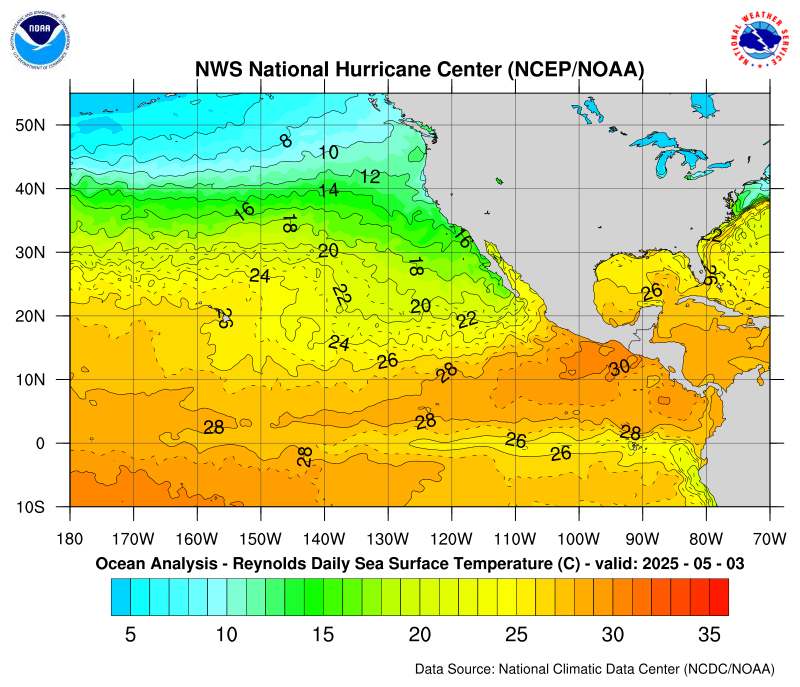
4-CPHC Sea Surface Temperature (>26-27 degrees C)
4-NHC Sea Surface Temperature
5-Eastern Pacific Wind Shear
6-Tropical Tidbits Computer Models
7-Tropical Cyclone Imagery - Storm Floaters
Climate Prediction Center - Global Tropical Hazards and Benefits Outlook
Japan Meteorological Agency
Hurricane Watch Net
Molokai near-realtime NEXRAD radar images
North Hawaii near-realtime NEXRAD radar images
South Hawaii near-realtime NEXRAD radar images
Hawaiian near-realtime NEXRAD radar images
NOAA NWS Weather Radar
Honolulu Weather Forecast Office Weather Forecasts
Current Hazards from the Honolulu Weather Forecast Office
Local Storm Reports from the Honolulu Weather Forecast Office
Hawaii SKYWARN Weather Spotter Information
Hawaii Hydrological data from the USGS
Marine warnings
Ultraviolet (UV) Index
Daniel K Inouye (Honolulu) International Airport weather information
Daniel K Inouye (Honolulu) International Airport aviation weather information
University of Hawaii - Department of Meteorology
Hawaiian Weather
Compilation of Honolulu Weather
N. Pacific Surface with GOES-18 IR Composite (UH Meteorology)
Visual description of wind barbs
High Quality Near Real-time Satellite Photos
Hawaii Surface Analysis
Marine Radiofax Charts
Surface Wind Visualization
Jet Stream Visualization at 250 mb
Jet Stream Analyses and Forecasts at 300 mb
Jet Stream Forecast for North Pacific
Teaching and Training Resources for the Geoscience Community
SpaceWeather.com - Sun, Solar Wind, Potentially Hazardous Asteroids
Space Weather Prediction Center
Solar Dashboard
Solar Radio Dashboard
ACE Satellite Real-time Solar Wind Data
Solar Prediction Center Products and Data
SWPC Data Services
SpaceWeather.com - Potentially Hazardous Asteroids
Here's What Would Happen if a Huge Asteroid Hit Your City
Here's What Would Happen If a Giant Asteroid Struck the Ocean
DXSummit HF real-time spots
SpaceWeather.com
Auroral Forecast Ovals
D-Region Ionospheric Absorption Predictions
WSPR Propagation Reporting System (for Israel paths, use callsign 4X/NH7L)
KH6HME VHF/UHF/SHF beacon spots
Hepburn Tropoducting Forecast Maps
VHF Propagation Maps Hawaii Skew-T charts
Grayline Terminator Calculator
The Heavens-Above.com website for Honolulu
Status of Amateur Radio aboard the International Space Station
Status of Radio Amateur Satellites
NASA Human Spaceflight
Keplerian Elements
Recent and Upcoming Satellite Reentries
Hawaii Interagency Vog Information Dashboard
Hawaii Vog Predictive Model
Hawaii Vog Predictive Model - Current Conditions
Hawaii Vog Predictive Model - Meteograms
USGS Hawaii Volcano Air Quality
Hawaii Department of Health SO2 Air Quality
Hawaii Department of Health Air Quality
Hawaii Air Quality Forecast
USGS Kilauea status
USGS Kilauea deformation and tilt meters(Time in HST)
USGS Kilauea status maps
USGS Mauna Loa status
USGS Mauna Loa monitoring data(Time in HST)
USGS Mauna Loa maps
Smithsonian Institute Weekly Worldwide Volcanic status
Tracking Matson Vessels
Matson Shipping Schedule
Pasha Hawaii Shipping Schedule
Hawaii Radiation Real-time Monitoring
Japan Radiation Real-time Monitoring
EPA Radiation Monitoring
EPA Fukushima Radiation Monitoring
Japan Reactor Status (PDF)
Japan Environmental Radioactivity Level By Prefecture
Japan Meteorological Agency
cdc.gov Influenza Info/a>
cdc.gov COVID-19 Info
Cyberattack Real-time Monitoring
A Global Display of Terrorism and Other Suspicious Events
Emergency Preparedness and Response - Preparedness for All Hazards - Center for Disease Control
Family Plan - Hawaii Emergency Management Agency
Emergency Preparedness - Hawaii Emergency Management
Hawaii Emergency Management Agency
Honolulu (Oahu) Department of Emergency Management
American Red Cross
Pacific Tsunami Museum
Nuclear Preparation Site
Electromagnetic Pulse Site #1
Electromagnetic Pulse Site #2
Electromagnetic Pulse Site #3
Amateur Radio Emergency Communications
Tsunami Status for Oahu and Hawaii
US Tsunami Warning CentersAustralia Tsunami Warning Center
India Tsunami Warning Center
Indonesia Tsunami Warning Center
Real-time DART Buoy data
NOAA Center for Tsunami Research - Tsunami Wave Height Forecast Map
NOAA US Tsunami Warning Centers
Tsunami educational video
Previous tsunami alerts for Hawaii
Hawaii Tsunami Inundation Maps (Pacific Disaster Center)
Hawaii Tsunami Inundation Maps (NOAA)
Tsunami Safety Information - Hawaii Emergency Management Agency
Surviving a Tsunami—Lessons from Chile, Hawaii, and Japan - USGS Circular 1187
International Tsunami Information Center
Emergency Management Alerts - For Hawaii
Hawaii Emergency Management AgencySigning up for County-Level notifications
Kauai Emergency Management Agency
Honolulu Department of Emergency Management Agency
Maui Emergency Management Agency
Hawaii County Civil Defense Agency
Hawaii Emergency Management Agency (EMA) on Twitter
FEMA Region 9 (Hawaii) on Twitter
FEMA on Twitter
Siren Status for the State of Hawaii
National Weather Service - Honolulu Forecast Office
National Weather Service - Honolulu Forecast Office - NOAA Weather Radio
NOAA Weather Radio All Hazards Alert You should get one of these radios to receive alerts.
EAS (Emergency Alert System) Event Codes
Hawaii County Coverage for NWS Weather Radio
Honolulu Board of Water Supply Main Breaks
Breaking News
Signing up for County-Level notificationsHonolulu Info Alerts
Nixle.com for Hilo
The Honolulu Star-Advertiser
KSSK AM and FM Radio
KHON TV
KITV TV
Hawaii News Now - KFVE, KGMB, KHNL
Hawaiian Electric Power Status
Hawaiian Electric Power Outage Web StatusHawaiian Electric Oahu Power Outage Web Status
Hawaiian Electric Oahu Power Outage Twitter Feed
Hawaiian Electric Maui Power Outage Twitter Feed
Hawaii Electric Light Company Big Island Power Outage Twitter Feed
Emergency Preparedness - For Hawaii
Hawaii Emergency Management AgencyOahu Department of Emergency Management (DEM) Information Brochures
HECO Handbook for Emergency Preparedness
Earthquakes
Automatically generated Hawaii earthquake alarmsEarthquake - Realtime worldwide map,1 Day, Magnitude greater than 2.5, depth of quake
Significant Earthquakes
USGS Earthquake web site
Earthquake - Global Overview
Earthquake - Near real-time seismographs
Lunar Distance and New/Full Moon Phase Calculator
NOAA Tide Predictions for Honolulu
Pacific Disaster Center
Air and Ground Traffic
Hawaii COVID Travel RulesFlights to-from HNL International
Flight arrival and baggage claim info for HNL International
Real Time Flight Information
Flight Delay Information - Alaska and Hawaii
Flight Delay Information - Air Traffic Control System Command Center
Upper Level Winds, North Pacific
HPD Traffic Incidents
Honolulu Traffic Cams
Hurricanes
1-Preparation plans for hurricanes2-NOAA Central Pacific Hurricane Center
2-NOAA Eastern Pacific Hurricane Center
2-NOAA National Hurricane Center
2-Eastern and Western Pacific Hurricanes
3-N. Pacific Surface with GOES-18 IR Composite (UH Meteorology)
4-CPHC Sea Surface Temperature (>26-27 degrees C)
4-NHC Sea Surface Temperature
5-Eastern Pacific Wind Shear
6-Tropical Tidbits Computer Models
7-Tropical Cyclone Imagery - Storm Floaters
Climate Prediction Center - Global Tropical Hazards and Benefits Outlook
Japan Meteorological Agency
Hurricane Watch Net
Hawaii NEXRAD Radar
South Kauai near-realtime NEXRAD radar imagesMolokai near-realtime NEXRAD radar images
North Hawaii near-realtime NEXRAD radar images
South Hawaii near-realtime NEXRAD radar images
Hawaiian near-realtime NEXRAD radar images
NOAA NWS Weather Radar
Earth Weather
Honolulu Weather Forecast OfficeHonolulu Weather Forecast Office Weather Forecasts
Current Hazards from the Honolulu Weather Forecast Office
Local Storm Reports from the Honolulu Weather Forecast Office
Hawaii SKYWARN Weather Spotter Information
Hawaii Hydrological data from the USGS
Marine warnings
Ultraviolet (UV) Index
Daniel K Inouye (Honolulu) International Airport weather information
Daniel K Inouye (Honolulu) International Airport aviation weather information
University of Hawaii - Department of Meteorology
Hawaiian Weather
Compilation of Honolulu Weather
N. Pacific Surface with GOES-18 IR Composite (UH Meteorology)
Visual description of wind barbs
High Quality Near Real-time Satellite Photos
Hawaii Surface Analysis
Marine Radiofax Charts
Surface Wind Visualization
Jet Stream Visualization at 250 mb
Jet Stream Analyses and Forecasts at 300 mb
Jet Stream Forecast for North Pacific
Teaching and Training Resources for the Geoscience Community
Space Weather and Potentially Hazardous Asteroids
Space Weather Prediction Center - Alerts, Watches and Warnings
SpaceWeather.com - Sun, Solar Wind, Potentially Hazardous Asteroids
Space Weather Prediction Center
Solar Dashboard
Solar Radio Dashboard
ACE Satellite Real-time Solar Wind Data
Solar Prediction Center Products and Data
SWPC Data Services
SpaceWeather.com - Potentially Hazardous Asteroids
Here's What Would Happen if a Huge Asteroid Hit Your City
Here's What Would Happen If a Giant Asteroid Struck the Ocean
Radio
Near Realtime Map of Maximum Usable FrequencyDXSummit HF real-time spots
SpaceWeather.com
Auroral Forecast Ovals
D-Region Ionospheric Absorption Predictions
WSPR Propagation Reporting System (for Israel paths, use callsign 4X/NH7L)
KH6HME VHF/UHF/SHF beacon spots
Hepburn Tropoducting Forecast Maps
VHF Propagation Maps Hawaii Skew-T charts
Grayline Terminator Calculator
The Heavens-Above.com website for Honolulu
Status of Amateur Radio aboard the International Space Station
Status of Radio Amateur Satellites
NASA Human Spaceflight
Keplerian Elements
Recent and Upcoming Satellite Reentries
Volcanic
NOAA Satellite and Information Service, NESDIS images of HawaiiHawaii Interagency Vog Information Dashboard
Hawaii Vog Predictive Model
Hawaii Vog Predictive Model - Current Conditions
Hawaii Vog Predictive Model - Meteograms
USGS Hawaii Volcano Air Quality
Hawaii Department of Health SO2 Air Quality
Hawaii Department of Health Air Quality
Hawaii Air Quality Forecast
USGS Kilauea status
USGS Kilauea deformation and tilt meters(Time in HST)
USGS Kilauea status maps
USGS Mauna Loa status
USGS Mauna Loa monitoring data(Time in HST)
USGS Mauna Loa maps
Smithsonian Institute Weekly Worldwide Volcanic status
Maritime
Real Time Ship InformationTracking Matson Vessels
Matson Shipping Schedule
Pasha Hawaii Shipping Schedule
Radiological
US Radiation Real-time MonitoringHawaii Radiation Real-time Monitoring
Japan Radiation Real-time Monitoring
EPA Radiation Monitoring
EPA Fukushima Radiation Monitoring
Japan Reactor Status (PDF)
Japan Environmental Radioactivity Level By Prefecture
Japan Meteorological Agency
Health
Developments on Avian Influenzacdc.gov Influenza Info/a>
cdc.gov COVID-19 Info
Technology
Internet Website OutageCyberattack Real-time Monitoring
A Global Display of Terrorism and Other Suspicious Events
Past Incidents on Oahu
Web site listing past incidents of interest to OahuEmergency Preparedness - More
US Federal GovernmentEmergency Preparedness and Response - Preparedness for All Hazards - Center for Disease Control
Family Plan - Hawaii Emergency Management Agency
Emergency Preparedness - Hawaii Emergency Management
Hawaii Emergency Management Agency
Honolulu (Oahu) Department of Emergency Management
American Red Cross
Pacific Tsunami Museum
Nuclear Preparation Site
Electromagnetic Pulse Site #1
Electromagnetic Pulse Site #2
Electromagnetic Pulse Site #3
Amateur Radio Emergency Communications
Copyright © 1997-2023 Ron Hashiro
April 12, 2006 Updated: November 26, 2023 DISCLAIMER: Ron Hashiro Web Site is not responsible for the content at
any of the external sites that we link to and therefore
is not necessarily endorsed by us.