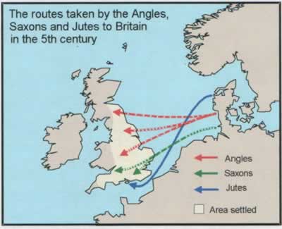
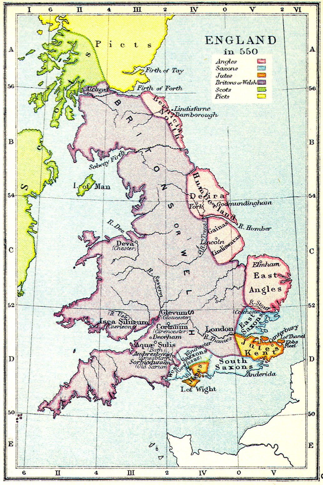
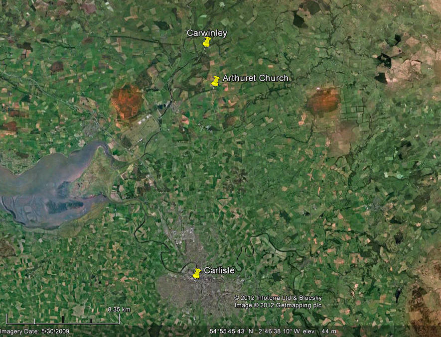
575 AD
Battle of Gwen Ystrad
(Or White Strath). King Theodric and
Urien Rheged
battled (on the banks of the upper Tees???)
Urien was victorius. Urien's
champions at this battle are described as the "men of
Catraeth".[Catterick? Not proven]. I have found this
excellent website
Caelin's
Chronicle with an interactive map that suggests Catraeth was an area
North of Salway between the rivers Tweed and Teviot in Southern modern day
Scotland.
See
Taliesin reference
for clues to battle location
'A mound and
slanting ground obstructing'
'Hand on the cross
they wail on the gravel bank of Garanwynyon'
'When he furiously
attacked his foes at the white stone of Galystem'
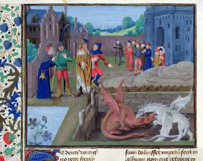
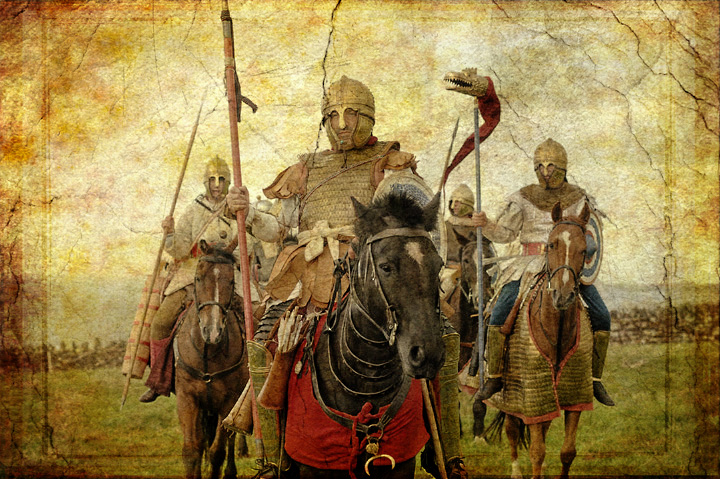
Y Gododdin
written by the Welsh poet, Aneirin, c. 6th century. Here, the poem
only mentioned his name, once, referring to a warrior in the poem as
being brave "but he was no Arthur".
| |
He charged before
three hundred of the finest,
He cut down both centre and wing,
He excelled in the forefront of the noblest host,
He gave gifts of horses from the herd in winter.
He fed black ravens
on the rampart of a fortress
Though he was no Arthur. |
| |
Y Gododdin
by Aneirin (c. 6th century)
|
|
[This appears to have
been a battle between the armies of Gododdin and Rheged, led by Urien. Note
the reference to Black ravens and not being as good in his opinion as Arthur.
There is a
suggestion that Garanwynyon is the same place as Arthur's 8th Battle at
Guinnion Fort]
579
Battle of Argoed Llwyfein. Theodric and
Urien battle again (location unknown) Urien and Owain won, Theodric
slain.
Urien is depicted as being a Cavalry
leader, the earlier reference to numerous horse skeletons and bones outside
Yeavering Bell may be related to this battle?
[River Lyvennet (means abounding in
Elm trees) in the Lyvennet Valley, Eden
Valley, Cumbria. Crosby Ravensworth
is considered to be the site of Urien's summer palace. (NY619149) (Urien's motif is
the Black Raven)]
It was at this battle that King Theodoric Flamddwyn (the
Firebrand) of Bernicia was killed by Urien's son Owain.
|
The Battle of
Argoed Llwyfain
Attributed to Taliesin
|
On Saturday morning there was a
great battle
From sunrise to sunset
Fflamddwyn advanced with four companies;
While the army of Goddau and
Rheged was
gathering
Summoned from Argoed [NE Wales] and as far as Arfynydd
[Anglesey]
They shall not delay even for a day
Fflamddwyn shouted with great boasting
'Will they give me hostages? Are they ready?'
Owein answered,
the ravager of the east
'They will not give them. They were not, they are not ready;
And a brave whelp of
Coel's breed would be sore afflicted
Before he gave a single hostage.'
Urien, lord of
Yr Echwydd
[Unidentified but
could sound in Welsh like Rheged], shouted
'If there be talk of peace,
Let us raise a rampart on the mountain.
Let us raise our faces over the top.
Let us raise our spears over our heads men,
And charge Fflamddwyn in the midst of his host
And slay him and his companions.'
By the Elm Wood there were many corpses
Ravens were
blooded by the warriors
And men rushed forward with their chief.
For a year I will sing a song to their victory! |
[
Of Crosby Ravensworth ANTIQUITIES.
Within this parish we have:—Stone Circles, (1) called the "Druid Circle"
half a mile W. of S. from Oddendale; (2) another half a mile N.N.E. of
Hardendale; (3) a circle and tumulus at Iron Hill, three quarters of a mile
S. of W. from Harberwain.
Tumuli:—"Penhurrock" on Coal Pit Hill; (2) "Seal howe," half a mile S. of
Oddendale; (3) a long barrow, quarter of a mile west of Oddendale; (4)
another north of Iron Hill circle; (5) another a quarter of a mile south of
Harberwain; (6) one on Dale Moor; (7) another half a mile N.N.W. of Meaburn
Hall; (8) one on Bank Moor, one and a half mile south-east of the church;
(9) two east of Gilts; (10) one on Crosby Gill three-quarters of a mile
south of Crosby Lodge; (11) another a quarter of a mile W.N.W. of the last
at an altitude of 1156 feet; (12) another one mile E. of S. from Gilts.
British Settlements:—(1) "Ewe Close"; (2) "Ewe Locks" onethird of a mile
south of Ewe Close; (3) "Burwans" a quarter of a mile north-east of Crosby
Lodge; (4) "Howarcles" a quarter of a mile S.S.E. of Woodfoot; (5) another
on Wickerslack Moor; (6) "Burmont" between Reagill and Sleagill.
Collingwood, Ancient Monuments.
Roman Road:—"Wicker Street" came up from the fort at Low Borrow Bridge, but
instead of crossing the Lune eastward to the village of Tebay as the modern
Turnpike does, it continued straight northward following more or less in the
line of the railway as far as Sproat gill, it then passed Howe Nook and made
a straight line for three miles over Crosby Ravensworth Fell to Ewe Close
where the line is well marked. From the British Settlement of Ewe Close the
road led on to Harberwain, Wickerslack, Reagill, Sleagill and Sandwath
Bridge to Brougham.
Crosby Ravensworth Dyke:—There are the remains of a dyke, some
three-quarters of a mile long, running parallel with the Lyvennet beck north
and south, and lying midway between the British Settlements of Ewe Locks on
the west and Burwans on the east. From: 'Parishes (West Ward): St Laurence,
Crosby Ravensworth', The Later Records relating to North Westmorland: or the
Barony of Appleby (1932), pp. 302-324. URL: http://www.british-history.ac.uk/report.aspx?compid=43522
Date accessed: 17 July 2012.]
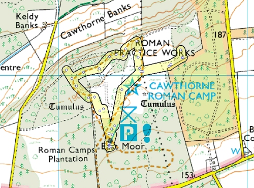
580
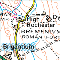
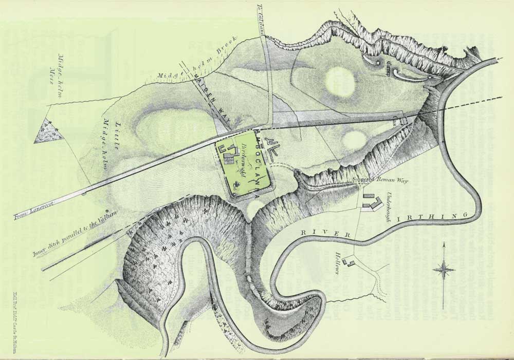
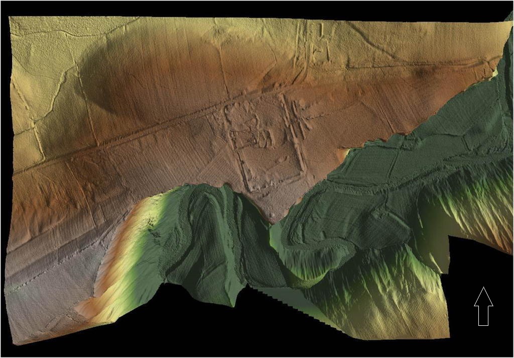
Battle of Caer
Greu (Roman Fort at Cawthorn), where Urien's cousins Peredur (Steel
Arms) of Eborac (of York?) and
his brother Gwrgi were killed by
Angle King AElle
of Deira (aka Eda Great Knee? - Welsh Triads reference) who had sallied out of Bamburgh with his Army. [Apparently
as a result of Peredur's death and defeat York fell, Urien had to rush
troops to Catterick]

584 AD
German Angles have spread
West slowly, but still halted by King Urien Rheged in Cumbria
588
AD
German Angle King AElle of Deira dies
and is succeeded by Hussa
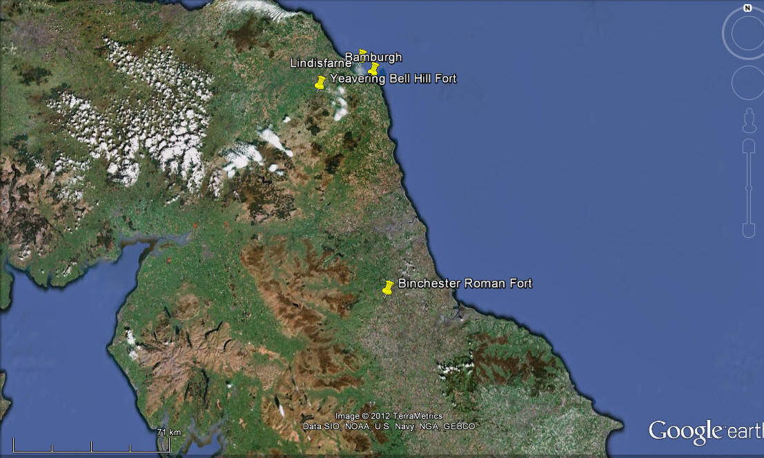
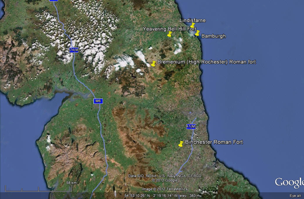
590 AD Bamburgh (Din Guyardi) captured by King
Urien Rheged and his Brythonic allies from the German Angle King Hussa, who is then
besieged at Lindisfarne and nearly driven out.
Urien Rheged
besieged the German Angles on Lindisfarne Island for 3 days and 3 nights.
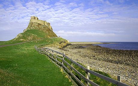
However
Urien was later assassinated by a man called Llofan Llaf Difo
(Severing-Hand) at nearby Aber LLeu (modern nearby Ross Low on
the nearest land approach to Lindisfarne island)
aka 'Lleu's estuary', at the instigation of
king
Morcant Bulc a
British ally fearing Urien's power over all the Britons should he defeat the Angles, which he was close
to achieving. The alliance of the four Brythonic kingdoms collapsed.
His [Urien's]chest had been pierced by a staff (or spear) ref: Red Book of Hergist].
Urien was beheaded and his head was
carried home by his son Owain map Urien. [Presumably because the
distance home was many days horse ride away and the sight of his body would
have unnerved his followers on the route home] His corpse was buried beneath a
cairn, under blue stone covers. [I have visited Ross Low and the
natural stone there is blue]
From 570-590
Urien Rheged had ruled and been a strong King over Rheged, keeping the
Angles confined and nearly driving them out.
*Ac yny vallwyf hen ym
dygyn aghen. Ny bydif ymdirwen na molwyf Vryen.
"Until I am old and ailing, in the dire necessity of death, I shall not be
in my element if I do not praise Urien."
~ Llyfr Taliesin
Uriens twin sister
Efrddyl is in mourning
Owain map Urien (son of Urien Rheged)
succeeds as king of North Rheged. [He becomes in later legends, written
in the 1800's, a Knight of King Arthur's Round Table and is mentioned at
being present in King Arthur's court, however this is not historically
possible as historical Arthur died in 537 AD. However he would have been
alive at the time of Arturis and his father Urien had married Morgan sister of
Arturis]
Civil War breaks out
between the 13 kings of Northern Britain.
591 AD King Dunaut Bwr (The battle Horseman) aka
King Dunawd of the
'Northern Pennines' and previously an ally of king Urien Rheged
mounts an invasion of North Rheged, but is repulsed and defeated by its King Owain, and
his brother, Prince Pasgen.
Prince Elfin (of North Rheged?)
defeats a simultaneous attack by King Gwallawc Marchawc Trin (aka Gwallarg) of Elmet.
592 AD German Angles under Hussa invade the
mainland again from Lindisfarne and are only stopped by Owain of Rheged who
slays Hussa in battle.
Ethelfrith (Ethelfrid in Bede's history)
succeeds as Angle King of Lindisfarne from his father King Hussa. Urien's brother
Arawn dies and King
Rhydderch Hael
absorbs Salway into Strathclyde,
595 The aging King Dunaut Bwr (The Stout) of the Northern
Pennines dies fighting off a Bernician invasion. His Pennine kingdom 'Dunoting' is overrun by
the German Angles.
597
British
King
Morcant Bulc,
king of Bryneich, dispossessed king of
Bernicia, attacks Rheged and kills Owain, fatally weakening the Rheged kingdom.
Prince Pasgen his brother flees to the Gower peninsular in Wales. Owain was buried in a secluded part of the world, under the sod of Llan-Morvael
(Llan Morvad),
in LLan-Heledd which has not
been positively identified.
[Some believe this may be in what is now St.Andrew's church yard in
Penrith, but this is unproven and may be confused with the Giant's grave of
the later Owen Caesarius?]
"Bet Owein ab Urien im pedryael bid,
dan gverid Llan Morvael."
(The grave of
Owein ab Urien is
square-fashioned,
'neath the earth of Llanforfael.)
"His grave is
girted
with four stones. Llan-Forfael (church of the Great prince) in LLan-Heledd"
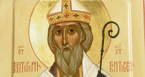
St.Mungo (St. Kentigern)
is a possible son of Owain map Urien. However, he may have been born in 528
AD to Thenew the
daughter of Loth, King of the Goddodin which makes him too old to be the son
of Owain map Urien.
597 AD Elfin map Owain (son of Owain) becomes king
of North Rheged. The
Book of Taliesin
was written by a poet called 'Taliesin of Rheged'
c.534-599 in the 6th Century, it contains several references to
Arthur and Urien. Prince Pasgen flees to the Gower peninsular.
598 AD
Rhun youngest
son of Owain kills King Morcant Bulc of Breneich at the
Battle of Catraith.
[This location is
believed by some to be Catterick, in North Yorkshire, but this theory remains
unproven. A battle between German Angle King Æthelfrith of Bernicia
who defeated Mynyddog of Gododdin.]
[Also at this battle was
Cynon ap Clydno, a hero here, whose lover was
Owain's twin sister Morvudd (Morfydd), daughter of Urien Rheged.] Apparently
363 mounted horsemen (cavalry) on the British side against several thousand German
Angle infantry. Despite killing many of the Angles they were slaughtered by
overwhelming numbers. Only 3 or 4 British warriors survived this battle
Rhun, Cynon,
and Aeron's two war hounds.
This was the final
decisive battle of the 6th Century and a catastrophe for the fragile
alliance of British kings.
c.603 AD Battle of Degsastan (Degsa Stone) where
'Aedan king of the Scots' [alternative possible father of Arturius]
brought a large army against German Angle King Ethelfrith (Ethelfrid) and suffered a major defeat. [Location
of this battle is still being debated see this fascinating forum] [Dawston?]
604 AD German
Angle King Ethelfrith (Ethelfrid) invades Deira and kills its King and takes
the kingdom. Prince (later King) Edwin of Deira flees.
c.613/620
AD
King Llywarch
Hen (the Old) flees from South Rheged to Powys in Wales.
South Rheged has fallen to the German
Angles.
614 AD St.Mungo (St. Kentigern) dies in Glasgow.
616 AD Battle of the River Idle. King Edwin of
Deira, with the help of
King Raedwald
of East Anglia, conquers Northumbria at the Battle of the River Idle.
King Ethelfrith of Bernicia & Deira is killed in the fighting and his
children are forced to flee into exile,
Prince Oswiu of Bernicia flees to
Ireland.
North Rheged is
overrun and
King Elfin of Rheged is
killed by
King
Edwin of Deria
and Bernicia (later to be called collectively Northumbria) North Rheged comes under the rule/occupation
of Bernicia with Prince Rhun of Rheged either captured or subjugated.
617 AD Elmet is captured by
King
Edwin of Deria
and Bernicia
c.617 or 623 AD
King
Edwin of Deria
and Bernicia is baptised with his Army as Christians by Prince Rhun of North
Rheged.
625 AD British King Cadwallon of Gwynedd comes to the
throne.
626 AD attempted assassination of Geman Angle
King
Edwin of Deria
and Bernicia by
German Saxon Eamer from West Sussex.
The Isle of Man
(Ynys Manau) is invaded and overrun by
King
Edwin of Deria
and Bernicia, followed by Anglesey. Cadwollon flees to Brittany.
630 AD King Cadwollon of Gwynedd returns from
Brittany and joins forces with Pendle of Mercia and at the Battle of the
Long Mountain they defeat Derian forces and chase them all the way back to
Northumbria.
Prince Rhun of Rheged
dies and his son, Royth, rules a weakened state dominated by Edwin of
Northumbria.
632 AD German angle King Edwin's country palace at
Ad Gefrin (Yeavering
Bell) on the river Gle(i)n in Northumbria burnt down by Penda of Mercia and
Cadwallon of Wales.
633 AD German Angle
King
Edwin of Deria
and Bernicia
and his son Osfrith die at the
battle of Hatfield Chase (near Doncaster), killed by British King Cadwallon of Gwynedd, and is succeeded by
German Angle
Oswald of
Northumbria, son of Angle Aethelfrith of Bernicia.
Prince Oswiu of
Bernicia returns from exile in Ireland having previously married an
Irish princess called Fin.
The
Isle of Man is no longer ruled by Bernicia.
634 AD
British king Llywarch Hen (the Old) dies, aged
around 70, the last
king of South Rheged who had fled to Powys in Wales 21 years earlier.
King Cadwallon of
Gwynedd is defeated and dies in the
battle of
Heavenfield, fought between a Northumbrian German Angle Army under King Oswald and a British (Welsh) Army under King Cadwallon, 4 miles North of Hexham on Hadrian's Wall.
|
Chronology of Kings of Rheged/Cumbria |
|
Name |
Born |
Ruled |
Kingdom |
Died |
Children/Comments |
| |
|
|
|
|
|
| Coel Hen (Caelius Votepacus) |
c.350 |
-420 |
Northern
Britain, Duke of Britain |
420 |
Upon his
death 13 petty kingdoms established, given to his descendants.
One son Cenue ap Coel Hen another called Gorbanian, does that
mean there were 11 more? |
|
Sons of Coel
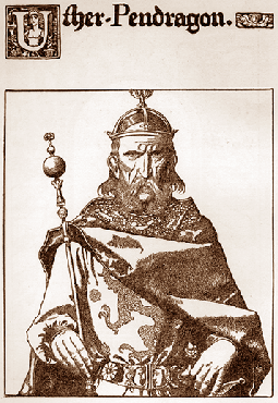
Hen, but who? What about Ambrosius or Abrosius's brother Uther
Pendragon as a possible fit? |
b.420 |
420- |
? |
|
|
|
Ambrosius |
c.414 |
c.458-479 |
? |
c.479 |
"The Great
King amongst the Kings of Britain" |
|
Uther
Pendragon |
c.420 |
479-495 |
|
495 |
|
| |
|
|
|
|
|
|
Cenue ap Coel (Hen) |
c.375 |
-470 |
|
c.470 |
|
|
Gwrast Ledlwm (The Ragged) |
422 |
c.470-c.475 |
Greater Rheged |
c.475 |
Meirchion Gul (The Lean)oldest son/Masgwid (Mascuid) Gloff
(younger son granted Elmet) |
|
Meirchion Gul(The Lean) |
c.455 |
475-535 |
Greater Rheged |
535 |
Cynfarch Oer/Elydyr Llandewyn
(the Stout & Handsome)/Gorlois
of Tintagel |
| Cynfarch Oer
(The Dismal) |
c.520 |
535-570 |
North
Rheged |
570 |
Urien Rheged |
|
Urien Rheged |
c.540 |
570-590 |
North
Rheged |
590 |
Eldest son
Owain Rheged. Daughter Morfydd
(possible twin of Owain). Son Pasgen. Blue denotes decendant of Urien Rheged |
|
Owain Rheged |
c.560 |
590-597 |
North
Rheged |
597 |
St.Kentigern (d.614)
Oldest son Elfin/ Youngest son Rhun |
|
Elfin map Owain |
c.576-c.580 |
597-616 |
North Rheged |
616 |
Last King of North Rheged before
German Angle conquest of area |
|
Rhun map
Owain |
before 597 |
616?-630 |
Occupied
North Rheged? |
|
Rhun
baptises Edwin and 12,000 followers c.617. Son Royth. |
|
Royth map
Rhun |
|
630-634? |
Rheged
dominated by Northumbria |
|
Daughter
Princess Reinmelt born in Caer Lugas (Carlisle) |
|
Princess
Reinmelt |
c.600 |
|
|
641 |
Marries
Prince Oswiu of Bernicia in c.634 (his 2nd wife) uniting British
Rheged with German Angle Northumbria.
Eahlfrith (Alhfrith)her son and Eahlflaed (Alchflaeda) her
daughter but dies in childbirth (daughter later married Peada brother of Cyneburh, children of
Pendle) |
|
Eahlfrith (Alhfrith) |
c.635 |
c.655-664 |
Sub King of
Deira (Part of Northumbria) |
|
married
King Pendle of Mercia's daughter Cyneburh c.650. Disappears from
records from 664 and Synod of Whitby until 685. Children: Osred
(King Osred of Northumbria)
St. Cuneburga of Gloucester,
St. Edburga of Gloucester, St. Weeda of
Gloucester, St. Eva of Gloucester and the
extraordinary baby St. Rumwold born 662 died 662. |
|
Ecgfrith son of Oswiu |
|
670-685 |
Northumbria |
|
Died in battle |
|
Aldfrith son of Oswiu (same as Alhfrith?) |
|
685-705 |
Northumbria |
|
Eldest son
Osred, yoinger son Osric |
|
Osred |
c.697 |
705-716 |
Northumbria |
|
|
| Coenred |
|
716-718 |
Northumbria |
|
Descendant
of Ida the flamebearer |
|
Osric |
c.700 |
718-729 |
Northumbria |
|
End of Urien
Rheged's line in the North. Possible alternative line of descent
continued through his son Pasgen in Wales. |
| Ceolwulf |
|
729-737 |
Northumbria |
|
Brother of
Coenred and adopted as heir by Osric. |
| |
|
|
|
|
|
| |
|
|
|
|
|
|
Elidyr Llydanwyn (The Stout & Handsome) |
b.535 |
535-560 |
South
Rheged |
560 |
Llywarch
Hen (The Old) |
|
Llywarch Hen (The Old) |
b.560 |
560-613 |
South
Rheged |
634 |
South
Rheged overrun in 613 flees to Powys and dies there in 634.
He would have been at
least 74 from ruling in 560 to death in 634! if he ruled from
lets say age of 16 then he would have been at least 90! |
| |
|
|
|
|
|
|
Owen (Owain)
Caesarius |
b.902 |
918-937 |
Cumbria |
937 |
Son of King
Aed of the Picts |
|
King Dunmail
(Dyfnwal
III) |
b.920 |
937-945 |
Cumbria |
945 or 975 |
Son of Owen
Caesarius |
|
Máel Coluim (Malcolm I), king of
Strathclyde |
b.930 |
945-954 |
Strathclyde
& Cumbria |
954 |
Son of
Dunmail |
|
King Dunmail
(Dyfnwal
III)????? |
b.920 |
954-973 |
|
975 in Rome |
5 sons -
Malcolm I, two blinded, Amdarch and Eogen |
| Malcolm II
(or Amdarch son of Dunmail?) |
b.955 |
973-997 |
Cumbria |
997 |
|
|
King Eogan (Owen II/Eoghain II) |
b.975 |
997-1018 |
Cumbria |
1018 killed
in the battle of Carham |
Owen/Owain the Bald a 5th son of king Dunmail |
| |
|
|
|
|
|
| |
|
|
|
|
|
| |
|
|
|
|
|
| |
|
|
|
|
|
| |
|
|
|
|
|
| |
|
|
|
|
|
| |
|
|
|
|
|
| |
|
|
|
|
|
| |
|
Legend of
Arthur characters with Rheged/Cumbria/Northern Britain
connections |
|
Name |
Born |
Ruled |
Kingdom/Ruler |
Died |
Children/Comments |
|
Ambrosius |
c.414 |
c.458-479 |
|
479 |
Artorius/Brother Uther Pendragon? |
| Uther Pendragon |
c.420 |
479-495 |
|
495 |
Arthur Pendragon |
| Arthur Pendragon
(King/Warrior Arthur of
Legend) |
c.480 |
495-537 |
|
537 |
Arthus was
born and lived at Tintagel until he was 15. Amr step-son of
Arthur killed by him. Llachau mentioned in Welsh Triads. |
| Gorlois of
Tintagel |
b.440 |
c.458-479 |
Tintagel,
Duke of Cornwall |
479 |
Gorlois is the 3rd son
of a King of Greater Rheged. In c.458 Gorlois, Uther and
Ambrosius defeat and kill Vortigern |
| Arturus |
|
|
|
|
Son of
Aiden |
| |
|
|
|
|
|
| |
|
|
|
|
|
| |
|
|
|
|
|

c.634/c.638 Rheged was
incorporated peacefully into Bernicia, through the marriage of British Rhegedian
Princess Riemmeltt
(Rienmelth
daughter of Royth, son of Rhun)
born c.600 AD, heiress of Rheged,
to
German
Angle
Prince (later King) Oswiu of
Northumbria after his first wife had died.
British Queen Riemmeltt (of Rheged) bore two children Eahlfrith (Alhfrith) her son
c. 635 and Eahlflaed (Alchflaeda)
her daughter.
642 Oswiu (Oswy) becomes German Angle king of Bernicia following
the death of his brother King
Oswald of Northumbria at the hand of the powerful
rival German
king Pendle of the Anglia
Mercians (Anglo-Saxons) and Oswiu strengthens his own position by
now marrying Edwin's exiled daughter Eanflaed (his 3rd wife.
Deira
is ruled separately by King Oswin of Deira as Oswiu is deemed unacceptable
to them being only a half-brother of their previous King.
c.650 German/British Prince Eahlfrith (Alhfrith), son of
British Queen Riemmeltt of Northumbria, marries German Angle Princess Cyneburh (Cuneberga) of Mercia
(daughter of King Pendle) in an attempt to forge an alliance between these
warring German factions through marriage. Prince Eahlfrith would have been around
15 years old.
651 King Oswin of Deira murdered, by King Oswiu
Of Bernicia after Oswin refuses to take part in armed conflict, and is
succeeded by king Aethelwald of Deira
c.652 German/British Princess
Eahlflaed (Alchflaeda), daughter
of British Queen Riemmeltt of Northumbria,
married German Prince Peada, brother of Cyneburh, son of King Pendle of Mercia.
Despite the marriage
of two sons and two daughters of both German Angle King Oswiu of Bernicia/Deira and
German King
Penda of Mercia to each
other, war was never far away.
655 King Pendle of Mercia attacked Bernicia with a
much larger army,
but was surprisingly defeated and killed at the
Battle of the
Winwaed River on 15th November. This battle is believed to have taken
place at Cock Beck, near Leeds and it left Oswiu as King of Bernicia, Deira (Now merged as
Northumberland) and defeated Mercia. Prince
Eahlfrith (Alhfrith) had fought at this battle where his father-in-law was
killed.
Prince Eahlfrith (Alhfrith)
appointed sub-King of Deira by his father King Oswiu, as apparently king
Aethelwald of Deira had withdrawn his forces to await the outcome of the
battle and was replaced!
656 King Peada of Middle Anglia
(Leicestershire) murdered at Easter through the treachery of his wife Queen
Eahlflaed (Alchflaeda)!
Northumbria now rule Mercia!
658 Mercia rebel and regain independence.
664 Synod of Whitby. Sub king Eahlfrith (Aldfrith)
religious opposition to his father King Oswiu, fails. Aldfrith possibly
leaves in exile to Hebridean island of Iona according to one account another
suggests he dies?
Plague/Pestilance
recorded in Northumbria, Southern Britain and Ireland.
665 The Second battle of Badon Hill. A Saxon
(Angle?)
victory against the Britons of Gwent. I can't find any reference to who
fought at this battle, which is unusual.
670 Angle King Oswiu (Oswy) of Northumberland dies,
succeeded by his son King Ecgfrith (Egfrid).
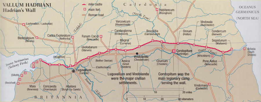
The Bewcastle cross
South side inscription reads "In the first year of the reign of Egfrid King
of this Kingdom" and the cross itself West side inscription reads "This
slender pillar Hwætred, Wæthgar, and Alwfwold set up in memory of Alefrid, a
king and son of Oswy. Pray for them, their sins, their souls". This tells us
that the cross was likely carved after 670/704 and that Alefrid was dead by this
time. I believe that Alefrid is the same person as
Alhfrith (Ealfrith)
of Deira?
679 Sub king Alfwine
of Deira (brother of King Ecgfrith (Egfrid) of Bernicia killed at the battle
of the Trent against Mercian forces.
685 Pict Army major victory at the battle of
Dun Nechtain defeats Angle
Northumbrian Army and kills King Ecgfrith of Northumberland, the successor
of King Oswiu. The Pictish frontier returned to the river Forth at
Edinburgh.
Northumberland now
ruled by Oswiu's other son Aldfrith (Alhfrith). Called back from
exile in Iona an illegitimate son of Oswiu.
In 685 Saint
Cuthbert (Bishop of Lindisfarne) visits Carlisle and is granted Carlisle and
all land and inhabitants in a 15 mile radius.
704 King Aldfrith (Ealdferth) of
Northumbria dies. Usurper Eadwulf seized the thrown for a few months and was
soon overthrown. Aldfrith's young son Osred (8 years old) was only a child and became King
with control of the government by Bishop Wilfred.
711 Picts suffer a major defeat by Northumbria
Angles in the area round the upper Forth.
716 King Osred of Northumbria is slain, possibly murdered by his successor Coenred, a descendant
of Ida the flamebearer.
718 Osric younger son of Aldfrith succeeds
Coenred
729 King Osric slain, the last Northern based
descendant of Urien Rheged (Weslh line may have continued through Urien's
son Pasgen). Ceolwulf succeeded.
c.731 Ad Gefrin (Yeavering Bell) palace
abandoned.
738 Eadbury succeeds to Northumbrian throne.
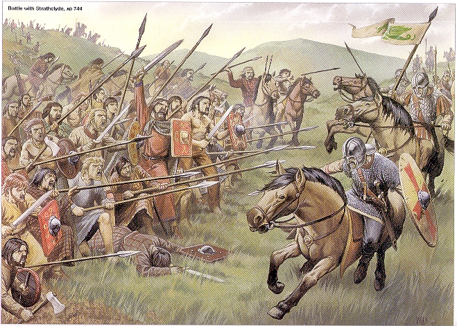
744 the Picts defeat the formidable Army of the
'Britons of Strathclyde'

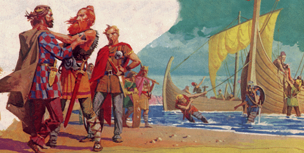
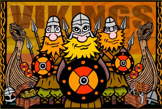
793
Lindisfarne raided by
Vikings. Lands
East of the Pennines, were seized by
Danish Viking
invaders that settled
there.
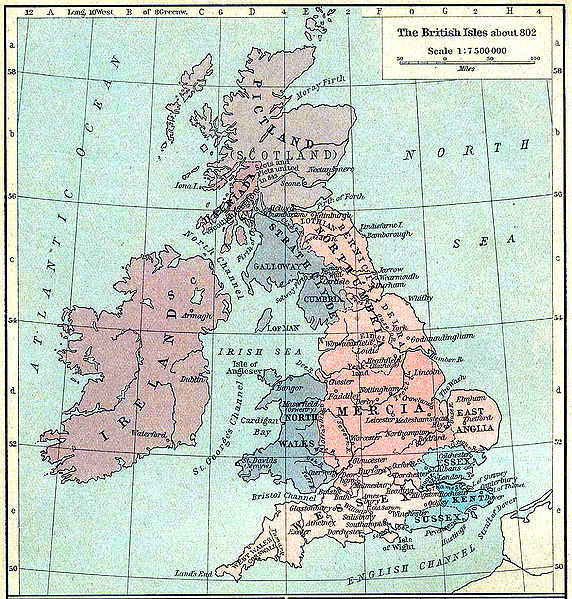
Map of British isles
circa 802. N.B. Cumbria
and Galloway together now form the the Norse controlled Kingdom of
Strathclyde. (Galloway and Cumbria)
c.815-c.832 Battle of Athelstaneford in Lothian when an Army of Picts
under King Angus invaded the Lothians (then under control of Northumbria)
and found itself surrounded by a larger Saxon Army under King Athelstan.
Fearing the outcome King Angus led prayers for deliverance and was rewarded
by seeing a cloud formation of a white Saltire against the blue sky, he
vowed that if he gained victory St.Andrew would become the patron saint. The Picts did win, Athelstan was killed, and the Saltire
eventually became
the flag of Scotland.
C.843
Kenneth
I first joint king of 'Scoti' Dalreada and the Picts to
form Scotland North of a line
between the Clyde and the Forth rivers.
845 The ship of Viking King Ragnar Lothbrok of Sjaelland & Uppsala
(Scandinavia) is supposedly blown off course and he lands in East Anglia. He
is entertained at the Royal Court but internal politics leads to him being
kidnapped and smuggled into Northumbria where he is executed in a pit of
vipers.
865 The 'Great Heathen Army' of Vikings, led by Princes Ivarr the
Boneless and Halfdan Wide-Embrace of Sjaelland & Uppsala (Scandinavia),
invades East Anglia (supposedly in revenge for the execution of their
father, King Ragnar Lothbrok). King Edmund of East Anglia buys peace with a
supply of horses.
866 Vikings capture York
867 Danish Vikings capture Angle King Aelle
of Northumbria and 'spread Eagle' him in revenge. Deira captured.
870
Most Anglo-Saxon kingdoms had fallen to the
Danish Vikings (not including Cumbria or Bernicia), with the exception of English Wessex
under
King Alfred
the Great.
873 Danish Viking campaign against Norwegian Vikings in Dublin
failed.
c.875 Parts of Bernicia captured by the Danish Vikings.
c.877 Carlisle attacked and destroyed by Danish Viking Halfdan, who
ransacked the area, having travelled over Stainmore Pass. [The damage was so
bad that it allegedly took 200 years to recover. Penrith may have become the Capital of Cumbria
during this time.]
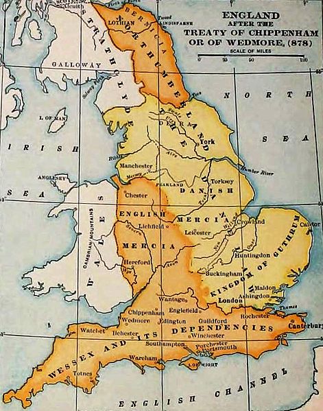
878 Establishment of
Danelaw [see map, yellow area under Danelaw] after Danish
Viking defeats by Alfred the Great of Wessex.
901
Edward the Elder,
king of Wessex and son of King Alfred the Great, "reduced to subjection the king of the Scots, the
Cumbrians, and the Strathclyde and Western Britons". [I
don't know who was king of the Cumbrians at this time, but possibly the
father of the later to be king Owen (Owain) Caesarius. King Aed of the
Picts?]
918 Native Irish expel 'Norwegian Vikings' from Dublin (King Olaf?), some of the
Norwegian Vikings crossed the Irish Sea and settled peacefully in Cumbria
having being welcomed as allies against the 'Danish Vikings'.
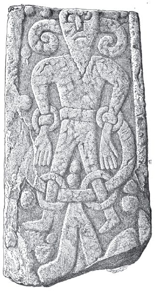
Loki stone from Kirby
Stephen, near Penrith, 10th Century Viking carving
918
Cumbrians voluntarily elect a 'brother of the Scottish King' to their own
throne. Identity unknown is it Owen Caesarius??? [Ref:
1869 book
Arthurian localities, page 26] Believed that Owen Caesarius is the
brother of Constantine, King of Strathclyde their father being Aed King of
the Picts. King
Owen (Owain)
Caesarius (Eogan I) succeeded as king of Cumbria.
924
Edward the Elder died, he had been the
Wessex king for 23 years.
c.925 Norwegian
Vikings continue to settle peacefully in Cumberland, having originally emigrated from Ireland.
[Estimated now that 20% of Cumbria population was Norwegian Viking]
[Many
residents of Penrith have been found recently
in 2000 to
still have
Norwegian Viking DNA, (from Norway), other tests on the
population elsewhere in
England settled by the Vikings,
such as the City of
York (Jorvik),
have found no Viking DNA in the population.]
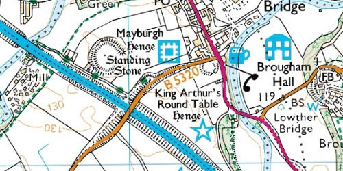
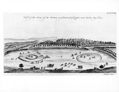
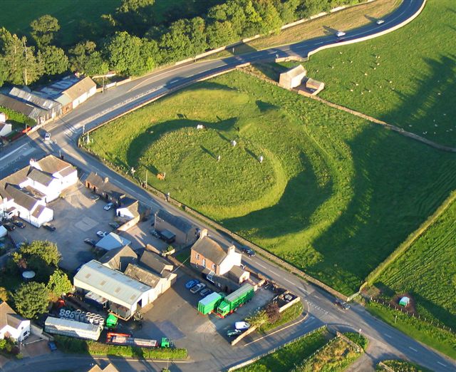
12 July 927,
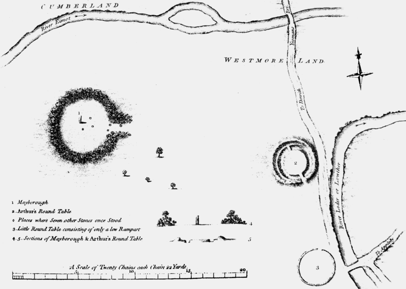
At Eamoton (modern Eamont Bridge, just outside
Penrith) was the scene of a gathering of the 5 kings from throughout
Britain as recorded in the
Anglo-Saxon Chronicle and the histories of
William of Malmesbury and
John of Worcester. Present were
AEthelstan (British King of Wessex),
Constantín mac Áeda (King of Scotland),
Owain of Strathclyde (King of Strathclyde & Cumbria),
Hywel Dda (King of Wales), and
Ealdred son of Eadulf (King of Northumbria).
This is generally seen as the date of the
foundation of the
Kingdom of England.

Inside
Dacre church is a fragment of an ancient pre-Viking cross
and a stone commemorating the 'Peace of Dacre' when the Saxon
King of England,
Athelstan, made peace with Constantine, King of Scots and
Owen Caesarius of Cumberland in 927,
at which Constantine and Owen converted to Christianity.
c.930 Penrith Viking Hoard buried,
artefacts from which were later found in 1785, 1830 and 2009. This is now
known as the
'Penrith
Hoard'.
937
Some history books suggest that
King Owen Caesarius
(Owen I)
of the Cumbrians was killed in
937 AD by the
English King AEthelstan of Wessex at the major
Battle of
Brunanburgh, where 5 Kings in total were supposed killed. There had been
an alliance of Scots, Celts, Danes & Vikings. (Burnley on the
river Brun?)
However
Scottish annals from Anglo-Saxon Chronicles differ with a quotation from
Symeon of Durham 'In the year 937 King
Ethelstan fought at Wendun and turned to flight King Olaf with six hundred
and fifteen ships, Constantine King of the Scots and the King of the
Cumbrians, with all their host.' i.e.
King Owen Caesarius
survived the battle and fled.
[I think it is a
possible scenario that King Owen Caesarius survived the battle initially and fled, but
had been wounded and died soon after the battle, allowing time for
travel and his body to be buried ultimately at Penrith. When the Giant's
Grave was excavated in the 16th Century a large skeleton was found (Owen was
apparently a man of gigantic stature according to scripts) buried with a
'Broad sword', which surely would have been taken as a war trophy had he
died on the battlefield? Also if killed at the battle site I don't think his
body would have made it back to Penrith, given that his army was routed.]
Owen (Owain) Caesarius,
King of Cumbria from 920 AD to
937 AD,
believed buried at Penrith in the
Giant's Grave.


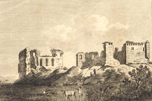
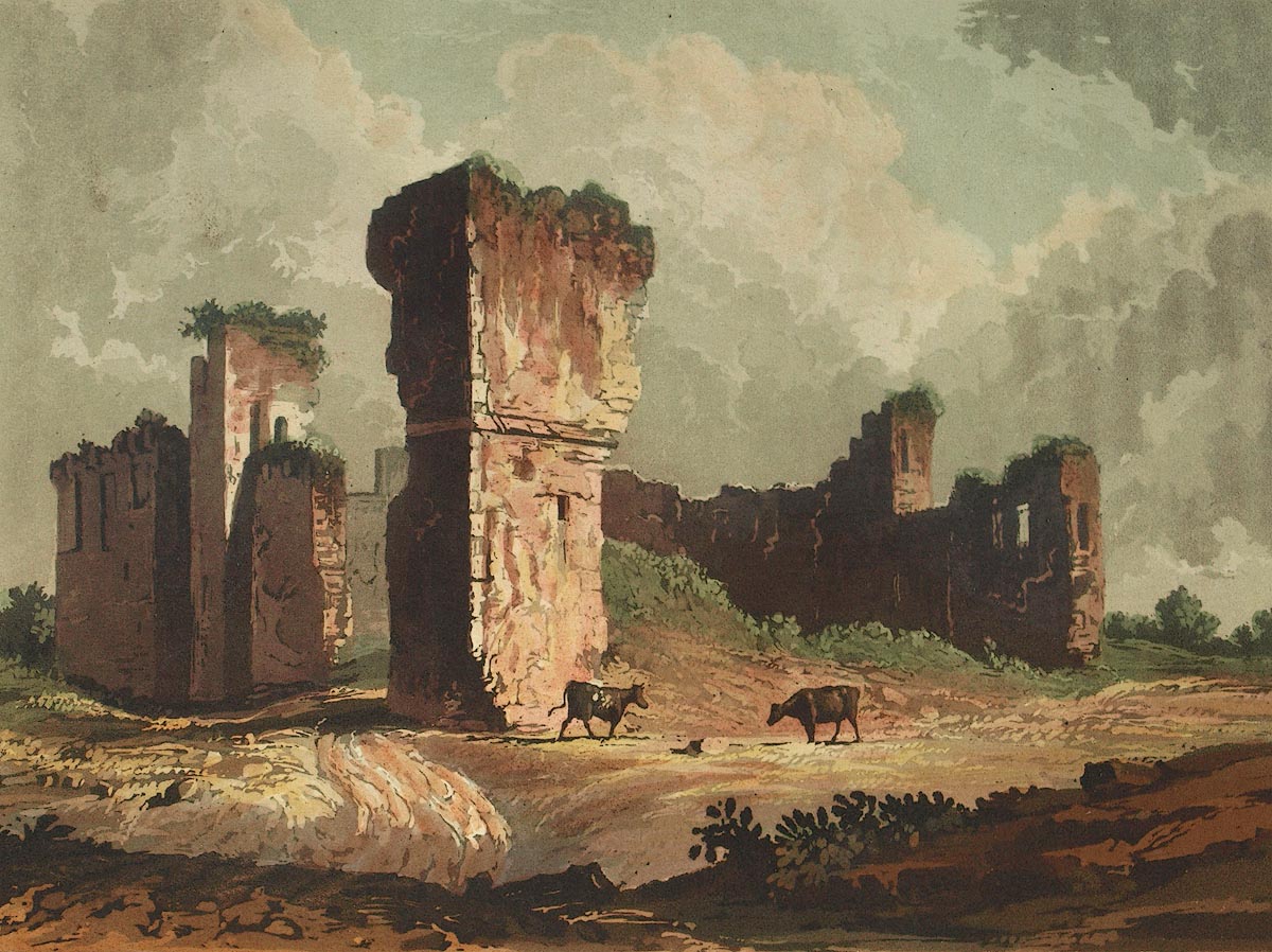
Castle Hewin (Owain's Castle) was located close to
High Hesket, 9 miles
North West of Penrith on the shore of Tarn Wadling. [A description of
which reads 'the remains of a very strong building are 233ft by 147ft beside
a small one at one corner 49ft sq. The foundations still appear faced with
large stones of ashlar work, in some places 8ft in thickness'.]
[Another
description reads "Near to it
is Tarn Wadling, a lake of 100 acres, which breeds some of the finest carp
in the kingdom, and borders upon a declivity that rises 600 feet above the
Eden. There were some years ago, on the crown of the lofty eminence on the
north east side of the lake, the remains of a very strong and ancient
building, 233 feet by 147, called Castle Hewin, but no traces of it
are now left. Tradition says it was one of the strongholds of Ewaine, king
of Cumberland."] From the book 'Beauties of England & Wales or deliniations 1802'
[Older name Ternewathelan c.1314]

[Castle, King writes tower, of probable medieval origin, recorded as
ruined by Leland in 1553. Also recorded by Hutchinson in 1794. The
site was ploughed out and all that remains is a depression near the
summit. Jackson thinks probably refers to a vanished Iron Age fort.
However, late C18 record of site reads 'the remains of a very strong
building are 233ft by 147ft beside a small one at one corner 49ft
sq. The foundations still appear faced with large stones of ashlar
work, in some places 8ft in thickness' apparently had circular
curtain wall. Excavated in 1978-9, by Tom Clare, and found to be
Romano-British. Chandler transcribes Leland as "Six miles from
Carlisle in Inglewood Forest may be seen the ruins of a castle
called Castel Luen. I must remember to find out from the (Antonine)
Itinerary the positions of the old towns." NY48544627]
937
King Dunmail
(Dyfnwal
III)
succeeded, upon the death of his father Owen/Owain Caesarius (Aed's son, so
brother of Constantine), as the King of the
Cumbrians.
940 A battle victory recorded for Edmund over Constantine mac Aeda,
the 'Strathclyde' Britons and a Dublin Viking called Olaf Cuaran.
c.941
King
Dunmail of Cumbria visited by
Cathroe of Metz
943 Constantine abdicated his throne as King of Alba, handing power
to the son of his nephew -
Malcolm I, son of King Dunmail (Donald)????//
945 'almost' the last British King of the Cumbrians
King Dunmail
(Domnall m. Eogain,
rí Bretan)
lost the
battle, at what is called now Dunmail Raise, near
Grasmere to the Anglo Saxon
King
Edmund ‘The Magnificent’ of Northumbria.
Two sons of King Dunmail were
deliberately blinded by Edmund and Cumbria was granted to
another son
Máel Coluim (Malcolm I), king of
Strathclyde
(Dunmail was a relative of
Constantín mac Áeda who had fought on the side of Dunmail's father Owen
Caesarius)
in return for his future alliance.
Two variations of what happened to King Dunmail at this battle exist. One
local tale says King Dunmail was killed and his crown thrown into a nearby tarn
above the battlefield and that a mound of cobbles at the top of Dunmail
Raise marks his burial site. Another more historically accurate version has it that King Dunmail
survived and eventually went on a pilgrimage to Rome, dying there and that
the mound of stones at Dunmail Raise were placed there by his warriors prior
to the battle in the belief that if they survived they would take them back.
However there are thousands of stones, probably more in number than his Army
could possibly have been?
946 King Edmund dies
948 King Malcolm I invades England and plunders
as far as the Tees
952 Former King Constantine dies
954 Malcolm son of Dunmail slain after
reigning for 11 years (source Irish Annals) 'And
the men of Mearns slew Malcolm in Fetteresso ; that
is, in Claideom' [where is this?] Buried on the island of Iona
Indulf,
Constantine's son succeeds as King of Strathclyde
962 Indulf killed by Danish Vikings at
Inver-Cullen, at the mouth of the river Cullen, and buried on the island of
Iona
Dub, Malcolm's son
becomes King of Strathclyde
966 Thored, Gunner's son, ravaged Westmoreland
967 King Dub of Strathclyde killed by Scots in
Forres and buried on the island of Iona
King
Cuilén of
Alba
Indulf's son and Kenneth jointly rule the Scots?
971
Amdarch, believed a son of King Dunmail kills
King
Cuilén of
Alba
in revenge for the kidnap and rape of his daughter. Amdarch is never described as a king himself.
Cuilen described as killed by Britons.
973
'Malcolm II, (Dub's son/or Dunmails
or Kenneths?)' is king of the Cumbrians, (believed his brother
was Amdarch and father had been King Dunmail). King Malcolm and
King Dunmail met King Edgar of Wessex at a formal ceremony on the River Dee at
Chester to swear continued allegiance.
975
Veteran king Dunmail leaves Cumbria to embark on a spiritual journey to
Rome. There he became a monk. He died that year, his son Malcolm I reigns for
a further 22 years as King of the Cumbrians.
987
'King Malcolm' is referred to as an
'under-king', king of the Cumbrians in the Anglo-Saxon Chronicles.
989
Heimskringla, Olaf Tryggvi's son's plundered Cumberland
c.995 King
Kenneth II of the Scots is killed by his subjects. King Constantine III
usurps and becomes king of the Scots
997 'Malcolm of Cumbria' dies and is
succeeded by his brother King Eogan (Owen II/Eoghain II) (Owen/Owain the Bald
a 5th son of king Dunmail)
1000 "King Ethelred II (son of Edgar) entered Cumberland, the
chief abode of the Danes, and destroyed it all, and the hostile fleet".
[There is a reference to a Danish colony in Breiland?]
1002 King Ethelred II ordered the massacre of all Danes in
England to eliminate potential treachery.
1004 Kenneth's son Malcolm II crowned king of
the Scots
1016 Edmund crowned
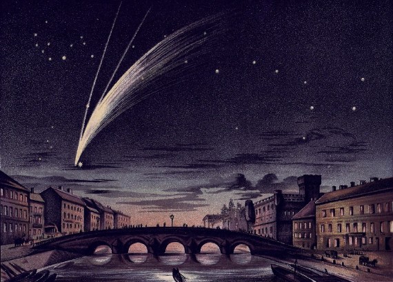
1018 a Comet appeared for 30 nights.
King Eogan (Owen II) (Owen the Bald) is recorded as being 'King of
Strathclyde' present at the
Battle of Carham
with 'Malcolm son of Cyneth, king of Scots'
(Malcolm II) and their victory over the Northumbrians . However, it is
believed that Owen the Bald died in this battle.
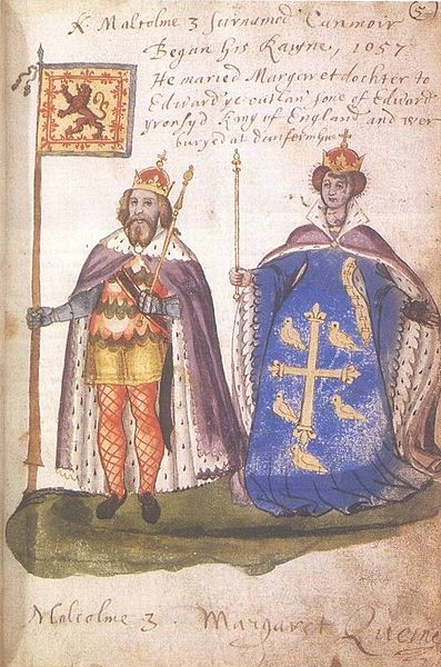
Duncan I
(grandson of Malcolm II and great grandson of
Cináed mac
Maíl Coluim (Kenneth II)) is installed in Carlisle as 'King of
Cumbria 'Strathclyde')
1021 Nennius writes
'The history of
the Britons'
1034
Malcolm II High King of Scotland
dies???/
1040 Duncan I was killed
at the hands of the famous
Macbeth,
King of Scotland from 1040-1057.
Scottish
occupation of Cumbria begins.

1054 An English invasion
led by
Siward,
Earl of Northumbria (a Scandinavian Viking by birth) had as its goal the
installation of Máel Coluim, (Malcolm III, eldest son of Duncan I)
"son of
the King of the Cumbrians".
It appears that
Siward temporarily succeeded and brought Cumberland, back under Northumbrian
lordship. The evidence comes from a document known as "Gospatric's Writ".
This is a written instruction, issued either by the future
Gospatric, Earl of Northumbria or Gospatric, son of Earl Uhtred) that
was addressed to all Gospatric's kindred and to the notables dwelling in the
"all the lands that were Cumbrian" (on eallun þam landann þeo Cōmbres);
it ordered that one Thorfinn mac Thore be free in all things in
Allerdale,
and that no man is to break the peace which was given by Gospatric and Earl
Siward.
After Macbeth had
been forced to relenquish Cumbria and Siward had
appointed Máel
Coluim, (Malcolm III, eldest son of Duncan I), as King of Cumbria, shortly
after Siward eventually departed, Macbeth returned and recaptured Cumbria
until Macbeth was killed by Malcolm III in 1057.
Macbeth's stepson
Lulach was King of Scots
and Cumbria from 1057-1058 when he was
assassinated by
King Malcolm
III the eldest son of Duncan I,
who became King of Scots and Cumbria from
1058-1092.

1066 Southern England was
invaded and conquered by the
Norman William
the Conqueror. The last Saxon
King of England Harold Godwinsson killed.
1069 King William's
position seemed weak with invading Danish armies and Malcolm III of Scotland decided on
war and took his Army South into Cumbria and across the Pennines attacking
Northumbria.
1070 Cumberland was stated in the Anglo-Saxon
chronicles as being "under the 'dominion' of
Malcolm III, that is not possessed by right, but subdued by force."
1070 at the command of
William of
Conqueror, who was seeking reprisal, forces were sent
to raid Scotland through Cumbria. Capturing great booty after much slaying and burning. This is
known as the Norman
Harrying of the
North and was a 'scorched earth' policy, with over 100,000 killed in
Northern England either
directly or through famine that winter, so bad that even Cannabalism was
resorted to by survivors. (Chronicles
of Florence of Worcester p.174)
King Malcolm III
gazed upon the burning church of St.Peter (in York? York Minster?) and heard what
William's men had done to his subjects, raged and
ordered all English to be slain or enslaved. Old men and women were beheaded
by swords, babies were tossed high in the air and caught on spears thrust
closely together in the ground. Youths and girls were taken as slaves to
Scotland.
1072 William of Normandy mounted an expedition
into Scotland and 'reduced it under his own dominion' so much that Malcolm
III gave him homage and declared peace.
1079 Malcolm III ravaged Northumbria again.
1086 Norman Domesday Book survey, Cumberland is
not included as it wasn't under their control at this time.

1092 Carlisle is captured from Scotland by King
William Rufus, son of William the Conqueror and
Cumbria is incorporated back into England. Flemish settlers and land holders
from Lincolnshire encouraged into areas near Carlisle i.e. Flimby (Flemingby). Local Norman Baronies
established including Greystoke. Dolfin Lord of Carlisle and son of
Gospatric is expelled. First Norman ruler of Cumbria is Ivo Taillebois.
1093 Construction of Carlisle Castle, Norman
Motte & Bailey design begins. Base for Norman (French) soldiers and too
difficult for locals to overcome. Malcolm III invades Northumbria again.
King Donald
III (son of Malcolm III) succeeds to Scottish throne following the death
of his older brother Malcolm III and Malcolm's son Edward in Northumbria at
the Battle
of Alnwick
c.1130 Cumbria granted to Scotland by English
King Henry III
1133 Original
St.Andrews Church established in Penrith.
[Present day church building built in 1720, older tower is original from
12th or 13th century]
1167 The earliest surviving reference to modern
Penrith is in the pipe rolls of 1167 for 'Penred Regis'
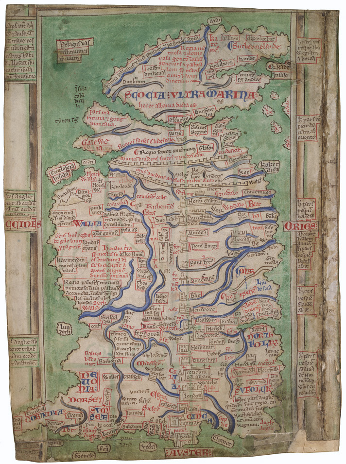
1250
Map of Britain
1272 Hutton Hall Pele Tower built in Penrith,
still standing today 2013.
Hutton Hall Pele Tower, Penrith in
May 2013. A Grade II listed building. Probably the oldest surviving building
in the town, predating the castle. Note the extremely small original windows
and the much later additions of chimneys. Also the white lime wash, roof not
original.
1290 Records showing place name 'Penreth'
(Modern name Penrith)
1295 Cumbria re-established as part of England
1296 Fire Beacon on Penrith Fell, now called
Beacon Hill. [First known year of beacon use at this location above
modern Penrith, then called Penreath]
1297 Large Scottish raid, looting, pillaging,
raping and bloodshed. Children pierced with spears etc.
1307 Brougham Hall
near Penrith is crenulated (given permission to fortify)
1314
Edward Bruce brother
of the Scottish
'Robert the Bruce' invaded the Eden Valley with an army and burned
Penrith.
Edward Bruce stayed three days at the
Carlisle bishop's
house at Rose, while he sent the greater part of his
army to burn all the surrounding towns and churches,
take captives, and lead away the cattle they should find
in the
Forest of Inglewood and its neighbourhood.
They struck no blow at Carlisle, because it was so well
manned. They must have emptied the bishop's fish-
ponds and driven away his deer in their course, for in
1319 Edward II. gave an order for him to have fifty
pickerels from the king's lake of Ternewathelan, in
the
Forest of Inglewood, for stocking the fishponds at
La Rose, and to have twelve hinds and twelve does
from that forest for stocking his park there, as these
had been destroyed by the Scots.
1315 Carlisle surrounded for 10 days, but Scots repulsed.
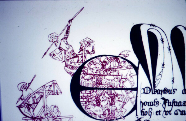
The drawing illustrates Sir Andrew de
Harcla's defence of Carlisle in 1315.
Sir Andrew de Harcla's
Defence of the City as told by the Lanercost Chronicle.
A. D. 1315. Shortly afterwards also in the same
year, on the feast of St. Mary Magdalen, came the King of Scotland towards
Carlisle, having assembled all his forces, and surrounding the city for ten
days, he besieged it, treading down all the corn, and wasting the suburbs
and every thing round about, and burning the whole country; and carrying off
with his army a very great booty of cattle from Allerdale, Copeland, and
Westmorland. Moreover, on every day of the siege, they made an attack on
some one of the three gates of the city, and sometimes on all three
together; but not with impunity, for darts, arrows, and stones, as well then
as at other times, were cast down upon them from the walls in so great
abundance, that they questioned among themselves, whether the stones did not
increase and multiply within the walls. But on the fifth day of the siege,
they erected an engine for casting stones near the church of the Holy
Trinity, where their King had placed himself, and continually threw great
stones towards the Caldew gate, and at the wall, but did no injury, or but
little to those within, except that they killed one man. There were, indeed,
within the city, seven or eight similar engines, with other warlike
instruments, called Springaldes, for throwing long darts; and slings in
sticks for casting stones which greatly terrified and annoyed those who were
without the city. In the meanwhile, the Scots erected a great berefray, in
the manner of a tower, the height of which considerably exceeded that of the
walls; which being observed, the carpenters of the city erected a wooden
tower, which exceeded the height of the other, upon one of the towers of the
wall, towards which that engine must have come, if it had approached the
wall; but it never drew near to the wall, for when it was drawn upon wheels
over moist and clayey ground; there it stuck by reason of its weight, nor
could it be drawn any further or occasion any inconvenience.
But the Scots applied many long ladders which
they had brought with them, for the purpose of ascending the wall in the
same manner in different places, and a sow for undermining the wall of the
city, if they found it practicable; but neither the sow nor the ladders
availed them any thing. They also made bundles of straw and grass in great
abundance, to fill up the moat without the wall, on the east side, in order
to pass over it dry; they also made long wooden bridges running on wheels,
that being drawn forcibly and rapidly with cords, they might be carried
across the ditch: but neither would the bundles, during the whole stay of
the Scots there, fill up the moat, nor those bridges pass the ditch, but
fell by their weight to the bottom.
On the ninth day of the siege, when all the
engines were ready, they made a general assault on all the gates of the
town, and attacked valiantly throughout the whole circuit of the wall, and
the citizens defended themselves as valiantly; and in the like manner, on
the following day. Moreover the Scots employed a stratagem similar to that
by which they took the castle of Edinburgh; they caused the greater part of
their army to make an assault on the eastern part of the city, against the
place of the friars minors, that they might draw thither the party within;
but the Lord James Douglas, a valiant and wary soldier, with certain of the
more bold and alert of the army, posted themselves on the western side, over
against the place of the canons and preaching friars, where, on account of
the height [of the walls] and difficulty, an attack was not apprehended, and
there erected long ladders which they ascended, and they had archers in
great numbers, who discharged their arrows thickly, lest any one should
raise his head above the wall: but, blessed be the Lord, they found such a
resistance there, that they were thrown to the ground with their ladders,
and there and elsewhere about the walls, some were taken, some slayn, and
others wounded. Yet no Englishman was killed during the whole siege, except
one man struck with an arrow, and the one above mentioned, but a few were
wounded. Thereupon, on the eleventh day, that is to say, on the feast of St.
Peter ad vincula, the Scots, either because they heard of the approach of
the English to raise the siege, or because they despaired of making any
further progress, early in the morning returned into their own land in
confusion; leaving behind them all their warlike engines above mentioned.
Certain English pursuing them, took John de Moray, who in the
before-mentioned battle at Strivelin, had for his share 23 English knights
besides esquires, and others of lower rank, and received a great sum for
their ransom: they took also with the aforesaid John, the Lord Robert
Bardolf, a man certainly of the very worst disposition towards the English,
and brought them both to the castle of Carlisle.
1340 Bishop
Strickland founds Grammar School in Penrith
c.1341 Mallerstang Castle (Pendragon Castle)
burned down by Scottish raiders
1345 Penrith attacked by 30,000 Scottish raiders and
burned. Many inhabitants carried off into slavery.
1362
Penrith (Penreth) named
in grant made by Edward III, and subsequently confirmed by Richard II.:--
"For the men and tenants
of the manors of Penreth, Salkeld and Soureby.
"The King to all whom these presents may come greeting.
"The men and tenants of the manors of Penreth, Salkeld, and Soureby,
which are of the antient demesne of our crown, dwelling within our
Forest of Inglewood, have besought by their petition, before us and our
council in our present parliament exhibited, that, whereas they,
forasmuch as their lands and tenements, for which they are bound to pay
us a great farm, by our enemies of Scotland are frequently destroyed and
laid waste, as well as the corn there in these lands growing by our
beast of the forest aforesaid in like manner, so that they will be
unable to pay us the aforesaid farm unless assistance be afforded to
them, we being willing to grant to them in aid of their said farm, that
they should be able to have to them and their heirs for ever, common of
pasture for all animals in the aforesaid forest. We, considering the
premises, and forasmuch as it hath been testified before us in the same
parliament, that the same premises do contain contain the truth, being
willing to do special favour to the same men and tenants, have granted
to them for us and our heirs, that they and their heirs shall have and
hold common of pasture for all their animals, within the forest
aforesaid, for ever, as the Prior of Carlisle, and William English, and
other tenants within the forest aforesaid, do have common of pasture
there of the grant of us and our progenitors without hindrance
impediment of us or our heirs, our justices, foresters, or other our
bailiffs, and ministers of the forest whatsoever.
"Witness the King, at Westminster, the 26th day of October, 1362."
1380 Scots raid Cumberland, bypass Carlisle
and attack Penrith carrying off loot and many prisoners.
1385
Penrith attacked by Scottish raiders and burned again. Most
buildings still made from wood, very few stone buildings due to cost.

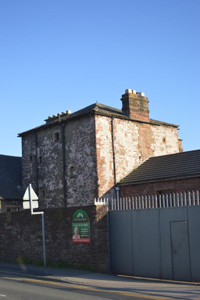
c.1397
Penrith castle construction began in 1397
or
1399
believed by
Ralph de Neville, first Earl of Westmorland having been granted Penrith
town and manor by
King Richard II.
c.1400
Bishop
William Strickland had a new fresh water course Thacka Beck artificially made running
through Penrith from the River Petteril to the River Eamont. The amount of
water permitted was that could be run through the eye of a mill stone.

1419
Bishop William Strickland dies.
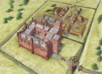
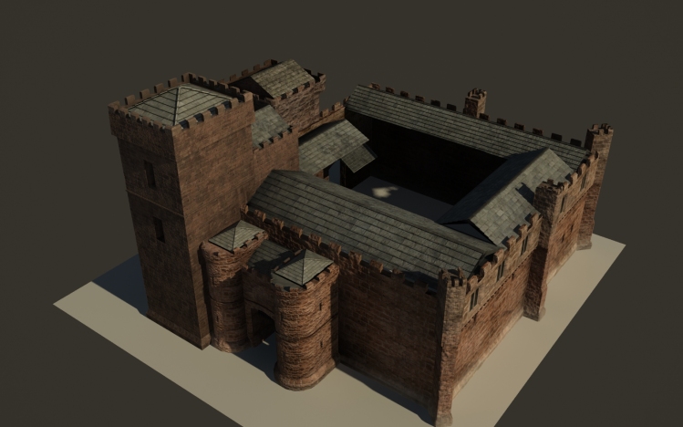
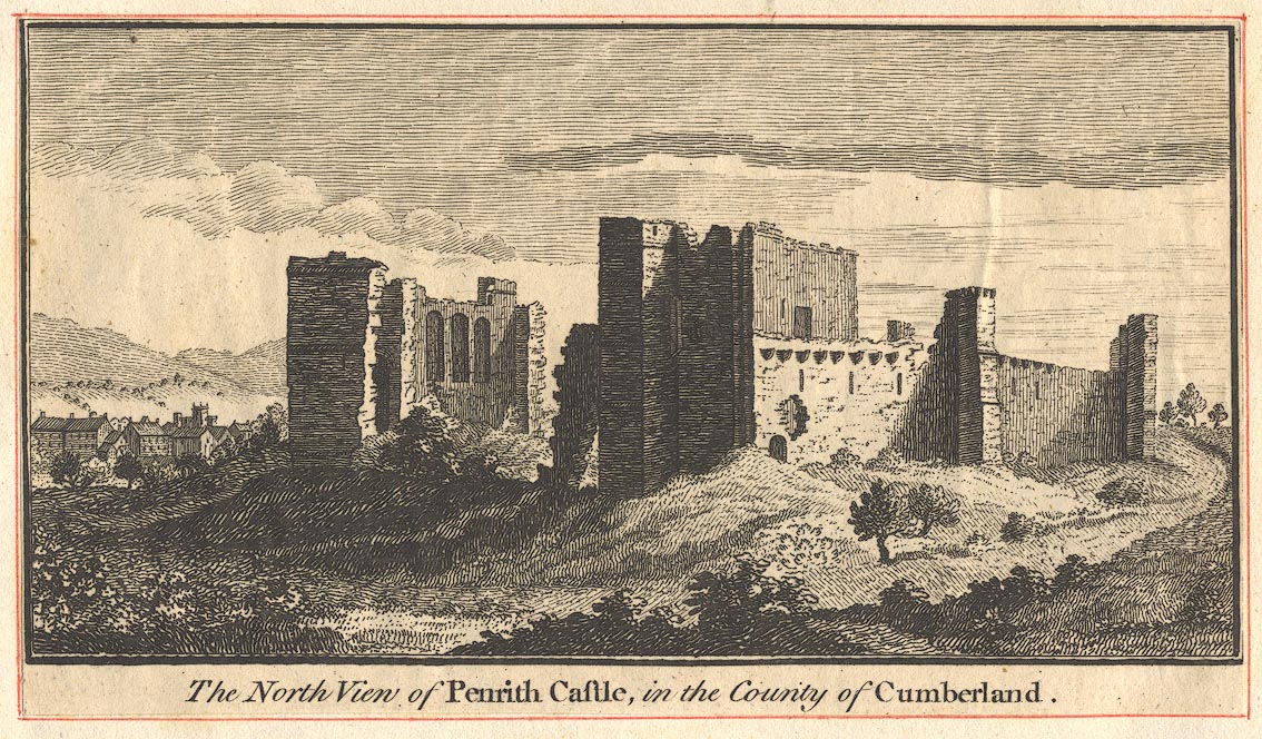
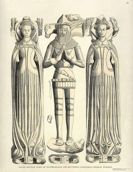
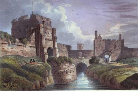
The castle depicted in about 1430
showing the buildings as they appeared after alterations made by Richard
Neville, Earl of Salisbury. (Drawing by Roger Hutchins) Courtesy of English
Heritage
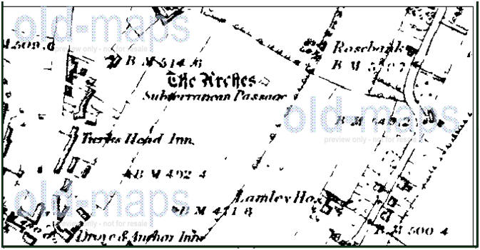
[There
continue to this day to be strong local rumours of a 'secret tunnel' leading
from the Castle. I have found few written references apart from a book
called 'The beauties of England and Wales, or Delineations' dated
1802, Volume 3, page 157 mentions
'an arched
subterranean passage is reported to lead from the castle to the lower
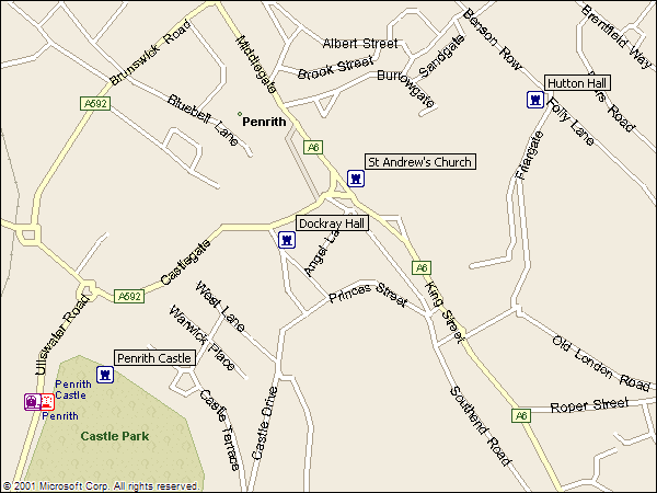
apartment of a house in the town called Dockwray Hall; a distance of 307
yards'. Another 1801 book says the passageway
connected to the Hall's kitchen and was 307 yards long. This tunnel
apparently running from Penrith Castle to what was until 2016 named the
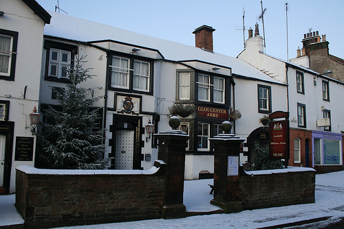
Gloucester Arms Pub, a c.1580 coaching inn
(formerly Dock(w)ray Hall c. 1471 then
a pele tower) in Great Dockray, Penrith.]
Apparently the 'secret tunnel' may run from the Hall kitchens/apartments, but has
never been seen in at least the past 200 years, although I did read one
relatively modern account providing a clue regarding 'Lancaster & Carlisle railway'
line workers in the 19th Century
sometime around
1846 "About 20 yards east of the castle wall was a hollow filled with
water; a gavelock (iron bar) was struck through the bottom of it into an
open space below. The water ran through the hole and disappeared."
Another local Penrith tale
tells of a time when some ducks swimming at the castle moat disappeared down
a hole in the ground and ended up in the kitchen cellar of Dockray Hall.
Apparently in the 1930's when
the new Neville Avenue (between the Castle and Dockray Hall) was being built
workers may have discovered the tunnel, but I can't find any pictures or
newspaper articles of this.
In April 2016 a potential
clue to the secret tunnel route and possible existence appeared when a
section of the car park to the rear of Dockray Hall sunk about 20cm into the
ground, the resulting depression being approximately 1.5m long and in line
with the car park wall in the direction of the castle. This depression may
be the roof of the tunnel beginning to collapse as at the bottom of the hill
it is likely to not be far beneath ground level.
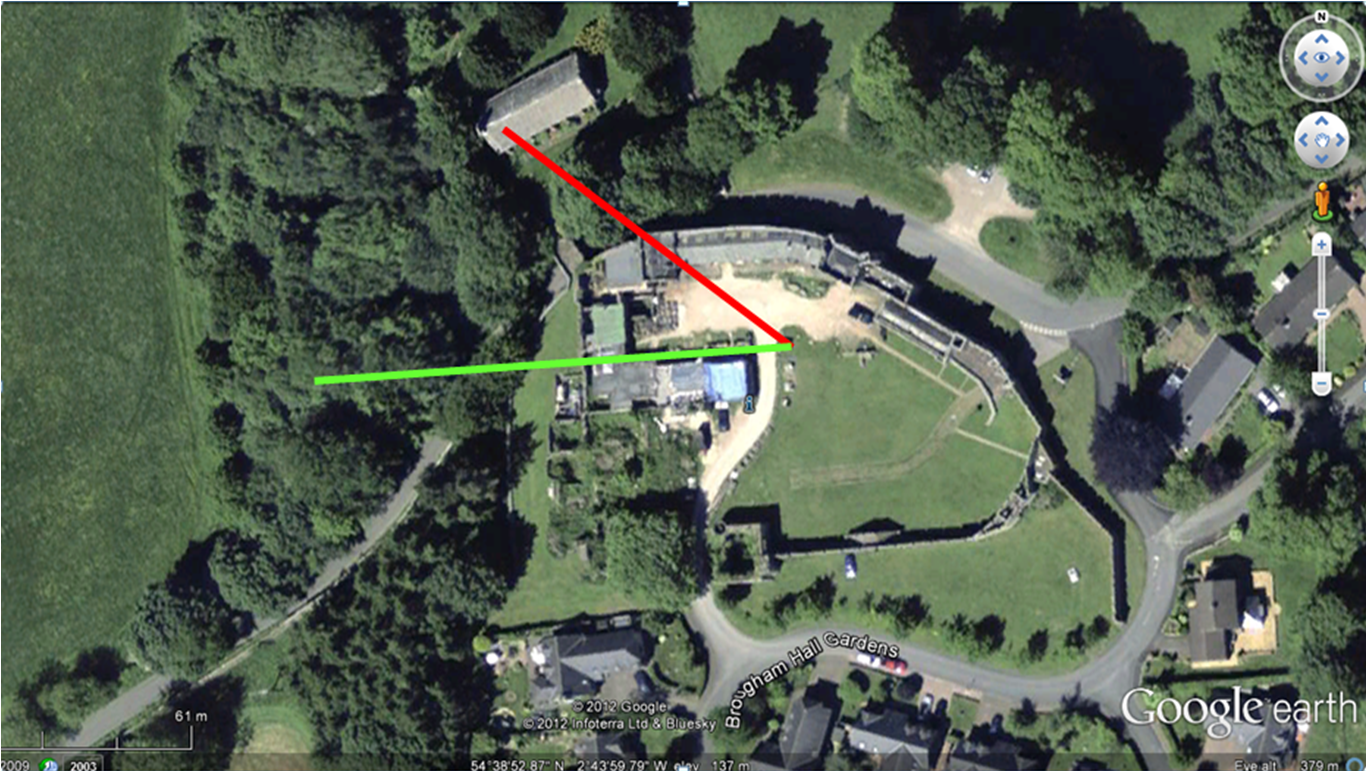
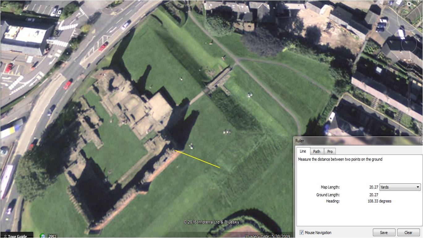
Looking at all these clues
and using Google Earth satellite imagery found a visible depression East of
the castle walls that might be the the railway workers referred to. Using
the 307 yard length from the Castle to Dockray hall and lining up the new
ground depression and this hollow, the possible path of the 'secret tunnel'
shows it as not being simply the shortest straight line between the two but
more of dog leg shape. See images below. However digging such a tunnel woudl
have required considerable effort and at a depth below that of the moat,
therefore the shortest path would have been from the Castle apartments to
Dockray Hall, but this is much less than 307 yards, see castle plan.
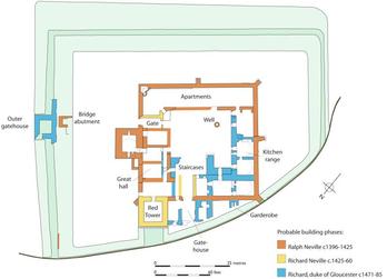
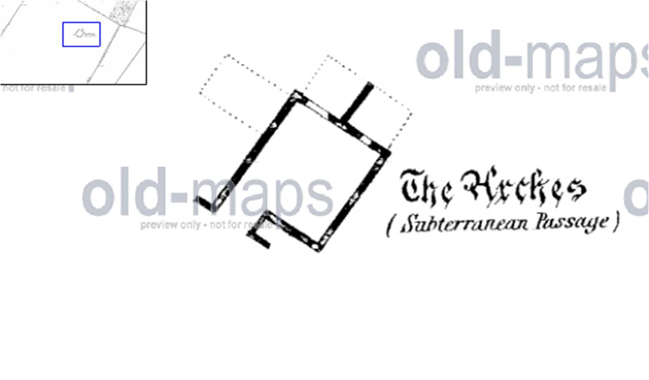
Plan of
Penrith Castle showing location of apartments

This old Penrith map, shown below &
date unknown, shows Penrith Castle with only fields between it and Dockray (Dockwray)
Hall. This lends credibility to it being possible to have built a tunnel
linking the two, with no buildings shown to obstruct the tunnel path.
The castle plan below needs to be rotated 90 degrees
clockwise to match the drawing with the satellite photo views.
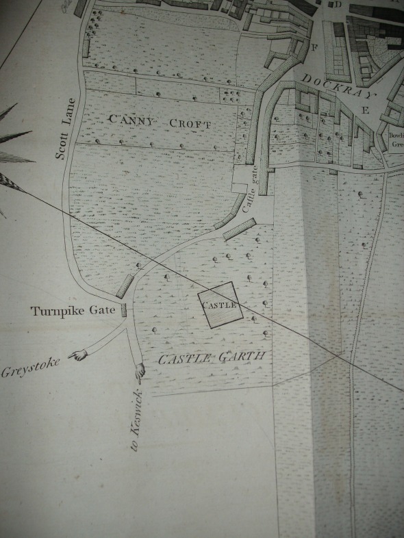
Old Penrith Map, courtesy of
Emily Knox
I would have
imagined that this tunnel would be no more than 2m beneath the top soil
level i.e. it would have been simply constructed by digging a ditch and
lined with stone, then soil and turfs replaced to hide it from view.
Obviously locals would have seen this construction, so is that why rumours
of its existence remain today including the tantalising precise description
of an 'arched subterranean passage'?
The trickiest part would have been
going underneath the Castle's dry moat, which is 6m deep, but that too could
have been achieved using a stepped tunnel at the same depth beneath the top
soil. In the Google satellite image there are clearly modern buildings built
over the likely tunnel route (if it exists) that surely would have uncovered
the tunnel when digging out foundations?
1468 Penrith beacon recorded as
communicating with one at Kirkoswald. Could also link with Carlisle Castle
High Tower to the North and Orton Scar to the South.
Penrith Castle
was finished in around 1470 as
a major defence against the Scottish raids. Prior to the castle being built
with its later moat, there may have been a Pele tower on the same site.
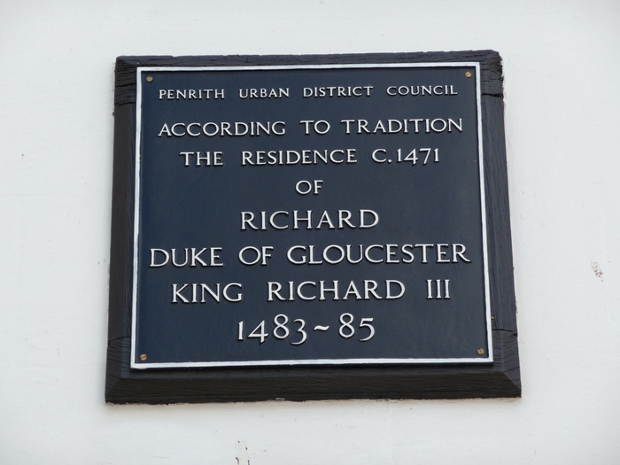
King
Richard III of England when he was the Duke of Gloucester
between 1461-1483 apparently stayed at Dockray
(Dockwray) Hall
whilst 'castle alterations' were made, after he was given the castle in
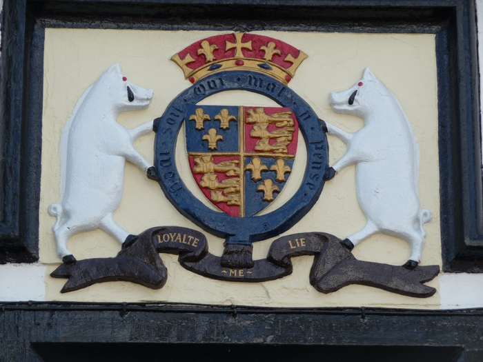
1471, aged only 18 or 19. His coat-of-arms was much later carved
into the stonework of the later built pub as a tribute to him having stayed there a
Century earlier.
It is highly likely therefore that the secret underground passageway was
created on the orders of Richard III a year after Penrith Castle completion in
1470, as a secret escape route, this was during
the period known as the
Wars of the Roses,
fought between the Armies of the Houses of York and Lancaster. Richard III
sometimes resided at Penrith Castle between 1471-1483
prior to being crowned King after the death of his brother. It was on the
14th July 1471 that he gained the Lordship of Penreth in Cumberland. His
main residence being
Middleham Castle in Wensleydale, Yorkshire.
In 2013 I found another account written in 1840 of this passageway/tunnel as 'There is the
commencement of an arched subterranean passage at Dock-ray Hall which is
supposed to lead to the castle'. [Does the word 'commencement'
in this context suggest that the tunnel was started and not finished, or does it mean the
entrance to a tunnel that was completed?]
I wish Tony Robinson and the
Time Team
would base themselves in the Gloucester Arms pub and
uncover the secret passage. Interestingly I have found an 1892 account of Dockray Hall
(earlier spelling was Dockwray Hall) saying that the portion of the then separate tenement,
(with the
inscribed 1580 date), originally contained the kitchens and apartments, so it looks like the secret
passageway does run from underneath the current Gloucester Arms pub. The original Dockray Hall was apparently demolished in the mid 19th Century and no longer exists,
but does appear on early 19th Century maps.
"Dockray Hall is closely associated with the castle, and
probably existed prior to its being built, forming the residence of Ralph
Nevill when he erected the castle. Similarly, we find, at a later period, a
branch of the Lowther family resident at the "Two Lions Hotel," which is
known to antiquarians as "Gerard Lowther's House," and a branch of the
Musgrave family at Musgrave Hall. Uniform tradition has established a
subterranean passage between Dockray Hall and the castle, but both the
entrances have been lost sight of, though a place in the cellar wall, in the
hotel, is pointed to as covering the entrance from that end. Many stories
have been current as to this passage, and of these the last is that some
ducks, belonging to the cottages, were lost at the castle, which turned up
in the cellar of the hotel. Of course that was before the cellar entrance
was built up. This passage, thus existing, was used for the purpose of
receiving supplies, and also as a means of escape when danger threatened.
The walls of the hotel bear testimony that it was not built for an ordinary
residence, but as a place of strength, the walls being in some parts as far
as nine feet thick."
King Richard III was
killed aged 32 at the battle of Bosworth in 1485. His body has only recently
been discovered in 2012 under a council car park in Leicester.
c.1485-1509 larger
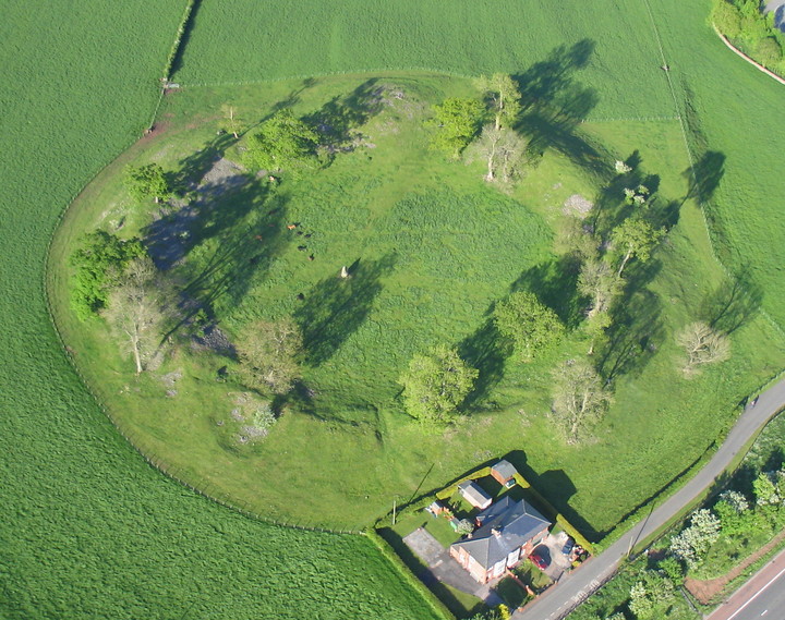
stones removed from Mayburgh Henge to repair Penrith castle.
1536 Martial Law declared in Cumberland by Henry VIII due to the Catholic
clergy including Bishop of Carlisle rebelling and attempting to March to
London to overthrow him.
The north of England at
once rose, and under the banners of St. Cuthbert and
the Five Wounds marched south, with Robert Aske as
their leader, in the Pilgrimage of Grace, " to go to
London on pilgrimage to the king's Highness, and
there to have all the vile blood of his Council put from
him and all the noble blood set there again ; and also
the faith of Christ and His laws to be kept, and full
restitution to the Church of all wrongs done unto it."
The punishments meted out to the lay rebels were
far more severe, and more in keeping with the Tudor
nature. Martial law was proclaimed in Cumberland,
Westmorland, Durham, and North-west Yorkshire ;
and Henry VIII. wrote to say that Clifford and Dacre
were to cause "such dredful execution to be doon
upon a good nombre of th' inhabitants of every toune,
village, and hamlet, that have offended in this rebellion,
as well by the hanging them up in trees, as by the
quartering of them and the setting of their heddes and
quarters in every toune, greate and small, and in all
suche other places, as they may be a fearfull spectacle
to all other hereafter, that would practice any like
mater."
Dumfries in
Scotland was burned again by the English in 1536, and was then revenged by a
Lord Maxwell. That nobleman, with a small body of retainers, made an
incursion into England, and reduced Penrith to ashes.
1542 24th November, 1542 Battle of Solway Moss. A Scottish Army of
15,000-18,000 marched South towards England and were halted by an English
Army of 3,000 at Solway Moss near Carlisle. The much greater Scottish Army
was routed by the smaller English force.

1547
large quantities of
stones were taken from Penrith castle to build a local prison [the prison referred to
is the old lock-up near Lark Hall, Townhead]
1563 there were apparently only 140
households in Penrith.
1564 Penrith Grammar School was
founded by Queen Elizabeth I and remains
in use today as QEGS, moving to its present location in 1917 from next to
St.Andrews Church.
1565 the Penrith castle was in ruins, the
lead roof had leaked considerably. Stone continued to be taken to build other buildings.
1572 Survey of Penrith Castle ordered by Queen
Elizabeth I
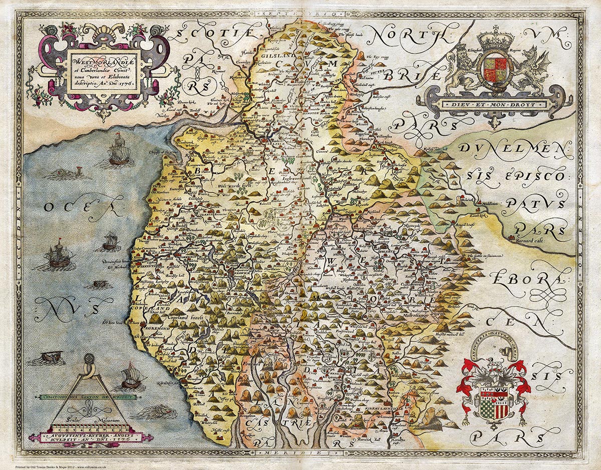
1576 Saxton's Map of Cumberland created
c.1585 Mr.Page headmaster of Penrith Grammar School meets a stranger,
a visiting gentleman, who had arrived in Penrith to visit some of its
antiquities. The stranger produced a sheet of paper and said that Sir Owen
(Hugh) Caesarius had a hermitage somewhere thereabouts called 'Sir Hugh's
parlour' and this place was some time afterwards opened by a William Turner
who there found 'the great long shank bones of a man and a broad sword'.
Was this the
Giants grave? Or some other location associated with Owen Caesarius such as
the caves on the River Eden?