
 HF Radio Propagation Planning Tools
HF propagation tools use monitoring, forecasting, and prediction to help plan your contacts by optimizing frequency selection and timing. By combining these methods, radio operators can make informed decisions about when and where to transmit for more reliable long-distance communication.
- Monitoring → Forecasting → Prediction
- Monitoring current conditions and Planning HF QSO within the upcoming minutes
- Forecasting: Planning HF QSO for the next 24 hours
- Prediction: Planning HF QSO for longer periods
Monitoring: Figure 1 (below) presents the calculated current regional propagation conditions (F2 region MUFs), which are quite useful for planning within the upcoming minutes.

Figure 1: MUF 3000 km Propagation Map, by Andrew, KC2G
This map does not take into account terrain or ionospheric dynamics.
How to use this map | Important notes | Animated map
An Open-Source IRI-based Nowcasting Tool for Ionospheric Electron Density and HF Propagation Andrew D Rodland (2022 Harvard Abstracts)
An overview of the software and the models behind prop.kc2g.com, a website using the IRI-2016 model, conditioned on near-real-time ionosonde data, to provide global maps of MUF(3000) and foF2. While primarily designed for radio amateur use, this system is useful for nowcasting of F region ionospheric density and mesoscale low elevation HF propagation characteristics.
Point-to-Point 24-Hour HF Propagation Planner
Andrew D. Rodland, KC2G, offers a free application called "HF Propagation Planner." This is an HF propagation planning and forecasting tool, similar to Proppy's Radcom Predictions. While prediction tools rely on "global monthly average" ionospheric conditions, this "HF planner" makes a regional short-term forecast using real-time data. It checks your current local HF conditions and schedules your QSOs for the next 24 hours. ↗
User guide with demo:
The charts below (Figure 2) show the forecasted HF conditions for a planned SSB QSO from Karmiel, Israel (QTH locator: KM72pw), to twelve different locations around the world in 24 hours.
These are the estimated signal strengths and communication reliability from Karmiel, Israel, to a dozen destinations. The calculation was performed on August 25, 2025.

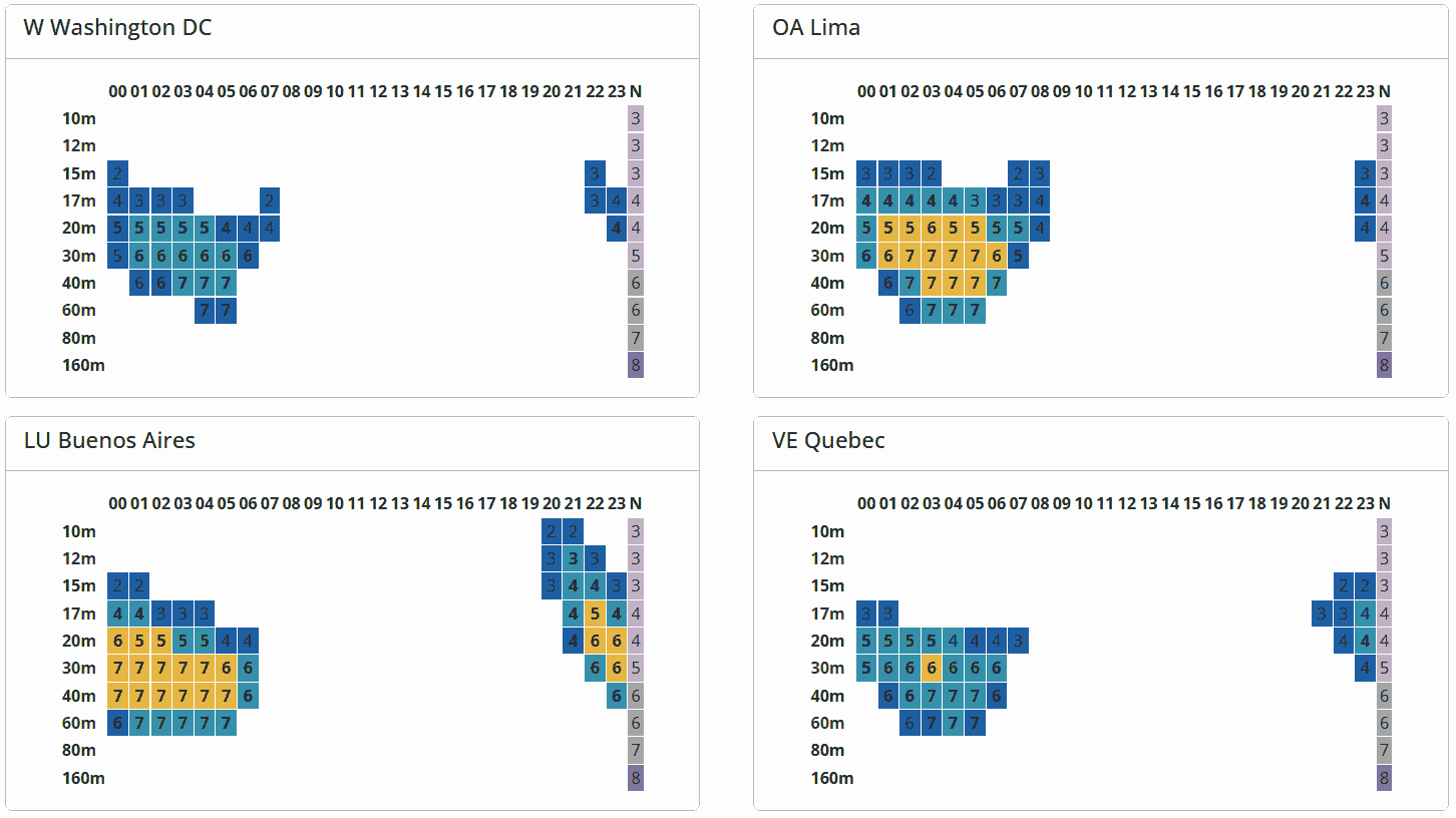

Figure 2: Forecasting radio signal strength and reliability charts from Karmiel, Israel, to a dozen destinations
A number within a square represents estimated signal strength in S units, while color indicates reliability (BCR). The chart includes hourly columns and amateur radio band rows that assess the likelihood of successful communication in SSB mode, with bold numbers exceeding predicted manmade noise levels. The right column, N, represents noise S-units.
Input variables:
TX: 100W SSB.
RX residential noise is -145 dBw/Hz at 3 MHz. BW=3000Hz / SNR=6dB
Antenna: Vertical, 2.16 dB gain.
Local time is used in this example (UTC is the default).
Users can customize antennas by selecting the type and height above ground. The "Custom Site" feature now includes one more RX site in its list. Actual band conditions may vary. This tool is useful for both casual and organized contest weekends. The mention of varying band conditions highlights the importance of real-time adjustments and considerations in radio communications. This ensures users can optimize their setup based on current environmental factors for better performance.
Planning HF QSO for longer periods
- S/N HF propagation forecast calculator on 8 bands for the current month DL0NOT
- The Advanced Stand Alone Prediction System (ASAPS) ASWFC
Australian Space Weather Forecasting Centre offer three software products to predict HF propagation:
1. GWPS - designed for HF operators working in defence and emergency services
2. ASAPS Kernel - The Advanced Stand Alone Prediction System designed for government, defence and emergency services
3. Consultancies - designed for industry, defence and emergency services - Proppy HF Circuit Prediction: RadCom's monthly propagation predictions James Watson, M0DNS
- Proppy Online - HF Propagation Prediction James Watson, M0DNS
- Proppy HF Circuit Prediction: NCDXF/IARU Beacons James Watson, M0DNS
- DR2W - Predict Propagation Conditions DK9IP (Winfried), DH3WO (Wolfgang), DJ2BQ (Ewald), ZS1AO/DJ2HD (Mathew)
A Long-term forecasting cannot take into account unpredicted ionospheric and magnetic disturbances or anomalies. -
The Voice of America Coverage Analysis Program, was created to help people receive VOA broadcasts. However, it has been expanded for HF and ham radio planning, including an azimuthal map to assist you in correctly aiming your antenna at the appropriate times and frequencies to make amateur radio contacts.
How to plan a QSO with VOACAP?
- Enter Your Station Parameters: Set your location, antenna type, power level, and receiving attributes using the VOACAP Online Point-to-Point tool.
- Select Your Target: Choose the location of the station you wish to contact using the interactive map.
- Click "Prop Charts": Generate hourly propagation charts for each band to assess signal reliability.
- Review the Coverage Map: View the probability of successful communication across regions via the Coverage Area Map.
- Use the "Prop Wheel": Visualize best times and frequencies for contact using the Propagation Wheel.
- Analyze Predictions and Adjust Your Strategy: If the probability is low, consider changing your operating time, frequency, or antenna setup.
VOACAP Resources
- VOACAP Homepage
- VOACAP Point-to-Point Tool
- VOACAP Primer updated 2021 James (Jim) Coleman, KA6A
- VOACAP Online Application for Ham Radio Jari Perkiömäki, OH6BG / OG6G
VOACAP forecasts monthly average of the expected reliability with diurnal and seasonal variations.
A Long-term forecasting cannot take into account unpredicted ionospheric and magnetic disturbances or anomalies. - VOACAP Quick Guide Jari Perkiömäki, OH6BG / OG6G
Voice of America Coverage Analysis Program
forecats monthly average of the expected reliability with diurnal and seasonal variations,
but it does not account for unpredicted ionospheric and magnetic disturbances or anomalies,
i.e. what are the expected variations of A-index, K-index, and energy densities of solar proton / electron flux, etc. - VOACAP Shortwave Prediction Software
 Rob Wagner VK3BVW
 - How to use VOACAP - Part 1: Overview, Part 2, Part 3 Jari OH6BG & OH7BG Raisa
- VOACAP DX Charts VOACAP
- VOACAP Charts for RadCom VOACAP
- RadCom online Propagation Prediction Tools RSGB
- IOCAP Introduction Video (2021) SANSA
The South African National Space Agency (SANSA) created i/o cap Primary Work Surface, an operational HF communication solution.
It's a modern, user-friendly HF frequency prediction tool that's simple to use and accurate. In a software program, it blends space weather research and practical HF experience. - Ionospheric Characterisation Analysis and Prediction tool (IOCAP) (2020) SANSA
- Ham CAP 1.91 freeware (2020) VE3NEA
The HamCAP software by Alex VE3NEA is a compact freeware interface program to VOACAP, incorporating both graphical Point-to-Point and Area Coverage predictions. - Evaluation of various models for HF propagation prediction (2016) SANSA Space Science, South Africa
- ITU-R P.533 model (2001) This is an ITU table links to Software, Data and Validation examples for ionospheric and tropospheric radio wave propagation and radio noise in a wide range of propagation conditions. The ITUR HF Prop experimental software, was written by G4FKH and HZ1JB, and is based on the ITU-R P.533 method. It uses a probabilistic approach to estimate radio coverage with algorithms that are supposed to be more accurate than other similar programs.
- Real-time TEC - Total Electron Content
- Refractive Index of Ionosphere Calculator Calculator A to Z
- NVIS HF signal propagation in ionosphere using calculus of variations (2018) Umut Sezen, Feza Arikan, Orhan Arikan; Turkey
Prediction Software
RadcomProppy
DR2W
VOACAP
IOCAP
Ham CAP
IcePac
Misc.
HF Propagation Forecast Bulletin
Shortwave propagation bulletin
Real time radio propagation map
Space weather status and alerts
HF propagation seasonal anomaly
Current Ham Radio HF Propagation
HF propagation status and alerts
Current solar conditions Ham radio
HF Radio Propagation Search Terms
Radio propagation seasonal anomaly
Skywave propagation seasonal anomaly
What is Radio Communication Circuit?
Current HF Band Conditions Online Map
Skywave propagation for hams explained
Current Ham Radio Propagation Conditions
How does the sun affect radio communication?
Real-time watching of worldwide ham activity
Real-time watching of worldwide activity of hams
HF propagation for hams explained
Radio propagation for hams explained
The Fascinating World of HF Skywave Propagation
The Path of Wireless Communication
Introduction to Wireless Communications
Current HF Bands Conditions—Charts for Radio Hams
Current HF Band Conditions Maps For Radio Operators
24-hour forecast for point-to-point communication circuit
___________________ Internal links ___________________Online radio planning software
RF path software free download
Radio Propagation Planning Tools
24-hour HF Propagation Prediction
Long-term HF propagation planning
HF Propagation Planner Application
Short-term HF propagation planning
RF propagation prediction software
Radio coverage simulation software
Radio propagation mapping software
RF coverage prediction software free
Plan HF communication on ham bands
Free RF propagation mapping software
Propagation prediction software ham radio
Plan your QSOs now, the next 24 hours and more
24-hour forecast for point-to-point communication circuit
Point-to-point 24-hour HF Propagation Planner Application
Plan your HF radio operations now, the next 24 hours and more
Free Online HF Propagation Tool for Technical and Non-Technical Users
HF propagation Global Conditions Charts
HF propagation Regional Propagation Maps
Global Conditions Charts of HF propagation
Regional Propagation Maps of HF propagation
Propagation of radio waves explained