
 MUF Propagation Map
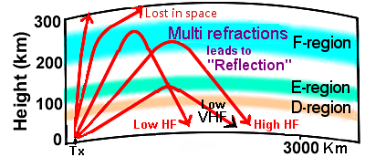
What is MUF? — Maximum usable frequency is the highest possible frequency (HPF) that supports communication between two points on Earth by refractions from the F ionospheric region at a specified time, independent of transmitter power.
The following map visualizes the current ionospheric conditions that affect global HF radio propagation, aiding radio operators in assessing optimal frequencies and communication paths.

HF Propagation Forecast Bulletin
Shortwave propagation bulletin
Real time radio propagation map
Current solar conditions Ham radio
Current Ham Radio HF Propagation
HF propagation status and alerts
HF Radio Propagation Search Terms
Current HF Band Conditions Online Map
Current Ham Radio Propagation Conditions
Real-time watching of worldwide ham activity
How does the sun affect radio communication?
HF propagation for hams explained
Radio propagation for hams explained
Real-time watching of worldwide activity of hams
The Fascinating World of HF Skywave Propagation
What is the Best Frequency for HF? FOT, OTF, OWF
Current HF Bands Conditions—Charts for Radio Hams
Current HF Band Conditions Maps For Radio Operators