
 Compare forecasting and predicting tools for HF radio propagation
Point-to-Point 24-hour forecast.
An excelent application courtesy of Andrew D Rodland, KC2G
This is an HF propagation planning—forecasting tool, similar to Proppy's Radcom Predictions. While prediction tools rely on "monthly average" ionospheric conditions, this planner makes a short-term forecast using real-time data.
Additionally, Andrew (KC2G) created the MUF300 map, which is an easy-to-use forecasting tool for monitoring online HF radio propagation in real-time.

The KC2G model does not account for geomagnetic storms and blackouts caused by elevated X-ray flares and/or proton ejections; the estimation's accuracy is insufficient for commercial radio service purposes. Read detailed explanations about these issues here.
There are several hundred ionosondes that can take measurements. The vast majority of these are concentrated in a few areas of the world, with large areas remaining unmonitored. As a result, that map is an interpolation. While the guessing process is fairly accurate in areas close to ionosondes, the uncertainty in areas far from any measurements is much higher. Only the numbers within the colored dots scattered across that map represent actual measured data.
Another tool to forecast band conditions is DXView.
This ia a real-time map of worldwide ham activity on ham bands designed by Jon Harder, NG0E.
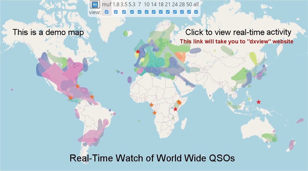
Figure 2: Real-time Ham Band Activity
This map reviews ham band conditions across the globe, refreshing every 15 minutes. It tracks real-time activity on 11 bands ranging from 1.8 to 54 MHz. Data comes from trusted sources (DX Cluster, WSPRnet, RBN ↗, etc.) that offer information on the signal-to-noise ratio (SNR) levels. The DXView website provides a guide on interpreting the map and selecting band colors.
The idea to predict HF propagation based on Ionospheric Monitoring and Prediction System has been described years ago. See for example this PDF.
The following applications can predict HF radio propagation (a few days, weeks and months in advance):
- VOACAP (Voice of America Coverage Analysis Program): This is the most popular program for predicting HF radio propagation for both point-to-point and area coverage. VOACAP uses historical solar and ionospheric data to predict the radio propagation over a specific path. Additionally, there are programs and tools used by radio hams and professionals. ↗
- ITU-R-HF-Prop :
- SWPC - The NOAA Space Weather Prediction Center offers a variety of space weather services. The SWPC uses data from various sources, including ground-based and space-based observations, to predict the ionospheric conditions and their impact on HF radio propagation.
- SWS Forecasting Center - The Australian Government Bureau of Meteorology's Space Weather Services provides real-time and near-real-time information on the state of the ionosphere as well as predictions of ionospheric conditions. This service measures and monitors ionospheric parameters like electron density, electron temperature, and ionospheric irregularities using a combination of ground-based and satellite-based sensors. All of these can be used to predict HF radio propagation.
This is an ITU-R recommendation that provides a method to predict the performance of HF radio systems in a wide range of propagation conditions. The ITURHFProp software, written by G4FKH and HZ1JB, is based on the ITU-R P.533 method and uses a probabilistic approach to estimate radio coverage.
Each of these tools/services has advantages and disadvantages, and the tool selected will be based on the user's specific needs and requirements. It should be noted that none of these services can provide perfect predictions because radio propagation is affected by a number of variables that are difficult to predict completely.
Read more about forecasting and predictions for HF radio propagation.
Real time radio propagation map
Current solar conditions Ham radio
Current Ham Radio HF Propagation
HF propagation status and alerts
HF Radio Propagation Search Terms
Current HF Band Conditions Online Map
Current Ham Radio Propagation Conditions
Real-time watching of worldwide ham activity
How does the sun affect radio communication?
Real-time watching of worldwide activity of hams
The Fascinating World of HF Skywave Propagation
Current HF Bands Conditions—Charts for Radio Hams