|
|


QRZ.COM |
AMSAT Site |
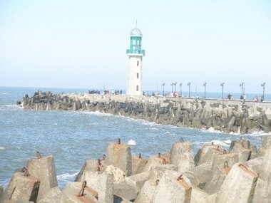
SU8LH DX-Pedition August 2009 The goal behind the activation of this lighthouse is to share with the radio amateurs all around the world the glory that this particular location symbolizes. This unique geographical location is where the longest river on earth finally pours its waters into the sea. These low lying shorelines along river deltas are the most vulnerable locations to the effects of global warming. The historic Ras El Bar lighthouse has been proudly standing up for a very long time in this location serving the maritime traffic in the Mediterranean. The question is how much time it can remain standing up in the face of the effects of the global climate change? |
EG0001 |
Ras El Bar City This dx-pedition will take place in Ras El Bar city which is administratively a part of the Damietta governorate and lies 250km to the north of the Egyptian capital Cairo. Ras El Bar city is a popular tourist attraction as it is the place where the 6695km-long Nile river finally meets the Mediterranean in a location called El Lisan. The waters of the Nile at this location would have made a long journey through ten African countries before reaching this point. Ras El Bar city dates back to 1823 and the name of the city in Arabic means the Head of the Shoreline, because it is the farthest protruding point of the Egyptian shoreline into the waters of the Mediterranean. The Ras El Bar lighthouse stands up proudly at this significant geographical point to guide the maritime traffic in the Mediterranean heading towards its locatio |
A R A B I C |
SU |
ARABI |
