Latest Release is an Beta:
Changes 3.1.6 - 9 May 2010
Now you can save all configuration settings as a textfile! Allows you to
later load a configuration
with different colours, zoom, propagation or whatever settings you had
when you saved the file.
When plotting squares you now can choose any textfile with locators,
like an adif file or any other file
with readable text and a locator somewhere in the line.
Changes 3.1.5 - 24 Jan 2010
Now you can show 4 different parameters for propagation. SDBW, SNR, MUF
or Reliability.
Added more input parameters for propagation.
Propagation txgain and rxgain where switched - fixed.
Shading can now be switched on and off from the toolbar.
Changes 3.1.4 - 13 Jan 2010
Collision detection when plotting text. You can also align the text to
the left, right, top or bottom.
You can also add a dot at the text position. Se som screenshots on the
linux page!
When you click ok on the option dialog - propagation and sunterm are
removed. Otherwise you could end
up in an infinite loop.
The input bitmap can now be of any supported type (jpg, bmp, png and
many others) Used to be only jpg.
Changes 3.1.3 - 5 Jan 2010
Propagation didn't work if you manually selected time and date -fixed.
Fixed slider for zoom in Linux.
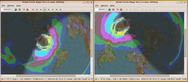
New possibility to plot a propagation file of your choice (made
externally or from another instance of gcmwin)
In the picture below I first plotted DM83PD with propagation and then
started another instance of gcmwin and
plotted external file (just made from DM83PD)
Also useful if you want to tweak settings to voacap. Run the normal
program voaarea, icearea in Windows or
voacap-GUI in Linux and then load the created vg1 or ig1 file in my
program.
Why? Well, in my program you don't have access to all parameters (not
yet anyway) like different antennas,
direction of antenna, noice level, etc
Thanks to Jari Pärkiömäki OH6BG (creator of Vocap-GUI for Linux) for
that suggestion!
See http://www.voacap.com for lots
of links and info!
Blue marble map (huge)
can be downloaded from Nasa
http://www.nasa.gov/vision/earth/features/blue_marble.html
Look at the lower right for link to maps (20 MB download). Resize it to
max 10000 pixels wide to be able to use it
reliably in GcmWin. If you are lucky to have 64bit system the size don't
seem to be a problem!
Night time map here:
https://svn.vidalia-project.net/svn/marble/trunk/data/maps/earth/citylights/citylights.jpg
An
overview of different map projections can be found here
http://www.csiss.org/map-projections/
Updated
pnt-files for borders (mine is very old..) can be downloaded from
http://www.csiss.org/map-projections/anderson/
Look
for "SSMap_Data.zip"
All included *.pnt-files can be plotted!
Wishlist and plans:
- Plot/Hatch squares from combo (Partly fixed in ver 3.0.5)
- Different maps for the day and night side of the earth
-
Didn't look nice. Better with shading...
- Use maps that don't cover the whole earth (if you want to zoom in
and plot only Europe for example)
- Do you have any suggestions?? Please Email me! Address at the top!
Features:
- Can make very good looking maps in the Azumuthal Equidistant
projection
- Very customizable
- Maps can be saved as bitmaps
- Settings are saved between sessions
- Lines and text can be transparent and coloured
- Clean and user-friendly interface
- Freeware
Disclaimer:
- No guarantee whatsoever that the program works
- It might even crash your computer
- Commercial use forbidden
- Since it is an beta version - dialogs and functionality might
change
Author and programmer:
|
|

