As if often quoted on the Interent and especially the APRS SIG, the policy of "RTFM" should always be followed! To that end, it is our recommendation that you take the time to not only READ the files, but PRINT them as well and keep them in a binder for ready reference!
APRS is the result of over 17 years of trying to use packet radio for real-time communications or public service events. Packet radio has great potential but so far has been best used for passing large volumes of message traffic from point to point or into the national distribution system. It has been difficult to apply packet to real time events where information has a very short life time.
APRS avoids the complexity and limitations of a connected network. It permits any number of stations to exchange data just like voice users would
on a voice net. Any station that has information to contribute simply sends it, and all stations receive it and log it. Secondly, APRS recognizes that one
of the greatest real-time needs at any special event or emergency is the tracking of key assets.
Included on the distribution disk are several README text files on applications of APRS such as for weather nets, direction finding, plotting satellite contacts, and monitoring DX clusters. You MUST read at least the README.1st, DEMOS.txt, NewNotes.txt and HELP.txt files.
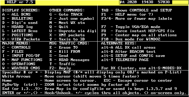
The template above is available by hitting the F1 key, then H then ENTER. This is a quick reference of the command set for APRS. It is a good idea to do a Print Screen of this page and post it next to your computer as a handy user reference!
There are three major display subsystems and a number of other minor displays as follows:
You can CLICK on any of the above list to see sample screen shots of each feature!
SPACE APPLICATIONS: APRS is a solution to the effective use of orbiting packet digipeaters. APRS capitalizes on this most fascinating aspect of the amateur radio hobby, and that is the display on a map of the location of those stations.
FOX HUNTING OR DIRECTION FINDING: APRS will display the intersection of bearing lines from a number of reporting stations and also overlapping signal strength contours if only signal strengths are reported. It includes the Fade-Circle Search and Rescue technique which can be used by a mobile with only an OMNI antenna to locate a hidden transmitter. There is an optional Dopler DF registration for direct connection to a Roanoke or Doppler Systems DF unit for automatically plotting and transmitting instantaneous DF bearings.
WEATHER STATION REPORTING: APRS position reports can also include the wind speed and direction, as well as other important weather conditions. All weather stations show up as a bright blue circle, with a line indicating wind speed and direction. APRS also has a database of the locations of most NWS sites for instant display and can also crunch a file of NWS hourly WX conditions and update all NWS stations on the map. Finally, users can set WX alarms and be alerted when WX conditions exceed those values.
DX CLUSTERS: APRS is an ideal tool for the DX cluster user: not only does he get to see all DX spots on the map, but by operating in the monitor only mode, he has reduced the overall packet load on the DX cluster. The APRS monitroing station will see the SPOT as soon as the first station gets it.
Most local APRS Networks in the United States use 145.79 MHz. Canada uses 144.39 MHz. there are also several HF frequencies to choose from.
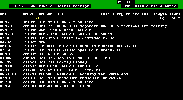
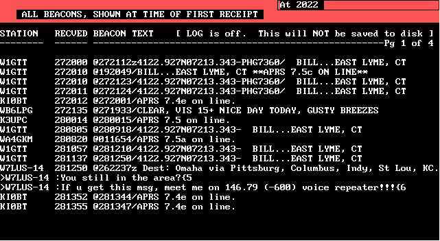
LATEST BEACONS - This display maintains a list of the latest UI frame received from each station. In effect, this is a multi-station one-line broadcast message system. In DX cluster mode, it accumulates a list of all users and what was their latest command to the cluster.
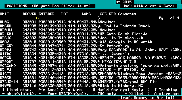
POSITION REPORTS - This display is a listing of up to five pages of actual station locations.
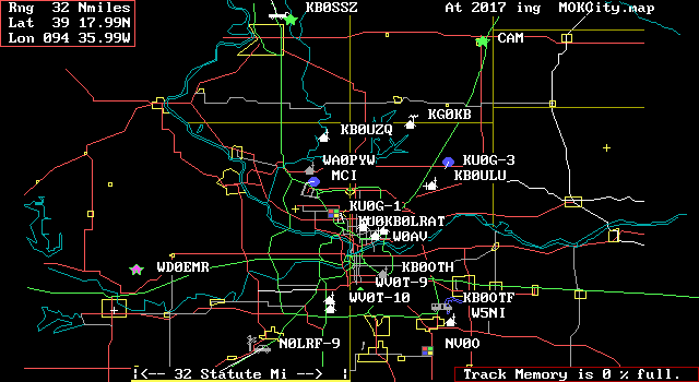
MAPS - Maps from .5 miles up to 2000 miles can be displayed. Stations that are transmitting a properly formatted position beacon will be plotted. Stations reporting a course and speed are dead-reckoned to their present position. A database of most National Weather Service stations is built in. You can zoom in to any point on the globe!
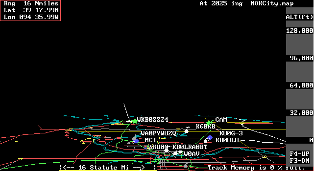
VERTICAL AXIS VIEW - By hitting the "Y" key, the map view is switched from an overhead to a horizon view which allows viewing of objects above ground such as aircraft and balloons.
MESSAGES - In addition to the BEACON text one-line broadcasts, there is an operator-to-operator message capability. Any station can send one line messages to any other station.
BULLETINS - This screen maintains a list of active all-net BULLETINS. BULLETINS allow one station to send multiple lines to the BULLETIN page at ALL stations.
TRAFFIC - This screen shows the last 23 lines of messages exchanged by any stations on the net. Is useful for "READING THE MAIL". DX mode TALK traffic also shows up here.

HEARD LOG - This page is an hour-by-hour display of the number of packets received from each station on the network.
DIGIPEATER LIST - This display displays the raw packet header so that APRS users can see what digipeater paths are being used by other stations. In DX mode, this list accumulates a list of all DX cluster messages monitored.
Page Updated JULY 19,1998.