|
Back |
BorderLand |
Home |
|
Extreme
points of the Netherlands
According
to the Statistisch Jaarboek
2000, published by
Centraal Bureau
voor de
Statistiek,
these are the extreme points of the Netherlands:
|
Highest |
321 meters above sea level (= N.A.P. = Normaal Amsterdams Peil) |
|
Lowest |
6,7 meters below sea level (= N.A.P. = Normaal Amsterdams Peil). |
|
Northernmost |
53° 52' 05" north latitude |
|
Easternmost |
07° 13' 14" east longitude |
|
Southernmost |
50° 45' 05" north latitude |
|
Westernmost |
03° 21' 31" east longitude |
|
The surface is 41.526 km2 |
|
The Netherlands shares 450 km. of border with Belgium and 577 km. with Germany (Source: The World Factbook - CIA).
|
Extreme
punten van Nederland |
|
|
|
The highest
point of the Netherlands is on the Vaalserberg in the province of Limburg. It is not far away from the tripoint Belgium/ Germany/ Netherlands. Photo's of this tripoint are elsewhere on my site.
|
|
Het hoogste punt van Nederland ligt op de Vaalserberg in de provincie Limburg. Het is niet ver van het drielandenpunt België/Duitsland/Nederland. Foto’s hiervan vind je elders op mijn website. Er wordt gezegd dat het echte hoogste punt een paar honderd meters verwijderd is van het gemarkeerde punt. |
|
|
|
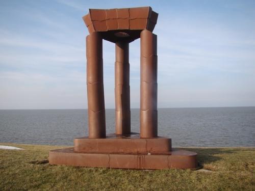
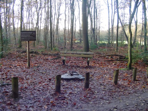
The lowest
point of the Netherlands. |
|
Het laagste punt van Nederland. Dit monument staat nabij 51° 59' 13" NB and 4° 38' 9" OL, in Nieuwerkerk aan den IJssel in de provincie Zuid-Holland en is opgericht op 18-04-1998. Hier is een gebied van 1 hectare gemiddeld 6,74 mtr. onder N.A.P. Na herziening van het NAP is de nieuwe officiële hoogte NAP – 6,76 ingaande 1-1-2005. De vorige recordhouder, Prins Alexanderpolder verloor zijn positie door bouwactiviteiten. Link naar info. |
|
|
|
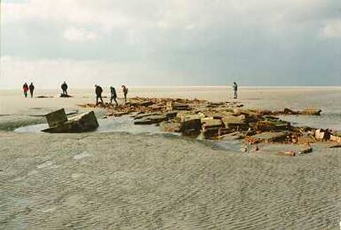
Northernmost
point. |
| Het noordelijkste punt. Het noordelijkste punt ligt eigenlijk is zee, maar dit is waar je op land zover als mogelijk noordwaarts kunt gaan. De foto toont de restanten van de woning van de voogd van het eiland Rottummeroog, die bij laag water zichtbaar zijn. Het eiland is een natuurreservaat en alleen tijdens excursies toegankelijk. Alleen op het nabij gelegen eiland Rottummerplaat kun je nog verder noordelijk komen. Helaas is de toegang tot dat eiland streng verboden. | |
|
|
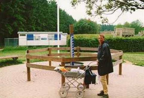
Northernmost
point of the Netherlands'
mainland.
|
|
Het noordelijkste punt van het vasteland van Nederland. Ten noorden van Uithuizermeeden. Het wordt gemarkeerd door het kunstwerk "De Hemelpoort" van René de Boer. |
|
|
|
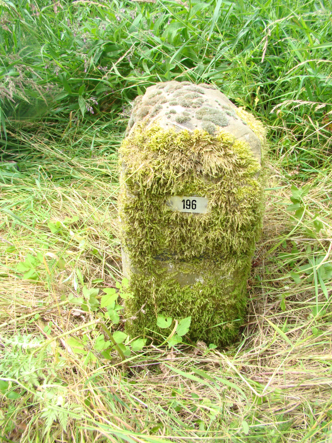
Easternmost point.
This
point is at border marker 196 along the A7 motorway/ Bundesautobahn 280.
2009-06-27 |
|
Oostelijkste punt. Dit bevindt zich bij grenspaal 196 langs de A7/Bundesautobahn 280. Nabij Nieuweschans (NL) |
|
|
|
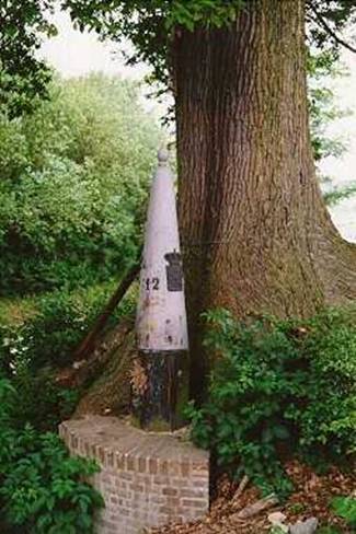
Southernmost point.
|
|
Zuidelijkste punt. Deze grenspaal, nr. 12 op de Belgisch/Nederlandse grens in de provincie Limburg staat op het zuidelijkste punt van Nederland. Het is vlakbij Kuttingen (NL) en Sippenaeken (B). De boom is Nederlands. Het gemetselde muurtje is om te voorkomen dat de paal van de steile helling valt. |
|
|
|
Westernmost
point. |
|
Westelijkste punt. De foto toont grenspaal 360 op de Belgisch/Nederlandse grens bij Sint Anna ter Muiden in de provincie Zeeland. Dit is het meeste westelijkste punt op het land. Het officiële punt ligt in de Noordzee. Rechts op de foto is Nederland. Het restaurant “Hof ter Mude” wordt niet door de grens doorsneden. |
|
|
|
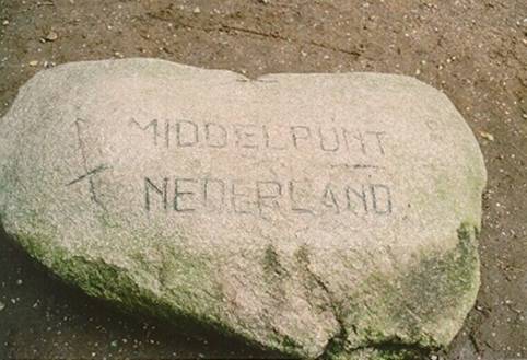
The centre
of The Netherlands.
|
|
Het middelpunt van Nederland. Er zijn verschillende manieren om het middelpunt te bepalen. In Lunteren claimt men het middelpunt te hebben. Mijn GPS gegevens staan genoemd. |
|
|
|
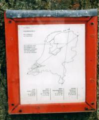
An
other centre of the Netherlands was presented by the art-collective Dier
in Bedrijf. They connected the westernmost and the easternmost points and
the northernmost and southernmost points. On the crossing is the centre near
Oosteinde in the province of Drenthe. |
|
Een ander middelpunt van Nederland werd gepresenteerd door Dier in Bedrijf, een kunstenaarscollectief. Zij verbonden het westelijkste met het oostelijkste en het noordelijkste met het zuidelijkste punt. Op het kruispunt ligt het middelpunt bij Oosteinde in de provincie Drenthe. |
|
|
|
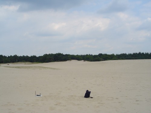
In an article in
NRC-Newspaper of |
|
In een artikel in NRC van 11-07-2003, introduceerde George Beekman een ander middelpunt van Nederland. Neem gewoon halverwege de westelijke en oostelijke lengtegraad en halverwege de noordelijke en zuidelijke breedtegraad en je eindigt hier, in de Lange Duinen bij Soest in de provincie Utrecht. Hier plantte ik een stok. Mijn GPS gegevens staan genoemd |
|
|
|
Centre
of gravity. |
|
Dit is het zwaartepunt van Nederland. In Putten in de provincie Gelderland is dit punt, dat is opgericht op 15-09-1984 en berekend door Frank Storbeck. Als je Nederland aan de ring optilt blijft het land in balans. |
|
|
|
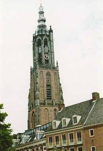
The Onze Lieve Vrouwe Tower in Amersfoort in de province of Utrecht is the original
cadastral centre of the Netherlands for the trigonometry.
|
|
De Onze Lieve Vrouwe toren in Amersfoort in de provincie Utrecht is het oorspronkelijke nulpunt voor de Rijksdriehoeksmeting. Om rekentechnische redenen is dit middelpunt verplaatst van Amersfoort naar een punt ten Z.O. van Parijs, nabij Joigny - Cézy. In de toren geeft een laserstraal het nulpunt aan. |
|


If you
have any information, questions etc. , please contact
me.
Heb je meer
informatie, vragen enz., neem dan s.v.p. contact op.
|
Top |
2023-10-17