Nature provides clues that can help one realize that threatening weather is approaching and that action needs to be taken. Understanding these clues can be the difference in getting to safety in time when weather suddenly turns for the worst.
Thunderstorms occur in all 50 states. They can occur, at any time, day or night, throughout the entire year. Thunderstorms are most common in the late afternoon and evening during the warm months. Approximately 1800 thunderstorms are in progress at any given moment around the world and lightning strikes the earth 100 times every second. Thunderstorms are basically beneficial providing necessary rainfall. In the United States, only about five percent of thunderstorms become severe and only about one percent of thunderstorms produce tornadoes.
What makes a typical thunderstorm:
Thunderstorms range between 5 and 25 miles in diameter making it a very localized storm. There are three essential ingredients necessary to grow a thunderstorm:
1) Moisture - Moisture is necessary to form the cloud and rain.
2) Instability - Warm air is less dense (lighter) than cold air. The sun warms the ground and the ground warms the air above it. Evaporation of moisture from the ground or bodies of water increase the humidity. The warming of the air and the increase in humidity cause the air mass to destabilize. If there is cooler, drier air above, the tendency would be for the air to want to overturn with the cooler air sinking and the warmer air rising. This is instability.
3) Lift - This is the trigger that starts air rising and focuses storms. Examples of Lift -- 1) air moving up a mountain; or 2) air colliding with a front. A front is a boundary between two different air masses. Where the air masses collide, the less dense air (warmer or more humid) will rise over the other. 3) Cool air blowing from an ocean or lake can form a sea-breeze front as it collides with the warmer air inland. 4) The cool outflow from a thunderstorm forms a "gust front" which may in turn cause the development of a new thunderstorms. These are all sources of lift. If instability and moisture is the fuel, than lift is the spark that ignites the storm.
The thunderstorm life cycle:
1) Towering cumulus stage - Imagine a parcel of air like a balloon. If the air in the balloon is warmer than the environment around it, it will rise. As the balloon (air parcel) rises, the air cools, eventually cooling to its condensation point. A cloud becomes visible. As the air condenses, heat is released which helps the air parcel remain warmer than its surrounding environment, and so, it continues to rise, building up speed. This rising air forms the updraft, a thermal. A towering cumulus cloud has grown with crisp, hard edges forming a puffy or cauliflower look to the cloud. The height of the cloud is usually equal to or greater than the width of the cloud's base.
2) Mature thunderstorm stage - The warm air continues to rise until eventually it has cooled to that of its surrounding environment. This is often not until it hits the tropopause and the more stable air of the stratosphere. The storm may now have reached a height of 5 to 10 miles above the ground. The rising air has been moving at speeds near 40 mph. Now as it slows, the upper level winds begin to fan out the cloud forming the anvil. With strong winds aloft and longer lasting storms, anvils can spread 100 miles downwind.
A thunderstorm's updraft can carry 8000 tons of water aloft per minute! The water vapor condenses to cloud droplets which collide and grow in the rising updraft. Eventually, the weight of the droplet overcomes the rising air and it falls. The falling rain droplets begin to drag the air down around them and a downdraft forms. The rain also is falling into unsaturated air and so some evaporation occurs. Evaporation is a cooling process (your body cools when sweat evaporates from your skin). This rain-cooled air is now cooler than its surrounding environment and it sinks, helping to form and intensify the downdraft. A thunderstorm with concurrent updrafts and downdrafts is considered mature. As little as 20 minutes has elapsed since the cloud began to form.
3) Dissipating stage - As the downdraft hits the ground, the rain-cooled air begins to spread out in all directions. Eventually, this more stable air (since it is cool) chokes off the warm inflow that was driving the storm's updraft. With no new fuel to keep the storm alive, it dies. The downdraft dominates and the storm rains itself out. Sometimes, all that is left it the anvil.
This entire thunderstorm life cycle from the growing cumulus cloud to the dissipated storm can take only 30 minutes. This is why thunderstorms can strike so quickly and with little if any warning. The National Weather Service predicts the likelihood of thunderstorms to develop, but does not warn for lightning nor general thunderstorms.
What causes thunder?
A lightning stroke carries an electrical potential of 100 million volts. This tremendous release of energy is converted to heat. Air around the lightning channel explosively expands as it is heated to nearly 50,000�F! After the discharge, the air rapidly cools and contracts. This sudden expansion and contraction of air molecules produces the sound wave which we identify as "thunder." Because the speed of light is a million times faster than that of sound, we see a lightning stroke before we hear it.
You can estimate the distance (in miles) to a lightning stroke by counting the number of seconds between seeing the lightning and hearing the thunder, then divide by five. Just remember that lightning can come from the anvil portion of the thunderstorm and strike the ground 10 to 15 miles from the rain portion of the storm. So, just because you are estimating lightning at a distance of 2 or 4 miles away, doesn't mean that the next strike won't be right next to you!
Understanding the Dangers of Lightning:
If you are outside and there are thunderstorms within 10 miles, you are at isk of being struck. In rare cases, lightning has been known to travel as far as 15 miles from the storm. There are four different types of lightning: 1) within cloud, cloud-to-cloud, cloud-to-air, and cloud-to-ground. Lightning can occur from any portion of the thunderstorm cloud. Thunderstorms can extend up to 10 miles high in the atmosphere and they are often tilted by stronger winds aloft. High clouds above you may be part of a thunderstorms anvil. Often during the dissippating stage of a thunderstorm, lightning will strike from the upper reaches of the storm including the anvil.
A study on lightning conducted in Florida found that the average distance between one lightning strike hitting the ground and the next was two to three miles. That means that (using the technique described in the section on thunder above) you may have just seen a lightning stroke in the distance and it took a full 15 secods before the thunder reached you. It seemed a long way away and yet, on average, the next strike could be right next to you.
The most common mistake made by people is to let an outdoor activity continue because it appears as though a thunderstorm is too far away to be a danger. Many people think that if it is not raining, then they are okay, yet it is not the rain that can kill them. People who have been struck by lightning have noted that they heard some distant thunder, but there was blue sky overhead and so they perceived no threat.
The rule is simple: If you can see or hear thunder, take action immediately. The activity can be resumed when it appears as though the storms have passed and lightning has not been seen nor thunder heard for at least 15 minutes.
Shelter: Every one needs to move inside a building or a car. In buildings, do not remain standing in the door way and close windows and doors. Do not use telephones and computers. In a car, truck, or bus, windows and doors need to be closed. Convertibles, even with the tops up, are not protected. If an activity is postponed to let the storm pass, try not to allow spectators to linger in unprotected areas. At a Lacrosse game in the District of Columbia, the game was called as a thunderstorm squall line rolled into the city. The teams went inside to the locker rooms to wait out storm. A group of spectators who had been watching the game, took cover under a tree. The tree was struck. A 16 year old boy was killed and 10 others were injured.
Lightning will be attracted to the tallest object. Tall trees are a prime example. Sports fields are a high risk area. The tallest object may be the players, or goal posts. Lightning may strike both players and goal posts at once. Metal bleachers, tall lights for night-time play, and metal fences around ballfields are all at risk of being struck. Even the dugout are not safe.
Thunderstorm Clues:
The more unstable the air mass and the stronger the lifting mechanism, the stronger the thunderstorm updraft becomes and the more likely the storm will be severe. Increasing winds with height also help to the storms ability to maintain itself. The longer a storm lasts, the greater chance it has of becoming severe. The National Weather Service defines a severe thunderstorms as a storm producing three-quarter inch or larger hail and/or winds greater than 58 mph. When thunderstorm updrafts reach speeds of 70 mph, they can support the growth of hailstones.
A hailstone is a lump of ice that falls from a thunderstorm. It can range from pea size to the size of grapefruit. Such large hail can impact the ground at nearly 100 mph demolishing crops, breaking windows, and damaging roofs, cars and airplanes. Hail begins as rain droplets which are carried by strong updrafts to high altitudes (well above the freezing level) where they are rozen into ice pellets. The ice pellets collide with more water droplets which freeze to the surface of the developing hail stone increasing its size. The stone continues to grow until the updraft can no longer suspend its weight and the hail falls to the ground.
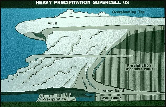
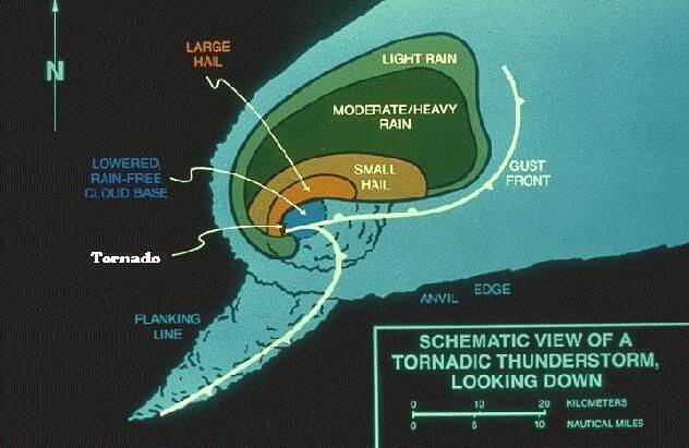
Long-lasting thunderstorms, sometimes referred to as supercells, are more likely to be severe. For a thunderstorm to last, it must be able to sustain both its updraft and its downdraft. One way that this occurs is with increasing winds with height. If the horizontal wind, blowing into the storm, is stronger in the mid and upper reaches of the storm, the rising updraft becomes tilted. Now the rain is carried downwind of the updraft instead of collapsing upon it. Another important factor is if the horizontal wind, blowing into the storm, veers with height (changes direction in a clockwise motion), the storm's updraft may begin to rotate. The combination of veering and increasing winds with height can produce a tilted and rotating updraft. This rotating thunderstorm, called a mesocyclone, is able to maintain its updraft and warm inflow region independent of the stormsrain-cooled outflow. The rotating updraft of this type of thunderstorm is where the tornado can form and descend to the ground.
The Downburst: So far, we have discussed how strong updrafts can produce hail and rotating updrafts can produce tornadoes, but what about downbursts or damaging straight-line winds from thunderstorms? A downburst is a powerful, concentrated downward burst of air, that occurs in the downdraft region of the thunderstorm. Looking at the map view of a severe thunderstorm above, it tends to occur in the moderate to heavy rain region of the storm. One theory for how downbursts originate is that a layer of drier air, between perhaps 10 and 20 thousand feet high, is entrained into the thunderstorm. As rain falls through this drier air, it evaporates, rapidly cooling the air. This cold ball of air, now denser than its surrounding environment, descends toward the ground. The momentum of the winds in this mid-level dry layer (the wind blowing into the storm) is now tilted downward and is accelerated by gravity. The burst of rain-cooled air smacks the ground and spreads outward. Wind speeds produced by downbursts can reach over 100 mph and produce damage similar to a tornado. However, downbursts damage paths are usually broader than tornado paths.
The term straight-line wind when referring to a thunderstorm wind is the rain-cooled air of the downdraft as it spreads out and away from the thunderstorm. The wind is moving in a straight-line as opposed to rotating like a tornado. Therefore, straight-line damaging winds from a thunderstorm is generally caused by a downburst. In aviation, the term wind shear is used. Wind shear is the change of wind speed and direction. A downburst is extremely dangerous to aircraft on takeoff and landings because of the strong wind shear. Wind speed and direction is in constant flux and the pilot can not compensate fast enough. A microburst refers to a small downburst (less than 2 miles across). A downburst larger than that would be called a macroburst.
Your local National Weather Service Office provides severe weather spotter training under a program called SKYWARN. It is provided free of charge with the request that when you do encounter severe weather, you report it to the National Weather Service. The spotter training class includes 100 slides that help you learn how to pick out visual clues from clouds to help determine the severity of a storm. It is highly recommended that at the least one person from your school, preferably the "Severe Weather Coordinator" for your school emergency plan, take the training. The following information is not a substitute for official training.
Color: A very dark (black) thunderstorm or one taking an eerie look (brownish, green, or yellow cloud colors) may be an indication of a severe thunderstorm. The colors and darkness of the cloud are caused by the storm's massive size and the blockage of sunlight. This storm may bring hail, very heavy rain, and damaging winds. Take protective action immediately.
Sound: The sound of a freight train is the roar of wind as it moves through trees and buildings. It may indicate an approaching tornado or severe downburst. The rapid rotation of winds in a tornado also sometimes make a high pitch whistling or whirling noise. In any of these cases, you should take protective action immediately.
Swirling Debris: Tornadoes are sometimes obscured by rain, low clouds, trees, or buildings that block your view of the funnel. A visible funnel need not even be touching the ground (it may only extend half or two-thirds of the way from the cloud toward the ground). But even with weak tornadoes, swirling debris or debris rising up in the air can often be seen. This is a sure sign of significant damaging winds and protective action must be immediate.
Shelf Cloud / Roll Cloud: The rain-cooled air flowing out of a thunderstorm forms the gust front. Warm air ahead of the gust 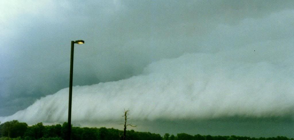 front rises up into the storm forming a wedged-shape cloud called a "shelf cloud" on the leading edge of the storm. The sharper or more defined that this cloud is, the stronger the winds are below. As the cool wind continues to blow out ahead of the storm, the shelf cloud can become detached from the storm forming a "roll cloud". This horizontal cloud is not a tornado. It marks the gust front (the gust front is the leading edge of the rain-cooled outflow from the thunderstorm). If you see a well-defined roll cloud rolling toward you, prepare for strong and possibly damaging winds as it passes.
Mammatus Clouds (also known as Mamma): These clouds hang down from the anvil portion of the thunderstorm. They look like breasts (hence the Latin term) or like a cumulus cloud turned upside down. Mammatus clouds are often an indication that the storm is severe. Prepare for possible hail and damaging winds.
Rotating storms: Sometimes it is possible to see the entire thunderstorm rotating. Generally, to see this you are located south of the storm or behind it. The storm is usually then moving away from you. A rotating thunderstorm is likely severe and may produce a tornado. If the storm is, by chance, moving toward you, prepare for severe winds and hail. Otherwise, report your sighting to the National Weather Service.
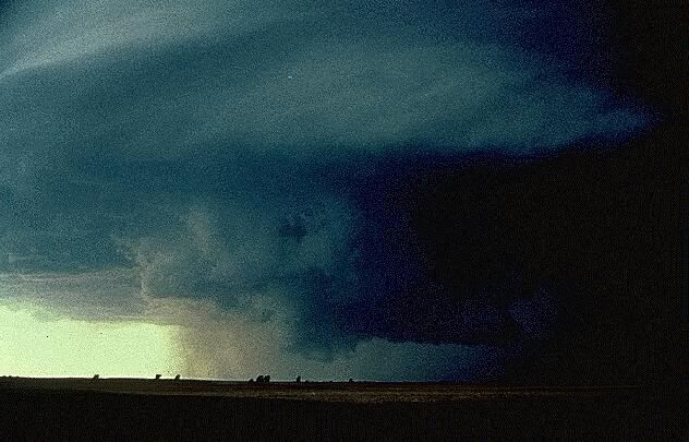 Rotating Wall Cloud: This is a lowering of clouds from the rain-free cloud base (updraft region) of the storm. It is circular in shape and can be seen slowly rotating. Sometimes a tail forms from the wall cloud toward the rain area of the storm Air is moving in and rising up into this portion of the cloud. This is a sign of a tornadic thunderstorm. If a tornado is to form it will generally descend from the storm near or within the wall cloud. Take cover immediately if this is approaching you. Otherwise, contact the National Weather Service with your sighting.
Funnel / Tornado: A funnel is a small rotating funnel-shaped cloud. It does not touch the ground. If the funnel-shaped cloud is touching the ground, it is a tornado. Only about 50 percent of funnels turn into tornadoes. It is possible for the rotating column of damaging winds from a tornado to be on the ground with the visible funnel only extending half-way to the ground. Look for debris, leafs and dust rising into the air and listen for the sound of a freight train.
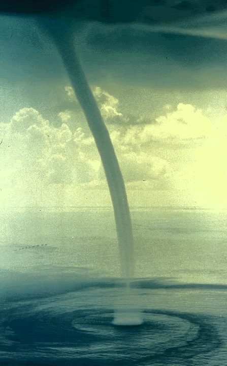
Waterspouts: When a tornado moves over water, it is called a waterspout. Waterspouts can also occur in more benign situations and these are not severe but still may have winds of 35 to 50 mph.
Squall lines: Sometimes thunderstorms form a solid line of storms called a "squall line". The squall line thunderstorm can also become severe and is unlike the supercell thunderstorm discussed earlier (see diagram showing side and map views of a typical severe thunderstorm under section B). The supercell storm has its updraft on the right-rear quadrant of the storm. With a squall line, the warm air feeding the storm is all out ahead of it, so the updraft on the front (approaching) portion of the storm dominates.
When a squall line approaches, you will see the shelf cloud which is the leading edge of the storm (see discussion on shelf clouds). Tornadoes rarely occur with squall lines and they tend to be less severe than those with supercell storms. Still, winds can reach 100 mph which is enough to damage roofs, break windows and drop trees. The tornado in this case will precede the rain. The tornado would be found in the updraft region of the storm behind the shelf cloud.
Page Last Updated, 05/08/09