
JASON'S STORM CHASING WORLD
\chaser\chasedays\020102.html
| JANUARY 2ND, 2002 |
Pictures are on top, with the log just below. Mesoscale discussions,
Watches and Warnings, as well as
a Preliminary Damage Report are located at the very bottom.
At around 3:30pm EST - Looking dead south  |
3:30pm EST - Looking southeast  |
Bayfront Park, east of Homestead at 3:55pm EST Looking east into Biscayne Bay  |
| Bayfront Park, east of Homestead at 3:55pm EST Looking east-southeast into Biscayne Bay  |
Bayfront Park, east of Homestead at 3:55pm EST Looking east-southeast into Biscayne Bay  |
Bayfront Park, east of Homestead at 3:55pm EST Looking east-southeast  |
| Canal Drive (SW 328th St.) near SW 110th Ave. Looking west with tree damage in foreground  |
Canal Drive (SW 328th St.) near SW 110th Ave. Looking west with tree damage in foreground  |
Canal Drive (SW 328th St.) near SW 110th Ave. Tree where branches broke off.  |
| Canal Drive (SW 328th St.) near SW 110th Ave. Not the biggest brance of this tree!  |
On SW 117th Ave, north of 336th St. Looking south [approx. 4:45pm EST]  |
On SW 117th Ave, north of 336th St. Looking south [approx. 4:47pm EST]  |
| On SW 117th Ave, south of 336th St. Looking south [approx. 4:45pm EST]  |
SW 344th St. southside of Homestead Speedway Looking south [approx. 5:15pm EST]  |
SW 344th St. southside of Homestead Speedway Looking south [approx. 5:15pm EST]  |
| SW 344th St. southside of Homestead Speedway Looking north (at the Racetrack) [5:15pm EST]  |
SW 344th St. southside of Homestead Speedway Looking southwest [approx. 5:15pm EST] 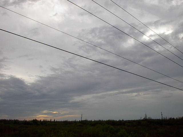 |
SW 344th St. southside of Homestead Speedway Looking southeast [approx. 5:15pm EST]  |
| SW 344th St. near US-1 (just beyond pam trees) Looking east-northeast [approx. 5:15pm EST]  |
Card Sound Road (where NWS reported damage). Looking north-northeast [5:30pm EST]  |
Card Sound Road (where NWS reported damage). Looking north-northeast [5:30pm EST]  |
| Card Sound Road (where NWS reported damage). Looking west [5:30pm EST] No tornado signs  |
Card Sound Rd. (where NWS reported damage) Looking Northeast, pole not broken [5:30pm EST]  |
204 Flager Rd, Homestead (NWS damage report) AAA Lumber company, had some damage.  |
| 204 Flager Rd, Homestead, pole damage, appears transfer fell off to ground. 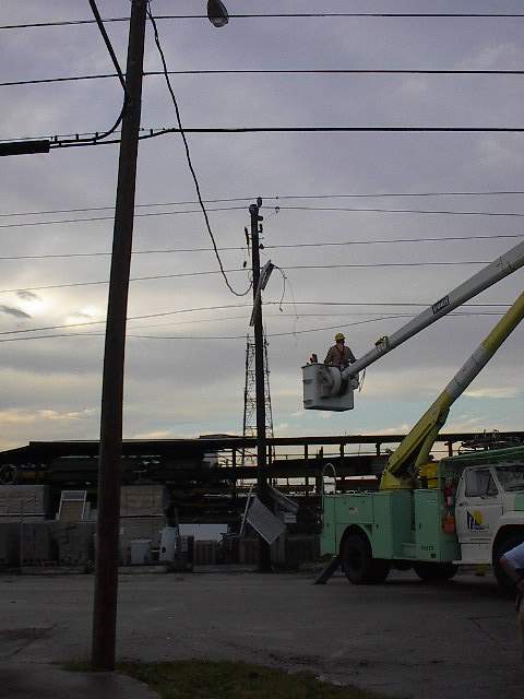 |
204 Flager Rd, Homestead; bldg. sheet metal wrap- ped around pole, typical tornadic signature. 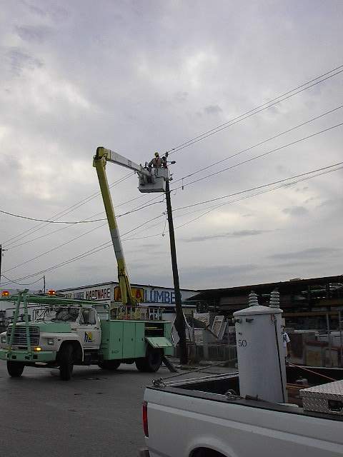 |
204 Flager, Homestead; more shots of damage to lumber yard stockpiles.  |
| 204 Flager Rd., Homestead; directly across the street looking southeasterly [5:45pm EST]  |
204 Flager Rd., Homestead; last picture taken that day.  |
Note: If this is confirmed to be a tornado, then that will mark the first tornado of 2002. Something to ponder (for no particular reason). Maybe a good sign for my upcoming storm chasing expeditions. |
| It's January 2nd, 2002, just into the New Year. And already
we have the first tornado. I did get a chance to chase, but did not sight
the actual tornado (NWS still to confirm if one was actually there). If so,
I guess I get the privilege of starting of the year for storm chasers.
2:45pm This chase began with myself at home, rummaging through papers, getting my filing done. My niece had a friend over, and mentioned about possible tornado watches. (I think she used the term "look out"). The skies outside were darkening, and a distance rumble of thunder could be heard. I'm new to Florida, so I figured "awh, just another typical thunderstorm!" But, I did have my internet connection going, and decided to check email, to see if my good friend Jeff Gammons (of Weathervine) had sent anything out. Sure enough, he and many others were sending out the NWS watches and warning on the newsgroups and email reflectors. The latest email was from another good friend, Ray Vaughan, who sent out the Tornado Warning text from NWS, which I read at lightning speed, and before I was finished, I was looking for my Skywarn T-Shirt, Storm Chaser hat (which I never found), and had my hand on my [almost] always ready-to-go camera bag. 2:55pm I grabbed the keys and was out the door. I threw the bag in the car, started up the GPS, remembered I forgot the tri-pod (so I went back in), locked the door, and jumped in to start the truck. Rrruurrrurrrurrrrurrr. Rrrruuuruuuruuuruu. "Damn it, not NOW!" Rrrruuurrruuurruurrr. OK, I've had this before. My 1999 has so many electronic [junk] stuff in it, something keeps it from starting. I have to unplug half the electronics in the engine before I figure out which sensor, or whatever it is, allows my truck to start. 3:05pm After 10 minutes, and a now rainy wet, frustrated Jason is in the truck, heading to US-1 to head south toward the anticipated path. I had the local 2 meter ham radio band repeater (147.000 SFFMA repeater out of Homestead) on and the WX4MIA Skywarn Net was running out of the Miami NWS office. Because of the Warning, traffic was kept to a minimum. I pried a bit of info out of the Net Control, to better assess my best approach angle. 3:15pm The roads are sufficiently wet, so traffic of course is coming to a crawl on US-1, to it's left onto SW220th St. and the right onto a parallel street. I make a few more turns which basically get me to a good, clear road to head south (I live here less than 6 months, and I know the roads better than ¾ of the locals, without trying). 3:20pm Up ahead (looking south) I can see very dark clouds, and to the east, it's clear, but not by much. I see the edge of the storm, but there's no classical structure, so with the combined assessment of the visual on the clouds, and the reports coming out of NWS, I'm going in the right direction, due south. I'm also thinking I need to stay east of the storm, so I can be in the clearing, but there really isn't enough time, and the eastern edge near the coast has terrible road networking for chasing. 3:30pm Ok, I'm basically due east of upper Homestead and the rain is extremely heavy, in excess of 1.5" to 2" per hour rate. Lightning is often, close, and extremely bright (dah, I know). Because of the heavy rainfall an steadily increasing heavy winds, I can't hear the lightning all that much. I'm in the farm areas were everything is very flat, exposed, and vegetation is light. In this part of Florida, irrigation canals are everywhere. Roadways are especially dangerous since there's no shoulder and the canals are only 4 or five inches from the roadside, on both sides. Hydroplaning is common here, with little place for the water to run of to. I'm very cautious driving at this point. I don't like the fact I don't have a place to go if a strong wind comes along and pushes the truck right into the canal. 3:45pm Perfect timing, the roads improve in this one area, so I pull in, just as a large gust, likely around 50mph or more, rushes across the truck. I jump out to try to take a picture with the 35mm SLR, with little success. I can feel the dirt from the fields pelting me. I can see the rain is nearly completely horizontal, and ahead the view into the [baby] palm tree field is not helping to calm my "core" fears. I'm looking all around for a place to bail into if something major appears, but I'm also looking to see if there's a photo opportunity too. 3:50pm Skywarn net is saying the 'Doppler Indicated' tornado has moved offshore into Biscayne Bay, and is nearing Elliot Key getting ready to move into the Atlantic. I'm not far from the coast so I decide to try to see if I can see anything from there. 3:55pm I'm not at Bayfront Park east of Homestead, where I see nothing but gray skies, with the ever so slight hint of some structure, but not even the camera can pick-up any detail. 4:05pm I'm driving around, taking pictures of the little areas of damage I see, and NWS on the ham radio starts broadcasting some of the areas were damage reports are coming in. I attempt to map them, seeing that there's little chance for further active chasing at this point. I'm in 'Damage Assessment Mode'. I drive all over Southwestern areas of Homestead, and the farm areas of Southwest Dade County. I travel by the Homestead Raceway, and then to Card Sound Road, for some damage there. Then I'm up to the center of Town of Homestead, where the heaviest damage is reported. I find some, but not all, but with fading light I know I'm about to loose any chance of photo taking. 5:30pm After driving around Homestead (lost for the most part), I think about heading into the Keys for a possible southern Storm, that if it comes close enough, would give me some lightning photo opportunities. 6:30pm I arrive at the spot were I met Jeff and Dave from Weathervine when we tried to get some shots out of Hurricane Michelle. The spot is in Islamorada, in the Florida keys, not to far south of Key Largo. I stayed there, checked into the Red Cross Net at 7pm, and with no sign of incoming storms from the south, I start heading home. That pretty much concludes this chase log. The only tasks left are to keep an eye on the news, and quick keyboard on the web sites, for possible additional information and reports on this days storms. I also have to build and complete the Web page on my own site for this chase day. |
SPC MESOSCALE DISCUSSION 0001 FOR SRN FL AND THE FL KEYS
CONCERNING...SEVERE THUNDERSTORM POTENTIAL...

VALID 021442Z - 021700Z

A POTENTIAL THREAT FOR ISOLATED TORNADOES AND/OR WIND DAMAGE
IS EXPECTED OVER SRN FL INCLUDING THE FL KEYS /SOUTH OF A LINE FROM
FMY-PBI/.  WE WILL CONTINUE TO MONITOR THIS REGION AND AN UPGRADE
TO A SLIGHT RISK WILL LIKELY BE REQUIRED IN THE NEXT UPDATE AT
1630Z.

SURFACE ANALYSIS SHOWS A SURFACE LOW OVER THE ERN GULF OF MEXICO
WITH A TROUGH EXTENDING SEWD THROUGH EXTREME SRN FL.  SURFACE
DEWPOINTS ARE IN THE UPPER 60 F SOUTH OF THIS TROUGH...WITH ESELY
WINDS OVER THE KEYS INTO SRN FL.  SURFACE WINDS ARE EXPECTED TO
VEER TO THE SOUTH LATER THIS MORNING AS THE SURFACE LOW APPROACHES
CENTRAL FL...ADVECTING THE HIGHER DEWPOINT AIR NWD INTO SRN FL.
SUFFICIENT DEEP LAYER SHEAR EXISTS OVER SRN FL INTO THE KEYS TO
SUSTAIN UPDRAFT STRENGTH OF STORMS MOVING ONSHORE FROM THE GULF.
THE LACK OF STRONG INSTABILITY WILL RESULT IN ISOLATED
TORNADOES/STRONG WINDS BEING THE MAIN THREATS.

..PETERS.. 01/02/02
BULLETIN - EAS ACTIVATION REQUESTED
TORNADO WARNING
NATIONAL WEATHER SERVICE MIAMI FL
230 PM EST WED JAN 2 2002

THE NATIONAL WEATHER SERVICE IN MIAMI HAS ISSUED A

* TORNADO WARNING FOR...
WESTERN MIAMI-DADE COUNTY IN SOUTHEAST FLORIDA
MAINLAND MONROE COUNTY IN SOUTHWEST FLORIDA

* UNTIL 300 PM EST

* AT 230 PM EST... NATIONAL WEATHER SERVICE DOPPLER RADAR INDICATED A
DEVELOPING TORNADO 12 MILES WEST OF MAHOGANY HAMMOCK...MOVING EAST
AT 25 MPH.

* SOME LOCATIONS NEAR THE PATH OF THE STORM THROUGH 300 PM EST...
MAHOGANY HAMMOCK
ROYAL PALM RANGER STATION

FREQUENT LIGHTNING IS OCCURRING WITH THE PARENT STORM. IF OUTDOORS...
STAY AWAY FROM ISOLATED HIGH OBJECTS SUCH AS TREES AND AVOID WATER.
MOVE INDOORS OR INSIDE A VEHICLE IF POSSIBLE. WHEN INDOORS...STAY
AWAY FROM WINDOWS AND DOORS AND AVOID USING TELEPHONES UNLESS IT IS
AN EMERGENCY. TRY TO UNPLUG UNNECESSARY ELECTRICAL APPLIANCES BEFORE
THE THUNDERSTORM APPROACHES.

REPORT SEVERE WEATHER OR DAMAGE TO THE NEAREST LAW ENFORCEMENT AGENCY
OR YOUR COUNTY EMERGENCY MANAGEMENT. THEY WILL RELAY YOUR REPORT TO
THE NATIONAL WEATHER SERVICE FORECAST OFFICE IN MIAMI. OR YOU CAN
ALSO CALL THE NATIONAL WEATHER SERVICE IN MIAMI DIRECTLY AT 305 229
4522 TO REPORT SEVERE WEATHER.

LAT...LON 2538 8113 2520 8108 2529 8054 2556 8063

.END

PIFER
Notice the locations in the path have been increased.

BULLETIN - EAS ACTIVATION REQUESTED
TORNADO WARNING
NATIONAL WEATHER SERVICE MIAMI FL
257 PM EST WED JAN 2 2002

THE NATIONAL WEATHER SERVICE IN MIAMI HAS ISSUED A

* TORNADO WARNING FOR...
SOUTHERN MIAMI-DADE COUNTY IN SOUTHEAST FLORIDA

* UNTIL 345 PM EST

* AT 257 PM EST... NATIONAL WEATHER SERVICE DOPPLER RADAR INDICATED A
DEVELOPING TORNADO NEAR MAHOGANY HAMMOCK...MOVING NORTHEAST AT 35
MPH.

* SOME LOCATIONS NEAR THE PATH OF THE STORM THROUGH 345 PM EST...
MAHOGANY HAMMOCK
ROYAL PALM RANGER STATION
FLORIDA CITY AND REDLAND
HOMESTEAD
NARANJA
PRINCETON AND GOULDS

FREQUENT LIGHTNING IS OCCURRING WITH THE PARENT STORM. IF OUTDOORS...
STAY AWAY FROM ISOLATED HIGH OBJECTS SUCH AS TREES AND AVOID WATER.
MOVE INDOORS OR INSIDE A VEHICLE IF POSSIBLE. WHEN INDOORS...STAY
AWAY FROM WINDOWS AND DOORS AND AVOID USING TELEPHONES UNLESS IT IS
AN EMERGENCY. TRY TO UNPLUG UNNECESSARY ELECTRICAL APPLIANCES BEFORE
THE THUNDERSTORM APPROACHES.

THIS IS A DANGEROUS STORM. IF YOU ARE IN ITS PATH YOU SHOULD PREPARE
FOR DAMAGING WIND IN EXCESS OF 60 MPH...LARGE HAIL...AND DEADLY
LIGHTNING. PEOPLE OUTSIDE SHOULD MOVE TO A SHELTER...PREFERABLY
INSIDE A STRONG BUILDING BUT AWAY FROM WINDOWS.

LAT...LON 2540 8090 2523 8082 2545 8018 2568 8029

.END

PIFER

WWWW
SPC MESOSCALE DISCUSSION 0003 FOR SE FL AND KEYS
CONCERNING...SEVERE THUNDERSTORM POTENTIAL...

VALID 021815Z - 022200Z

CONVECTIVE WIND AND TORNADO POTENTIAL WILL INCREASE OVER MAINLAND
MONROE COUNTY AND LOWER KEYS BY 20Z...THEREAFTER...MIDDLE-UPPER
KEYS AND BULK OF MIAMI-DADE COUNTY.  THREAT AREA IS RATHER SMALL
SPATIALLY...BUT NONETHELESS BEING MONITORED FOR POSSIBLE WW.

AIR MASS ACROSS MAINLAND MONROE/DADE COUNTIES CONTINUES TO
DESTABILIZE WITH MOIST ADVECTION AND SOME INSOLATION...WITH TEMPS
MID-UPPER 70S F AND DEW POINTS LOW 70S EXPECTED.  MODIFIED RAOBS
YIELD MLCAPE 700-1000 J/KG.  BROKEN BUT INCREASINGLY WELL ORGANIZED
LINE OF TSTMS -- EXTENDING AT 18Z FROM ABOUT 25 SSW CHOKOLOSKEE
ISLAND TO 30 SSW DRY TORTUGAS AND BEYOND -- SHOULD REMAIN WELL
ORGANIZED AS IT MOVES E...AMIDST VERTICAL SHEAR PROFILES SUPPORTING
BOTH BOWS AND EMBEDDED SUPERCELLS.  STRONGLY BACKED SURFACE FLOW
NOW EVIDENT OVER UPPER KEYS/MIAMI-DADE COUNTY LAND SITES AND C-MANS
MAY VEER SLIGHTLY TOWARD SSE OR S AS CONVECTION APPROACHES...BUT
STILL MAINTAINING 150-300 J/KG SRH BASED ON FORECAST HODOGRAPHS.
THOUGH DEEP-LAYER SHEAR WILL REMAIN INTENSE BENEATH 100-120 KT
ANVIL LEVEL JET...WEAKNESSES IN BOTH CAPPING AND MID LEVEL SR FLOW
SUGGEST CONTINUED LINEAR MODE OVERALL WITH SOME DISCRETE/RAIN-
WRAPPED MESOCYCLONES AND SMALL BOWS.

..EDWARDS.. 01/02/02
PRELIMINARY LOCAL STORM REPORT
NATIONAL WEATHER SERVICE MIAMI, FL
429 PM EST WED JAN 2 2002

TIME(EST)  .....CITY LOCATION.....STATE   ...EVENT/REMARKS...
           ....COUNTY LOCATION....

0330 PM    REDLAND                   FL   .25 INCH HAIL
01/02/02   MIAMI-DADE                     REPORTED BY
SPOTTERS

0330 PM    REDLAND                   FL   50 MPH TSTM WIND GUST
01/02/02   MIAMI-DADE

0335 PM    HOMESTEAD                 FL   .25 INCH HAIL
01/02/02   MIAMI-DADE                     REPORTED BY HOMESTEAD AIR
                                          BASE EMPLOYEE

0340 PM    HOMESTEAD                 FL   1.00 INCH HAIL
01/02/02   MIAMI-DADE                     QUARTER-SIZED HAIL CRACKED
                                          SIDE WINDOW OF VAN REPORTED
                                          BY PUBLIC

0345 PM    HOMESTEAD                 FL   57 MPH TSTM WIND GUST
01/02/02   MIAMI-DADE                     THUNDERSTORM GUST TO 49
                                          KNOTS REPORTED BY HOMESTEAD
                                          AIR BASE OBSERVER

0345 PM    HOMESTEAD                 FL   TORNADO
01/02/02   MIAMI-DADE                     ROOF DAMAGE TO THREE
                                          BUSINESSES AT 204 NORTH
                                          FLAGLER AVE IN
                                          HOMESTEADREPORTED BY LAW
                                          ENFORCEMENT

0350 PM    5 S HOMESTEAD             FL   TORNADO
01/02/02   MIAMI-DADE                     TREES DOWN AND POWER POLES
                                          LEANING ALONG CARD SOUND
                                          ROAD SOUTH OF HOMESTEAD
                                          REPORTED BY FLORIDA HIGHWAY
                                          PATROL

0350 PM    HOMESTEAD                 FL   TORNADO
01/02/02   MIAMI-DADE                     ROOF/POOL/OTHER PROPERTY
                                          AND TREE DAMAGE AT 449 SW
                                          17TH TERRACE REPORTED BY
                                          PUBLIC

0355 PM    HOMESTEAD                 FL   TORNADO
01/02/02   MIAMI-DADE                     TORNADO SPOTTED BY
                                          HOMESTEAD AIR BASE OBSERVER
                                          2 MILES WEST OF BASE

TW
If you'd like to email me, please mail me at this address:
n3prz@aol.com
Introduction,
Partners,
Checklists, Cost Overview, Chase Logs,
Vehicle List,
Links, Pictures,
Weather,
Home