The following images were captured from the GOES 8 geostationary satellite. Because the GOES satellites are in geosynchronous orbits, they appear to remain in the same place in the sky. Typically a 4-6 foot dish is used to receive these images transmitted on 1691 MHz. Hundreds of GOES images are transmitted each day, many relayed from other satellites displaying images from around the Earth.
To get the full effect of the resolution provided by the GOES weather satellites please view the high resolution versions available for each of the "thumbnail" images below. Return to home page.
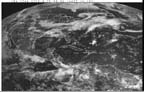
This image was taken in visible light from GOES 8. Click
image for higher resolution (72KB).
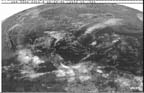 This GOES 8 IR image shows temperature variations. Click
image for higher resolution (62KB).
This GOES 8 IR image shows temperature variations. Click
image for higher resolution (62KB).
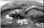 This is called a "water vapor" image and shows where high concentrations
of moisture in the air (white) are located. Click image for
higher resolution (59KB).
This is called a "water vapor" image and shows where high concentrations
of moisture in the air (white) are located. Click image for
higher resolution (59KB).
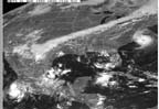 This image is from Meteosat 3, a European weather satellite that
was "loaned" to the US for a time. The hurricane is Emily.
Click image for higher resolution (65KB).
This image is from Meteosat 3, a European weather satellite that
was "loaned" to the US for a time. The hurricane is Emily.
Click image for higher resolution (65KB).