
"Creating computer software is always a demanding and painstaking process -- an exercise in logic, clear expression, and almost fanatical attention to detail. It requires intelligence, dedication, and an enormous amount of hard work. However, a certain amount of unpredictable and often unrepeatable inspiration is what usually makes the difference between adequacy and excellence." (From the Unix "fortune" program.)
While most of the software I create is done for personal use, some is of enough general interest to warrant release to the public.
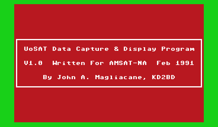
My first commercial software application was The UoSAT Data Capture And Display Program, a telemetry and data capture program written for and donated to AMSAT North America in 1991. This program was designed in the late 1980s as part of a low-cost satellite ground station designed around a Commodore 64 home computer to decode and analyze the "living conditions" on-board the University of Surrey's OSCAR-9 and OSCAR-11 satellites. The program was written entirely in hand assembled machine language (6510 processor), and even decoded DCE (Digital Communication Experiment) information frames transmitted by OSCAR-11. (OSCAR-11's DCE was the precursor to later "Pacsat" satellites that employed digital store-and-forward protocol transponders.)
The following is a small example of data captured from the UoSAT-2/OSCAR-11 spacecraft using this software:
***UOSAT 2 COMPUTER STATUS INFORMATION***

COMMAND DIARY V4.6 IN OPERATION
UNIVERSAL TIME IS 15:18:15
DATE 25/09/87
AUTO MODE IS SELECTED
0A RAM ERRORS AT ACA0H
SPACECRAFT SPIN PERIOD IS -008BH SECONDS
LAST CMD SENT BY COMPUTER WAS 40H TO 1
LAST CMD RECD BY COMPUTER WAS 6DH TO 0 WITH DATA 00H

CURRENT WOD COMMENCED AT 00:00:00
DATE 25/09/87
SURVEY INCLUDES CHANS 01,02,03,61,

****  UoSAT-OSCAR-11    BULLETIN - 105   24 September 1987  ****

                  UoSAT MISSION CONTROL CENTRE,
        University of Surrey, Guildford, Surrey, England

** UOSAT TEAM **

Reports, letters, queries and requests from the UoSAT
experimenter community arrive at UoS and you might be interested
to know who it is that you are 'talking' to! All the incoming
mail is first read by G3YJO, then coded and passed to the most
appropriate member of the UoSAT team to deal with in detail.
Requests for standard information sheets, booklets, slides etc.
are handled by Jackie Brooks, whilst technical queries by UoSAT
engineers who either reply by mail or via the Bulletin (when the
answer may be of general interest). The UoSAT team comprises:


Dr Martin Sweeting   G3YJO      Director, RF systems, telecommand
Dr Lui Mansi                    On-board data handling, telemetry
Stephen Hodgart                 Attitude Control, signal processing
Steve Holder                    On-board Computer software
Michael Meerman      G0/PA3BHF  Spacecraft Operations, CCD
Jacky Radbone        G8WJN      CCD, Particle-Wave, mission studies
Jeff Ward            G0/K8KA    DCE
Lionel Watkins                  Modulation schemes
Paul Wright                     Attitude Control
Hok Wong                        Spacecraft Power systems
Craig Underwood      G1GTW      Sats In Ed, Groundstation s/ware
Dinesh Patel                    Orbit studies
Mike Blewett         G4VRN      Spacecraft Power systems
Richard Clarke       G8UNO      Telemetry subsystems
Bob Doran            G4VRC      Mechanics, data collection
Martin Day                      Engineering
'Mac' Macbeth        G8VLY      Engineering
Brian Crosse                    Technician
Martin Nunn          G6FNK      Technician
Tim Setterfield                 Technician
Chris Payne          G8VRL      On-Board Data Handling Research Student
Hamid Mahde          G1XWI      On-Board Data Handling Research Student
Robert Edgell                   Space Radiation Effects Research Student
Jackie Brooks                   Secretary/PA/Administration


**UoSAT SPACECRAFT **

Several stations have enquired why the UO-9 VHF downlink appears
to be 'stronger' than UO-11 on similar passes.   Firstly, the
UO-11 transmitter yields between 220 mW (eclipse) and 480 mW
(sunlit) RF output dependent on battery voltage (the power taken
by the VHF tx decreases as battery voltage decreases
deliberately to avoid excessive discharge). UO-9 generally
yields around 475 mW and is rarely in eclipse at present.
Secondly, UO-11 is at 698 km and UO-9 at 478 km thus, when
overhead, UO-9 is some 3.2 dB 'closer'! Consequently, but also
dependent on the groundstation antennas used, UO-9 can be up to
6 dB stronger than UO-11 under certain circumstances.

* UO-11 Operations *

As notified via the UO-11 Newsflash, spacecraft operations have
been interrupted periodically (whilst in range of the UK) since
Thursday 170987 to support the loading and evaluation of new,
updated DCE software - sorry for any inconvenience caused.

The new DCE software features include:

o    multiple message 'kill' command.

o    suppression of full kep data title frames during
     message handling.

o    error detection/correction coding of 96k byte RAM unit.

o    two new 16-bit error counters displayed in title no.0.


There will be continued DCE activity during this development and
test period which may further interrupt the UO-11 schedule when
in range of the UK.

CCD image tests have re-commenced on UO-11 this week with an
image taken on 240987 over the northern UK. This data will be
transmitted on 435 MHz at 4800 bps whilst in range of UoS and
during the normal 435 MHz transmissions scheduled by the DIARY
each Sunday from 0000-1200 gmt.


The following WOD surveys are scheduled on UO-11:

Date    Channels

250987  1,2,3,61
260987  20,50,52
270987  52
280987  1,2,3,61
290987  1,2,3,61
300987  0,1,2,18,50,52
011087  1,2,3,61
021087  1,2,3,61


* UO-9 Operations *

A CCD image was taken by the UO-9 camera on 230987 and
transmitted at 1200 bps on 145.825 MHz. CCD transmissions will
take place each Wednesday.


** FO-12 SPACECRAFT **

Following the interruption to the FO-12 operating schedule due
to poor power budget, reports indicate that the original
schedule is being pursued once more:

              From            To
           Date  Time     Date  Time    Mode

September   26   03:27    27    04:35   JD
            29   02:46    30    03:54   JA
  October   01   03:00    02    04:08   JA
            03   03:14    05    01:26   JA
            07   01:39    08    02:47   JD
            09   01:53    10    01:00   JD

The transponders will be off at others times. The schedule may
be changed at any time due to unexpected power situations.


** Thanks for Reports **

A Newman
G1FBH
HB9RKR
G4JJ       -   thanks for the reports, graphs etc. Jack de G3YJO
VK5ZLL
VK4AGL
G6ZOJ
F1GRR
Renee Beer -   information on its way, please let us know how
               you get on with your project.
SWL-3812
G3CDK
WB3JFS     -   thanks for the report on UO-9 21 MHz beacon
PA0OIR
KD2BD      -   keep us posted concerning your demodulator!
NL-9161
|
Archives of satellite telemetry and digital news broadcasts received from OSCAR-9 and OSCAR-11 satellites using this software are available toward the bottom of the OSCAR-11 News Archive Page authored by Clive Wallis, G3CWV.
The funds received from the sale of this and other AMSAT-NA software are applied directly toward the construction of amateur radio communication satellites, and benefit the advancement of the amateur space program.
PREDICT is a very popular satellite tracking/orbital prediction program developed for the Linux operating system. PREDICT permits users to track satellites in real-time, or make orbital predictions in advance of their arrival. A unique voice mode allows azimuth and elevation bearings of a satellite to be articulated via a soundcard to aid a ground-based observer in locating and identifying satellites through visual means. PREDICT also provides live bearings of the Sun and Moon, as well as solar illumination conditions onboard satellites. Doppler shift, squint angle, and path loss information is also provided for characterizing radio communication paths between satellites and earth-based ground stations. PREDICT supports the PIC/TRACK and FODTrack automatic antenna tracking systems, and includes a UDP socket-based interface that allows real-time tracking data to be exported to any number of client applications running locally or remotely via a network connection. Several socket-based graphical satellite tracking display applications are included in the latest release of PREDICT.
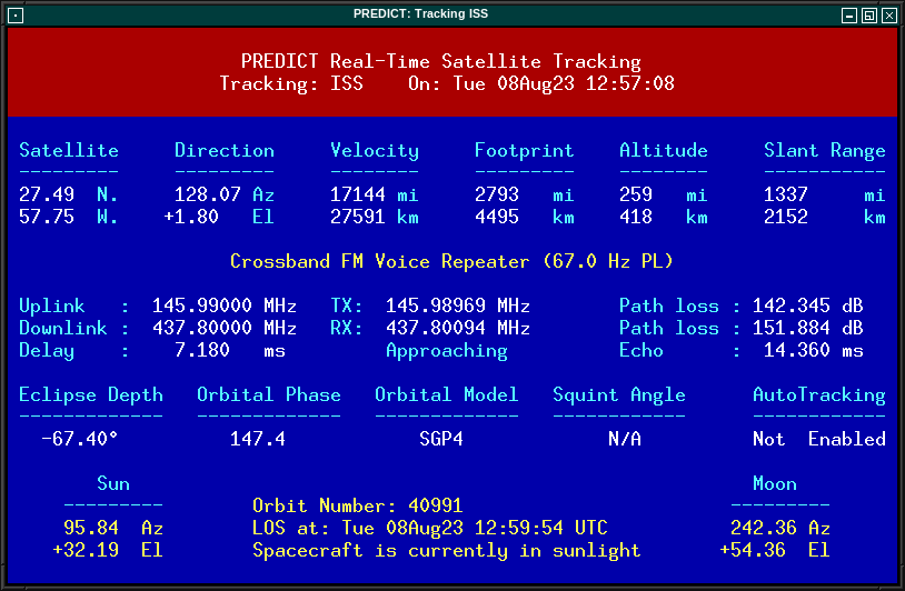
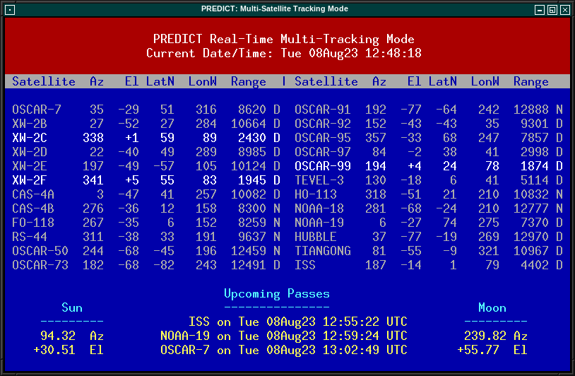
PREDICT is currently used for satellite tracking applications at the NASA/Goddard Spaceflight Center, the U.S. Naval Research Laboratory, Stanford University, and the European Space Agency. The latest version may be downloaded via the Internet for either Linux or DOS-based operating systems. See the PREDICT Website for more information on PREDICT software.
PacsatTools is an excellent addition to the PB/PG Pacsat communication suite by Bent Bagger, OZ6BL, and may be downloaded from ibiblio.org.
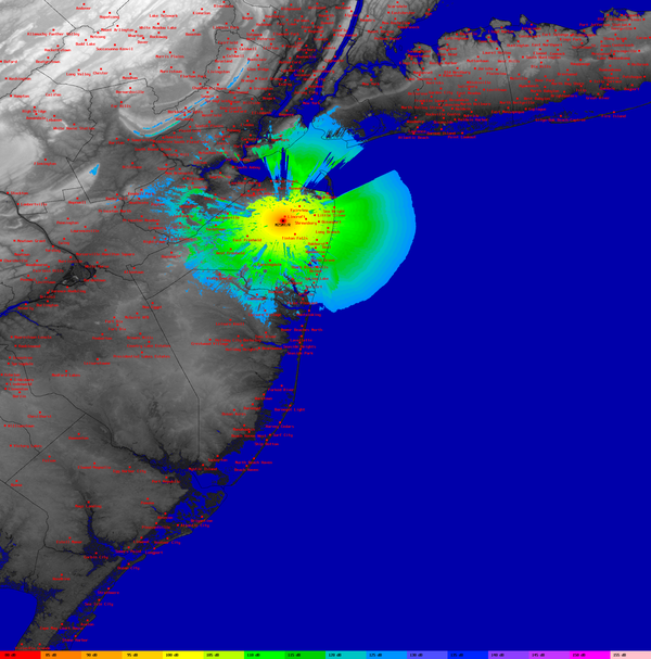
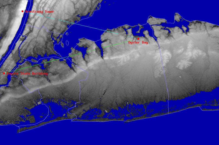
SPLAT! provides site engineering data such as the great circle distances and bearings between sites, antenna elevation angles (uptilt), depression angles (downtilt), antenna height above mean sea level, antenna height above average terrain, bearings and distances to known obstructions, path loss and received signal strength based on the Longley-Rice Irregular Terrain Model, and minimum antenna height requirements needed to establish line-of-sight communication paths absent of obstructions due to terrain.
SPLAT! produces reports, graphs, and highly detailed and carefully annotated topographic maps depicting line-of-sight paths, path loss, and expected coverage areas of transmitters and repeater systems. When performing line-of-sight analysis in situations where multiple transmitter or repeater sites are employed, SPLAT! determines individual and mutual areas of coverage within the network specified.
Applications of SPLAT! include site engineering, wireless network design, amateur radio communications, frequency coordination, communication system design, and terrestrial television and radio broadcasting.
Please visit the SPLAT! Website for additional information.


|
John Magliacane Amateur Radio Operator: KD2BD |