"That is wild
stuff!!"
Natures Funhouse
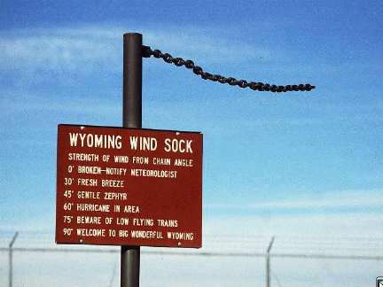 As my predecessor at
the ACRC now knows, Wyoming can be pretty windy!
Visit Jan Curtis, State
Climatologist of the State of Wyoming
The National Weather
Service Radar 88 Doppler Radars (WSR-88D's) are amazing wonders
of science and technology. Here are a few images that demonstrate
their awesome abilities and ideosyncracies...
As my predecessor at
the ACRC now knows, Wyoming can be pretty windy!
Visit Jan Curtis, State
Climatologist of the State of Wyoming
The National Weather
Service Radar 88 Doppler Radars (WSR-88D's) are amazing wonders
of science and technology. Here are a few images that demonstrate
their awesome abilities and ideosyncracies...
 Doppler Weather Radar,
like regular radar, can detect precipitation. This is the type
of radar shot that you most commonly see on the television. This
image is an example of base reflectivity, meaning that the radar
waves (10 cm microwaves) are reflected back to the dish by precipitation.
The heavier the precipitation (or lumber being churned by the
tornado) the darker the color. This image was taken of the supercell
thunderstorm that dropped a tornado through the areas SW of Oklahoma
City on May 3, 1999.
The feature on the
southwest corner of the storm that looks like a hook, is called
a hook echo, oddly enough. The hook echo is an indication of a
mesocyclone, the large scale circulation that gives birth to a
tornado itself.
Doppler Weather Radar,
like regular radar, can detect precipitation. This is the type
of radar shot that you most commonly see on the television. This
image is an example of base reflectivity, meaning that the radar
waves (10 cm microwaves) are reflected back to the dish by precipitation.
The heavier the precipitation (or lumber being churned by the
tornado) the darker the color. This image was taken of the supercell
thunderstorm that dropped a tornado through the areas SW of Oklahoma
City on May 3, 1999.
The feature on the
southwest corner of the storm that looks like a hook, is called
a hook echo, oddly enough. The hook echo is an indication of a
mesocyclone, the large scale circulation that gives birth to a
tornado itself.
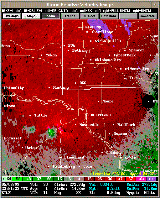 The real value of the
Doppler radar is revealed when it is switched into storm relative
velocity mode. The Doppler Effect, for those who aren't hopeless
nerds like me, is denoted by a shift in frequency of an emitted
wave when the emitter is moving relative to the observer...in
other words...it is why the horn of a train sounds to drop off
as it passes you. When the train is moving towards you, the frequency
emitted by the horn 'sounds' higher, but as the horn (the emitter)
moves away, the sound (the emission) sounds lower.
Doppler radar uses
the same principle...a particle traveling away from the radar
causes a subtle shift in the frequency of the reflected radar
wave. The opposite shift is caused by a particle moving towards
the radar. This way, the radar can "see" the movement
of the winds within a storm, which is valuable.
The image above shows
an area of light greens, or movement toward from the radar, right
next to an area of pinks, which indicates movement away from the
radar. When an area of "away" and an area of "towards"
are right next to each other (called a couplet), that is an indication
of tight circulation, the mesocyclone.
The real value of the
Doppler radar is revealed when it is switched into storm relative
velocity mode. The Doppler Effect, for those who aren't hopeless
nerds like me, is denoted by a shift in frequency of an emitted
wave when the emitter is moving relative to the observer...in
other words...it is why the horn of a train sounds to drop off
as it passes you. When the train is moving towards you, the frequency
emitted by the horn 'sounds' higher, but as the horn (the emitter)
moves away, the sound (the emission) sounds lower.
Doppler radar uses
the same principle...a particle traveling away from the radar
causes a subtle shift in the frequency of the reflected radar
wave. The opposite shift is caused by a particle moving towards
the radar. This way, the radar can "see" the movement
of the winds within a storm, which is valuable.
The image above shows
an area of light greens, or movement toward from the radar, right
next to an area of pinks, which indicates movement away from the
radar. When an area of "away" and an area of "towards"
are right next to each other (called a couplet), that is an indication
of tight circulation, the mesocyclone.
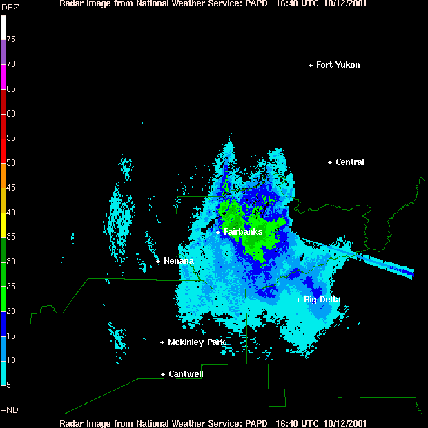 This radar image was
taken from the Pedro Dome WSR-88D several miles north of Fairbanks
on a snowy October morning. The straight streak extending to the
right of the precipitation is not snow...what could it be?
Remember: it is morning.
The streak is actually the sunrise. The Sun emits radiation in
all manner of spectrums, including the 10cm microwave band, which
the radar is programmed to recieve.
To see more about this
phenomenon, visit this Storms
Precdiction Center "Cool Image" page.
More weather fun this way...
This radar image was
taken from the Pedro Dome WSR-88D several miles north of Fairbanks
on a snowy October morning. The straight streak extending to the
right of the precipitation is not snow...what could it be?
Remember: it is morning.
The streak is actually the sunrise. The Sun emits radiation in
all manner of spectrums, including the 10cm microwave band, which
the radar is programmed to recieve.
To see more about this
phenomenon, visit this Storms
Precdiction Center "Cool Image" page.
More weather fun this way...