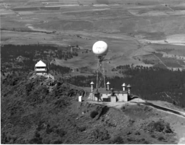
This is an aerial photo taken from an Air Force Fighter Jet from Stead AFB Nevada in the early 1950's, I am not sure of the date but I will guess it to be 1952. I would be very interested in knowing the exact year? It was taken from just over the South side of Thompson Peak. The structure on the left was the old Thompson Peak Lookout (no longer there) and the building on the right with the Tower and Radom on top was the Furthest South early warning Radar site in the USA, or so I have been told. The lower part of that building is still on the Mtn. The valley between the buildings is the Lower Elysian Valley area where two of the Bass Ranches were but most of it belongs to the Mallery's & others now. You can see old Highway 395 where it came over Bass Hill and into Janesville proper and through the scorched area where there was one of three lightning caused fires that burned a lot of Pine trees on the North side of 395. I believe that fire was in the fall of 1951 as I was out of Kindergarten and I believe I had just started the 1st grade. Just to the right of the lookout in the trees you can see the dirt coming up to the sand pit just up the road a mile or so from my home on the corner of Pine St. and Cunningham Lane. I remember hearing and on at least one occasion seeing the noisy Helicopters taking supplies, crew changes and or fuel up to the Radar site when I was just a little tyke. I remember seeing the polite men in uniforms coming into my Grandparents place of business on Janesville's main Street for a Hamburger or a cold one. (The Pines Bar & Cafe across from what used to be Rainey's Market.) Terry L Cobb SR.
Back To Susanville Picture List
E-mail: [email protected] 
Webmaster: Blake Hutchinson KF6ELU
Updated: January 6, 2019