GJ7JHF
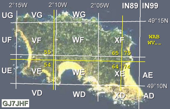
Grids and locatorsRadio amateurs are particularly interested in range - how far they've reached from one station to another. An easy method of identifying a location is to work out a grid system such that any location is within a simply numbered/lettered 'locator' square. It is a lot easier to refer to a square such as IN89wf or WV65 than the more precise location 2-06-00W 49-14-49N (or WV655554) - this example being that of Jersey's Les Platons transmitter mast (BBC radio).Many amateurs have a map showing the grid/squares, and set themselves the challenge of working stations in as many squares as possible, shading in each box on the map as they go. There are even awards available, if certain numbers of squares are worked in particular regions. On this page we'll have a look at the various grid reference systems used. This page came about because I'd been wondering for ages what the Jersey WAB squares were. The WAB websites seem reluctant to show maps and simply listed WV54, WV55, WV64, WV65, WV74, and WV75 as 'JER'. I'm a curious fellow (in many ways) so I wanted to know more. Much web-searching later (what else is there to do in an office lunch hour in winter) and I had it figured out to my satisfaction. I thought I'd share what I'd found. Another lunch hour or two whiled away :o)
Maidenhead (i.e. IN89)This system was agreed at a 1980 meeting of European VHF managers held in Maidenhead near London. It is based directly upon latitude and longitude. The earth is divided into 18 x18 'fields' (324 in total) of 20 degress east/west (longitude) by 10 degrees of north/south (latitude), Jersey being in India November. Fields range from AA at the south pole 180-160W (AR at the north pole above) up to RR at the north pole at 160-180E. See http://www.qsl.net/hb9dsu/faq.htmlSquares are 2 by 1 degrees (fields divided by 10 x 10), see the nice UK map at http://www.qsl.net/ei7gl/locsqr.htm - Jersey's IN89 square runs from 4-00-00 W to 2-00-00 W and from 49-00-00 N to 50-00-00 N. Squares are then divided by 24 x 24 into subsquares (like IN89wf), using the 24 letters A to X. Subsquares are thus 5 x 2.5 minutes (12th of a degree long x 24th degree of lat), always about 4.63km N/S (due to the even spacing of lines of lat.) but varying with latitude because line of longitude converge at the poles. 5 minutes (12th) of a degree around the equator is 9.27km but at Jersey's latitude this falls to 6.05km for a subsquare width (9.27 x cos(49.22)) - the subsquares are as square as they get at 60 degrees north as cos(60) is 0.5 :o) I don't believe in duplicating too much information when it's already available around the WWW, so please visit the following site for yet more details : http://www.algonet.se/~jonit/fieldlist/maidenhead.htm. To work out your locator, first find your longitude and latitude. This can be as simple as using your GPS (or borrowing one), or consult an OS map in a shop or library. There are methods of calculating the locator that rely on maths, and that can be quite off-putting to some people, so here's an example using little more than very basic counting, some understanding of what's going on, and perhaps a little straightforward subtraction. You *can* follow it, I assure you!
Les Platons example, using 2-06W and 49-14N. Working east from the 180-00W dateline, '180 to 160 W' is column A,
but that's not the right column... count onwards... '20 to 0 W' is column I, that's where we are. First letter is I.
WAB (NGR/UTM - i.e. WV65)WAB means the Worked All Britain award scheme. This is based on a grid used on Ordnance Survey maps, with 100 x 100 km lettered squares, subdivided into 10km numbered squares. The grid letters used by the OS for National Grid References can be found in a map on their website http://www.o-s.co.uk if you search hard enough (try 'Free and Fun' ... "Understand mapping" ... "Paper mapping" ... "National Grid") - if you have a PDF viewer you can try their 2 page http://www.ordnancesurvey.co.uk/downloads/Natgridpdf/20241.pdf document. These letter pairs are unique to the OS, and are not part of the Univeral Transverse Mercator system. The Channel Islands are not included in the NGR system, so we use UTM instead and our square is WV.UTM involves the whole planet being sliced into 60 parts of 6 degrees of longitude, like a chocolate orange if you like. Zone 1 starts at the international dateline, and the others are numbered eastwards. Most of England is within Zone 30 (but if you're in east of the Greenwich Meridian you're in Zone 31). Each Zone is subdivided into 8 degree slices of latitude, with GB in 30U between 48 and 56 degrees North (with apologies to viewers in the north of Scotland). The page http://www.maptools.com/UsingUTM/UTMdetails.html explains the zones nicely, and their http://www.dmap.co.uk/utmworld.htm page shows a map of the zones. The grid for Zone 30 is all referenced to a single point at 3-00-00 W on the equator, being in the center of the 6-00-00 W to 0-00-00 W zone. The distances (in metres) North/South and East/West from this point give northings and eastings, and the grid on 1:25000 OS maps is drawn in 1km squares. The center of the zone is given a 500,000m offset for eastings, to keep values within a specific range. The Whiskey Victor square encompassing the Channel Islands runs from longitude 3-00-00 W to about 1-37-38 W, with VV to the west and XV to the east. The latitudes are from 48-44-57 to 49-38-54 North (approx) with WA to the north and WU to the south. This WV square bounds the distances 500,000 to 600,000 metres eastings in UTM Zone 30, and 5,400,000 to 5,500,000 meters of northing. The Jersey OS map has a 53 to 74 horizontal scale (553,000 to 574,000m) and a 43 to 58 vertical scale (5,443,000 to 5,458,000m). Les Platons, as an example, is roughly 65,500m from 3 degrees West (565,500m with the 500km offset), and 5,455,400m above the equator. All according to the scales along the edges of my OS map, anyway. The WV square already denotes the 500,000m and 5,400,000m parts, so within the WV square the important numbers (to 3 digits) are the 655 and the 554. Following the coordinate convention of so many units along, then so many units up, the grid reference is the square, the easting and the northing all combined as WV655554. For WAB, the grid reference WV655554 is a little bit too precise, to within 100m. The WAB squares are a hundred times larger (10,000m), so discard a little precision and take just the 6 from the easting and the (first) 5 from the northing. Les Platons thus falls within the WAB square WV65. Phew! If your browser supports Javascript, try the excellent converter page at http://www.dmap.co.uk/ll2tm.htm - This allows you to enter lat/long coordinates and shows you your UTM locator. Dial in the Les Platons coordinates taking care to click the E/W button as appropriate, and select UTM from the drop-down list. Press convert and it'll report the reference as a rather full 30UWV 65505 55406. Excellent stuff, and note that each calculation takes place locally - i.e. you can disconnect from the internet and the page will still work.
QRA / QTH locators (i.e. AB34e)A disused system from the 1950/60s, replaced by the Maidenhead Locator system in 1980. The QRA system was devised in Germany, and adopted at the October 1959 meeting of the VHF Working Group in The Hague. It started logically enough with two-letter squares for 2 degrees of longitude and 1 degree of latitude, the same squares as the newer system in fact, for example the old YJ square is the new IN89. The first section of the grid ran eastwards from the Greenwich Meridian to 40-00-00 E (A- to T-) and from 40-00-00 N to 66-00-00 N (-A to -Z), and then the first letters U to Z were used to include from 12-00-00 W back to the meridian.The numbers relate to how each square was divided into 80 smaller squares : 10 x 12 minutes longitude, and 8 x 7.5 minutes latitude - 01 to 10 along the top of a square, 71 to 80 along the bottom. So far so good, apart from using 01 to 10 instead of a more calculation-friendly 00-09/70-79 (there's no 00!) but the real fun came later...
The Region 1 Conference in Malmo (1963) introduced third sub-divisions : each letter/numbered square was divided
3 by 3 into 9 yet smaller squares a to j (no i). These squares are therefore 4 minutes of long., versus 2.5 minutes of
lat., the most bizarre feature being a spiral layout that would make computer conversion interesting (!) :
The Region 1 Conference in Scheveningen saw the system renamed as the QTH-Locator. The area covered went just far enough west to include all of Ireland, but not far enough south to include all of Spain or Italy. With various similar systems in use around the world, many with duplicate square descriptions, by the 1970s the time was right to introduce a global system to suit everyone (especially computer programmers!). Thanks to http://www.scit.wlv.ac.uk/vhfc/iaru.r1.vhfm.4e/3L.html and the Radio Communication Handbook (5th Edition, RSGB 1982) - in particular big thanks for the misprint in the second worked example!!
Les Platons example, using 2-06W and 49-14N. Working back from the meridian, '2W to 0' is column Z, but that's not
the right column... '4W to 2W' is column Y, that's where we are. First letter is Y.
RETURN / RETOUR
You have been reading
|