|
G3VGR
|
Hochschwarzwald - Menzenschwandertal
|
For today, I had planned a easy walk to visit the Menzenschwand Waterfalls, which mark the northern end of the Menzenschwand Glacial Valley.
This was just as well because I hadn't fully recovered from yesterdays strenuous hike during the afternoon heat.
It was another hot sunny morning as I caught the 8AM bus from Titisee. The bus was very full with schoolchildren on a class outing.
I've noticed that most days there seems to be countless schoolchildren out on day trips. This never happened when I was at Junior School over 60 years ago, but at least we had free milk every day as recoompense.
Again I was treated to superb views of the Hochschwarzwald as the bus climbed the Feldbergpass through the Bärental.
Unlike my last ride up the Feldbergpass, this time I alighted at the correct bus stop, next to the Caritas-Haus, a large rehabilitation centre for mothers and children, locateed in a nature reserve.
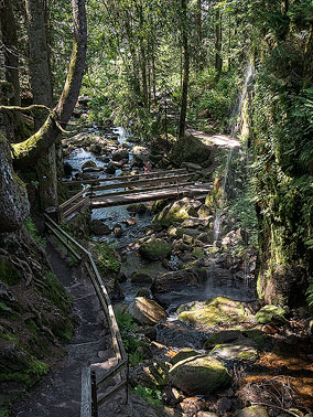
I departed the main road and followed a narrow path into the nature reserve and walked steeply downhill through a forest.
Despite the hot, dry summer weather, the path was quite muddy and slippery in places due to tiny streams running down from the Feldberg, but I was enjoying the peaceful silence of the forest as I made my way downhill.
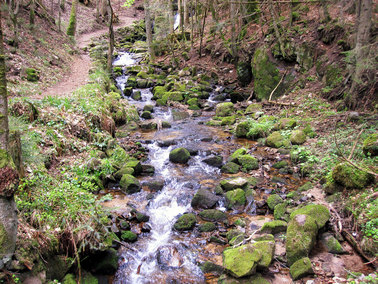
After less than a mile, the forest path ended by a bridge over the Menzenschwander Alb at Marialoch.
A small waterfall just above the bridge broke the silence.
I was now on the Albsteig which continued downhill along a gravel service road.
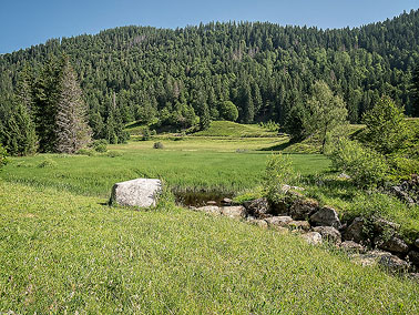
The trail exited the forest into a wide valley and I was now walking through a beautiful meadow.
Looking back towards the Caritas-Haus, one can see this area was formed by the Feldberg Gletscher during the ice age.
A little further on, I reached the Klusenmoräne, a moraine left by the glacier.
The almost 15-meter high mound is one of the most impressive reminders of the former glaciation of the Feldberg area.
I lingered for quite a while, appreciating the beautiful scenery here.
However I always had one eye on my watch to avoid missing one of the infrequent buses to St. Blasien.
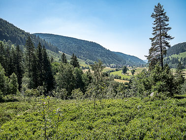
The gravel road now became a metalled road which continued through the meadows passing grazing cows that were sheltering in the shade under trees along the river.
Just before reaching the waterfall area, I took a path uphill to a viewpoint.
Unfortunately, dense vegetation impaired the views down the valley.
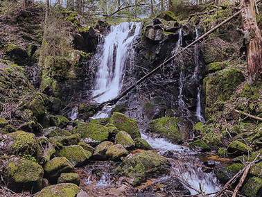
I went back downhill and arrived at a narrow ravine where the Menzenschwand waterfalls are located.
As it was a Thursday morning, the area was not busy with visitors.
The waterfalls didn't impress me too much, possibly due to summer's lower water flow, but I was intrigued as to why this ravine materialized in the wide valley landscape.
It was very hot now and I had hoped to get a refreshment at the Zum Cuckoo café, but it was not yet open.
Nearby, I noticed some goats wandering free. It seems they are used for landscape maintenance to help preserve the unique vegetation of the high valley.
Mindful that I only had 90 minutes before the next bus departed, I made my way towards the village that I could see in the distance.
Menzenschwand comprises three villages, Vorderdorf, Mitteldorf, and Hinterdorf (rear village).
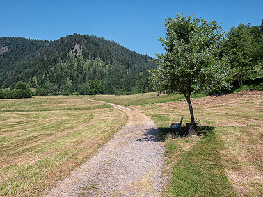
My destination was the Hinterdorf and getting there was easy walking along a gravel path through pretty meadows.
At various intervals along the path, someone had thoughtfully planted occasional trees with benches underneath. I chose one that was near a large outcrop of wild lupins as a place to eat my lunch.
It was very pleasant sat under the shade of a tree, looking at the superb scenery around me.
After my rest, I walked the short distance to Menzenschwand Hinterdorf and had sufficient time for a beer at the Gasthaus Birkenhoff prior to catching the 7321 bus to St. Blasien.
The bus passed some nice scenery on its way to the Busbahnhof. I was impressed by St Blasien during my stay whilst walking the Schluchtensteig in 2012 and was pleased to be revisiting.
It is a beautiful town, nestled in the valley and the River Alb runs through the centre. Various bridges cross the river, linking parts of the town.
I walked around the well-maintained Kurpark prior to visiting the jewel of the town, the Dom Sankt Blasien.
With a diameter of 46 metres and a height of 63 metres, the dome of this cathedral is the third largest north of the Alps.
The interior is also very impressive. After my visit, I ventured back out into the hot sun to complete the day with a walk up the Windbergschlucht which is next to the town.
This is another wild gorge in the Hochschwarzwald where the Windbergbachle flows noisily down from the Windberg Wasserfall on its way to join the Alb in St Blasien.
Following the Schluchtensteig signs, I walked along narrow paths and over small footbridges and steps, accompanied by rushing water and the typical flora of the southern Black Forest.
After reaching the waterfall at the top of the gorge, I returned to the town's Busbahnhof and caught a bus to Seebrugg where a train took me back to Hinterzarten.
This had been quite an easy day and I had managed to cope with the excessive heat better too.
The weather across central Europe was still extremely hot and showed no intention of cooling off for the duration of my walking holiday.
In the evening, I walked to the CouCou restaurant at Hinterzarten Tennis Club where the day's special was Liver with Bratkartoffeln - Yum!
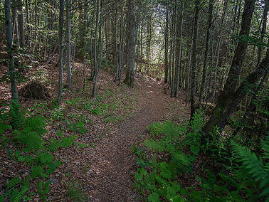
Path through the forest from Caritas-Haus
|
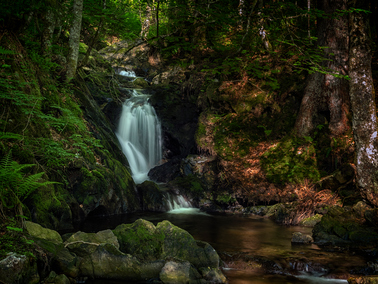
Marialoch Waterfall
|
|
|
|
|
|
|
Klusenmoräne
|
View down the valley towards Menzenschwand Hinterdorf
|
Menzenschwander Wasserfall
|
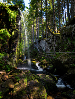
Menzenschwander Wasserfall
|
View back up the valley from the meadow
|
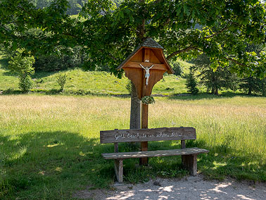
Nice place for my picnic lunch
|
|
|
|
|
|
|
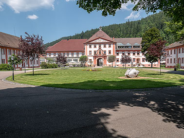
St. Blasien Kurpark & Rathaus
|
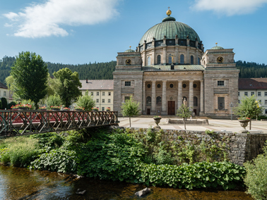
Dom Sankt Blasius
|
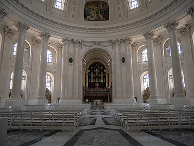
Interior of Dom St Blasius
|
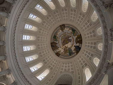
The dome
|
Along the Windbergschlucht
|
Windberg Wasserfall
|
[Home]