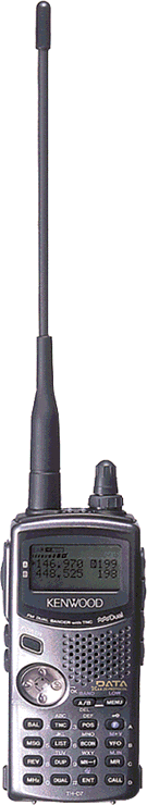
The Kenwood TH-D7A(G) Handheld Transceiver
By Dave AD7DB
Revised July 7, 2003
 I went for this one for a variety of reasons.
Mainly, I didn't want to really have to build anything or kluge together a lot of stuff.
And I thought it would be super cool to carry just the radio and a GPS on my belt,
and beacon my position while on foot at a convention or special event.
(Ha. See below for a reality check.)
I went for this one for a variety of reasons.
Mainly, I didn't want to really have to build anything or kluge together a lot of stuff.
And I thought it would be super cool to carry just the radio and a GPS on my belt,
and beacon my position while on foot at a convention or special event.
(Ha. See below for a reality check.)
Here are the good and bad points I have been finding.
Good Points:
This is a self contained portable unit, and even without a GPS attached, you can display locations,
bearings, distance and other data for up to 40 stations.
In that regard it works very well.
I remember how I had to hook up a TRS-80 Model 100 laptop to a klunky TNC and then to a radio.
You also had to run power cables to most of it. But this is how you could operate
packet in a portable situation back in the late 80's.
Now you can connect this radio to your laptop using one cable, and away you go.
Bad Points:
That rubber duck dummy load that Kenwood has the nerve to call an antenna
doesn't get your signal out at all.
You can't be heard with the thing.
You MUST use a good external antenna with this unit.
I was warned about it in advance, but I didn't think it would be this bad.
The 5 watts maximum output is just enough to qualify in a busy place like
Southern California. Most other mobiles out there are running 10 watts or more,
base stations 25 watts. Your pipsqueak signal needs all the help it can get.
The corny demo movie they included on the CDROM (which came with the PC cable)
shows some people using it from inside their car. It's in a holder on the dash and using
the rubber duck antenna. That doesn't work. Nobody can hear you.
I'll have to do some checking to see how this might work out in a very
localized environment, such as at special events, where you might be close
enough to another station for them to hear you more easily.
I am not sure if this is a bad point or not:
the antenna connector is a screw-on SMA type, not the BNC like many other HTs use.
I have been told that SMA is a better connector, RF-wise. I hope it's sturdy.
To use an external antenna, you need some kind of adapter to go to
either a BNC or to an SO-239 in order to use a more common antenna connector.
WA3HRL
has info on some substitute antennas and adapters.
You cannot use the radio while it's connected to the standard wall charger.
It draws its power off of the charger, not the battery.
You'll need to connect it to a good power supply, or use a 12V cable in the car.
Considering that it takes up to 16 hours to recharge the battery, you could be QRT for a while
unless you invest in another battery - and then you need something that will charge the
other pack that's not in the radio. I don't want to buy any more accessories yet until
I know where I stand in regards to my expected uses for this.
More D7A Opinions and Resources:
Manufacturers Page: Kenwood D7A(G) APRS Handheld Radio.
Product Reviews: eHam: Kenwood TM D7A(G)
- many opinions from actual users.
APRS Discussions: eHam: APRS Topics - has several concerning the D7A radio.
Resources: Radiohound. Has a lot of good information and links.
Yahoo Groups: TH-D7. Lots of active discussion here.
8/29/2002:
I got it hooked it up to an external mag-mount antenna on my vehicle.
With the GPS on the dashboard, things worked OK.
I had the D7A's audio muted
(a little trick,
you use CT squelch on a data memory channel, and it mutes it so you don't
have to keep changing the volume level if you change from data to voice memory channels).
It was set to beep only on "mine" (when it heard my own signal digipeated) so that I could gauge
how well it worked.
Now the APRS network could hear me more often than not; and in the
crowded radio conditions of
Los Angeles, with packets flying every other second on 144.39 MHz, and using only 5 watts out at
1 minute intervals, I thought it was doing as well as can be expected.
A few weeks ago, I took it down to Escondido to the
ARRL Southwestern Division Convention.
Since there were several APRS experts there (with a great setup at the special events station)
I could try out different parameters on my radio right there and see the results immediately.
One of the things I goofed around with down there was the "position ambiguity" setting.
I wanted to see how greatly it affects your apparent position.
I came to the conclusion that it is probably best to leave that turned off,
unless you really have some need to be vague about your location.
It seems the precision of coordinates over APRS is poorer than that from the GPS unit itself.
The APRS gets its coordinates in degrees and minutes, down to 1/100th of a minute,
such as 118 degrees, 18.34 minutes west longitude.
By my estimates, in this area that comes down to about 100 feet resolution.
No wonder FindU
was sometimes thinking I had driven off of the roadway!
Most of the time this level of precision will be acceptable, but it's something to be considered.
Add that to any other loss of precision due to poor GPS reception and you could have some trouble
in a geocache contest!
Now I've got another head scratcher. I had my GPS give me the reading from outside
on top of the parking structure at the Knowledge Adventure building (Howard Hughes Center)
where I work. The GPS fed the numbers into the D7A, which said I was located precisely at
33° 58.53' North, 118° 23.46' West.
But the information that FindU received says:
Raw packet: AD7DB-7>APK001,WIDE2*,qAS,KG6EHS:@290315z3358.56N/11823.30Wk000/000/Mic-E/M2/In Service>
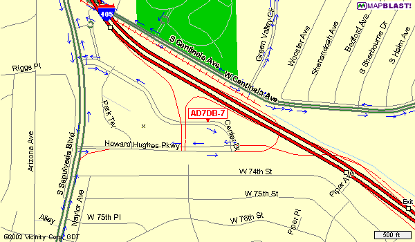
This places my position apparently on Center Drive in front of the
Univision Building,
several
hundred feet east of my actual location (which is about where I put the X on the map).
Note that it changed the numbers.
33° 58.53 got changed to 58.56,
and 118° 23.46 got changed to 23.30.
How did that happen?
I don't think it's confusing decimal degrees here, or decimal minutes with minutes and seconds.
There is a possibility that it just corrupted those digits, after all it is over the radio,
but I want to experiment some more and see.
Also note that the APRS ident APK001 is in there, yet the radio is set to use APK002.
This is supposed to identify this particular Kenwood model, as if anyone out there but Kenwood cares.
Weird things are going on and the truth is out there.
9/5/2002:
Was playing around again with the D7A and the Garmin GPS III Plus.
One feature I hadn't experimented with too much as yet is the ability to send info
from the D7A back into the GPS. So I did. (It's
Menu 2-3,
set it to NMEA 6 digits.)
Sure enough, truncated callsigns started showing up as waypoints.
The ones in motion even moved, too!
The full callsign with SSID gets truncated to the last six characters on the Garmin.
Thus, "AD7DB-7" becomes a waypoint of "D7DB-7"; if it were "AD7DB-12" it would show up as "7DB-12".
Without any SSID it will show a full callsign.
(I tried other data output formats to see if this can be made to accept more than six characters.
No others seem to work.)
This makes the radio plus the GPS together a rather powerful
and completely portable visual tracking system!
I suggest, before trying this, to set the distance limit (Menu 2-7)
to something like 10 or 20 miles, depending on how active APRS is in your area.
Because I had it wide open, this experiment soon loaded my GPS up with over a hundred new waypoints,
some of them ridiculously distant.
(It seems some people like going out to WIDE7-7.)
It was a bit of a pain to go through afterward and delete them, while leaving the 80 or so
existing waypoints I wanted to keep.
The GPS can receive data from the D7A (Menu 2-3) even if the D7A is not currently set to
read positions from the GPS (Menu 2-2). This means you can set specific positions for
where the D7A thinks you are located (Menu 2-4, or POS button),
and you can set a small distance limit (Menu 2-7) of 20-30 miles, and see stations
only from that area plotted on the GPS map display.
If the D7A is set up to read its position from the GPS (Menu 2-2),
then it overrides any of the stored POS settings. The POS button will show the
current latitude and longitude, and also show the altitude, course and speed.
You can store this info "on the fly" to any of the 3 position registers for later use
when it's not using the GPS. I usually keep some semi permanent locations in slots 1 and 2
and use slot 3 for storing a position taken from the GPS.
And, the information in the first two positions, as well as the regular memory channels,
varies based on the saved profiles I keep on my computer using
Kenwood's MCP_D7G program.
I can load different setups based on where I'm going to be using the radio:
around home, a trip out to the desert, going down to San Diego, etc.
I even found a saved profile from
KD6VYV in San Francisco,
so in case I ever go up that way I have a list of his favorite machines all ready to go.
|
In reciprocation...
I offer to fellow TH-D7A(G) hams a somewhat edited version of my home config file
for Los Angeles and Southern California.
What you need to know about it:
The file is in D7G format, and is intended for use with the
Kenwood MCP-D7G programming software,
Memory Control Program for TH-D7(G), version 1.01.
I cannot provide that software to you.
My copy came from the CDROM that was included with Kenwood's PG-4W interface cable.
Since it is Copyright ©2000 by Kenwood, I cannot put it up here for download.
You may be able to find this program and version at Kenwood's web site at
http://www.kenwood.net/index.cfm?do=SupportFileCategory&FileCatID=3
(which is where I last saw it offered for open download).
The data file is offered as-is with no warranty or guarantee of any kind.
Please do not ask me to email it to you. If you can't figure out how to download it, too bad.
The file contains a number of open repeaters, some popular simplex frequencies,
output frequencies of various interesting yet closed repeaters, and some
non-ham aircraft, railroad, and public service frequencies.
It has various frequencies from the L.A. area, Orange County, north up the coast,
and some desert repeaters. It also has some of the common "classic" 2m repeater frequencies,
as well as all 14 FRS frequencies to listen to.
Oh yeah, it also has some common APRS and DX cluster frequencies.
You will need to put in your callsign and other info for your use
and disable the transmit inhibit via the menus if you expect to get on the air.
Here is the file:
Los_Angeles.d7g (8KB Kenwood D7A(G) data file)
Oh, and welcome to Southern California!
|
More Experiments!
Now for an interesting idea, which I plan to try soon on a 200 mile weekend trip.
Set up the D7A and GPS as above, so local APRS stations show up on the GPS map display as waypoints.
Set the distance limit to 10 miles. Set the resolution on the GPS so I can see about that same range,
maybe a little farther.
Then, as I travel, see what becomes of these waypoints. When I move into range, they should begin
to appear on the GPS display.
When I go out of range, what will happen?
I suspect they will just "stick" where they were last reported.
This will be interesting to see, especially if I pass any mobiles coming the other direction!
By the time I get from L.A. to the Colorado River,
there will probably be a swath of these orphan waypoints up to 10 miles each side
of Interstate 10, trailing all the way back to the city.
In a similar vein, suppose while I'm in Blythe I increase the distance limit to about 140 miles,
the distance to the Phoenix area from there, and then just have it monitor for a while
and watch that part of the GPS map display.
Any mobile station poking his nose outside of Phoenix should show up, and then stay on the map
even if he scurries back into town and out of range.
But 140 miles to the west would be nearly to San Bernardino,
so I'd clog up the GPS with everybody from
Palm Springs, Morongo Basin, Imperial Valley,
the whole Colorado River Valley from Laughlin down to Yuma and into Mexico,
the suburbs of eastern San Diego County, most of western Arizona including Wickenburg,
I-10 of course, most of I-8 and parts of I-40, the whole works.
Remember that the D7A only has to keep track of the last 40 stations heard, but the GPS
will remember over 10 times as many waypoints!
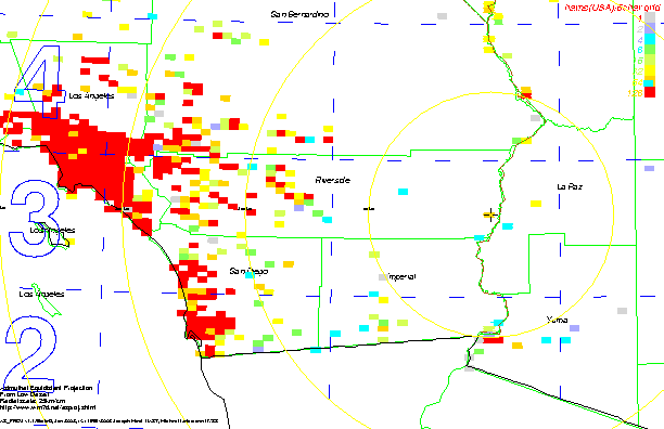
See:
[Current Station Plot,
57 stations seems to be as high as it'll show, which is only about 100 miles.
That's not counting any that later move into range, either!
And my experiment would be out to a full 140 miles!]
[General Map
of the 140 mile radius effective area.]
It might even eventually overload the 500 waypoint limit on the GPS; and then what'll happen?
Will it just not take any more, or will I start losing existing saved waypoints?
Maybe that's not such a great idea...
More info to come.
9/9/2002:
Went this past weekend to the annual
Cal-Net Beach Party where I talked to
several active APRS guys.
I got some answers.
Yes, there are enough stations heard over APRS that it will soon fill up all 500
waypoints on the Garmin GPS III Plus.
When it reaches capacity it will not add any more, nor will you lose any existing ones.
But it's a real pain to have to manually delete these waypoints, especially if there are
some you want to keep. People have already done this, so I sure don't have to.
I may yet try that "trail of waypoints" with the 10 mile range setting for 200 miles along I-10,
just to see what it looks like. But that's the only time I'll try that.
At close range it looks like this is very useful for immediately tracking nearby stations within
a few miles of your position. I walked up and down the bike path a few hundred feet each way
carrying my D7A and the GPS. Others back at the group watched on another D7A unit as it pointed
to my position and showed my varying speed of 3-5 MPH.
I was beaconing every 12 seconds on very low power with a path of just RELAY,
although I'm sure that no one beyond that beach could actually hear me
with the rubber duck antenna.
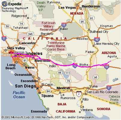
9/16/2002:
Just got back from a getaway weekend in the low desert.
This was my first big trip sending live APRS. Pity I had no internet access or a good way to
find out what I looked like to other stations while I was enroute.
I had set up the D7A and the GPS in my truck to beacon my position
every minute. I had considered using a 5-minute beacon until I was away from the
busier metro area, but after being on the road just a few minutes I was
glad that I was going every minute, because I could tell I wasn't being heard too often.
The APRS beep was set for "Mine" so I could easily note how well it was working.
Uninteresting trip details that you can skip past if you want:
The Friday Night Getaway this time was the worst I'd ever encountered.
The 91 freeway going east was the best bet, according to all of the online traffic maps
that I'd looked at before leaving work.
I-10 (Santa Monica/San Bernardino Freeways) was out of the question as always.
The 105 freeway was open part of the way but bogged down near the 605,
but the 91 seemed most open along its whole length.
So, I headed down the 405 south, which was surprisingly wide open all the way past LAX.
I took the 105 east, then played it real smart when I got to the 110 Harbor Freeway, I headed south
to pick up the 91. I should have stayed on the 105, because the 91 soon clogged up
and STAYED that way, 20 miles an hour all the way east beyond the 605 freeway.
Then it was open for a while, and then got all jammed up again well before the 57 freeway.
I finally got past that, and took the 57 north to join up with the 60 freeway
in Diamond Bar (to avoid the usual traffic jam in the Santa Ana Canyon).
All of these delays cost me an extra hour in getting out of Los Angeles County.
It was past 11:00pm when I finally reached Blythe.
Along the way, I verified for myself that APRS coverage is nearly nonexistent along the
I-10 from Yucaipa to Indio. You'd think with all of the hams and repeaters that
do reach that area that there'd be some APRS digipeaters.
East of Indio the coverage is very good all the way to the Arizona line.
And well beyond, as I found later on.
I did some experimentation on the way outbound.
I set the APRS range limit to 10 miles, which was the lowest setting.
I cleared out the Heard list before getting underway from Westchester,
and set the Waypoint output to OFF.
I could see a lot of indications of ignored stations
(it was saying >P so they were beyond 10 miles away).
When I got to a rest area in Yucaipa, I turned the Waypoint output to ON.
Then I resumed my trip.
That night way out in Blythe, I examined the waypoints collected in the GPS and checked the
Heard list in the D7A.
The map on the right is just a grid square map I generated at
WM7D,
so that you can see the grids mentioned below.
For reference, the Los Angeles area is broken up by DM04, DM14, DM03, and DM13.
Yuma is in DM22. San Diego is mostly in DM12.
DM13 contains Orange, northern San Diego, and western Riverside Counties.
Blythe (where the crosshair is) is in DM23.
The light blue square about 50 miles west is Desert Center.
The light yellow square 25 miles east is Quartzsite AZ.
The yellow circles are 100 km (~62 mile) distances from Blythe.
The red areas are where hams live too closely packed for my liking.

This is where it gets interesting.
My precise location in Blythe was N 33° 36.27', W 114° 36.19',
grid square DM23qo. (You can probably figure out which motel I stayed at.)
Listed on the right are the 20 stations in the Heard list.
That's right, I got within 10 miles of only twenty stations the whole way out there.
The D7A holds up to 40 stations and does not clear this list when the radio is turned off
(such as when I stopped at Yucaipa, North Palm Springs, or in Blythe when I got there).
I wrote them down in the order they were listed, after turning off the TNC so it
wouldn't get any more data. I have omitted the exact coordinates; their grid square
and distance from Blythe will suffice for my discussion here.
I had assumed that a station might cease to be updated in the Heard list
for various reasons:
1. He's beyond the range limit I set, in this case 10 miles.
2. He isn't transmitting WIDE enough to get his callsign "seen"
by more distant digipeaters.
3. No digipeater can hear him at his present location.
4. Or he simply went QRT.
I was transmitting using WIDE2-2 on the way east. On the return trip I used WIDE3-3, although
that's not necessary in L.A.
All I really care about is to make sure my callsign and information make it to an
I-Gate somewhere so they'll show up at
FindU.com and
other live APRS sites.
Now this is what I couldn't understand.
Why are those distant stations still listed near the top?
I came within range of KK6OZ (located in La Habra) when I was going north
on the 57 freeway in Brea.
Why did he remain on the top of the list after I got more than 10 miles from him?
I can only assume it's a flaw in the software. Once a station gets into the Heard list,
it stays at the top of the list if the TNC hears of him,
even if he's now beyond the set distance limit.
If he never came into range then he would never have become listed at all.
This behavior is not how I would have expected it.
Kenwood either had some reason for doing it this way, or it's just an oversight.
To me, the right way would be to ignore further position reports if the
station is now beyond the range limit (whether he moved or I moved).
If more nearby stations are heard, I should expect the distant one to be pushed down
the list, the same as if he'd gone QRT.
A check of the info from KK6OZ showed that he was running
with WIDE4-4. No wonder his position was being sent out hundreds of miles!
This would seem excessive, and it's the
opinion of some
that this setting is inappropriate for the Southern California area.
(I have seen some fixed stations as far away as Colorado show up on local APRS.)
However, W6JQ seemed to be more in line with the recommended settings of WIDE2-2.
Some stations didn't get their location plotted.
KB6RCT-9 was sending data that the D7A didn't recognize, and
K6KCY's GPS was apparently turned off, because his data had lots of commas.
Now, how did they end up in the list?
When I stop and turn off the truck, it cuts power to the radio and GPS. The GPS shuts off
gracefully, complete with a 30 second countdown timer. The radio just goes off.
When I restarted the engine, what I did was to turn the GPS back on, let it get
back in sync again.
Then I turned on the radio.
Now it takes a second for the handshaking to get going, and during that time
the radio, lacking any input from the GPS, resorts to a 00/00 coordinate.
Then a chirp from the radio indicates it's getting positional data again,
and we're fine. But in the meantime it may have received some packets,
and if any of them were also defaulting to a null position of 00/00,
the radio thinks, "Yep, I guess they're within range!" and they get added to the list.
(Either that, or they were sending good positions while I was within range of them,
and then stopped sending good data but were kept in the list.)
I have thought of a way to prevent this:
Turn off the beacon. Turn off the TNC. Now turn off the radio, and then the GPS.
Then turn off the truck.
When returning to the truck: start the engine. Turn on the GPS and let it get in sync again.
Turn on the radio. Now here's what I didn't do before: change it to a different channel!
Turn on the TNC. Let it get the handshake going with the GPS.
Then move it back to 144.39 MHz, and then turn on the beacon again.
#4 on the list is a case that I expected. N7CS, apparently a big rig according to his icon,
was heading west on I-10.
His last listed position was near Whitewater, moving west at a good speed.
I was heading east, he was heading west, so at some point we must have passed each other.
All the rest of them from #7 on through the end of the list seem to be
consistent. The distance climbs slowly, yet with a considerable
variation which is to be expected.
Oddly, I didn't get any positions on anyone in the Coachella Valley area
(except for N7CS), nor did I get anything from the various digipeaters
that I know I should have come in range of. Such as
KF6BM-10 at Cactus City, and
W6SCE-11 on Chuckwalla Mountain.
I am sure they must have their beacons appropriately set at infrequent intervals,
but it is very likely that they were the ones digipeating me as I passed through the area.
I intend to repeat this experiment in the future.
Later in the trip, I increased the range to 30 miles. Now various local stations came into
view on the GPS, but not so many that it became overloaded with useless waypoints.
Another thing I tested during this trip was whether the APRS transmitter
would cause problems with my main 2M/440 radio,
permanently installed in the truck for FM voice work.
Despite the antennas being just a couple of feet apart on the roof,
there was no problem on either band!
The AM car radio wasn't affected, but the FM (broadcast) radio
gave a quick yet quiet "hissss" whenever the D7A transmitted.
10/01/2002:
Various experiments I have done since.
Experiment:
(status)
|
TH-D7A(G) settings:
|
What this does:
|
Results:
|
Locals Only
(done that)
|
Range limit 10 miles; position either manually specified or obtained from GPS.
|
Shows all stations located within the specified range.
|
As expected. This is straight out of the manual.
However, any stations with a 00/00 position due to their GPS having lost
reception still appear, no matter where they are, if they are
digipeated by a station that the radio heard directly.
If you're using a GPS make sure it keeps up with you, and beware of parking structures,
tunnels, caves, or thick overheard foliage.
|
Who's Out Thataway
(done that)
|
Range limit 30 miles; position manually specified at some distant point.
|
Shows all stations located within the specified range from that location.
|
Shows stations located out in that area which are using a Wide enough path
to be locally digipeated in this area. The experiment I did was for Blythe CA (DM23qo)
which is about 200 miles from my QTH (DM04se).
Paths of WIDE3-3 and above seem to regularly make it back into L.A. from there.
|
Who's Really Far Out?
(done that)
|
Range limit 600 miles; position manually specified at some distant point.
|
Shows all stations located within the specified range from that location.
|
This experiment shows stations located outside the local area
which are using a Wide enough path to be locally digipeated here.
In this experiment, I set the coordinates for a location just outside Denver CO:
Lookout Mountain, 39°44.00'N, 105°14.36'W (DM79jr)
which was practically on top of
Buffalo Bill's Grave
(as recorded on site by me in May 2002).
This covers a very wide portion of the Western U.S. Denver is a little over 800 miles away
from L.A., so with a distance range of under 600 miles it showed all of the non-local stations
that were using a high WIDEn-n setting.
There were a number of them, but few that seemed to be sending a beacon very often
in order to not bother too many users way outside their area.
|
Mark the Locals
(done that)
|
Range limit 10 miles; position input from GPS; waypoint output NMEA to GPS; beacon off.
|
Plot waypoints for local stations into GPS.
|
This generates waypoints in the GPS for local stations.
It truncates the name to the last six characters of the callsign+SSID.
The GPS will show these locations as waypoints, and update them if they move.
|
Mark the Non-Locals
(done that)
|
Range limit as needed; position manually specified to some non local location;
waypoint output NMEA to GPS; beacon off.
|
Plot waypoints for non-local stations into GPS.
|
Similar to above, the difference is that it plots stations that are
within a radius of some other area.
In other words, it's like some of the above experiments
but it also plots them into the GPS as waypoints.
|
|
The Dead Zone?
|
Position manually specified;
Beacon every 1 minute;
Path WIDE1-1;
Beep on Mine;
No range limit;
Power level 5 watts using a good external antenna.
|
See if you are passing through some dead zones.
|
This is useful to help map out what areas do not have reliable APRS coverage.
A GPS is not needed for this.
The WIDE1-1 is used instead of RELAY or WIDE because the modern APRS networks
are phasing out those digipeater aliases. Yet, we do not need to overburden the
digipeaters in the area. We just want to know if we are heard by a wide coverage relay.
Because it beeps when it heard your own position digipeated, you will know by the
absence of such beeps that you are not getting heard out there.
This may be due to either a marginal coverage area, or by too many other stations
competing for the airtime, so your signal doesn't make it through
- a common occurrence in the Los Angeles area.
|
The Dead Zone, Part II
(done that)
|
Position obtained from GPS;
Beacon every 1 minute;
Path WIDE2-2 or WIDE3-3 depending on the region.
Beep on Mine;
No range limit;
Power level 5 watts using a good external antenna.
|
See if you are passing through some dead zones.
|
Like the previous one, only this one gets your position out there where it will
hopefully be picked up by an I-Gate station and put onto the Internet.
This way, the tracking maps at FindU.com, APRS-IS.net and other places will be updated.
[Note: at present (October '02) the localized tracking maps
at FindU.com are out of order.
The ones at APRS-IS.net are working fine.]
The path of WIDE2-2 is recommended
in well-populated areas,
and WIDE3-3 may be used in more sparsely populated areas
where the route to a nearby I-Gate may be much farther.
|
Zero In
(done that)
|
Position obtained from GPS;
Range limit set just above what is needed;
Beacon off.
|
Drive right to another station.
|
Use the APRS list to display a station's range and bearing from you, with that little compass pointer.
Keep it displayed on the list. His position number in the list will probably keep changing,
but if he's beaconing regularly and doesn't get squeezed out of the list by other stations heard
(the reason for the range limit), you will be able to zero in on him
just by following the compass pointer and watching the distance.
This works on moving and stationary stations.
If he turned off his APRS, you'll end up at his last
reported position.
If you're pretty sure he turned off his beacon, then turn off your TNC in order to
keep other stations from pushing him off the list.
You can still home in on that last position he sent out.
Your own beacon is off so he doesn't know you're coming!
Why would you do it this way, using that crude 8-position pointer on the D7A, when you could
get the other station into your GPS as a dynamic waypoint, and use that
to help close in on his location?
No real reason.
However: what if your GPS doesn't take in waypoints like the Garmin GPSIII does?
Or there might be too many other stations that you don't want to clog up in the GPS.
This can be useful when you are in a
caravan or
convoy
with other APRS stations.
You can see how far ahead or back the other cars are.
In which case, turn your beacon on and set an appropriate path so that they can see
where you are too.
In practical use, your position only gets updated from the GPS every few seconds or so.
The position of the APRS station gets updated only as often as he beacons it.
This is not exactly smooth sailing when you're zeroing in on a stationary APRS,
and if the other station's moving, his apparent position relative to you may jump all over the place.
Suppose you were following him at a half mile back at 60 MPH on a highway, and he was beaconing
once a minute. Your D7A display would keep showing him ahead of you, then behind, then ahead,
then behind, even if he's maintaining a steady 2640 foot separation.
|
10/14/2002:
Just got back from another getaway out to the low desert.
(Map courtesy of APRS-IS.net.)
My route out of L.A. this time was up the 405 to the Santa Monica Freeway (I-10),
east into downtown L.A., then on the 60 freeway all the way east to Beaumont
and I-10 the rest of the way after that. (I left early from work and could do it this way.)
I used a range of 10 miles from L.A. to North Palm Springs, then increased it to 30 miles
for the rest of the way.
Here is the heard list from the outbound trip. As before, the most recently heard stations
are at the top of the list.
This time it seemed to be much more in order, with just one long distance station
still making it into the list. I think that one was my fault.
When I disconnected the GPS, it started to use one of the stored positions, which
was set for my home QTH. It must have heard that one station before I could
switch it over to a stored position for Blythe. Thus, it sneaked in there.
Note the much more orderly increase in distance as you go down the heard list.
There were more blank entries this time. Also some with symbols that the D7A can't display.
(Out of the hundreds that are available, it can only display a few common ones,
yet they are the vast majority of the symbols in use.)
Wish list for improvements or new features.
(Hey, Icom or Yaesu, maybe you can make a radio that has the features Kenwood left out!)
1. Lockable/Unlockable Heard List.
Right now it is in a locked state. If you are viewing one of the heard stations
and new ones keep coming in, it stays locked to the one you are viewing and
the position number keeps changing. It can move up to the top again if it is
heard again, of course. It would be interesting to have an unlocked state
that it can be switched to; then you could have it instantly show the different station name,
bearing and distance and the compass pointer constantly updating as they come in.
Good for demos or just watching who's around and which way.
I have to admit that the way they did it is very useful, however.
2. Separate distance limits for APRS received, and for output to the GPS.
The idea is that I'd like to only plot those stations to the GPS that are
within 10 miles, but list (on the radio) those within, say, 30 miles.
This would keep down the clutter on the GPS and still let me see a list of who else is around.
3. Minimum distance limit of 5 miles instead of 10.
In a crowded city this is a more useful low-end range.
4. Increase the compass pointer resolution from 8 points to 16 points (ie, N, NNE, NE, ENE, E, etc.).
5. When the distance to a station is below 1/10th of a mile, show the distance in feet
rather than 0.0 miles.
If using kilometers at low range, switch to meters.
It should be able to handle it if the data is good.
Return to my APRS Page.
Return to AD7DB Main Page.


Copyright © 2002-2003 David G. Bartholomew, AD7DB.
|
 Disclaimer:
The contents of these pages do not necessarily reflect the opinions of
my Internet provider, my page host
(QSL.net), my employer, nor anyone else.
|
Looks best using

|

|