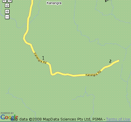
"The Rock", is a huge bolder of granite, so it was a good site as it was about 200 metres north, off the road (grid Sq QF56AA) and well secluded, eventually the National Park Rangers blocked the track to it, back in about 1984 and has become overgrown. It would be hard to find now, but it was the last straight section of road and just prior to the crest that takes you down to the end of the road, (see item "1" on the map) where "The Walls" are situated. It was on the left side of the road driving east towards "The Walls" and there was a large granite rock shelf on the opposite side of the road. Excellent site for VHF/UHF, worked into VK5 on 2m SSB and was heard in VK6, it was quiet RF wise, so good for weak signal DXing. On our last visit to "The Rock" we had to go bush in our cars to avoid the road blockage, by weaving through and between trees to join the old track further into the bush.(entrance at 33.987993 S, 150.064487 E) On one trip, in fact the first trip to that area, we setup at the end of the road near "The Walls", (Grid Sq QF56BA) (see item "2" on the map) but elevation was not as good and lack of seclusion meant we could not run a generator at night, I can still remember operating at night, immersed in low cloud, with visibility of 5 metres with hurricane lamps bleeding into the fog, with unbelievable silence. This was back in the days when NP&WS went out of their way to accomodate people. We were often enshrouded with low cloud on several occassions when operating at "The Rock" as well. The low cloud killed the VHF/UHF, so it often meant doing a bit of DX on HF, ie. 80m, 15m & 10m to pass the time. If you keen to walk and carry your equipment and operate QRP, then walk out along the Kanangra Walls Plateau, once you walk a km or so east it is quite clear and covered in low scrub, excellent takeoff to the city. If go a few kms east you come across these two high knolls, high and clear of trees absolutely excellent. Other places we went to for day trips were Mt Coricudgy,(Grid Sq QF57DD) which is east of Rylstone/Kandos area, a good high spot, accessible by dirt road, flat on top, but heavily shrouded with big trees, you would need to take a large mast to get above the trees (or take a large chainsaw). Other places were Mt. Tomah (Grid Sq QF56FK), Mt. Banks (Grid Sq QF56EK), Mt. York (Grid Sq QF56EK) and several other high spots up in the Blue Mtns west of Sydney, it was not uncommon for us to grab some VHF gear and a yagi and go look for some mountains to conquer. Mt York had good take off to the west and is situated a couple of klms west of Mt Victoria on the Great Western Highway. We would often drive up to Mt.Tomah on a Friday night after work, from Sydney, to do some DX and arrive back home in Sydney well after midnight. Another top site, is out at Shooters Hill (Grid Sq QF46WC), south of Oberon and a also a few good hills near the town of Edith (Grid Sq QF46XE), which is a few klms west of Jenolan Caves. A good, clear site, void of trees is Bald Hill, just a few minutes west of Hill End (Grid Sq QF46QX) Moving forward to 1990's: Another site to visit with some portable gear is Mt Kaputar, which is in northern NSW, between Tamworth and Narrabri, you need to drive to Narrabri to get to it, but from the summit, the view is excellent, you can easily work two hundred kms with just a 2metre handheld radio. You can drive to about 50metres from the summit with a car. The carpark is heavily shrouded with trees, so you must take equipment and walk to the rocky summit. A good location for VHF/UHF/SHF coastal ducting is at Seal Rocks NSW, we camped there in the mid '90's, you need to hike out from the caravan park to get to the lighthouse, from here you have a clean view up and down the NSW coast. In theory it should be easy to work all the way to VK7 on 23cm or even higher bands.Likewise up the coast to VK4. A location I would definitely like to go back and visit again. May 1998: An excellent site I discovered accidentally was driving from Gunnedah to Casino, I think along the Bruxner Highway, it has a teahouse at the top of the hill, accessible by car. (see the photos ) I would like to know the exact location again. More recent trips chronologically (see also the DX Farm web page): May 2007 - visited the lighthouse at Fingal Bay point, known as Shark Island (QG67cg) (Port Stephens) excellent VHF & UHF location, clear view up and down the coast line, accessible by 4WD along the sand spit, but requires permission from NP&WS to get past the gate. (see the photos). Alternative is carry some gear up Mt.Tomaree at Shoal Bay. There is a road, but need permission from Dept of Health to access their site. You can go to the summit from the beach carpark, but have to carry equipment up a lot of stairs. July 2007 - visited Kanangra Walls for bushwalking, I also went looking for and located our old favourite haunt "The Rock" (grid Sq QF56AA) to see what it looked like now, (see the photos) it looked like a bushfire had been through in recent years, so the bushland was quite thin and easy to walk through. Parts of the old roadway leading in were clearly visible. Back along the road towards Jenolan Caves, I found the road to Mt Thett which looks to be a good high point for VHF/UHF and worth investigating in the future. (see the location photos on my Field Photos page on Flickr.com) July 2008 - I drove out south of Edith,(Grid Sq QF46XE) which is south west of Jenolan Caves, the State Forest had been recently cleared east of Shooters Hill, lots of bald hilltops, great for VHF and UHF, being able to park on top of a hill void of trees (see the photos) excellent takeoff and low noise floor, just follow the Shooter's Hill/Goulburn road from Oberon to Edith, or take the Tuglow Caves Road from Edith. Sheepstation Rd (33deg54'20" S, 149deg55'0" E) [QF46wc] this is above 1300mASL you can easily drive off the road and up onto the high point and its all clear of trees, just great for VHF & above bands. Droghedra Rd (near Jaunter) (33deg58'29" S, 149deg53'49" E) [QF4wa] its above 1220mASL the highest point is the road itself, as the road follows a ridge. Better to use the high point off Sheepstation Rd. (see the location photos on my Field Photos page on Flickr.com) July 2009 - tested some locations east and south-east of Edith, it is hard to find an all round high spot, there are high locations, but shielded in certain directions by the Pine plantations, so it comes down to testing from places where the Pine plantations have cleared, this year there were some more locations cleared back near Edith Road between Edith and Porcupine Hill. These look to be most promising for getting and all round take off, including bgetting back into Sydney basin. Obviously, the CAA site (Porcupine Hill) would be the best location, however they have a 300ft tower and unless you had a 300ft tower, you cannot get over the damned Pine trees. One of the other potential high spots is north of Porcupine Hill, this was currently being logged, so we visit in 2010, they may have logged these locations by then. Some locations you really need to have 4WD vehicle, as most of the roads were dirt and very slippery with some moisture. The idea was to look for some places where you can drag a portable mast and a 2m or 70cm yagi up for some portable terrestrial DXing from. I found some great locations above 1300m ASL, but each favoured a particular direction, nothing seemed to provide a good clear omni-directional location.
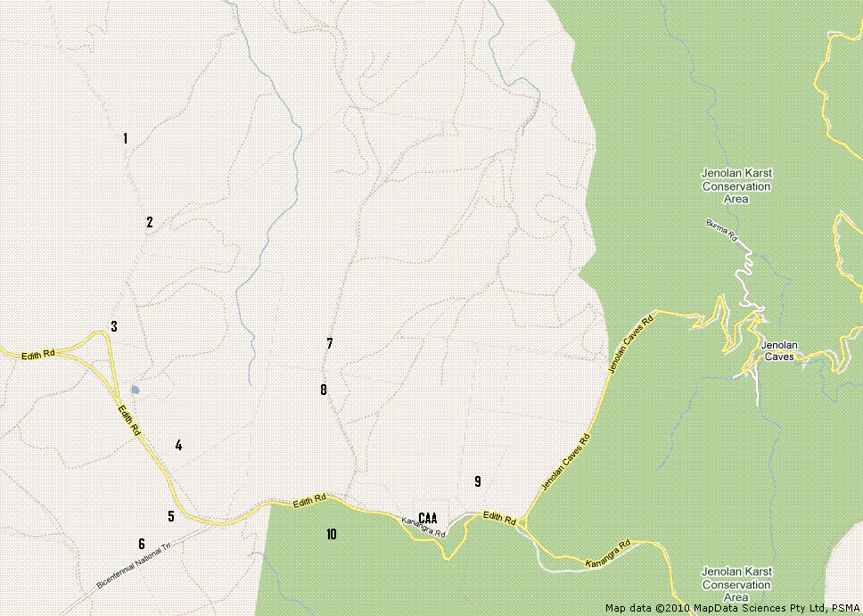
Some locations: (extracted from my blog ) To get to this area, if travelling from Sydney, enter via Jenolan Caves, or via Edith. Site 1. 33.803611 S (33deg48'13"S) 149.961111 E (149deg57'40"E) [QF46xe] - 1300m ASL - further along HorseshoeBend Road, the next high spot. Near Radiata Ridge. Again this shielded to the east by the pine forest. This would have been great 25 years ago for working into VK5 & VK6 on 2m SSB, would have given a clear shot, whereas "The Rock" was obscured by trees. The land here drops away to the Sth and West, so this probably the best location for VHF/UHF takeoff to SthWest and West directions. Well away from power lines here. For sites 1 & 2, the forest boundary follows the Horshoebend Rd, so everything east of Horseshoebend Rd is State Pine Forest. But when the forest is eventually cleared along here, then this will be the best location, as everything west of this road is farmland (grassland), with the little side road at site 1, would be ideal location, once the trees are cleared, giving 360deg clear view for VHF & above bands. This is also the furthest point from the 11kv power lines, that follow Edith Rd. 3 hour drive from Sydney city. Site 2. 33.816389 S (33deg48'59"S) 149.959444 E (149deg57'34"E) [QF46xe] - 1300m ASL - along HorseshoeBend Road heading north from the old section of the Edith Road, farmland on western side, state pine forests on eastern side. Gave good vhf/uhf in a Sth & West directions. Good if you want shielding from the east and NE directions. Will be pretty good location once the pine forest is cleared. Site 3. 33.817222 S (33deg49'02"S) 149.959167 E (149deg57'33"E) [QF46xe] - the intersection, of the old Edith Road and HorseshoeBend Rd, not bad location, but much better travelling north from here along HorseshoeBend Road. This location is close to 11kV power lines. However it is currently clear of trees. I noticed a few blocks of land for sale here. Site 4. 33.827222 S (33deg49'38"S) 149.963333 E (149deg57'48"E) [QF46xe] - 1340m ASL - part of the State Pine forest of Edith Road, now cleared. Nice and high and flat, but close to the main road. The downside is the 11kV power lines running along the road, creating RFI. You can look across the valley to locations 7 & 8. Site 5. a clear spot on the side of the road, but close to the 11kv power lines and noisy on HF, plus road noise, but it is high and clear. Site 6. 33.838333 S (33deg50'18"S) 149.956944 E (149deg57'25"E) [QF46xd] - 1340m ASL - part ofthe State Pine Forest, off the Bicentennial National Trail, between Ginkin Road and Edith Road. The forest has now been cleared. good takeoff to the S.W & West & Nth directions.The ground slopes away steepy to the west, probably the location with best takeoff for VHF/UHF towards VK5 & VK6. Very shielded by forests to East, SE & Sth directions Site 7. 33.816111 S (33deg48'58"S) 149.980556 E (149deg58'50"E) - 1320m ASL - this is a ridge north of the Edith Road in the State Pine forest, this spot is currently covered in forest, but is also currently being logged, being a ridge it should have excellent coverage both east & west, I think by this time next year (2011), it will have been cleared to be able to perform some tests. I think this location is most promising in the future (or at least until the next generation of Pine trees grow). A good distance from the 11kV power lines on Edith rd. Site 8. on the same road as site 8, its the other peak, it is still heavily forested, there is alot of forest to the sth which is higher, heading towards site 10. Site 9. 33.830556 S (33deg49'50"S) 149.993333 (149deg59'36"E) [QF46xe] - 1320m ASL - off Kanangra Road, just north of the CAA site. Good takeoff to the Nth East - East - Sth East (Sydney), but nothing to the west. However, you sitting under the shadow of the CAA comms tower. Come down the hill to the east you encounter the cabins, from here VHF/UHF back to Sydney is very easy, not good for HF, as the 11kv lines runs through the cabins. Site10. The highest point in this area is at 33.832222 S (33deg49'56"S), 149.983611 E (149deg59'1"E) [QF46ex], above 1360m ASL just west of the CAA tower on Kanangra Road, but even though it is the highest point, it is heavily covered with forest and is quite useless. Just have to wait until that section of pine forest is cleared. This is about the same height as Mt Bindo. (see the location photos on my Field Photos page on Flickr.com) In the future when it is all cleared it would be good location, although the 11kv power lines run along the road here. I also looked at some locations out in Kanangra Boyd National Park, Thurat Tops has good high spots, accessible by fire trails only using 4WD. Did not get there, but probably too heavily wooded. (I don't think NP&WS would allow tree clearing here) But a good location that is open and clear is on the Kanangra Road about 5kms back from "The Walls" (see photos on Flickr) at 33.989444 S (33deg59'22"S) 150.070278 E (150deg4'13"E) [QF56AA] (almost 1220m ASL) excellent takeoff to the nth east, east & sth east directions. Not as high as "The Rock", but it is clear of high trees, see map below.
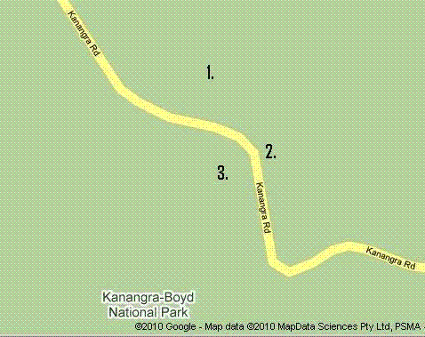
1. is "The Rock" if you have 4WD, you can bush-bash in making your own entrance to get to the old track. The old entrance is located at 33.987993 S, (33deg59'17") 150.064487 E (150deg3'52"E) [QF56aa] Also, on the southern side of this road, if you venture into the bush about 10-20m off the road, you can find some large rock shelves, they are big enough to park a few cars on, if you have some ingenuity, you could get a couple 4WD's up onto the rock shelves and park and operate from these rock shelves. 2. on the rock shelf, you could easily drive up onto the rock shelf with a 4WD, but you can not camp here, as it very open view from the road. 33.989444 S (33deg59'22"S) 150.070278 E (150deg4'13"E) 3. drive off road behind the bushes, with a 4WD, enter from the Jenolan side, there are some large rocks, you can put up a mast and be out of view of the road (and the NP&WS Rangers). This is just along from here to the east from "The Rock", it has another large rock, (shown on my photos page), you would have to bush-bash to get off the road out of view to put up some antennas 33.989808 S (33deg59'25"S), 150.06968 E (150deg4'7"E) [QF56aa] The scrub is low, with no large trees, so not hard to get a mast up above the scrub. This would be ideal for microwave DXing back into Sydney, or north coast or south coast, maybe VK1 & VK3 direction too. July 2010 - visited the Porcupine Hill/Edith area again (QF46xe) did some more site checks, note that one of the potential new sites in the Pine forest has now been cleared of its Pine trees. I took photos to show this. Also went to Bathurst via Oberon & O'Connell found a few reasonably high spots and a few nice looking farm properties. The lookout at Oberon is located at (33deg42'11"S) (149deg50'42"E) [QF46wh] about 1160m ASL, this is great, clear of trees in all directions, but a large RF comms tower on site. compared to Mt Bindo (33deg40'69"S) (150deg0'58"E) [QF56ah] at above 1340mASL. Mt. Panorama at Bathurst is located at (33deg27'40"S) (149deg33'64"E) [QF46sn] at approx 880mASL, you can move around to differnent access points on this small plateau to get a clear takeoff in any direction, but still the site is populated with several RF towers, which makes it RF noisy. March 2018 - operated John Moyle Field Day contest from QF56cm location (1175m ASL), but not getting the results I was after, so packed up and relocated to Mt.Lambie QF46xm (1300m ASL). On the way to Clarence, I detoured in and stopped into Mt.Tomah, down near the microwave tower, unfortunately, Mt.Tomah is shrouded with large trees and totally useless for VHF and above.
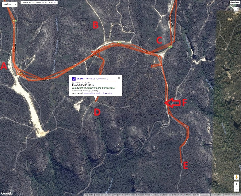
satellite map of Clarence area (QF56cm) - (March, 2018)
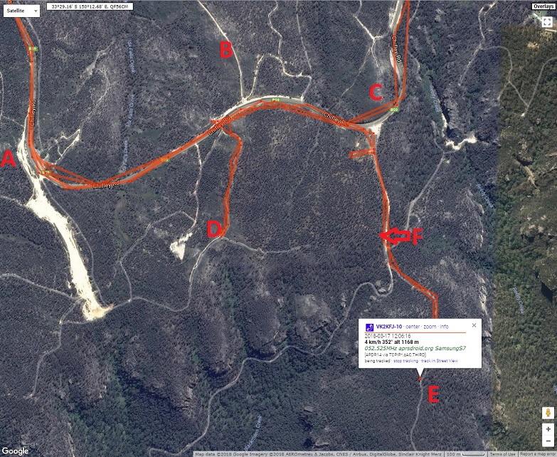
site A - I had operated here for a 23on23 microwave day in 2017, it was accessible then, but not now, it has large concrete barriers to keep cars out and warning signs that it is private property
site B - looked promising, quite clear of trees, but not as high as hoped for.
site C - looked very promising from the road, but couldnt quite figure how to get to the site.
site E - driving around dirt tracks, came up to this, found a large concrete slab, something had been here a long time ago, but now very heavily wooded, but it is 1168m ASL
Location F - this is a pointer to a alternate dirt track to Site D
satellite map of Clarence (NSW) area (QF56cm) - (March, 2018)
site D where I operated from for first part of John Moyle Field Day contest. It is relatively clear site, predominantly very low scrub, next door to private property which is to the west of this site, I could see survey markers, so maybe new owners planning to erect a fence, stay near track to be safe. It is 1175m ASL, it has clear LOS to Hartley, Mt.Victoria, Blackheath, Katoomba, Megalong Valley, Kanangra Walls, Campbelltown, Illawarra Looking the other way, it clear horizon west, through N.W. to north. North through to East is blocked by trees, Dural beacons were just audible. The track in from Chifley Rd is definitely for 4WD. You will need to use the track from the east for something less than 4WD. If you need to work towards Mid nth coast, or Central Coast, then best to go to Newnes/Dargan up near the railway line, it has great take off to N.E. direction. photos at Clarence QF56cm
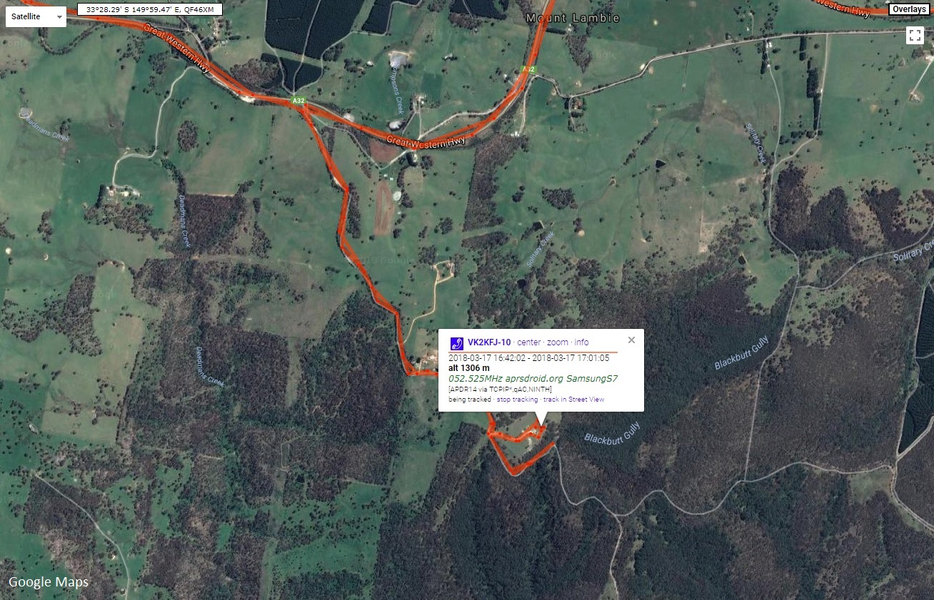
satellite map of Mt.Lambie (NSW) area (QF46xm) - March 2018 Access by dirt road, 4WD preferred, but not essential, unless raining. it is a great site. Hearing repeaters from Somersby to Illawarra and pretty much 360 degree view. photos at Mt.Lambie QF46xm
July 2018 - did some extensive potential site exploration around Edith, NSW (QF46xe) in vicinity of Horseshoebend Rd, (1300m ASL) some of the sites I visited 8 years ago are now overgrown by pine forest and other places that were covered in pine forest are now cleared. I also did some tests from the Fire Tower at Shooters Hill (QF46wc) from the ground level it is pretty useless and surrounded by fully grown pine trees, however, the good news is this will most likely be cleared in 2019 as I spotted nearby areas that have been recently cleared. The advantage for Shooters Hill is that it is clear towards Sydney-Wollongong, I had no trouble hearing and working 6m,2m and 70cm repeaters down on the coast, plus a slot towards Canberra, once they clear the forest surrounding fire tower, then this will be a great location for VHF and above activity. In my early maps, I mentioned site 1, Horseshoebend Rd, as mentioned this is now cleared with new pine saplings so it will be come overgrown in a few years, but had a play with 23cm from here, Dural 23cm beacon easily heard, so no problem getting into sydney with microwave equipment. I also did some extensive poking around the Kanangra-Boyd National Park, trying out all accessible 4WD tracks looking for accessible high places that are clear of trees for microwave activity, unfortunately, not that many clear locations, plenty high spots, but usually heavily wooded with damned gum (eucalyptus) trees. Most of the mountains have tracks, but heavily fortified by the NPWS, so the only way up to a mountain top is on foot. I did find a good spot to the south-west side of Kanangra-Boyd, on Boyd river loop road, came to a end of a plateau where the road drops into the valley with large granite outcrops with perfect view to the horizon of south through to west. Great for VHF and above towards VK1 and VK3 and quite clear of trees due to the amount of granite outcrops. Found secluded off road parking here and plenty of rock crevaces for antenna masts. I could see Shooters Hill tower from here clearly. One interesting place was back near the start of the Kanangra rd, it is a side track leading to a private property (within the national park) just a few hundred metres off the main road found a high spot, flat, sparsely vegetated, easily driven into with a car, fine for HF, difficult for VHF and above but potentially good if there were no trees, good for camping too. Referring back to my map for 2009, sites 4,5,6 totally overgrown in 9 years, sites 1,2,7,8 now all cleared. Site 10 is Mt.Trickett, is thinned but growing back. Site 1 is definitely best for microwave activity at the moment. If drive north of site 7 it is all cleared, this high ridge can be easily seen from site 1. and with reference to my "The Rock" map of 2008, I visited this again while checking out Kanangra- Boyd, location 2 & 3 near The Rock are now overgrown after 10 years. You could carr some microwave gear up onto the rock shelf at location 3 to get some easterly takeoff, its very resticted now. January 2019 - operated WIA Summer VHF-UHF Contest from Mt Lambie QF46xm (1300m ASL) got some good results. Worked stations in Sydney, Central Coast, Illawarra and Canberra regions. Then went across to QF46pu to do some more contest operation on SHF and did some survey work for a possible VHF/UHF WSPR and SHF beacon site that we thinking about setting up. photos at Mt.Lambie QF46xm