V73NS
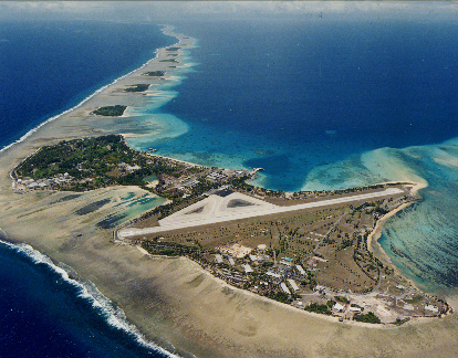
Kwajalein
Atoll - Marshall Islands
on the island of
 Roi-Namur
9°
23' 47" N
167° 28' 30" E
IOTA OC-028 (Ralik Chain)
Grid Square RJ39

|
I am living and
working on Roi-Namur, the northern most island of Kwajalein Atoll. Kwajalein consists of a group of 90 coral islets that surround the third largest lagoon in the world. The TOTAL land area is 6.2 square miles and the atoll is 78 miles in length. The islets of Kwajalein and Roi-Namur were the first of the Marshall Islands captured by U.S. troops in WWII. The atoll serves as a seaport, air stop and U.S. military missile testing site. |

Click the above map to open a detailed map
| The Marshall Islands first emerged 70 million years ago when volcanic cores erupted at presently extinct hotspots south of the equator. Around 40 million years ago, while the Pacific plate continued to move in a northwesterly direction, the volcanoes began to subside. The islands were initially high, volcanic islands, but over the course of the ensuing 40 million years, they slowly sank back into the ocean from which they came, propelled by their own weight. Microscopic organisms called polyps, which thrive in warm waters with high salinity, salvaged the remaining rim of what was once a volcano to the extent that, with botanical seeds transported by birds and ocean currents, 3,000 years ago small islets had taken form on the reefs, capable of sustaining life. These islets formed circular rings encircling sheltered lagoons. |
(looking to the south)
Roi-Namur...
The "Dot in the Pacific"
2,136 Miles SW of Honolulu

Current Pacific Weather
Kwajalein Atoll in the center


Click the above map to open a detailed map
Global Location
of Marshall Islands
Sitting on
the other side of the dateline, it is already tomorrow there!
+12 Hours from
GMT
Pre-20th-Century HistoryThe first Micronesian navigators arrived in the Marshall Islands sometime between 500 and 2000 BC. Little is known of their origin or culture. The Marshalls were never united under a single leader, though one chief often controlled several atolls and at times an entire chain. Before the arrival of Europeans, the individual chiefs held absolute authority over their lands, and - living on such narrow stretches of land - their claims to their parcels were often hotly contested. The 1494 Treaty of Tordesillas ceded ownership of all of Micronesia to Spain. The Marshalls, however, were off the main trade routes and consequently received little attention from early European explorers. In 1525, Alonso de Salazar of Spain became the first European to sight the islands, but Spain did nothing to colonise them. After another 200 years devoid of Europeans, the islands received a visit from English captain John Marshall (from whom they later took their name) in 1788. Russian explorer Otto von Kotzebue came through in the early 1800s and drew the first detailed maps of the islands. Traders and whalers began to visit the islands en masse in the early 1800s, until encounters with the 'friendly' native Marshallese began to turn sour. Ship after ship putting into port at various atolls in the Marshalls quickly weighed anchor after the death of their captain or crew members. Violence was on the decline when the first Protestant missionaries arrived in 1857, setting up churches and schools and gradually undermining the traditional authority of the island chiefs. Modern HistoryGermany annexed the Marshalls in 1885 but didn't place government officials on the islands until 1906, leaving island affairs to a group of powerful German trading companies. Japan took over in 1914 and colonised the Marshalls extensively, developing and fortifying large bases on many of the islands. The first Micronesian islands captured by the Americans in WWII were at Kwajalein Atoll in 1944. Majuro Atoll was taken next and quickly developed into a base for aircraft carriers. Within weeks some 30 other islands had fallen. After the war, the Americans immediately began to test atomic bombs on Bikini and Enewetok atolls. (Kwajalein was later established as a missile testing site.) Chief Juda of Bikini was convinced to move his people - for the 'benefit of mankind' - to Rongerik Atoll, on the understanding that they'd be able to return to their homeland after the tests were over. A few months later, the USA exploded the first of the 23 nuclear devices that were to be detonated at the atoll. (Between 1946 and 1958 the United States tested 66 nuclear weapons in the Marshall Islands, including the largest nuclear test the United States ever conducted, Castle Bravo.) The Bikinians nearly starved from inadequate food supplies on Rongerik, and two years later they were moved to Kwajalein Atoll and then to Kili Island. In the 1970s, they were told it was safe to return to Bikini, where they found two whole islands entirely blown away and most of the others treeless. Nevertheless, they stayed, and within a few years they were found to have dangerous levels of radiation in their bodies and were moved off the island again. In 1973 the Marshall Islands boldly withdrew from the Congress of Micronesia, seeking political independence. The move worked and, in 1979, the Marshalls' constitution became effective. In 1986 the Compact of Free Association with the United States entered into force, granting the Republic of the Marshall Islands (RMI) its sovereignty. The Compact provided for aid and U.S. defense of the islands in exchange for continued U.S. military use of the missile testing range at Kwajalein Atoll. The independence was formally completed under international law in 1990, when the UN officially ended the Trusteeship status. Admission to the United Nations was achieved in 1991. Recent HistoryToday, scientists from California's Lawrence Livermore Laboratory are using Bikini as a case study in ways to clean up radiation. So far, they've had some success with using potassium fertilizer to block the uptake of cesium in plants, but there are still long-term problems with eating anything grown on the island. Ironically, as the Bikini cleanup continues, the Marshallese government is considering the atoll as a possible dump site for commercial radioactive waste material produced by Asian and North American power plants. Meanwhile, the Marshalls were heavily hit by the effects of variations of the El Nino weather pattern in 1997 and 1998, receiving almost no rainfall. Drought affected most of the country's population, particularly on Majuro and Ebeye. The country seems set to remain dependent on US subsidies for the indefinite future. In December 2003 the two countries signed a Compact of Free Association, in which the Marshalls effectively became a US protectorate in exchange for payment of US$3,500,000,000.00 over 20 years. Meanwhile, it seems unlikely that Bikinians will receive the compensation awarded to them in 2001 by the Nuclear Claims Tribunal for the US atom-bomb tests that devastated their islands for many years. |

This is where
I work...
No, they won't
let me use it for EME contacts. HI HI
![]()

Kwaj
Bike
(this bike frame desolved into scrap June 2003)
| Out here
we ride bicycles to work, as there are no private cars. Being located
on a small island, you never have very far to ride. Salt eats everything
so a fancy 18 speed mountain bike is reduced in short order to a single
speed when the salt consumes the cables. The primary mode of transportation
is the "Kwaj Bike". Typically a standard single speed bike, more often than not a ladies frame since a basket is mounted on them and you get tired of swinging your leg over. This is not a macho fashion show of two wheeled status... it is transportation! Things here don't rust... they DESOLVE! |
Last updated 29 May 2014