|
| HISTORY OF SISKIYOU COUNTY, CALIFORNIA |
| Pages in the RED MENU are text only. |
|
Mount Shasta |
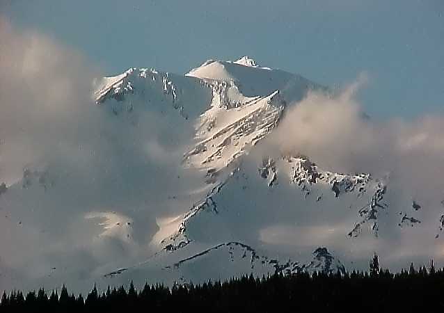 |
Mount Shasta |
 |
This is an old print (source unknown). Very unlikely it is
legitimate. |
From: History of Siskiyou County, California, Published 1881 Among the towering ranges are many places of grandeur that deserve a
special mention, and one, Mount Shasta, of world-wide fame and notoriety. |
Compiled From: Smithsonian Institution -
Global Volcanism Program, Wright and Pierson, 1992, Living With Volcanoes, The
U.S.Geological Survey's Volcano Hazards Program: USGS Circular 1073, Foxworthy and Hill,
1982, Volcanic Eruptions of 1980 at Mount St. Helens, The First 100 Days: USGS
Professional Paper 1249 and U.S.Census Bureau
|
From: Wood and Kienle, 1990, Volcanoes of North America: United States and Canada:
Cambridge University Press, 354p., p.214-216, Contribution by Robert L. Christiansen
|
AbstractMount Shasta has erupted, on the average, at least once per 800 years during the last 10,000 years, and about once per 600 years during the last 4,500 years. The last known eruption occurred about 200 radiocarbon years ago. Eruptions during the last 10,000 years produced lava flows and domes on and around the flanks of Mount Shasta, and pyroclastic flows from summit and flank vents extended as far as 20 kilometers from the summit. Most of these eruptions also produced large mudflows, many of which reached more than several tens of kilometers from Mount Shasta. Future eruptions like those of the past could endanger the communities of Weed, Mount Shasta, McCloud, and Dunsmuir, located at or near the base of Mount Shasta. Such eruptions will most likely produce deposits of lithic ash, lava flows, domes, and pyroclastic flows. Lava flows and pyroclastic flows may affect low-and flat-lying ground almost anywhere within about 20 kilometers of the summit of Mount Shasta, and mudflows may cover valley floors and other low areas as much as several tens of kilometers from the volcano. On the basis of its past behavior, Mount Shasta is not likely to erupt large volumes of pumiceous ash in the future; areas subject to the greatest risk from air-fall tephra are located mainly east and within about 50 kilometers of the summit of the volcano. The degree of risk from air-fall tephra decreases progressively as the distance from the volcano increases |
| The Legends of Mount
Shasta February 23, 2004
Towering in isolation above the surrounding landscape, Mount Shasta is a mountain shrouded in mystery and the unexplained. To many, the area around Mount Shasta is one of the most mystical in all the world and people come from far away to live in the mountain’s shadow. With stories of underground cities, flying saucers, unexplained lights and encounters with unusual beings, it would be hard to envision a place with more mystique than Mount Shasta. Along the drive from Los Angeles to Canada and back again, my trip would take me past Mount Shasta twice. On the first leg of the trip, traveling north, the weather was cold and wet as expected. As we stopped for gas in the small town of Weed, I opened the car door to howling winds and a mountain peak completely obscured by clouds and fog. This was not the view I had hoped for. It would be a week before I would get another chance to see Mount Shasta and I used that time to learn more about the legends surrounding this mysterious mountain. Part of the Cascade Range, Mount Shasta rises to a height of over 14,000 feet. Unlike other peaks that blend into the surrounding mountains, Shasta stands alone, rising above what seems to be an almost flat landscape by comparison. It is in part this solitude that Mount Shasta represents that gives the mountain its mysterious aura. The area around Mount Shasta has served as the home to several Native American tribes for thousands of years. However, it was not until the early 19th century that the first Europeans laid eyes on it. The Spaniards named the mountain “Jesus-Maria” when they passed by it in 1817. The Russians gave it the name of “Tchastal,” meaning white or pure mountain. 1 Some believe that Tchastal was interpreted as Chasta by early Americans and later the name became Shasta. Historian Stephen Powers on the other hand believes the mountain was named for the Shas-ti-ka Indians. It seems even the name Mount Shasta is derived from mysterious origins.
Like the more famous Atlantis, Lemuria was said to be the site of a vast and wonderful society that rose to great social and technological prominence in ancient times. While Atlantis was said to lie in the Atlantic Ocean, Lemuria was found in the Pacific. James Churchward in his many writings, claimed the continent was so large it stretched all the way from Australia to California covering the majority of the Pacific Ocean in one great land mass. Modern day science has all but eliminated the possibility of such a large continent existing within the past 10,000 years, but it is possible that a much smaller landmass could have existed in the Pacific and that the legends of Lemuria may not be based entirely on wishful thinking or fanciful speculation. 2 Proof of a Lemurian city appeared to come from astronomer Dr. Edgar Lucian Larkin, former director of the Mount Lowe observatory, who wrote extensively about Mount Shasta in the San Francisco Examiner. One day, while testing a new telescope, he directed its lens towards the base of the mountain. Instead of seeing only treetops as he expected, he spied a golden dome that appeared to be of Asian construction. As he continued to monitor the site, he eventually made out two additional domes and then another building apparently made of marble. As the sun descended and night fell, Dr. Larkin was shocked to see the area illuminated by a bright white light even though there was no moon visible that evening. 3 Unfortunately, these sightings were never independently verified and many now believe the whole story was a hoax. But a lack of hard evidence hasn’t stopped interested hikers and explorers from searching the mountain. While no one has come forward claiming to have found the golden domes supposedly witnessed by Dr. Larkin, others have returned to tell strange tales that are no less fantastic. In 1904, a prospector by the name of J.C. Brown was hired by the Lord Cowdray Mining Company to prospect for gold in the Sierra Nevada Range. On his second prospecting trip, Brown stumbled upon a man-made tunnel carved into the solid rock near Mount Shasta. He followed the tunnel and eventually arrived in a large cavern lined with sheets of copper. Golden shields adorned the walls and he found artifacts and statues as well. Adjoining chambers were filled with strange drawings and undecipherable hieroglyphics. Another chamber held the bones of what appeared to be giants. As so often happens with discoveries of this kind, Brown reported what he had discovered to no one, fearing his employers would lay claim to his discovery. Instead, he waited patiently for 30 years until his retirement. At that point, he told his tale and put together a group to follow him back to the site to search for the tunnel. In June of 1934, 80 people eagerly anticipated the following day when Brown was to have revealed the location of the tunnel. But sometime in the night, he mysteriously disappeared and was never heard from again. The Stockton police investigated the incident and came to the conclusion that Brown was probably kidnapped. Without Brown to serve as a guide, the tunnel and all its treasure have supposedly never been rediscovered. 4
The Lemurians are not the only mysterious beings rumored to inhabit the slopes of Mount Shasta. In the Spring, 1953 edition of the Siskiyou Pioneer, Marcelle Masson related a legend from the Wintun Indians concerning a race of fierce giants inhabiting the caves around the mountain. On the other end of the size spectrum are the legends of the “Little People” that have been seen around the strange geological formations known as the Siskiyou Stone Circles. 5 In recent times, Mount Shasta has been the site of numerous sightings of unexplained lights and UFOs. In “’Now I can See!’ – Miracle on Mt. Shasta,” Hanna Spitzer relates her own encounter with a bright white light that quickly glided past her trailer, illuminating it “brighter than the light of day.” The next morning, Spitzer awoke to find that she no longer needed the glasses she had worn since childhood. Remarkably, her vision was healed. The incredible stories and numerous legends had piqued my interest in Mount Shasta and I couldn’t wait for the return trip. Driving south, the sky was clear and the weather was beautiful. I could see the distant peak of Mount Shasta from miles away. As we rounded the mountain on its western side, we exited the freeway to spend some time exploring the small town of Mount Shasta. I took every opportunity to photograph the mountain while the sky was clear. In the winter, you never know when the weather will change and the clouds will move in again.
Many of the stories relating to Mount Shasta seem too fantastic to believe and
admittedly the hard evidence to back them up is all too often lacking. Still, the sheer
volume of reports seems to point to the inescapable conclusion that there is something
unusual about this area that warrants further investigation. Further Reading: The Mt. Shasta Story Mount Shasta, Home of the Ancients Lost
Cities of North & Central America
Sources: 1) Eichorn, Arthur. The Mt. Shasta Story (Mount Shasta Herald, 1957). 2) Churchward, James. The Lost Continent of Mu (Ives Washburn, 1931). 3) Cerv�, Wishar. Lemuria—The Lost Continent of the Pacific & The Mystery People of Mount Shasta (The Rosicrucian Press, 1931). 4) Walton, Bruce. Mount Shasta, Home of the Ancients (Health Research, 1985). 5) Noble, Johnny. The Mysterious Circles of Shasta (FATE Magazine, Nov-Dec 1951). |
|

 Of all the legends surrounding the mountain, the most
famous is that of the Lemurians who are said to dwell within it. Refugees from the sunken
continent of Lemuria or Mu, the Lemurians are described as tall, handsome and beautiful.
Dressed in white robes and sandals they supposedly would come down to the small town of
Mount Shasta and trade gold nuggets for supplies. Of course, they don’t seem to come
to town anymore and it is rumored that the Lemurians have moved out of Mount Shasta,
choosing to relocate to a less publicized location such as the Himalayas.
Of all the legends surrounding the mountain, the most
famous is that of the Lemurians who are said to dwell within it. Refugees from the sunken
continent of Lemuria or Mu, the Lemurians are described as tall, handsome and beautiful.
Dressed in white robes and sandals they supposedly would come down to the small town of
Mount Shasta and trade gold nuggets for supplies. Of course, they don’t seem to come
to town anymore and it is rumored that the Lemurians have moved out of Mount Shasta,
choosing to relocate to a less publicized location such as the Himalayas.
 After parking next to the police station, I spent an
hour walking around town and exploring the many small stores. It seemed that about half of
the shops catered to a New Age crowd with books on spirituality and crystals found in
abundance. After I satisfied my curiosity by sampling many of the local establishments, we
drove up the road to get a closer look at the mountain, before eventually returning to the
freeway. I wish I could have spent more time in the area, but any real exploration of the
mountain would demand more consistent weather than winter offers.
After parking next to the police station, I spent an
hour walking around town and exploring the many small stores. It seemed that about half of
the shops catered to a New Age crowd with books on spirituality and crystals found in
abundance. After I satisfied my curiosity by sampling many of the local establishments, we
drove up the road to get a closer look at the mountain, before eventually returning to the
freeway. I wish I could have spent more time in the area, but any real exploration of the
mountain would demand more consistent weather than winter offers.