|
G3VGR
|
ALBSTEIG Niedermühle - Albbruck
|
 My original plan, as recommended by the "Albsteig Connoisseur" tour, was to walk from Niedermühle to Albbruck over 2 days, breaking the hike at Görwihl .
However, the transport connections to Görwihl are infrequent which would require me to catch a train at 0500 with a 4 hour journey to get there at a reasonable time to start the fifth stage.
The next possible connection would result in me arriving in Görwihl around midday, so neither option was desirable.
Also the walk from Niedermühle to Görwihl is quite short (9Km) and I would spend more time commuting than actually hiking the fourth stage.
To resolve these dilemmas, I concluded the best solution would be to walk both stages in one day.
The 7323 Bus arrives in Niedermühle at 0735, which would allow me plenty of time to make the day's 19Km walk, including allowing for extended time spent photographing in the Höllbachschlucht.
My original plan, as recommended by the "Albsteig Connoisseur" tour, was to walk from Niedermühle to Albbruck over 2 days, breaking the hike at Görwihl .
However, the transport connections to Görwihl are infrequent which would require me to catch a train at 0500 with a 4 hour journey to get there at a reasonable time to start the fifth stage.
The next possible connection would result in me arriving in Görwihl around midday, so neither option was desirable.
Also the walk from Niedermühle to Görwihl is quite short (9Km) and I would spend more time commuting than actually hiking the fourth stage.
To resolve these dilemmas, I concluded the best solution would be to walk both stages in one day.
The 7323 Bus arrives in Niedermühle at 0735, which would allow me plenty of time to make the day's 19Km walk, including allowing for extended time spent photographing in the Höllbachschlucht.
There had been a heavy thunderstorm during the night and today was forecast to be cooler with outbreaks of rain, so I elected to wear hiking trousers instead of my usual shorts and also packed my raingear.
I made another early start by catching the 6AM train from Hinterzarten to arrive at the trailhead at 0725.
After crossing the road at the Niedermühle bus stop, I found the first Albsteig sign which started me on a narrow path running above and alongside the L154 road from Niedermühle.
The path was quite narrow and the undergrowth was quite high and still wet from the night's storm, so wearing hiking trousers today had proved to be the correct decision.
I really enjoy walking through forests after a heavy rainfall and savoured the smells of the wet foliage.
The path ended at the Albtalstrasse and I crossed at the Alb over the Wilfingersteg then continued through jungle-like vegetation until reaching a turnoff to the first viewpoint of the day.
The short branch from the main trail brought me to a rest area situated on a rock pulpit overlooking the Teufelsküche.
From the viewpoint are glimpses of the 100 meter long bottleneck in the Alb river bed which was formed by a glacier in the last Ice Age.
During the snowmelt or after heavy rains, a vortex forms here and the fast flowing water rages and surges through the many swirl holes.
This maelstrom gave this place the name "Teufelsküche" (Devil's Kitchen).
Unfortunately, trees obscured much of the views and it's not feasible to climb down to the river bed from the viewpoint through the surrounding rocks.
Apparently, it is possible to descend from the other side of the Alb, but to approach the access point entails a long walk along the L154 road.
However, I read that the road has been closed to both traffic and pedestrians since 2015, although the descent to the river seems to be hazardous.
As I was hiking alone, this excursion seemed too dangerous to contemplate, so I contented myself with the available views of today's first highlight.
Leaving the viewpoint, the path led me along a wide,natural forest path through the Hotzenwald.
I reached a small road, which I followed 100 meters to the right before arriving at a wooden bridge (Ibach-Steg) over the Ibach.
The road had been closed to traffic and men were working clearing the river bed.
From the other side of the bridge, the Albsteig continued uphill along a wide forest road (the Burgenhaldenweg) until reaching a junction at the main signpost for Hornstollen, where the path to Görwihl branches off from the Albsteig.
I took the left fork to enter the Höllbachschlucht, which had impressed me so much on my 2019 visit to the Hotzenwald.
The Schwarzwald has an excellent collection of ravines and the Höllbachschlucht is one of the best with its steep rocky downhill path along the noisy, tumbling Höllbach stream.
Everything is so green with much moss covering boulders and tree trunks. I passed the two main waterfalls and a few cascades on my way down the trail.
After reaching the bottom of the ravine where the Höllbach flows into the Alb, the trail went steeply back uphill on a forest road passing the Albsteg and various cascades that tumbkled down the hillside.
I continued along the road for a while until a sign diverted me from the forest road to the Kaibenfelsen, a large rock formation, deep in the forest, which provides a viewpoint over Görwihl and the surrounding area
I rejoined the forest road and carried on my way. By now, I was getting rather fed up with interminable forest roads and was glad when I reached the end at the L153 road.
Opposite me was the Gasthaus zum Löwen, a rather nice country restaurant.
I sat on their terrace and enjoyed a glass of Hefeweizen. I could have stayed all day but had more miles to walk.
Despite my dislike of the semingly endless forest roads I'd tramped along this morning, they were definitely a better experience than what confronted me next.
The way ahead was along the side of the busy L153 road with many cars and trucks passing closely.
I reached the village of Tiefenstein and was then able to walk along a pedestrian pavement which made me feel safer.
The Alb valley is a narrow gorge around Tiefenstein, so I suppose there was no alternative to the current urban route.
After crossing a bridge over the Alb, matters improved considerably. The Albsteig took a narrow path away from the road and climbed steeply to the top of the gorge, where it became a narrow ridge walk.
This was excellent hiking at last. I reached a viewpoint named Bernhardt's Ruhe which gave views across the gorge to the Tiefensteiner Granitwerk, an ugly granite quarry.
There was a bench set into the rockface and I sat there and ate my lunch enjoying the views along the Albtal.
I carried on along the narrow ridge path to Peterskanzel, a 473m high viewpoint. There were great views of the gorge from here, although I couldn't see the river below due to the mass of foliage on the sides of the gorge.
This is a really wild, unspoilt area and I was enjoying the experience.
The ridge walk ended at the village of Hohenfels and I was about to get my daily ration of a rough steep descent.
An almost vertical rocky path took me via sepentines down to the Studinger Steg, a footbridge over the Alb.
As I reached the bridge it started to rain, but by the time I donned my waterproofs and put on my pack cover, it stopped and that was the only rain of the day, despite the day's forecast.
From the Studinger Steg I had views into the wildest part of the Alb. Forces of nature have spawned huge boulders into the gorge over the years, making this lower course of the Alb one of the most difficult whitewater stretches in Germany for kayakers.
I made a steep ascent up more serpentines to reach the top of the west side of the gorge and was soon out into open countryside.
It felt almost a reief to be out in wide open spaces after the confines of forests all day and I now felt quite exhausted after crossing the Albtal gorge.
A tarmac road took me past fields of maize towards Schachen.
A herd of Chamois is resident in the area around Schachen, but despite continually scanning the area, I didn't see any.
The only wildlife I had seen all day was a solitary toad near the Studinger Steg.
Now heading southwards, I had fine views over the Rhein Valley and Switzerland and could now clearly see the plume of water vapour rising across the Rhein from the cooling tower of the Leibstadt Nuclear Power station, the most powerful reactor in Switzerland.
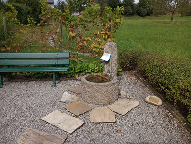
I stopped at the Schachen Brunnen, the other water fountain of the Albsteig and rested my feet, which had been battered again during the descent to the Studinger Steg.
After changing to a clean pair of socks and consuming large quantities of water, I was ready to finish my hike.
The trail continued between the farm fields always downhill until reaching some woods. Another rough descent and corresponding ascent was the last challenge of the day.
before I was walking down an easy forest path which ended at the Alte Landstrasse.
Continuing along the pavement of the Alte Landstrasse into Albbruck, I crossed over the Alb for the last time and then along Bahnhofstrasse until reaching the large Albsteig portal at the railway station where the trail ended.
From the portal, I crossed the railway tracks via a pedestrian bridge to shop in an Edeka store.
I noticed a pub opposite Edeka and decided that I had earned some celebratory beers.
Sitting in the biergarten of the Bier-Börse with a few glasses of Hefeweizen and a Rösti was a pleasant way to celebrate completion of the Albsteig.
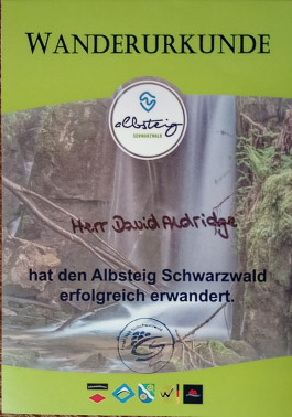
Next morning, I visited the Tourist Office in Bernau-Innerlehen, where I presented my completed Wanderpass and received a certificate and some free souvenirs of the Albsteig.

Way to Teufelsküche
|

Beautiful woodland flowers
|

Teufelsküche
|

Teufelsküche
|

Rejoining the Albsteig from Teufelsküche
|

Ibach Steg
|

Along the Burgenhaldenweg
|

Rest spot before the Høllbachschlucht
|

In the Höllbachschlucht
|

Höllbach Wasserfall
|

Confluence of Höllbach and Alb
|

Bridge over the Höllbach
|

Albsteg
|

Cascade
|

Kaibenfelsen
|

Gasthaus zum Löwen
|

Along the road to Tiefenstein
|

The Alb at Tiefenstein
|

Ridge walk above Albtal
|

Ridge walk above Albtal
|

Tiefenstein Granitwerk
|

View from Bernhardt's Ruhe
|

Peterkanzel
|

Albtal view from Peterkanzel
|

Albtal view from Hohenfels
|

Studinger Steg
|

View upstream from Studinger Steg
|

View downstream from Studinger Steg
|

Out of the forest into Schachener Feld
|

The route to Schachen
|
Schachen Brunnen
|

Through the cornfields to Albbruck
|
|
|
|

Crossing the Alb in Albbruck
|

At the Albsteig Portal - Albbruck
|