Cathedral
Peak – the highest SOTA activation yet!
By Andrew Roos ZS1AN
Following
our wedding on 9th August 2003, Stacey ZR1SC and I went on honeymoon
to the Drakensberg Mountains where we stayed at the Cathedral Peak Hotel, which
nestles amongst the foothills of some of the most spectacular mountains in the
South Africa: Cathedral Peak, The Bell, the Outer and Inner Horns, the Mitre
and Cathkin Peak. Knowing of my interest in the Summits
on the Air (SOTA) program, Stacey had graciously agreed that I could bring
my Elecraft K1 QRP rig, “just in case” an
opportunity arose to activate one of the summits.
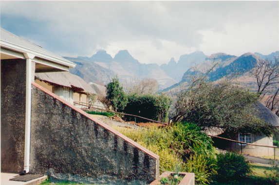
The view from the hotel. The peaks in the distance are the Inner and Outer Horns, The Bell (somewhat lower) and Cathedral Peak.
When we
arrived on Sunday evening I was pleased to discover that the hotel’s program of
guided walks included a hike up Cathedral Peak the following Wednesday and
another on Saturday. The hikes were scheduled to last 9 hours, covering a
distance of 19 km, and were marked “extremely strenuous”. At 3,005 m (9,859
ft), Cathedral Peak ZS/KN-029 is the highest summit yet activated for SOTA and
scores the maximum possible 10 points, so of course I was keen to give it a go.
Stacey agreed and since Saturday was to be our last day in the Drakensberg we
signed up for the Wednesday hike so that if the weather was unsuitable we could
try again on Saturday.
We enjoyed
some of the less strenuous walks over the next couple of days, hoping that they
would help us to improve our fitness levels and acclimatise to the altitude
since the hotel is at 1,470 m (4,823 ft) and we had come direct from our home
in Cape Town at sea level. On Tuesday evening I carefully checked and
double-checked my rig, batteries, paddle, antenna and mast before packing my
rucksack. In total I would be carrying about 15 Kg including 5 liters of water,
a first-aid kit, GPS and cold-weather gear.
Wednesday
dawned clear and still, and we enjoyed an early breakfast before joining the
hiking group at 7 am. We were given packed lunches by the hotel (more weight!)
and introduced ourselves to the other five hikers and Absolom the guide. The
hike started from the hotel and meandered through a valley and up the foothills
before the first testing stretch, a long incline aptly known as Swine Hill. At
the top of Swine Hill the GPS showed that we had climbed about 500 m (1640 ft),
about one third of the total vertical distance from the hotel to the summit.
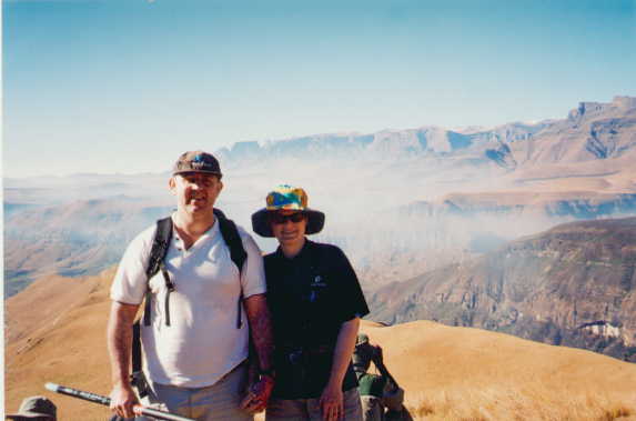
Stacey and me at the top of Swine Hill
After a
brief rest we set out along the ridgeline, watching with concern as the drop
off one side of the narrow path got progressively steeper, to the point where a
simple mistake would probably have led to an uncontrollable tumble down to the
valley below. We were relieved when path turned into a steep but picturesque
gully that led us to Orange Peel Gap, a saddle in the mountain range from where
for the first time we could enjoy a spectacular view over the northern
Drakensberg. At this point the GPS showed that we had climbed about 900 m,
nearly two thirds of the total required.
As we
reached Orange Peel Gap the wind became much stronger and gustier as we were no
longer sheltered by the mountain. I had been taking some strain during the
climb up the gully due to a combination of poor fitness and inadequate altitude
acclimatization, and Stacey was concerned about the prospect of having to
retrace our steps over the ridgeline with its very steep drop-off when we were
exhausted from a long climb. So with some regrets we decided to turn back, and
left the rest of the party to continue the hike. We eventually reached the
hotel at about 2 pm and were watching from the patio when the rest of the group
returned, tired but elated, shortly after 5 pm. We spent the next day driving
around the local villages shopping for crafts and souvenirs – anything but
walking!
Much to her
credit, Stacey agreed to let me try again on my own the following Saturday,
despite joking that I would be deserting her on our “one-week-a-versary”. This
time I discarded everything that wasn’t essential (including the camera),
reducing my pack weight to about 10 Kg. The climb to Orange Peel Gap went well,
and I was confident (and determined) that this time I would make the summit.
From Orange
Peel Gap the path follows the contours of the mountain for a couple of
kilometers, the undulating walk being a pleasant relief after the exertion of
Swine Hill and the ridgeline and giving one a chance to enjoy spectacular views
of the northern Drakensberg. Unfortunately the evocatively named “Bastard
Gully” rudely spoiled this pleasant interlude. This is a steep, unrelenting
climb over shale that rises about 600 m (2,000 ft) to barely 100 m below the summit.
I sweated and staggered and cursed every step of the way! Eventually I made it,
more through sheer obstinacy than anything else.
After
Bastard Gully the last obstacle was a set of short rock climbs. Although not
technically demanding, I found them quite stressful as I am not a good climber
and we did not have any ropes or other protection and some places a slip could
have been fatal. I was breathing heavily and was aware of the possibility of
cramp following the long climb – and cramp while ascending a rock face over a
steep drop would definitely not have been good news. Nevertheless I made it
safely with plenty of assistance from the guide Wiseman who showed me which
foot and handholds to use.
A few
minutes later I was on the rocky summit. I paused briefly for a drink and a
sandwich and then set up my station. The antenna was a dipole fed by window
line, which can be matched on any of the K1’s four bands (40m, 30m, 20m and
15m) using the internal ATU. This was suspended from a 6 m telescopic fishing
rod wedged between some rocks. I tuned to the frequency I had advertised,
14.060 MHz, and heard my good friend Vidi ZS1EL in QSO with Bernie ZS4TX – they
had both kindly been waiting for me. As soon as they signed off I called CQ and
Vidi came back to me, followed by Raoul who was manning the Boland Amateur
Radio Club’s lighthouse station ZS1BAK/L. Bernie ZS4TX was next, and then
Vidi’s wife Hester ZS1ESU came up giving me the fourth QSO that I needed to
claim the summit for SOTA.
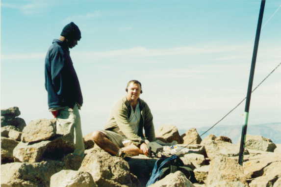
Wiseman watches me operate my Elecraft K1 at the summit
By this
time we had been on the summit for about half an hour and the other climbers
were keen to get going. I had planned to stay somewhat longer and then catch up
with the party on the way down, but after the rock climbing required to get to
the summit I decided it would be most unwise to descend on my own, so I
regretfully packed up. The walk back was long but uneventful (at least once I
had successfully navigated the rock climbs) and I arrived back at the hotel
exhausted but elated at about 5 pm, after a 10-hour hike.
My thanks
go to Stacey for her understanding, to Wiseman the guide for shepherding me
there and back, to the other climbers Mark and Sharon for sending me the photograph
they took of me on the summit, and to Vidi, Bernie, Raoul and Hester for
waiting for me and giving me the contacts I needed to bag the peak. My
apologies go to anyone else who was waiting for me but who was unable to
contact me during the very short time that I was able to operate for.
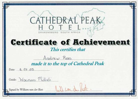
The certificate issued by the hotel to successful climbers
For more
information about the Summits on the Air program see the SOTA South Africa
website at http://www.qsl.net/sotasa or
the international website at http://www.sota.org.uk.