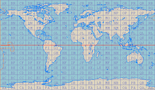
Grid Squares are being used more and more by Radio Amateurs throughout the world to identify the location of their stations. First proposed at a conference in Maidenhead, England in 1980 (and hence sometimes called Maidenhead Locators), grid squares allow three levels of precision (two, four or six character) to define a station's latitude and longitude. As will be seen by the world map on the below, the world is divided into a grid of squares that are ten degrees of latitude high by twenty degrees of longitude wide. Each square is identified by a diferent two-letter code.
The easiest way to find out your own Grid Locator is by using one of the following resources: