Cyclone Vance
[ Radar Images and synoptic chart]
Summary.
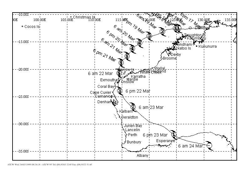
Tropical cyclone Vance was named by the Darwin Tropical Cyclone Warning
Centre (TCWC) during the afternoon of Wednesday 18 March. It was initially
located off the north Kimberley coast and moved into the area of responsibility
of the Perth TCWC overnight. Vance moved quite steadily west southwest
at first, then towards the southwest during the 20th and 21st March.
It intensifed steadily and was declared a severe Category 3 cyclone
late on 19 March. It was further upgraded to a Category 5 (the highest
category) overnight on 20 March.
The Perth TCWC posted the first cyclone warning for the Exmouth/Onslow area at 10am on Saturday 20 March. Late on 21 March the cyclone changed track to a due southerly course towards the Exmouth/Onslow area. The eye of the cyclone passed across Exmouth Gulf, approximately 25 kilometres to the east of Exmouth and 80 kilometres to the west of Onslow during Monday morning 22nd March. A record wind gust speed for the Australian mainland of 267 kilometres per hour was recorded at the Learmonth Meteorological Office, 35 kilometres south of Exmouth shortly before midday. At Onslow the maximum gust recorded was 174 kilometres per hour.
The combination of very high seas and high tides caused severe erosion of the beachfront at Exmouth. At Onslow the storm tide left three large barges stranded on the edge of Beadon Creek.
The cyclone crossed the southern part of Exmouth Gulf around 1pm then moved further inland and began to weaken. By the morning of 23 March it was near the town of Mount Magnet and was moving southeast at 50 kilometres per hour. There was damage to property in the town of Cue when winds struck the town at around 4am.
Vance was
downgraded to a Category 1 cyclone and passed to the northeast of Kalgoorlie
around 3pm. Rain from the decaying cyclone caused flooding in the southern
Goldfields. The main highway and the rail link to the eastern states
were both cut by floodwaters. It moved into waters of the Great Australian
Bight in the early hours of the 24th. The remnants of Vance caused gale
force winds over parts of South Australia and Victoria later that day.
Vance is one of (the first?) cyclones to have travelled as far south
as it did ! Tropical Cyclones are called that because they usually exist
only in the tropics.....anything south of Denham is not regarded as
tropics.
Comments or suggestions?
My email is [email protected]