|
Cyclone Thelma |
|
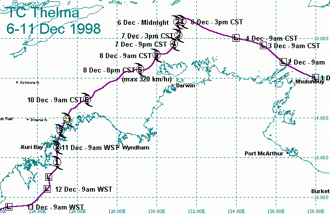
The
cyclone track and threat map of Tropical Cyclone Thelma. Severe Tropical Cyclone Thelma was the first Category 5 cyclone to be observed in the Timor Sea and to pass within 200 km of Darwin. Fortunately, Thelma's very destructive core crossed an almost unpopulated part of the Kimberley coast and remained just offshore from the western end of the Tiwi Islands in the Northern Territory. Only the periphery of the cyclone affected the more densely populated areas near Darwin. Thelma was named at 2 pm CST (Central Standard Time) Sunday 6 December about 400 km north of Darwin after which it drifted slowly south while rapidly intensifying. Thelma's intensity increased from Category 2 at 12 am on Monday 7 December to Category 4 at 9 pm on the same day. The cyclone turned towards the southwest during Monday and reached Category 5 intensity (the highest on the intensity scale) just north of Bathurst Island at about 9 am Tuesday 8 December. The cyclone reached peak intensity, with central pressure 920 hPa, and maximum wind gusts of 320 km/h, at 8 pm on the 8th, only two days after being named, having intensified at close to twice the average rate. Thelma continued moving steadily southwest at about 10 km/h before turning southwards and crossing the Kimberley coast northwest of Kuri Bay early on Friday 11 December. Apart from the rapid intensification, Thelma was reasonably well-behaved and was easy to track on radar and satellite imagery once the eye formed early on Monday 7 December. The main forecasting difficulties were associated with the cyclone's initial movement and intensification during 6 and 7 December, and with Thelma's potential impact on the Tiwi Islands, the Darwin area and on the Kimberley coast. |
|
Comments or suggestions? |