 The Canadian APRS Network
The Canadian APRS Network

Click the above logo for Southern Ontario APRS Map
UI-View APRS Software
Local Amateurs are currently running this APRS software and are putting it through its paces. Darren - VE3REK, Greg - VA3KUG, and Michael - VE3LKI / VA3LKI (Digital) started working the mode in mid-August and are impressed with the potential and capabilities for ARES work. Since then, Bob - VE3WW, Mike - VE3EQP, Richard - VE3SQT, John - VE3UJK, Maurice - VA3IRI, Derrick - VA3LAH, Russ - VE3INZ, and others, are setting up APRS stations with the UI-View software. Steve, VE3XF, also is using the UI-View software, and may be seen travelling around the countryside daily. Stations in Barrie, K-W - London, Brantford, Kingston and Ottawa areas are finding it a more than worthwhile alternative. A recent column in QST (January 2002) provided a very positive review of the program, its capabilities, and the author.
See the ARES
Digital Communication Page for more on the APRS mode and check this
link to software location - http://www.packetradio.org.uk.
Most recent 32 bit version of UI-View is V 1.69 (Feb 18, 2002). Roger
Barker, G4IDE, has just released the newest version of the 16 bit software
V 2.39 ( January 23, 2002). There is a considerable number of add-on
programs available for UI View as well, such as InfoKiosk, UI Path, UI
Route, etc.
APRS SSID's
SSID's, Secondary Station Identifiers, were developed and promoted some years ago by Bob Bruninga, WB4APR. They were intended to allow operators a means to identify a station that was not their main or base station. When using APRS, operators are encouraged to use these SSID's as for 'normal' packet radio applications. Icons are also available in the software programs to match the SSID's.
The standard secondary identifiers are as follows:
| ID # | Name |
| 1 | Ambulance |
| 2 | Bus |
| 3 | Fire Vehicle |
| 4 | Bicycle |
| 5 | Sailboat |
| 6 | Helicopter |
| 7 | Aircraft |
| 8 | Power Boat |
| 9 | Car |
| 10 | Motorcycle |
| 11 | Balloon |
| 12 | Jeep |
| 13 | Recreation Vehicle |
| 14 | Truck |
| 15 | Van |
Visit RAC columnist Jeff Robbins site for more local information at www.qsl.net/va3jtr
APRS FOR BEGINNERS - Check out the following sites for more information about APRS
http://nwaprs.org/beginners.htm
What is the Automatic Position Reporting System (APRS)?
Many of you have heard discussions about a packet radio program called The Automatic Position Reporting System, (also called APRS.) It's a system which, unlike PBBS's, nodes and DX clusters, uses an un-connected protocol to transmit your exact position, a symbol denoting the type of station you're running and a brief comment about it. It also uses direct keyboard-to-keyboard "chatting," has direction-finding capabilities and much more.
How does it work? In its most simplistic form you transmit a packet which contains your callsign, exact latitude and longitude, information on your transmitter's power, your antenna's height, gain and pattern as well as a brief comment of your choosing along with some symbols necessary to make the system work. With this information your station appears graphically on a map (actually, one in a series of many maps) on the monitor as would other stations that are on frequency. Since this is an UNCONNECTED protocol, on-air packets can be kept to a minimum.
Consider this: When you connect to a local station using standard AX.25 (packet radio mode), you send a connect request to that station, they acknowledge that packet, then sends you a connected packet which you must then acknowledge. The same thing happens with EVERY packet you, or the other station, sends. With APRS you only send ONE packet to convey your information. If it's not received on the first transmission, APRS retransmits this information using a decaying time delay (that is, the second packet is sent fifteen seconds after the first, the third thirty seconds later, the fourth a minute later, the fifth two minutes later etc. until it levels out at a period of twenty minutes!) This makes more efficient use of the frequency.
APRS uses four different kinds of digipeaters, which use the aliases RELAY, WIDE, ECHO and GATE. RELAY stations (the default setting). These are base stations used to digipeat low-power portable and mobile stations. WIDE stations will digipeat packets addressed either to their specific callsign or the generic WIDE to other VHF stations and WIDEs. An ECHO performs a similar function on HF. A GATE will digipeat from HF to VHF. When setting up APRS for your location you'll set your digi- peater path based on the situation at that QTH and where you want your information to go. For keyboard-to-keyboard communications (which are the only comms in which "ACK's" are used) you can also set alternate digipeater paths. Not only does this direct your message via the shortest possible route, but it also reduces QRM.
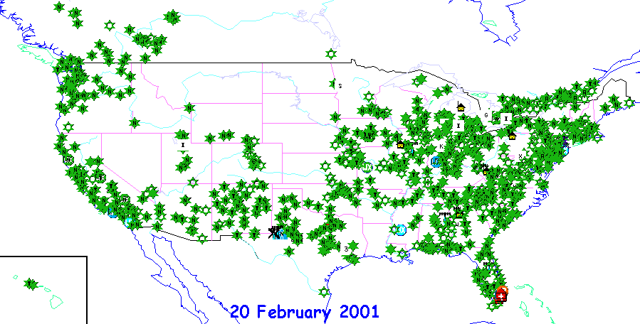 Known nodes in the APRS system @ February 2001
The program also interfaces with popular weather stations such as those made by Davis and Peet Brothers, thus allowing for real-time weather data which is available at the touch of a key. The potential for this during a SKYWARN (CANWARN in Canada) situation is obvious. You'll get wind speed and direction, temperature, rainfall amounts by the hour and 24-hour period and, in some cases, barometric readings. Such weather data can also be entered manually if a station has the information but not the hardware.
There is also a Direction-Finding mode which can be used by stations with either a beam or omni antenna! When the "fox" transmits, stations can call, by voice (on another frequency!) or keyboard their beam headings and/or signal strength. Using the antenna gain figures for these stations, circles are drawn on the map. The "fox" will usually be located where these circles converge. If you have one of the many "doppler" antenna systems they can also be used.
If DX-ing is your thing, there's also a "DX-mode" which also uses the UI protocol by simply monitoring the DX cluster frequency. As new spots are posted, they appear on the map with their callsign. Their location is based on the callsign prefix of the spot. Obviously, since you're not connected to the cluster, this isn't meant as a replacement to your normal AX.25 program, and you can't SEND messages, you can receive them (the program will flag yours and display them when asked.) It's just another tool for your county or country-hunting efforts.
If, like me, you have a Global Positioning System (GPS) receiver with NMEA-0183 output this, too, can be utilized with amazing results! Your mobile or portable position can be regularly updated. Using such a "stand-alone tracker" you don't even need a computer. All you'd need is an H/T, TNC and GPS! Think about the possibilities for such a setup in something like a marathon, walkathon or even for someone shadowing an important official. Using the message option in the software, it is possible to send NTS formatted traffic as well.
APRS was written to be able to run on just about any PC compatible computer from the latest Pentium Pro down to a lowly 8086. Heck, I know several people that use it with a Hewlett-Packard HP-200 palmtop! Maps are available from a large-scale map of the whole world to extremely detailed street-level maps. There's even a mail-reflector about it to which you can subscribe. It's lots of fun, has many potential uses for ARES / RACES / SKYWARN / CANWARN, etc., and I'm sure you'll enjoy playing with it!
by Arte Booten N2ZRC
(packet: N2ZRC@KB2VLX.#BRONX.NY.USA.NA)
(E-mail: [email protected])
Edited by Michael Moreau VA3LKI
(packet: VA3LKI@VE3REK-1.#SCON.ON.CAN.NOAM)
APRS LINKS WITH GREAT ADDITIONAL FEATURES - Check out the following sites for information about APRS, Digi-peating, WX stations, Satellite Tracking and more.
http://www.users.bigpond.com/andrew.rich/index.htm
http://www.ew.usna.edu/~bruninga/aprs.html
http://www.homepages.hetnet.nl/~remko/software/diginedE.htm
![]()
D. Lortie - VE3REK- SGBWS ARES.
Copyright © 2003 [South Georgian Bay West Simcoe
ARES]. All rights reserved.