VHF PROPAGATION Via INTENSE Es OVER THE
CONTINENTAL UNITED STATES
M.S. Wilson
EDMAC Associates, Inc.
17 Van Cortland Drive
Pittsford, New York 14534
ABSTRACT
Midlatitude Intense Es has been observed by means of oblique angle
VHF radio propagation by Radio Amateurs since the mid-1930's and, because of their
geographical distribution, their data is of value in the study of the occurrence
and movements of intense Es clouds. By plotting this data motion of the intense
Es clouds can be established with fair accuracy. An unusual, off season, intense
Es was observed on 8 November 1970 for a duration of eight hours and extending
over almost 90° of longitude and 20° of latitude, and this data was chosen for a
detailed analysis. Data over a frequency range of 50 to 144 MHz are shown for
the area over the continental United States. The data show the suddenness of the
formation of intense Es, and that individual clouds of intense Es continue to be
generated after sunset at the height of the E layer. A technique for establishing
the birthplace of intense Es and for tracking individual clouds is shown. A
model for the 8the of November 1970, locating birthplaces, cloud tracks, and cloud
velocities is suggested.
I Introduction
Intense Es has been observed by means of oblique angle
VHF radio propagation by amateurs since the mid 1930's. Their
dedication, geographical distribution, and almost continuous
observation make available valuable data for the study of the
occurrence and motion of intense Es. Early analysis of these
data by Pierce7 (1938) established the geographical location
of contours of ionization based on equivalent horizontal dis-
tribution assuming the secant law to be applicable. Conklin1,2
(1939) continued the plotting of this data and established the
skip distance distribution. Wilson9 (1941) suggested possible
wave paths via patches of intense Es rather than contours of
ionization, and indicated a westward motion of these patches.
Ferrell3 (1944) drew isopleths of equivalent ionization and
found motion of the intense Es normally moving to the northwest
at 40-150 meters per second, and suggested a circulatory motion.
Later4 he established that intense Es forms suddenly, and
identified high density cells. He suggested that the "heart"
of the cloud diffuses but that large reflecting areas were
maintained.
A cooperative research program was initiated by Ferrell
in 1949 under sponsorship of the Geophysical Research Division
of the U.S.Air Force. This effort was called the Radio Amateurs
Scientific Observations. Gerson5,6 (1950) plotted this RASO data
using the midpoint location of all transmission paths and reported
that the contours of equivalent ionization changed in both shape
and size. He found that the intense Es moved anticyclonically
first to the southwest and then to the northwest at a speed of
about 50 meters per second.
The advent of TV increased the ranks of amateur VHF
propagation observers, and Smith8 (1953) using this data plotted
the occurrence of intense Es for the summer maximum of 1950. He
related specific days with data from the NBS ionospheric station
at Washington, D.C. A second cooperative research program,called
the Propagation Research Project, was established in 1959 and was
again sponsored by the U.S.Air Force and coordinated by the
American Radio Relay League during the IGY. Most recent work
by Wilson10 (1970) suggests discrete birthplaces for the sudden
appearance of intense Es, small individual patches or clouds of
intense Es, and for the particular day studied (20 June 1968)
approximately straight line cloud tracks to the northwest at a
speed of about 90 meters per second.
II Observations by Amateurs
Extensive experimental observations of intense Es by
amateurs have been recorded and a wealth of data is available.
These observations should be a welcome and valuable source of
data in the study of intense Es. Figure 1 shows the observed
days of intense Es for the early years of observation during the
summer maxima for the years 1935 - 1942. The increase of
observed days during these early days clearly reflects the
increase in sophistication of equipment used. It should be
noted that by 1938 probably most instances of intense Es in the U.S.
were observed,and good data is available from that time to date
except for the war years.
![[summer Es 1935-1942]](w2boc-f1.gif)
Figure 1
This data shows that the occurrence of intense Es over
the continental United States varies considerably from year to
year, both in longitude and latitude, as well as in duration.
Propagation paths via intense Es are reported almost every day
from late April to mid August each year. Although the diurnal
variation appears to peak twice a day,once in the morning and
again in the early evening, on any particular day this is not usually
true. Figure 2 shows the number of daily reports of occurrence
of intense Es for the summer of 1950. The bars represent the
number of reports of transmission distance greater than 1250
miles, indicating a large geographical extent. These data are
compared to the NBS Washington D.C. ionosonde data selected for
returns of greater than 7.8 Mhz. The lack of correlation of
the observed 50 Mhz. propagation and the NBS data merely
reflects the fact that the intense Es occurrence was not
always over the eastern part of the country,although the
correlation for days of double skip, or wide geographical
area, is much better.
![[summer 1950 Es]](w2boc-f2.gif)
Figure 2
III Analyses of Amateur Data
Early plotting of amateur data consisted of noting
the location of the midpoint of the propagation path and
calculating an equivalent electron density for the given
frequency and skip distance. Points of equal density were
joined to form contours of ionization. After the war Ferrell
using RASO data plotted intense Es cloud movement and showed
the general directions taken by the clouds. His technique
was to draw a straight line between the location of the
observer and the location of the station heard, and then
marked the midpoint of the path. He developed isopleths
for a half hour period and identified a "heart" or intense
core. By making such maps for consecutive half hours the
motion of the intense Es could be found. He showed a general
enlargement of the total area covered by the intense Es. To
explain the 144 Mhz. propagation he suggested a high density
cell on the leading edge of the core. Using such maps
Gerson5 found that the motion of intense Es varied in
direction and speed for different days.
The difficulty with such a model of intense Es(using
contours of ionization)lies in the fact that it does not
explain the "negative" reports, by which is meant the case
were an active observer within range of the intense Es is
unable to hear other stations. The data show that particular
propagation paths for a given frequency are limited in range
and bearing to an area probably not greater than 50-75 miles
in diameter, (although a larger area exists for an enhanced
scatter mode.) TV recording data show that for a single
cloud crossing normal to the propagation path, the minimum
propagation loss occurs for about six minutes, and that the
signal intensity changes suddenly some 50 db for both the
leading and trailing edges. Such data imply a small patch
or cloud of intense Es. When the concept of individual
small clouds is applied, and the location of a cloud is not
constrained to the midpoint of the transmission path, the
data can be explained. Using this technique it becomes
apparent that multiple clouds are usually present, often
along a line or row, and results in multiple focusing. Many
reports of higher frequency propagation paths appear to make
use of more than a single cloud.
IV Technique of Plotting Small Intense Es Clouds
Plotting data to identify small intense Es patches
or turbulences employs the usual technique of drawing a line
on a map from the observers location to the location of the
station heard in order to establish the approximate transmission
path. The midpoint of the path is not necessarily used, but
arcs of 625 miles are drawn from each location to establish
the practical "radio horizon" for each location. This is
the major constraint on the location of the intense Es cloud.
The tangent distance of 700 miles is not used because the
data show that most observers do not attain a zero angle
of radiation from their antenna systems. If the arcs do not
intersect, there must have been more than a single cloud
present, and continued plotting will locate the positions
of the clouds. When the arcs do intersect the probability
is that the cloud is located within the common area. By
plotting the data for a few minutes at a time the location
of a single cloud may be found.
The initial location, or birthplace, of intense Es
can be determined by the beginning of the data and also by
the fact that the birthplace will continuously support
propagation paths for some time (more than an hour). Signals
propagated via a strong birthplace suffer little loss and
high levels of intensity continue with no deep fading. The
location of a birthplace appears to move at about 25 miles
per hour to the east or southeast. Individual clouds or
turbulences seem to be shed from the birthplace at discrete
times, and travel from the location of the birthplace at
a constant velocity as if blown by a wind. Some of the clouds
are short lived, but most continue in existence for many
hours and have been tracked for over eight hours. Individual
clouds which are long lived usually dissipate at some specific
latitude for the particular day. Just prior to their dis-
appearance their speed decreases. The time spacing between
individual clouds shedding vary, but the long lived clouds are
generally about a half hour apart. When the birthplace
dissipates few if any new clouds are generated.
The location of a birthplace of intense Es is often
related to weather fronts in the troposhere and many times
appear over a squall line or areas of precipitation. The
data show that the location of a birthplace for subsequent
days moves eastward with the tropospheric weather pattern
at an average of 12½ degrees of longitude per day. Hot
air from Mexico and the Gulf of Mexico often relates to
a birthplace.
IV Intense Es Observed 8 November 1970
Intense Es observed on 8 November 1970 was most
unusual in that it was of long duration, extended over a wide
area, and was off season. Reports from the east coast of
the United States to as far west as Hawaii, and from the
northern border of the United States to the tip of Florida
and Mexico were received.Scattered reports of intense Es
were received for the morning and afternoon,but the consistent
time span for 50 Mhz. propagation was from 1800 to 0140 EST.
The highest frequency of propagation reported was 144 Mhz.
and these reports covered a time span of about two hours.
The greatest distance reported at 144 Mhz.was 1300 miles,
for 100 Mhz 2000 miles, and for 50 Mhz more than 4000 miles.
Widespread reports of direct backscatter from intense Es clouds
at 50 Mhz. and one report of direct backscatter at 100 Mhz.
were received.
At least ten different birthplaces were identified
across the continental United States and the begining time
for all was within a thirty minute period. The first birth-
place observed was located near El Paso Texas at 1750 EST
and the second near Washington D.C. at 1913 EST. The
suddenness of the onset of intense Es is illustrated in
figure 3, which is a field strength recording of the
amplitude of the video carriers of two channel 4 TV stations.
Chart speed is 1 mm per minute, and the amplitude is recorded
from noise level (approximately 1 microvolt at receiver
input) to amplifier overload (approximately 1600 micro-
volts at receiver input) on a non-linear scale. The
lower recording shows the signal strength of TV station
WTVJ located at Miami, Florida and illustrates the sudden
increase of signal strength in about a minute of time as
the MUF exceeded the frequency. (67.250 Mhz.). The propagation
path distance was approximately 1250 miles. The upper record-
ing is the signal strength of TV station WJXT located at
Jacksonville Florida at a shorter distance of about 950
miles.
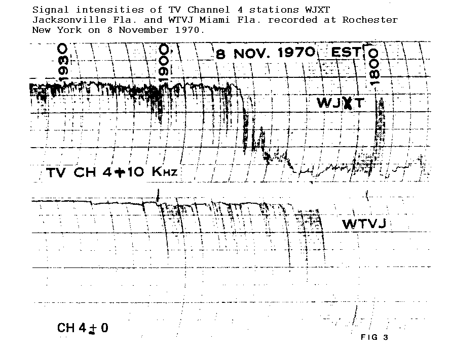
Figure 3
Figure 4 shows the transmission paths reported at 1900 EST about an
hour after the initial appearance of the intense Es. Clouds over the
eastern part of the country began to support FM frequencies and short skip,
and backscatter was reported from very intense clouds along a line from
Washington, D.C. to Western Pennsylvania. TV propagation began from
clouds over the central states and TV stations were heard over single skip
distance from the southern west coast. 50 Mhz double skip existed from
Arizona to Ohio, and southern California continued to report the Kansas
area but no double skip.
At this time intense Es was present over at least 80 degrees of
longitude and observers in Hawaii began to hear stations as far east as
West Virginia. The detailed data show that the Hawaiian signals were
focused to relatively small areas at any given time, and stations 50-75
miles away from these areas were unable to hear the Hawaiian stations.
![[Figure 4 - 50-, 75-, and
100-MHz paths at 1900 EST]](w2boc-f4.gif)
Figure 4
By 1930 EST 144 Mhz propagation paths were reported over the southern
central states. FM reports increased over the eastern states and pro-
pagation paths were reported over the central and western states. 50
Mhz paths covered the country and coast-to-coast propagation was reported.
A half hour later at 2000 EST 144 Mhz transmission paths were reported
from Texas to southern California and one report from Kansas to Virginia.
FM propagation paths disappeared over the eastern section and began from
the panhandle of Florida to the Denver, Colorado area which was to last
for more than two and a half continuous hours. Another FM path was
observed from Iowa to the Arizona-New Mexico area. By 2030 EST the 144
Mhz reports were from Wyoming to Texas and from Nebraska to southern
California. FM propagation paths were spreading west to southern
California and north to Minnesota. 50 MHz paths remained strong.
At 2100 EST a 144 Mhz path was present from Nebraska to southern
California, the FM paths had reached Idaho and a double skip path opened
from Idaho to Mexico. The 50 Mhz propagation paths which for single skip
distance had been creeping up the California coast had reached Santa Maria
at this time. A half hour later the last 144 Mhz path was reported from
Nebraska to southern California. The FM double skip from Idaho had
shortened to southern Texas, and FM double skip was reported from Santa
Maria, California to Illinois. The 50 Mhz paths became very short over
the northeast section of the country.
FM propagation was still being reported at 2200 EST over the central
and eastern United States, but was beginning to weaken. The FM path from
Idaho continued to shorten and was now into New Mexico. 50 Mhz paths
continued to be reported coast to coast from San Diego to New York City.
An hour later at 2300 EST intense Es no longer supported the FM frequencies
and the 50 Mhz coast-to-coast paths were beginning to creep up the coast
of California and continued to go northward over the eastern end of the path.
At 0000 EST the coast-to-coast 50 Mhz propagation paths still existed
although most of the clouds were beginning to disappear. By 0030 the far
west clouds had reached a position to support 50 Mhz paths from Southern
California to the northwest corner of the United States. The coast-to-coast
path had now reached as far north as San Francisco.
An hour later at 0100 EST most of the clouds had dissipated and the
coast-to-coast path disappeared. One very persistent cloud had reached
upper Michigan, the highest latitude reached for the day, and allowed
a Connecticut to Minnesota path to exist. This particular cloud had been
responsible for the very short skip at 50 Mhz some two hours earlier when
over the Maryland-Pennsylvania border. At this time all the remaining
clouds began to dissipate, and by 0130 only one cloud could be found from
the data and the last report was at 0157 EST.
A model which explains the detailed data for this day is shown in
Figure 5. The tracks are required and the birthplaces for nine tracks
are shown. The tracks are shown as straight lines on the map but because of
map distortion the actual tracks may be somewhat curved, especially over
the western half of the country. Note that most of the lead clouds dissipated
before reaching 43 degrees north latitude. The lead cloud for the track
fourth from the left was tracked for almost seven hours as it travelled from
the Oklahoma-Kansas border to northern California. Many other clouds were
generated and these clouds followed the lead clouds on each track. Most of
the birthplaces had dissipated by 2100 EST, although the Washington, D.C.
birthplace did generate some clouds after the continuous phase had ended. Note
that the location of the birthplaces starting on the left seem to first be
on a line in a northeast direction, then across the country just above 30
degree north latitude, then up the east coast. Figure 6 shows the surface
weather map for the 8th of November 1970 and illustrates a typical relation-
ship between the location of a birthplace of intense Es and the interface of
large air masses on the earth's surface. This coincidence should not be ignored.
![[Figure 5 - Es Cloud Tracks 8 Nov 1970]](w2boc-f5.gif)
Figure 5
![[Figure 6 - Surface Weather Map for 0700 EST 8 November 1970]](w2boc-f6.gif)
Figure 6
Conclusions
The volume of simultaneous data collection by a large number of
geographically spaced observers makes possible the construction of a model
of intense Es, and emphasizes the value of amateur VHF observers'
contributions.
A model of the birthplaces and movement of intense Es clouds based
on amateur observers' data for the 8th of November 1970 has been presented.
This analysis of an off season occurrence of intense Es when compared to a
like analysis for a summertime occurrence indicates little difference in
the movement of the intense Es clouds.
Acknowledgement
The author wishes to express his appreciation to the hundreds or Radio
Amateur Operators and the TV-FM Dx-ers for their data,without which this
analysis could never have been accomplished.
REFERENCES
1. Conklin, E.H. W9BNX (1939) 56 Mc. Reception via
Sporadic E Layer Reflection Proc.IRE Vol 27
pp36-41
2. Conklin, E.H. W9BNX (1941) That 5 and 10 Meter Skip
RADIO No. 256 pp40-44 (Feb)
3. Ferrell, O.P. (1944) Radio Investigation of Air Move-
ment in the Upper Atmosphere Science and Culture
Vol 9 p 555 (June)
4. Ferrell,O.P. (1948) Correspondence Proc. IRE Vol 36
pp 879-880 (July)
5. Gerson, N.C. (1950) NATURE Vol 116 pp 316-317 (19 Aug.)
6. Gerson, N.C. (1951) American Geophysical Union Vol 32
No. 1 pp 26-30 (Feb)
7. Pierce, J.A. W1JFO (1938) Interpreting 1938's 56 Mc. DX
QST Vol XXII No. 9 p23 (Sept)
8. Smith, E.K. (1953) The Effect of Sporadic E on TV
Reception Radio Electronics Vol 24-6 p 54-56 (June)
9. Wilson, M.S. W1DEI (1941) Five Meter Wave Paths QST
Vol XXV No 8 and 9 (Aug-Sept) p 23-27
10. Wilson, M.S. W2BOC (1970) Midlatitude Intense Sporadic
E Propagation QST Vol LIV No 12 p 52-58 and QST Vol
LV No 3 p 54-57