Welcome to PE1RAH
OSCARLATOR.
At the
holliday/dx-expedition through Europe there was one problem for tracking the
satellites. The problem was that I could not take my computer with me for
satellite tracking. It was not possible
for several reasons:
-
It was just to heavy to carry as extra load in
my back-pack.
-
My laptop was to fragile to outstand this long
and rough travel.
-
It is another expensive unit to take care of.
(against thieves, but also rain and dirt)
-
It takes the most current of all my HAM equipment
!!!! I would need also 3 extra batteries for this PC.
So, all these things
together made me to find some other solution. I found some solution by making
an list of the azimuth and elevation data of the complete travel time. Then
another problem appears. While travelling you change your qth everytime, and
the azimuth and elevation data also changes. Because I had planned the complete
route before, I made sevaral lists of az/el data with the different qth
locations.
This system worked
very good, but only because the route was planned in detail before !!
After my arrival back
home, I wanted to find some other system that is independent with the qth
location. After I put some message on AMSAT-BB I received several emails of
amateurs that told me about the OSCARLATOR system.
I never heared about
this system because it is used a long time before I became an active HAM radio.
Then David Zatopek helped me by sending me some samples of the system by mail.
It were samples of old satellites, but now I had some idea how the system
works. After I find out how the system works, I started to find out how to
update the “old” system. After many hours of calculating, drawing, and testing
I found out how to upgrade the system with todays newer satellites.
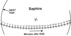
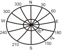
The OSCARLATOR
tracking system uses as basic a polar map of the northern hamosphere. To track
an satellite, an overhead with the satellites orbit has to be placed over this
polar map. The overhead difines the orbit (at the northern hamosphere) of the
wanted satellite. The last thing what is needed, is the time and place of the
satellites equator crossing (EQX), to know the relation between the satellites
orbit and the earth. This list can be made by some satellites tracking
programs.
What do you need:
-
The OSCARLATOR map
-
Overhead with satellite orbit of the satellite
you want to track
-
A list of EQX’s
OSCARLATOR gives you:
-
Position of the satellite at every time.
-
The time when the satellite will be “visible”
for you.
-
The azimuth/elevation data at your location of the
earth, to know what direction to point your antennas to.
-
The footprint of the satellite.
Compaired to a
computer:
-
It is small and light weight to carry.
-
It is not very expensive, and there can be made
spare copies very easy.
-
It is not fragile, and takes no extra current
what decreases battery life, and also DX time.
At AMSAT-BB I put
some message and asked if there are more amateurs interrested in this system to
use. I was very suprissed to receive so many positive answers. Because of this
I made this I will include my already made satellite overheads charts on my
webpage for download.
!!!! I did test the
charts several times, but still there can be made some mistakes !!!!
The polar map.
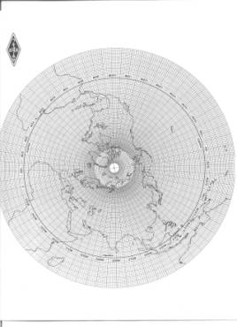
KLIK HERE, to download this map
in PDF format. (2,3Mbytes !!!!)
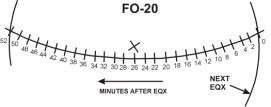
FO-20 overhead.
FO-29 overhead.

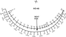
AO-40 overhead.
AO-40 footprint
overhead.
Saphire overhead.
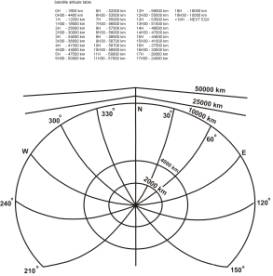
Azimuth/elevation for
LEO overhead.
KLIK HERE, to
download the satellite overheads (50kBytes .PDF
file)
AO-7 OVERHEAD NEW !!!!!!
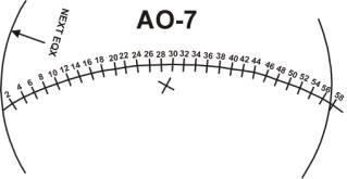
KLIK HERE, to download the AO-7
overhead (10,3kBytes .PDF file)
I am little busy now
but I will make more satellite overheads when I have some time left for it.
73 de PE1RAH, William.