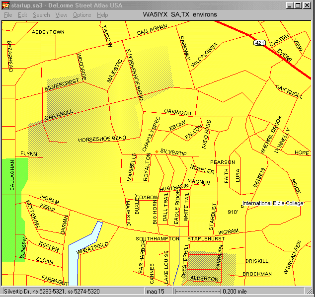
Map of WA5IYX Environs
(image map - move cursor around)
29° 28' 09" North
98° 25' 32" West
(830' ASL)
(from 1995 DeLorme Version)
   When we moved here in June 1972 the zone north of Silvertip to Oakwood was
empty.  Silvertip deadended at Big Horn, with no housing after the west side
of Big Horn until Callaghan Road.  The area north of Oakwood bounded by
Callaghan and Highway (Spur) 421 (aka Bandera Road) consisted mostly of large
(acre-sized) lots of residential housing in a heavily wooded environment
(helping to conceal the fact that there were some 50 dwellings!)  Some of the
structures dated to the 1940's (and I suspect that their power poles did as
well).  A calculated risk was that there are 80' high high-tension (180-kv)
pylons along the east and south sides of Callaghan Road running to a power
substation (off map) on the nw intersection of Callaghan and Bandera.

   After years of bad line noise problems at various QTH's, this immediate
subdivision was largely chosen because of its underground utilities.  But,
"regular" power lines are as close as Majestic to the West, Oakwood to the
North, Stardust to the East, and Ingram to the South.  Some of the convoluted
street routing makes locating such (even nearby) RFI a long road trip.  The
east end of South Horseshoe Bend no longer connects to East Horseshoe Bend.

   In the near-30 years here lots of RDFing of RFI has gone on.  By far the
most-distant was an electric fence (just off map north of Abbeytown) in an
industrial park area - around a small horse corral.  This was in the little
incorporated entity known as Leon Valley, which, unlike San Antonio, did NOT
have a city code against them!  That city code had enabled a quick resolution
of a few other closer ones: (1977-78) north side of Oakwood (a horse corral),
and one on the southside of Callaghan north of Fermi (insulators on wood atop
a backyard cyclone fence).

   In early 1996 a broken street light on a pole on the northeast corner of
Silvercrest and Callaghan (some 3000' away) was an RFI source.  Another, much
closer, one that year was a deadend pole along East Horseshoe Bend (about 700'
away).  Since the pole led or fed nowhere, they just simply de-energized it!

   The area between Silvertip and Oakwood, though long shown on various city
maps with street names (even before Silvertip was made!), did not get any
residences built until the late 1970's.  The closest north was not until
1985.  The adjoining north lot remains vacant (and, in hindsight, probably
should have been acquired when it was $2,000 instead of the current $10,000
in order to keep it so!)  Most of those houses were custom built, several
being two stories.  But, the area being in a hollow, their rooftops often
are at near eye level from this higher land.  The local TV "antenna farm" is
southeast, so some down there had to beam across me for that!

   CATV service to this area was late in coming because of the retrenching
needed across all the backyard easements with the underground utilities (the
phone comes thru the rear, the electric power from the street curb area).
It wasn't until late 1981 when that was done.  While it has undoubtedly
helped reduce TVI cases it is a double-edged sword.  No longer can those with
CATV see the RFI/EMI effects of their various faulty electrical appliances,
etc that still affect me!  In the past when tracking such things down one
could ask "Is your TV experiencing electrical interference?" as a means of
getting a common-problem resolved.

   Again, the street pattern is a real pain.  For instance, a noise source in
a residence in those cul-de-sacs (and there have been such as ceiling fans)
as close as 400 feet requires a one-way road trip of a mile to reach!  Easier
to get to and locate was another ceiling fan 600' away of the west side of Big
Horn in July 1991.

   The 910' ASL point marked in the above is also where a city water board
standpipe once was located.  From that hill I've mused that the next highest
piece of land to the southeast must be in Venezuela!  (And to the east maybe
Africa.)  Again a double-edged sword effect since the entire San Antonio
downtown area with its multitude of rf sources (including several 100-kw FM
broadcast stations at about 6 miles) is line of sight!  Sometimes a hill can
provide very useful shadowing effects from intermod from overload, etc.

Update: In 2002-2003 the remaining adjacent vacant lot was built upon.  The
evolution of that can been see in these archival Google Earth images
Sep 28, 2002
Jan 01, 2003
Dec 01, 2004
The latter also well shows my 15-m, 10m, 6-m, and 2-m antennas!
Update: In 2002-2003 the remaining adjacent vacant lot was built upon. The evolution of that can been see in these archival Google Earth images Sep 28, 2002 Jan 01, 2003 Dec 01, 2004 The latter also well shows my 15-m, 10m, 6-m, and 2-m antennas!