I was operating from a hill (elevation 2844') in Joseph D. Grant County Park. The hill doesn't have a name as far as I've been able to determine. Click here to see the location of the hill on a topographic map. I chose it because it seemed like a high point that was within reasonable hiking distance given the amount of daylight we had to work with. I really wanted to go all the way to Antler Point, but that was a 4 mile hike one way and we didn't start early enough in the day to allow for that kind of distance.
|
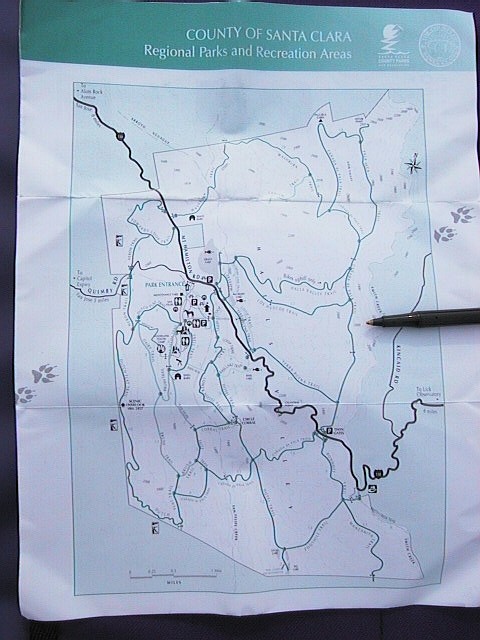
Here's a map of Joseph D. Grant County Park showing the location of the hill that I operated from. The pen is pointing to the exact spot. |
 |
Here's a portion of the same map blown up to show the 2800' elevation of the hill. This is the map I used to pick out this spot before we even set out on the trail. According to the map, it was about a 1.5 mile hike from the parking lot. |
 |
The trail had some great views along the way. That's the southern end of the San Francisco Bay up ahead in the distance. |
 |
Here's what the hill looked like from the trail on the way up. As you can see, it's the highest spot around this part of the park. |
 |
This picture was taken looking back down the trail from where we came. On the trail I was listening to 146.520 MHz on the VX-150. I heard W6DNE who said he was 4-wheeling in the Santa Lucia Mountains near Mt. Carmel. Then I heard Norm (KC6ZWT) in Placerville call him to see if he could make the contact. After they finished their exchange, I tried calling W6DNE. He had no trouble hearing me running 2w into the stock duckie and he was full scale on my HT. In this picture you can see that the Santa Lucia's were line-of-sight from where I was located. At that point on the trail, Norm's signal wasn't that strong, so I figured I'd wait until I got to the top of the hill and hooked up the beam before I'd try calling him. |
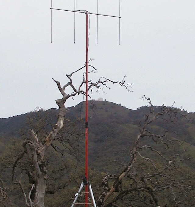 |
After about an hour of hiking, I arrived on top of the hill and set up the tripod mount, telescoping mast, and beam. If you look closely in the center of this picture, you will see Lick Observatory on Mt. Hamilton. The observatory looked very close, close enough to be able to see the windows in the main building with the naked eye. When I got set up to operate on 146.520 MHz FM simplex, I gave Norm (KC6ZWT) a call. He operates from the Eldorado Hills near Placerville, and is someone I try to contact when I'm out hilltopping. He was full-scale on my HT as usual and he said I was S9. I was running the VX-150 at 2 watts at the time. I also gave W6DNE (Rocky) another call and we had nice QSO discussing hilltopping locations in the Santa Lucia Mountains. I got some good tips from him in case I ever decide to hike up to Junipero Serra Peak. |
 |
Here's the view from the hill looking toward the southwest. That's Loma Prieta in the distance just to the left of the mast. That's the ridge above the Evergreen Valley in the foreground. I took this picture after working on 144.200 USB. I was pleasantly surprised at the number of contacts I was able to make on sideband that day. I talked to stations in San Jose (KD6VS, W6KLH, KI6JD), Pollock Pines (WA6QAK), Novato (WA6JYU), Benicia (KG6OQK), Placerville (KC6ZWT), and Wilton (K6NC). Mike (K6NC) suggested I check out Pyramid Peak for future a hilltopping location. Thanks for the suggestion, Mike. |
 |
Here's the view from my operating location looking toward the San Francisco Bay. This spot may not have been as high as Mt. Hamilton, but it was sort of remote, which is part of the fun of hilltopping. Even though the sky became overcast as they day wore on, I still had an enjoyable hilltopping experience. I have wondered if I'd ever run out of hills to hike in the Bay Area, but a week ago I wasn't even aware of this location, so I think there are still plenty of hills out there to operate from in the area. |