CCD Images of the moon and more
Antonio Fern�ndez
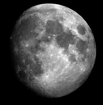
Gibbous Moon
In most cases the moon is the entry level target for CCD astrophotography and judging by the results that the novice atrophotographer, as is my case, can achieve a very rewarding one. There is no need for sophisticated equipment and decent results can be achieved with conventional digital cameras and computer videoconference cameras. All the images in this page, but those from NASA, were obtained with a Olympus C-2020 Z digital camera using an afocal projection system. Images were produced from single raw frames from the camera (i.e. no stacking was used in the processing of the images). The gibbous moon on the top was shooted with a Celestron 80 mm "short tube" refractor (f/4). The other images were shooted with a Meade LX-90 20 cm Schmidt-Cassegrain reflector (f/10). North is up in all photographs in this page.
Lunar Topography
1 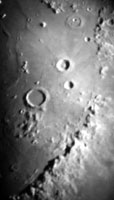 2
2
 3
3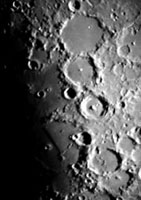
1.- The study of the moon surface is fascinating, there is
no other celestial body in which we can observe the level of detail the moon shows. Most
of the other planetary targets are either to far to see details in their surface or have
an atmosphere veil that makes their surface unreachable for us.
The lunar surface is very rich in topographic features: craters, mounts and maria
(seas) are among the most interesting.
The photo on the left shows the eastern shore of Mare Imbrium, located in the northwest
part of the close-side of the moon. The craters Archimedes (the big one, south of other
two), Aristillus (North) and Autolycus occupy the center of the picture. The north part of
the Appennine mountains can be seen east of Archimedes, this is an interesting feature as
this was the site of Apollo 15 "landing".
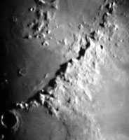
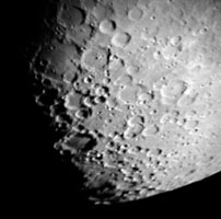
2.-The south part of the Apennine mountain range can be seen in the center photo. The Appeninnes are high mountains: the highest peaks rise about 5000 meters (16000 ft) above Mare Imbrium surface. The light of the Sun is coming from the east and the peak shadows can be seen on Mare Imbrium's surface. The crater Erathostenes can be seen in the lower left of the photo. Erathostenes is very close to the terminator (the line separating light from dark) and that's why appears so dark.
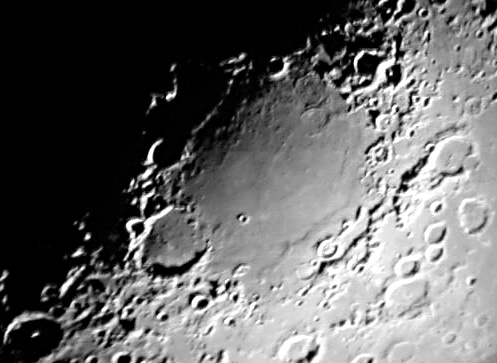
3.- The third image on the left shows -among others- the craters Ptolemaeus, Alphonsus and Arzachel located next to eastern shore of Mare Nubium. Most of the craters in the moon are the result of meteorite impacts. In most impact craters a sharp mountain peak can be seen in the center. The origin of these center peaks is the volcanic activity after the impact. Thus they could be "secondary" volcanos due to the impact. There are also primary volcanic craters that are originated from the moon's own volcanic activity. The latter are usually smaller than the impact craters.
Been there!
4 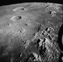 5
5 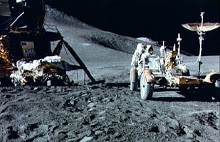
One of the best things of the moon is that "we have been there". Apollo missions landing sites are among my favorite moon targets. So, how my images compare to those taken in situ? The answer is here. The image on the left, taken from Apollo 15 command/service module, shows part of what you can see in my picture #1 above. The image on the right shows the Lunar Module "parked" in the vicinity of the Appenines. Please refer to the text below (Text and Images �NASA). Click here to view a side by side comparison of the two images.
4.- NASA Photo ID: S71-44667 File Name: 10075716.jpg Film Type: 4x5 BW Date Taken: 08/25/71 Title: View of Hadley-Apennine area, looking north, photographed by Apollo 15 Description: An oblique view of the Hadley-Apennine area, looking north, as photographed by the Fairchild metric camera in the SIM bay of the Apollo 15 Command/Service Module in lunar orbit. Hadley Rille meanders through the lower center of the picture. The Apennine Mountains are at lower right. The Apollo 15 Lunar Module touchdown point is on the east side of the "chicken beak" of Hadley Rille. The Caucasus Mountains are at upper right. The dark mare area at the extreme upper right is a portion of the Sea of Serenity. The Marsh of Decay is at lower left. The large crater near the horizon is Aristillus, which is about 55 kilometers (34.18 statute miles) in diameter. The crater just to the south of Aristillus is Autolycus, which is about 40 kilometers (35 statute miles) in diameter. The crater Cassini is barely visible on the horizon at upper right.
5.-NASA Photo ID: AS15-86-11602 File Name: 10075735.jpg Film Type: 70mm Date Taken: 07/31/71 Title: Astronaut James Irwin works at Lunar Roving Vehicle during Apollo 15 EVA Description: Astronaut James B. Irwin, lunar module pilot, works at the Lunar Roving Vehicle during the first Apollo 15 lunar surface extravehicular activity (EVA-1) at the Hadley-Apennine landing site. A portion of the Lunar Module "Falcon" is on the left. The undeployed Laser Ranging Retro Reflector (LR-3) lies atop the LM's MOdulear Equipment Stowage Assembly (MESA). This view is looking slightly west of south. Hadley Delta and the Apennine Front are in the background to the left. St. George crater is approximately 5 kilometers (about 3 statute miles) in the distance behind Irwin's head. This photograph was taken by Astronaut David R. Scott, Apollo 15 commander.
Professional vs. Amateur
6 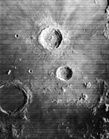 7
7 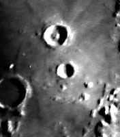
Now that you are familiar with Aristillus and Autolycus let me show
you yet another comparison, but before a few words about Clementine.
Clementine was a joint project between SDIO and NASA. One of the objectives of the
mission was to make scientific observations of the Moon and the near-Earth asteroid 1620
Geographos. The observations included imaging at various wavelengths including ultraviolet
and infrared, laser ranging altimetry, and charged particle measurements. Clementine was
launched on 25 January 1994 from Vandenberg AFB aboard a Titan IIG rocket. After two
Earth flybys, lunar insertion was achieved on February 21. Lunar mapping took place over
approximately two months. The spacecraft orbited the moon in a polar orbit with a
perilune of about 400 km. After leaving lunar orbit, a malfunction in one of the on-board
computers caused a thruster to fire until it had used up all of its fuel, leaving the
spacecraft spinning at about 80 RPM with no spin control. This made the flyby of
Geographos impossible. (for the AMSAT crew reading this, does it sound familiar to
you?;-)).
The image on the left (6) was taken by Clementine from about 400 km. The picture of
the right (7) was taken by the author of these pages with modes equipment from his
backyard at a distance of about 382000 km from the moon.
Clementine Project Information
Moon Poles
8 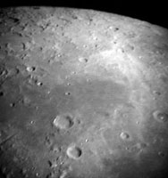 9
9
The image on the left (8) shows the moon north pole region. The Mare Frigoris is the dark flat lava surface in the center image, the two big craters are Aristoteles (in the south shore of the sea) and Eodoxus (south of Aristoteles). The south pole (right, 9) shows a larger number of impact craters than the north pole. The large crater next to the terminator is Maginus.
Guess What?
I have a few megabytes of moon images I have taken during my photographing sessions. I have not yet identified many of them so... why don't you give a try to this image? If you identify the lunar features and orientation please e-mail me at [email protected] . There are no other prizes that just the fun of the lunar challenge ;-)
� Copyright 1983 - 2001 by Antonio Fern�ndez unless otherwise noted. All rights reserved. Contents of these pages, including photos and text, may not be reproduced, published, copied or transmitted in any form without written permission of the author.