There are no active watches, warnings or advisories
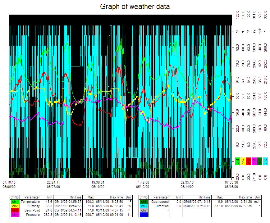
| KB0EPY's Weather Data | |||
|---|---|---|---|
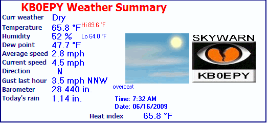
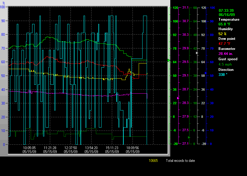
| LAST READING AT TIME: 7:32 AM DATE: June 16 2009 | |||
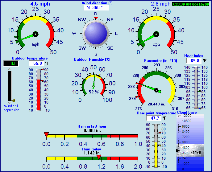
| Current Weather | Dry | Current Temperature | 65.8°F (18.8°C) (Heat Index 65.8°F ), Apparent temp 64.9°F |
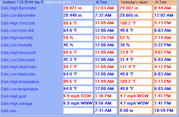
| Maximum Temperature (since midnight) | 89.6°F at: 11:09 AM | Minimum Temperature (since midnight) | 64.0°F at: 12:00 AM |
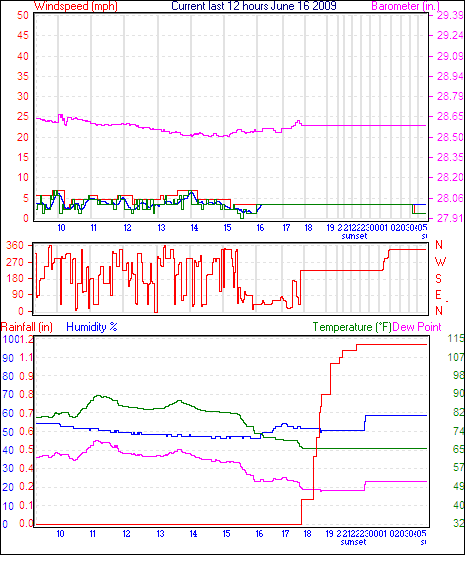
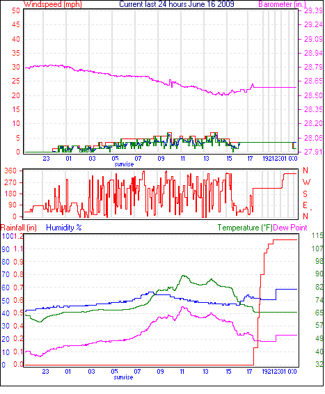
| Average windspeed (ten minute) | 3.5 mph | Wind Direction (ten minute) | NNW (337°) |
| Heat Index | 65.8°F | Maximum Gust (last hour) | 3.5 mph at: 6:31 AM |
| Maximum Gust (since midnight) | 6.9 mph at: 1:36 PM | Maximum 1 minute average (since midnight) | 6.9 mph at: 9:56 AM |
| Rainfall (last hour) | 0.00 in. (0.0 mm) | Rainfall (since midnight) | 1.14 in. (29.0 mm) at 4:22 AM |
| Rainfall This month | 1.97 in. (50.0 mm) | Rainfall To date this year | 1.97 in. (50.0 mm) |
| Maximum rain per minute (last hour) | 0.00 in/min | Maximum rain per hour (last 6 hours) | 0.83 in/hour |
| Yesterdays rainfall | 0.00 in | DewPoint | 47.7°F (Wet Bulb :56.3°F ) |
| Humidity | 52 %, Humidex 67.1°F | Barometer corrected to msl | 28.440 in. (963.1 hPa) |
| Pressure change | 0.00 in. (last hour) | Trend (last hour) | STEADY |
| Pressure change (last 12 hours) | -0.06 in | Pressure change (last 6 hours) | +0.07 in |

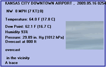
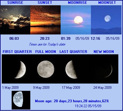
Expires:200905151100;Remove:200905151100;939411
FPUS73 KEAX 150850
NOWEAX
SHORT TERM FORECAST
NATIONAL WEATHER SERVICE KANSAS CITY/PLEASANT HILL MO
350 AM CDT FRI MAY 15 2009

KSZ103>105-MOZ028-029-037-151100-
LEAVENWORTH-WYANDOTTE-JOHNSON KS-PLATTE-CLAY-JACKSON-
INCLUDING THE CITIES OF...LEAVENWORTH...KANSAS CITY KS...
OVERLAND PARK...OLATHE...PARKVILLE...PLATTE CITY...WESTON...
LIBERTY...EXCELSIOR SPRINGS...KANSAS CITY...INDEPENDENCE
350 AM CDT FRI MAY 15 2009
.NOW...
ISOLATED SHOWERS AND THUNDERSTORMS WILL BE POSSIBLE
THROUGH 5 AM...WITH A LULL IN ACTIVITY EXPECTED UNTIL
SUNRISE. ANY SHOWER OR THUNDERSTORM THAT DEVELOPS
WILL RESULT IN RAINFALL BETWEEN A TRACE AND ONE TENTH
OF AN INCH.
$$


KANSAS CITY DOWNTOWN AIRPORT , MO, United States (KMKC) 39-07N 094-36W 227M
May 15, 2009 - 10:54 PM EDT / 2009.05.16 0254 UTC
Wind: from the NW (320 degrees) at 8 MPH (7 KT):0
Visibility: 10 mile(s):0
Sky conditions: overcast
Precipitation last hour: A trace
Temperature: 64.0 F (17.8 C)
Dew Point: 62.1 F (16.7 C)
Relative Humidity: 93%
Pressure (altimeter): 29.89 in. Hg (1012 hPa)
Pressure tendency: 0.04 inches (1.5 hPa) higher than three hours ago
ob: KMKC 160254Z 32007KT 10SM OVC008 18/17 A2989 RMK AO2 RAE10 CIG 006V011 SLP114 P0000 60006 T01780167 53015
cycle: 3
Use the RELOAD facility on your browser to retrieve the latest data.