

![]()
![]()
![]()
![]()
![]()
![]()
| The Basics of VHF Signal Propagation Ground Wave - Ground wave propagated signals are signals that, generically speaking, travel along or close to the Earth's surface on their path between the transmitting and receiving antennas. These signals do not use reflection or refraction from the various regions of the atmosphere to get from one place to another. Ground wave signals are the "local" signals we receive. They are the signals that are always present, day and night. Ground wave signals are not dependant upon any particular atmospheric or ionospheric conditions to travel from the transmitting antenna to your receiver. The ground wave consists of two components, the surface wave and the space wave. The terms "space wave" and "ground wave" seem to be used almost interchangeably, even though it's not exactly correct to do so. The surface wave travels out from the transmitting antenna, remaining in contact with the Earth's surface. The surface wave is primarily responsible for the reception of local AM broadcast signals. The strength of the surface wave diminishes rapidly with distance because the Earth is a not a particularly good electrical conductor. Also, the attenuation of surface wave signals increases dramatically as the signal frequency is increased. At the FM band frequencies (88 to 108 MHz) the surface wave is virtually nonexistent, and is generally not a factor in our reception of FM band signals, local or otherwise. Reception of local FM signals relies almost entirely upon the space wave component of the ground wave. The space wave signal path is the so-called "line-of-sight" path between the transmit and receive antennas. The curvature of the Earth is the primary limiting factor for the maximum distance a space wave propagated signal can travel. The space wave will travel outward from the transmitting antenna until it reaches the horizon. Beyond that point, the space wave is blocked by the Earth itself, and reception is no longer possible for a receiver located on the surface of the Earth (as most are). It's important to note, however, that the optical horizon (the horizon you can see) and the "radio horizon" are not the same. In reality, the space wave does not quite travel in a straight line as it moves away from the transmitting antenna. Instead, the signal travels in a slightly downward curved path that keeps it nearer to the Earth's surface, thus extending its path a little further than the optical horizon. If you are into math, the approximate distance (in miles) to the radio horizon can be calculated by multiplying the square root of the antenna height (in feet) by 1.415 times. For example, the distance to the radio horizon for an antenna 1,000 feet above the ground is just under 45 miles.
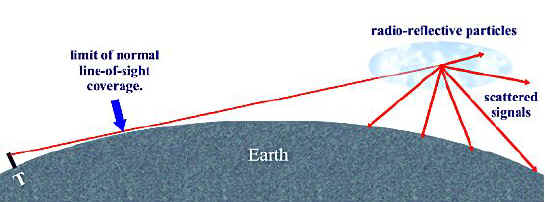
All this, of course, assumes that the Earth is a perfectly smooth sphere, and that no signal disturbances or enhancements occur along the path between the transmit and receive points. As we know, the Earth is not a perfect sphere, and the space through which the radio signal travels is not perfect either. FM signals can be either attenuated or enhanced by various path imperfections. Hills, buildings, trees and other physical obstacles along the signal path, as well as a variety of atmospheric and ionospheric conditions serve to either reduce or enhance our FM reception. We'll concentrate on the enhancements that make it possible for FM signals to travel hundreds and even thousands of miles. Tropospheric Enhancements - Under normal conditions, the path of an FM signal that is not blocked or obstructed simply travels out into space, never to be heard again. However, various conditions - mostly weather related - within the atmosphere often cause the normal path of FM band signals to be bent downward, returning the signal to the surface of the Earth. Other conditions cause the signal to be reflected, again returning the signal to the surface of the earth. Within the broad classification of tropospheric enhancement, there are several different and distinct signal propagation modes, which make it possible for FM signals to travel far greater distances than the normal radio line-of-sight horizon. As a rule, the tropospheric enhancement of radio signals tends to increase with frequency. At FM band frequencies, located within the Very High Frequency (VHF) region of the radio frequency spectrum tropospheric enhancement can be quite pronounced. The majority of tropospheric effects are less common in the mountainous and dry, desert-like regions of the Rocky Mountain and Western States, while more prevalent in the relatively flat and more humid climates of the Midwest, East Coast and Gulf States. Tropospheric Scatter - Tropospheric scatter is probably the most common form of tropospheric enhancement. Tropo-scatter is always present to some degree just about everywhere. Tropospheric scatter is caused when radio signals are reflected by small particles or droplets suspended in the air, such as dust, water, smoke, volcanic ash, and other reflective impurities. The signal is scattered in random fashion, with some of the signal returning to Earth where we can receive them. Tropo-scatter enables the reception of signals from as far away as 500 miles, depending primarily on the the power of the transmitting station and the quality of the receiving equipment being used. Tropo scattered signals are characteristically weak, "fluttery" signals that often suffer from random fading.
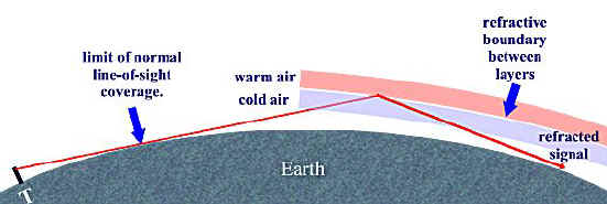
Tropospheric Refraction - Tropospheric refraction (the bending of the signal) takes place when air masses become stratified into regions having differing dielectric constants. A sharp boundary between air layers or masses is often refractive to very high frequency radio waves, bending them enough to cause their return to earth. The most common cause of air mass stratification is temperature inversion. Normally, temperature decreases at a constant rate as altitude increases. A temperature inversion occurs when a warmer layer of air sits atop a colder layer. Temperature inversions happen for a variety of reasons; when a warm air mass overruns a cold air mass, when solar heating occurs above a cloud layer, or when surface air rapidly cools after sunset. There are many other mechanisms that cause temperature inversions, but these are some of the most common. Sharp transitions in the water-vapor content of adjacent air masses also brings about signal refraction. When warm, dry air runs into cold, wet air (as is often found along the southern and western edges of stable, slow moving air masses), the signal refraction boundary is enhanced by both the temperature and the humidity differences. Depending on the quality of equipment used, signal distances via tropo-refraction are pretty much the same or slightly longer than those obtainable from tropo-scatter. The difference between tropo-scatter and tropo-refraction shows up more in the signal strength, quality and the number of receivable signals rather than an increase in signal path distance. Signals enhanced via tropo-refraction are often fairly strong and stable, and suffer less from flutter and fading. Tropospheric refraction is most likely to occur in the early morning hours just after dawn, and the early evening hours just after sunset. It's least likely to occur at mid-day when the atmosphere is most stable. However, the passage of weather fronts, storms, etc. can produce tropo-refraction at any time of the day or night.
Tropospheric Ducting - This is where things start getting interesting. Temperature inversions with very well defined boundaries can form from a few feet to a few hundred feet above the surface of the Earth. The boundary layer and the Earth form the upper and lower walls of a "duct" that acts much like a metallic wave guide or "signal pipe." In the tropics and over large bodies of water, this type of inversion is quite common, and stable ducts can remain in tact for days on end. Signals trapped in the duct follow the curvature of the Earth, sometimes for hundreds or even thousands of miles. This form of ducting is responsible for fairly reliable propagation between California and Hawaii at VHF and higher frequencies.
An interesting characteristic of this form of ducting is that both the transmitting and receiving antennas must be inside of the duct to gain the maximum signal enhancement. A receiving antenna located outside of the duct will hear little or no signal from a transmitting antenna located inside the duct. While somewhat less common, ducts sometimes form between atmospheric boundary layers at much higher altitudes, with the upper boundary having an altitude as high as 10,000 feet or more. The upper refractive layer bends signals downward, while the lower refractive boundary bends the signals upward, forming a signal-trapping duct that acts much like a wave guide. Signals "get in" or are "let out" through "holes" in the bottom layer, or at the "ends" of the duct.. When this condition exists, FM band signals can travel thousands of miles. Indeed, there is no theoretical limit to the distance a signal can travel via tropospheric ducting. With respect to the receiving station, tropospherically ducted signals will usually come from a geographically selective area. A distant station may be heard in favor of a closer station. Sometimes conditions are such that multiple ducts form, bringing in distant stations from many different areas at the same time. A basic principal of radio is that the wavelength of a signal gets shorter as the frequency of the signal is increased. Because of this, the size of the tropospheric duct determines the lowest signal frequency that it can successfully propagate. This is knows as the Lowest Usable Frequency or LUF of the duct. A physically small duct, a duct with its upper and lower boundaries close together, will propagate only higher frequency signals with very short wavelengths. As the distance between the boundaries of the duct increases, the signal frequency the duct will propagate decreases. In other words, a larger duct will accommodate a lower frequency signal having a physically longer wavelength. It's possible for a duct to form that only supports signal propagation at the higher end of the FM band, while not passing signals from the lower end. The best places for tropospheric ducting are the Gulf-Coast states, the Atlantic Coast states, the Great Lakes region, and the Mississippi Valley. Tropospheric ducting is rare in mountainous regions, where the terrain effectively breaks up any ducting. For example, tropospheric ducting is almost unheard of in the Rocky Mountain region. It is most apt to occur in September and October, but can happen any time of the year. Sporadic E - This is probably one of the most interesting and exciting forms of signal enhancement for the FM DXer. Highly ionized patches or "clouds" occasionally form in the E region of the ionosphere at altitudes between approximately 50 and 70 miles. These are known as sporadic E clouds. Sporadic E clouds are usually fairly small in size. They often, but not always, travel from their point of creation to the north and northwest at speeds up to several hundred miles per hour.
It's interesting to note that after almost 70 years of study the true cause for sporadic E is still unknown. There are many different theories as to how and why sporadic E clouds form. It was once believed that the formation of sporadic E clouds was directly related to solar (sunspot) activity, and you'll still see that theory expressed in some text books even though overwhelming evidence suggests that this belief is wrong. There seems to be no correlation between the ionization level or formation of sporadic E clouds and sun spots or solar flairs - at least not in the mid latitudes away from the geomagnetic equator and poles. It was noted all the way back in the 1930s and 1940s that the formation and intensity of mid-latitude sporadic E clouds does not substantially vary over the course of the eleven year solar cycle. There is evidence to suggest that the primary cause of sporadic E cloud formation is wind shear, a purely weather-related phenomenon. Intense high altitude winds, traveling in opposite directions at different altitudes, produce wind shear. It is believed that these wind shears, in the presence of Earth's geomagnetic field, cause ions to be collected and compressed into a thin, ion-rich layers, approximately one-half to one mile in thickness. The area of these patches can vary from a few square miles to hundreds or even thousands of square miles. Along the same line is the theory that sporadic E clouds are formed in the vicinity of thunderstorms by the intense electrical activity associated with the storm. There is often (but not always) a correlation between thunderstorm activity and the formation of sporadic E clouds, enough to make this theory very tantalizing. However, strong thunderstorms often form along frontal boundaries, and intense wind sheer is usually found along the same frontal boundaries that produce thunderstorms. Yet another emerging theory suggests that sporadic E clouds are formed by concentrations of meteoric debris. Again, there is a correlation between meteor shower activity and the number and intensity of sporadic E clouds. The point is, nobody has presented a definitive explanation for how and why sporadic E clouds form. There are many excellent papers on the subject. Just enter "sporadic E" into your favorite search engine, and start reading. It's entirely possible (perhaps even likely) that sporadic E clouds are formed as the result of a combination of factors, perhaps involving wind shear, thunderstorm activity and cosmic debris. The amount by which the path of a radio signal is refracted by sporadic E clouds depends on the intensity of ionization and the frequency of the signal. For a given level of ionization, the signal refraction angle will decrease as the frequency is increased. Above a certain critical frequency, refraction of the signal will be insufficient to return it to the surface of the Earth. This critical frequency is known as the Maximum Usable Frequency or MUF. Occasionally, the intensity of Sporadic E cloud ionization increases to the point where the MUF rises into and above FM band frequencies (88 to 108 MHz). It is common for the MUF to rise up to and then stop at a particular frequency within the FM band. Distant signals will be heard below the MUF, while only local or tropospherically enhanced signals will be heard above the MUF. It has been observed over the years that the signal strength of received sporadic E signals will be greatest just below the Maximum Usable Frequency. Also, since the bending angle decreases as signal frequency is increased for a given ionization level, we can surmise that the most distant receptions will occur as we approach the MUF. In other words, an Es cloud supporting long distance skip at 100 MHz will generally produce much shorter skip distances at 50 MHz.
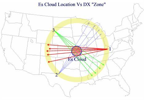
The above illustration shows a fairly typical Es cloud configuration and the associated skip zone. Three different DXers are represented by the numbers 1, 2 and 3. The Es cloud is shown as being over Eastern Kansas and Western Missouri. The yellow band is the DX zone. Using the same sporadic E cloud, a DXer in one part of the country will hear one assortment of stations while a DXer in a different part of the country will hear a completely different set of stations. If the DXers were to plot lines between their respective locations and the stations they were each hearing (as shown above), the approximate location of the sporadic E cloud will be above where the lines intersect. DXer #1, located in Lexington, KY, will hear stations in New Mexico and Colorado. DXer #2, in West Texas will hear stations in Wisconsin and Michigan. DXer #3, located in Western south Dakota will hear stations in Mississippi and Alabama. Es signal paths are usually bi-directional. In other words, if the DXer in Kentucky is hearing FM stations in Colorado, the DXer in Colorado will be able to hear stations in Kentucky. Since Es clouds often move rapidly with respect to the receiving station, the DXers will often hear a rapidly changing selection of distant signals.
This illustration shows three sporadic E clouds. Cloud #1 is more intensively ionized, and is thus capable of refracting signals at a sharper angle, producing a shorter skip distance for a given frequency. Signals being refracted by Cloud #2 are returned to Earth at a lesser angle, thus producing longer skip distances. With clouds #2 and #3 in alignment along the signal path, "double-hop" skip can occur. A sporadic E cloud producing short to medium distance skip at lower frequencies (TV channel 2, for example) is likely to produce longer skip at FM frequencies if the MUF is high enough. Note: This, as well as the other propagation mode illustrations shown here, are obviously not drawn to scale. The signal "bending" angles shown are very exaggerated. In reality, they are usually fairly slight angles. The maximum distance for a single-hop sporadic E propagated signal is approximately 1,500 miles. However, if multiple, sufficiently ionized patches exist in a line along a particular signal path, it's possible for a given signal to reflect off the surface of the Earth after the first hop and get refracted back to Earth by a second sporadic E cloud. This can extend the range of E-layer propagated signals out to 3,000 miles and beyond. Statistically speaking, the "average" skip distance for sporadic E propagated FM DX seems to be between 950 and 1,200 miles. Received single-hop E-layer propagated signals are often as strong as local signals. Indeed, I have witnessed more than one situation where a local station was completely "covered" by a distant one, only a few miles from the local station's transmitter location (that's when they call the engineer to see if he can "fix" the problem). Since the surface of the Earth is not a very good signal reflector, multi-hop E-layer propagated signals will usually be weaker than single-hop signals, and are often covered by signals coming from stations in the single hop zone. If the mid-point of a double-hope happens to be on water (such as the ocean), the signals will be stronger and the there will likely be no interference from mid-point stations (unless someone happens to be operating an FM broadcast station aboard a ship!). In the northern hemisphere, seasonal sporadic E season peaks occur during the months of May, June and July. An additional minor peak often occurs in late December around Christmas time when the Sporadic E season is at its summertime peak in the southern hemisphere. One theory to explain this phenomenon is that intense sporadic E clouds formed in the vicinity of the equator manage to hold their configuration as they drift toward the north and northwest, thus producing our short December sporadic E DX season. The best time of day for sporadic E seems to be mid morning and mid afternoon. However, sporadic E DX can happen at anytime, day or night, and can pop up any time of the year. Sporadic E DX usually lasts from a few minutes to a few hours. However, I've seen it last several full days and nights, causing a great lack of sleep! Aurora Effect - During periods of high solar and geomagnetic activity, aurora or "northern lights" may be present. FM signals can be returned to Earth from the auroral curtain. However, the constantly varying intensity of the aurora and its highly variable reflectivity give auroral propagated signals a fluttery quality. The flutter will usually be in the range of 100 Hz to 2,000 Hz, producing a "buzz" in the received signal. In some cases, this effect can be so strong, normal voice or music modulation ends up becoming distorted to the point of unintelligibility. In the northern hemisphere, auroral propagated signals will generally come from the north, regardless of the true direction of the transmitting station.
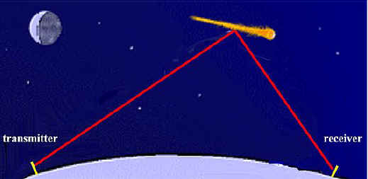
The theoretical maximum distance for Auroral enhanced signals is about 1,300 miles. 200 to 800 miles is typical. High quality, very sensitive, receiving equipment is required for this DX mode. Meteor Scatter - This interesting form of enhancement results from signals bouncing off of the intensely ionized trails of meteors entering and "burning up" in the E region of the ionosphere. The strength and duration of meteor scatter signals decreases with increasing frequency. Thus, the effect is much more pronounced at the lower FM band frequencies than at the upper end of the band. Meteor scatter can be heard anywhere, anytime of the day or night. However, bursts are more plentiful around dawn, and during known major meteor showers.
Meteor scatter is characterized by a sudden, short burst of a distant,
strong signal. The length of the burst depends upon the length and
intensity of the ionized meteor trail. They can be as short as a fraction
of a second, producing a short "ping" at the receiver. Larger
meteors, or meteors entering atmosphere at a glancing angle, have been known to
produce signal bursts lasting up to several minutes. If you try, you'll
hear many meteor scatter signals. However, you have to be lucky to
actually catch a station identification at exactly the same instant the meteor
burst occurs. High quality equipment helps, but meteor bursts can even be
heard on the "average" car radio if you know what to listen
for.. Since the more common tropospheric enhancements are weather related, it's important to pay attention to conditions that produce the DX you hear. After careful observation, you'll probably see various patterns emerge, such as temperature and barometric pressure, the position of weather fronts, the locations of high and low pressure areas, wet/dry boundaries, and so on. |


About Me | Contact Info Index | News Index | Search Index | My Hobbies Index
This
document maintained by [email protected].
Material Copyright © 2002 K5JMP