K3XY
APRS DIGIPEATERS
Both K3XY
digipeaters operate on the national APRS frequency 144.39 MHz with alias
identifications of WIDE, RELAY and TRACE. Each station employs
a PacComm Tiny-2 TNC with Release
4.0 firmware and a Motorola MAXAR mobile-type transceiver, set to 20 watts
output power.
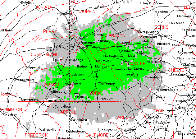
The
K3XY-2 APRS digipeater is located about three miles northeast of
York, PA at the W3HZU Keystone
VHF Club station. The antenna elevation is about 950 feet above
mean sea level, with line-of-sight coverage to most of York County and
the surrounding area, including much of the capital city of Harrisburg.
Many thanks to the Keystone VHF Club for providing space at their fine
facility.
K3XY-2
COVERAGE MAP
GREEN
=
90% MOBILE COVERAGE, GRAY
=
50% MOBILE COVERAGE
Click
here for detailed maps and recent beacon received from K3XY-2 via Internet
gateway
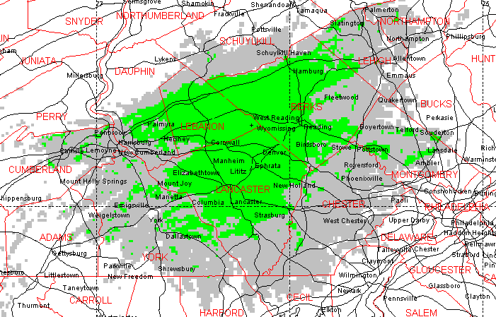
The K3XY-3
digipeater is located about two miles southeast of Newmanstown, PA in the
eastern corner of Lebanon County, atop South Mountain at "Eagle's Peak",
the highest point of land east of the Susquehanna River and south of Blue
Mountain. A new antenna was recently installed... K3XY-3
now employs a Decibel Products DB224
commercial-grade dipole array, mounted 70 feet above ground level and 1410
feet above mean sea level, offering line-of-sight service to Lebanon, Lancaster,
and Reading, PA. The 442.4 MHz N3KZ/R
"University of Pennsylvania" voice repeater, which is co-located, uses
a seperate antenna atop the tower. The site, provided courtesy of
Temple
University Public Radio, is the transmitter location of FM broadcast
station WRTL, 90.7
MHz, licensed to Ephrata, PA.
K3XY-3
COVERAGE MAP
GREEN
=
90% MOBILE COVERAGE, GRAY
=
50% MOBILE COVERAGE
Click
here for detailed maps and recent beacon received from K3XY-3 via Internet
gateway
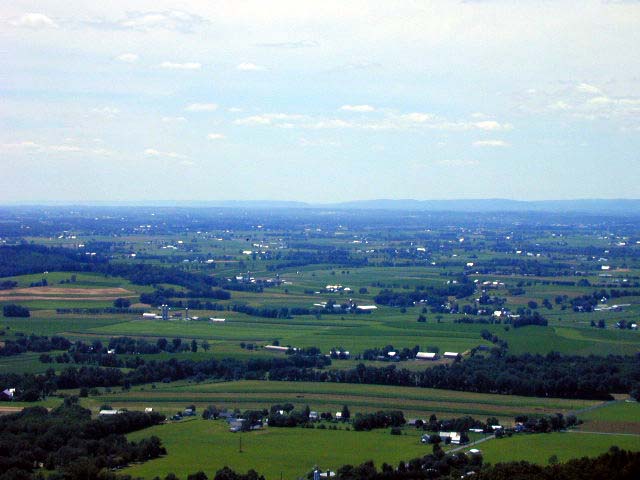
A view of the Lebanon
Valley taken from the tower... looking west-northwest from the K3XY-3
antenna, which is nearly 1000 feet above those green fields. The
aptly-named ridge in the background is Blue Mountain... Indiantown Gap
is visible in the center and the Susquehanna River gap (about 40 miles
away, north of Harrisburg) is just visible at the left edge.
Photo by Jeff DePolo WN3A.
E-MAIL
K3XY
With Comments, Questions and Suggestions
HOME