Good Afternoon:
I just completed a conference call with NC Emergency Management and the National Weather Service concerning the upcoming Winter Weather. The NWS is now issuing a WINTER STORM WARNING for our area.
The highlights of the call are as follows:
HEAVY WET SNOWFALL IS EXPECTIED ACROSS THE AREA
A line from Mocksville to Rutherford County is the line that is established as a dividing line
Points north of that line can expect to receive 8-12 inches of snow
Points south can expect 6-10 inches of snow along with a brief change from snow to freezing rain back to snow
Precipitation should begin late Friday morning in our area and change to very heavy snowfall after lunch
Snow will remain heavy throughout the night tapering off on Saturday morning.
The snow will be the HEAVY WET variety
Winds are expected to increase to 10-15 MPH with gust to 30 MPH (which could result in heavy damage to trees from the heavy snow)
Temperatures are not expected to rise much and the snow will linger
They are expecting 16 plus inches in the mountains
Another system will be moving into the area on Christmas Eve (to early to tell what type precip it will be)
This is the highlights (if you can call it that) of the conference call. It seems the further north you get in the county, the heavier snowfall you will get.
We are establishing a WEBEOC event "Winter Storm – December 2009"
We will be monitoring this situation and let you know of any updates!
David W. Martin, Director
Iredell County
Emergency Communications, Operations & Management
Dennis L. White
N4WHK
ARES EC Iredell County
NC WX Spots Coordinator
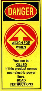 At
approximately 8:40 PM on October 12, a man, woman
and their 15 year old son were killed while trying
to erect a 50 foot vertical antenna at the home of
the man's mother, Barbara Tenn, KJ4KFF, in Palm Bay,
Florida. The deceased were not licensed amateurs.
According to police reports, Melville Braham, 55,
Anna Braham, 49, and their 15 year old son Anthony
were putting up an antenna -- Tenn's second -- at
night when they lost control of the antenna and it
crashed into nearby overhead power lines. The impact
sent 13,000 volts of electricity through the pole
that the three were holding. A family friend, a 17
year old boy, was on the roof at the time of the
accident. He and the couple's daughter, who was in
the house at the time, were not injured. Click
At
approximately 8:40 PM on October 12, a man, woman
and their 15 year old son were killed while trying
to erect a 50 foot vertical antenna at the home of
the man's mother, Barbara Tenn, KJ4KFF, in Palm Bay,
Florida. The deceased were not licensed amateurs.
According to police reports, Melville Braham, 55,
Anna Braham, 49, and their 15 year old son Anthony
were putting up an antenna -- Tenn's second -- at
night when they lost control of the antenna and it
crashed into nearby overhead power lines. The impact
sent 13,000 volts of electricity through the pole
that the three were holding. A family friend, a 17
year old boy, was on the roof at the time of the
accident. He and the couple's daughter, who was in
the house at the time, were not injured. Click