Today's Discussion
POSTED: September 27, 2004 2:25 a.m.
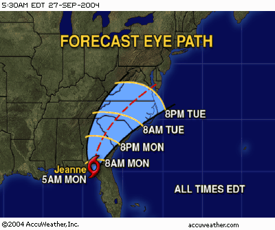
Jeanne continues to slowly weaken as it moves northward across the northern portion of the Florida peninsula towards Georgia. As of 2 AM EDT, winds remain at 50 miles per hour, and the storm was moving to the north at 12 miles per hour. Jeanne will weaken to a tropical depression Monday morning as it moves across southern Georgia. However, while the winds will be relatively weak inland as it travels north across the Carolinas, Virginia and the Delmarva, winds at the coast may still gust upwards of 50-60 miles per hour in the Carolinas and 40-50 miles per hour from Virginia north to New Jersey. The biggest threat, however, is heavy rain and severe weather. The heaviest rain will likely fall along and just west of the track as easterly upsloping winds ahead of Jeanne squeeze moisture out of the tropical airmass it is bringing northward. Meanwhile, severe weather, especially tornadoes, are likely to the east of the track as thunderstorms develop in the tropical airmass. Further north, the storm will be just off shore, so heavy rains are likely across the major cities of the Northeast. Fortunately, many of those areas were spared from heavy rain during the passage of Frances and Ivan, but heavy rains will still pose a serious flooding risk along the I-95 corridor.
Tropical Storm Lisa is a much weaker storm and remains far from land. As of 11PM EDT, Lisa had maximum winds of only 50 miles per hour and was moving towards the north at 6 miles per hour. This system will continue to move into the open Atlantic and eventually become extratropical as it gets caught up in the westerlies. No turn towards the United States, or any land, is expected while the system is tropical. Its extratropical remnant may eventually affect Europe in 1-2 weeks.
The pattern is still one that warrants concern for development this week in the southern Gulf or Caribbean, though at this time, there is no evidence of development.
|


