From command line in the following directory /etc/svxlink/svxlink.d then using the following command
sudo nano ModuleMetarInfo.conf amend the existing script as per the listing below...
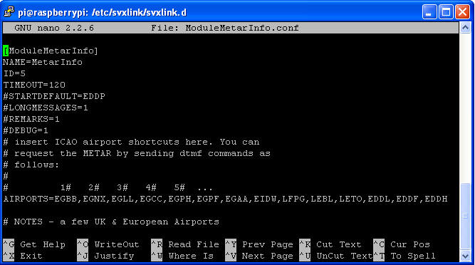
Note in the listing below, the blue highlighted text indicates what is to be amended to the existing Logic.tcl script...
[ModuleMetarInfo]
NAME=MetarInfo
ID=5
TIMEOUT=120
#STARTDEFAULT=EDDP
#LONGMESSAGES=1
#REMARKS=1
#DEBUG=1
# insert ICAO airport shortcuts here. You can
# request the METAR by sending dtmf commands as
# follows:
#
# 1# 2# 3# 4# 5# ...
AIRPORTS=EGBB,EGNX,EGLL,EGCC,EGPH,EGPF,EGAA,EIDW,LFPG,LEBL,LETO,EDDL,EDDF,EDDH
# NOTES - a few UK & European Airports
#
# EGBB BHX Birmingham International Airport - Elevation 327 feet Latitude 52° 27' 14.04" N Longitude 1° 44' 52.91" W
# EGNX EMA East Midlands Airport - Elevation 306 feet Latitude 52° 49' 51.96" N Longitude 1° 19' 41.02" W
# EGKK LGW London Gatwick Airport - Elevation 202 feet Latitude 51° 8' 53.17" N Longitude 0° 11' 25.00" W
# EGLL LHR London Heathrow Airport - Elevation 83 feet Latitude 51° 28' 14.16" N Longitude 0° 27' 42.99" W
# EGGW LTN London Luton Airport - Elevation 526 feet Latitude 51° 52' 28.92" N Longitude 0° 22' 6.00" W
# EGSS STN London Stansted Airport - Elevation 348 feet Latitude 51° 53' 5.99" N Longitude 0° 14' 6.00" E
# EGCC MAN Manchester Airport - Elevation 257 feet Latitude 53° 21' 13.32" N Longitude 2° 16' 29.82" W
# EGPH EDI Edinburgh Airport - Elevation 135 feet Latitude 55° 57' 0.00" N Longitude 3° 22' 21.00" W
# EGPF GLA Glasgow International Airport - Elevation 26 feet Latitude 55° 52' 18.84" N Longitude 4° 25' 59.02" W
# LFPG CDG Charles de Gaulle International Airport - Elevation 392 feet Latitude 49° 0' 46.07" N Longitude 2° 32' 60.00" E
# LEBL BCN Barcelona International Airport - Elevation 12 feet Latitude 41° 17' 49.56" N Longitude 2° 4' 42.46" E
# LETO TOJ Madrid-Torrejón Airport - Elevation 2,026 feet Latitude 40° 29' 48.12" N Longitude 3° 26' 45.13" W
# EDDL DUS Düsseldorf International Airport - Elevation 147 feet Latitude 51° 17' 22.20" N Longitude 6° 46' 0.41" E
# EDDF FRA Frankfurt International Airport - Elevation 364 feet Latitude 50° 1' 35.05" N Longitude 8° 32' 35.27" E
# EDDH HAM Hamburg Airport - Elevation 53 feet Latitude 53° 37' 49.45" N Longitude 9° 59' 17.63" E
# EGAA BFS Belfast International Airport - Elevation 268 feet Latitude 54° 39' 27.00" N Longitude 6° 12' 56.99" W
# EIDW DUB Dublin Airport - Elevation 242 feet Latitude 53° 25' 16.68" N Longitude 6° 16' 12.25" W