![]() I have always been wondering how IOTA chasers determine the island location from a reference number. Some island groups include over 100 islands and cover significant areas.
I have always been wondering how IOTA chasers determine the island location from a reference number. Some island groups include over 100 islands and cover significant areas.
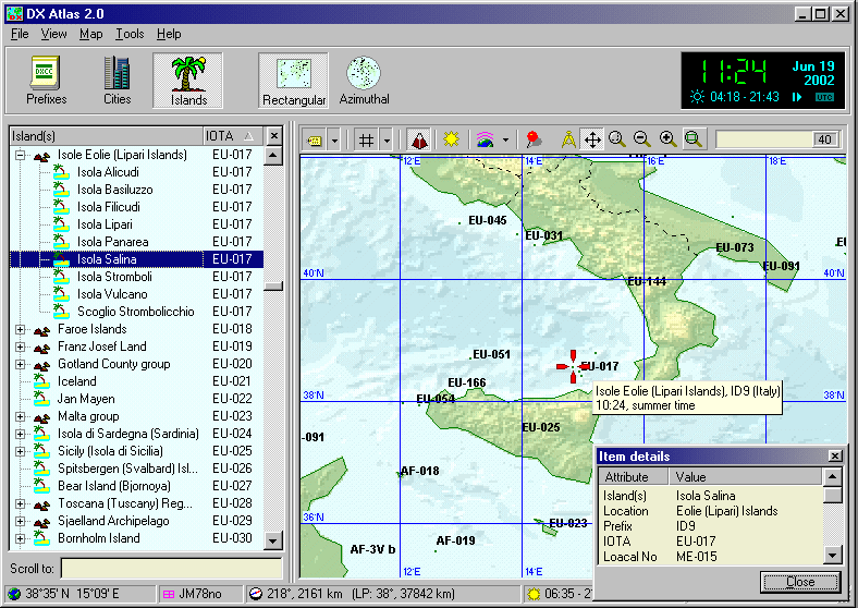
![]() Unfortunately, there are no geographic maps for radio amateur island awards, or at least I have never heard of such maps. I started collecting island coordinate data years ago, and later I decided to create a complete geographic database with coordinates of all islands that count for numerous island awards. In addition to island names and coordinates, I included the reference numbers of the islands according to several island awards, such as IOTA, IIA, DIP, RRA, to name a few. The database can be used to quickly locate an island, and also provides additional information (ref. ID, country, call area, and activation history).
Unfortunately, there are no geographic maps for radio amateur island awards, or at least I have never heard of such maps. I started collecting island coordinate data years ago, and later I decided to create a complete geographic database with coordinates of all islands that count for numerous island awards. In addition to island names and coordinates, I included the reference numbers of the islands according to several island awards, such as IOTA, IIA, DIP, RRA, to name a few. The database can be used to quickly locate an island, and also provides additional information (ref. ID, country, call area, and activation history).
![]()
![]() When Afreet Software released their DX Atlas, this gave a new dimension to my project. The database that was partially ready, now could be overlaid on the World map to further accelerate the search. I changed the database format and turned it into an Add-On Database for the DX Atlas software.
When Afreet Software released their DX Atlas, this gave a new dimension to my project. The database that was partially ready, now could be overlaid on the World map to further accelerate the search. I changed the database format and turned it into an Add-On Database for the DX Atlas software.
![]() DX Atlas is surprisingly fast in processing big data files. Though the standard island list included with the program is only 100 Kb in size, DX Atlas still works fine with my database that is 20 times bigger !!!
DX Atlas is surprisingly fast in processing big data files. Though the standard island list included with the program is only 100 Kb in size, DX Atlas still works fine with my database that is 20 times bigger !!!
![]() There is one more opportunity to improve quality of some programs. So for example, appearance of the program DXView additional maps considerably will improve. Judge, what from maps is looked better. And you see it is possible to substitute maps and greater size!!!
There is one more opportunity to improve quality of some programs. So for example, appearance of the program DXView additional maps considerably will improve. Judge, what from maps is looked better. And you see it is possible to substitute maps and greater size!!!
 | ||
![]() Except for the basic map in the program DXView the very primitive maps of countries-territories are used which can be replaced with best.
Except for the basic map in the program DXView the very primitive maps of countries-territories are used which can be replaced with best.
![]() The same completions can subject and some other programs (for example: WLOG2000).
The same completions can subject and some other programs (for example: WLOG2000).
![]()
![]() Hope for your support and participation!!!
Hope for your support and participation!!!
![]()
2001, EU6TV
Nikolay Sukhorukov
Vitebsk, Rep. of Belarus
)