| Clipperton Island Factbook |
This information was borrowed from the 1998 CIA World Factbook.
| Clipperton Island |
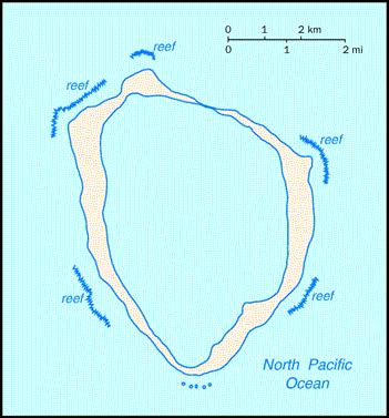
Location: Middle America, atoll in the North Pacific Ocean, 1,120 km southwest of Mexico
Geographic coordinates: 10.17 N, 109.13 W
Map references: World
Area:
total: 7 sq km
land: 7 sq km
water: 0 sq km
Area—comparative: about 12 times the size of The Mall in Washington, DC
Land boundaries: 0 km
Coastline: 11.1 km
Maritime claims:
exclusive economic zone: 200 nm
territorial sea: 12 nm
Climate: tropical, humid, average temperature 20-32 degrees C, rains May-October
Terrain: coral atoll
Elevation extremes:
lowest point: Pacific Ocean 0 m
highest point: Rocher Clipperton 29 m
Natural resources: none
Land use:
arable land: 0%
permanent crops: 0%
permanent pastures: 0%
forests and woodland: 0%
other: 100% (all coral)
Irrigated land: 0 sq km (1993)
Natural hazards: subject to tornadoes
Environment—current issues: NA
Environment—international agreements:
party to: NA
signed, but not ratified: NA
Geography—note: reef about 8 km in circumference
Population: uninhabited
Country name:
conventional long form: none
conventional short form: Clipperton Island
local long form: none
local short form: Ile Clipperton
former: sometimes called Ile de la Passion
Data code: IP
Dependency status: possession of France; administered by France from French Polynesia by a high commissioner of the Republic
Legal system: NA
Diplomatic representation in the US: none (dependent territory of France)
Diplomatic representation from the US: none (dependent territory of France)
Flag description: the flag of France is used
Economy—overview: Although 115 species of fish have been identified in the territorial waters of Clipperton Island, the only economic activity is a tuna fishing station.
Ports and harbors: none; offshore anchorage only
Military—note: defense is the responsibility of France
Disputes—international: none
Last updated on September 20, 1999