December 31, 2001
Hi Class,
I hope you had a good Christmas vacation. During the time that you were on vacation we have had excellent weather and were able to conduct most of the planned surveys. I am writing this report on December 31. With the conclusion of today's mission, we have finished all of our survey work. In fact, by the time you read this report our group may be in route to the U.S.
A typical survey day begins with a ride from the base at McMurdo to Williams Field about 7 miles away. The airfield is located on the McMurdo Ice Shelf. The last 4 of these miles of the trip to the airport is over a highway made of compacted snow on which the vehicles drive. During good weather we ride from McMurdo to the airport in vans equipped with 4-wheel drive, but two weeks of unusually warm weather that we have had has created problems with compacting the snow near the edge of the land in an area called the transition zone. So lately we have been riding in a Delta which is a vehicle especially equipped for operating under such conditions.
At the airport the runways and parking ramps for the aircraft are also compacted snow. All of the aircraft operate with skis rather than with wheels. The airport is a fairly busy place each morning with a lot of activities along the row of temporary facilities and on the parking ramp. On many days two or more of the C-130) aircraft are loaded with supplies for the Scott-Amundsen Base at the South Pole located some 750 nautical miles (1,400 kilometers) to the south. (If you look closely, you can see the sled loaded with supplies which are about to be loaded onto the C-130.) These large cargo aircraft are the only way to get supplies to Scott-Amundsen Base. In fact, the U.S. is enlarging the base, so in addition to the usual supplies, these aircraft must carry materials for constructing the new base.
Each day when we arrive at the airport we initially begin by warming up Airborne Topographic Mapper (ATM), the scanning laser sensor that we use to do the surveys. The ATM is flown on a two-engine Twin Otter aircraft. We also begin recording data from Global Positioning System (GPS) receivers. A GPS receiver acquires signals from a constellation of earth orbiting satellites from which it can develop a solution that accurately provides the position of the receiver. We operate a GPS receiver at a fixed location outside of our laboratory at the airport where the antenna is mounted on a tripod. A GPS receiver is also flown on the aircraft with the antenna is fastened to the upper fuselage (top) of the plane. The GPS receiver located on the aircraft is utilized to acquire the approximate position of the aircraft
during the flight. This position has some uncertainties at the 10 to 35 foot level (3 to 10 meter) largely due to propagation errors as the satellite signals travel through the earth's atmosphere. Fortunately these same errors are also found in the position of the fixed antenna mounted on the tripod. Since we already know the position of the fixed antenna, these temporary variations in position can be used to correct the position of the aircraft during post flight data processing. Besides knowing the exact distance from the ATM sensor to the ground or ice and the corrected position of the aircraft antenna, we need to know the attitude of the aircraft, that is the amount of roll (side-to-side), pitch (nose-to- tail), and heading (pointing direction). This aircraft attitude information is provided by an Inertial Navigation System (INS) that is flown onboard the aircraft.
Following the warm up and instrument calibration on the ground, the aircraft is prepared for take off. The most unusual thing about this is that during the12-hour period since the aircraft was parked the skis have frozen to the compacted snow. They must be loosened by placing a block of wood next to each ski and hitting the block with a sledge hammer. To further break the grip of the skis to the compacted snow, the aircraft engines are brought up to high power for an instant causing the aircraft to lurch forward. We then taxi to the runway and takeoff for the survey destination of the day.
Each day we have a section of interest to survey that is generally 4 or more nautical miles in width (7 kilometers) and 20 to 30 nautical miles in length (32 to 48 kilometers). The aircraft is able to survey a swath of about 1,600 feet (490 meters) on each pass. Therefore the aircraft must be flown repeatedly back and forth within the survey site. Each time the aircraft moves over by about 80% of the swath width or 1,280 feet (400 meters). Picture it like mowing a lawn. After each pass you move the lawn mower over to mow the next swath of grass. In order to guide the aircraft, a navigator in the sensor compartment of the aircraft operates a display of the aircraft position that is fed by the GPS receiver. A copy of the same display is routed to a flat screen display in the cockpit that is viewed by one of the pilots. An example of the cockpit display during the middle of a mission shows lines that have been flown in red and the current line being flown by the pilot in blue. (Notice the overlap between the current scan line and the earlier scan line is about 20%.) As the mission progresses the screen begins to fill until finally at the end of the mission, the entire survey area is filled with red scan lines. (The screen shows Mt. Discovery at a point where the survey has just been completed.)
Meanwhile, an engineer carefully controls and watches (monitors) the performance of the ATM scanning laser sensor. Adjustments must be made to accompany changes in the reflectivity (albedo) of the ground and ice surfaces and differences in the altitude above ground level (AGL) of the aircraft. The aircraft is so valuable to the National Science Foundation's Antarctic Program that they required the surveys to be accomplished in a reasonably quick time period so that the aircraft can be used on other projects. In order to meet this scheduling requirement, the ATM group formed two survey teams, each flying one mission per day. During the period from December 18 through December 29 two 4-hour missions were flown nearly every day except for Christmas Day when the airfield was closed.
The areas that we were asked to survey are quite varied both in their potential scientific use and in their natural settings. The interest of NASA investigators is primarily in obtaining surveys of the Dry Valleys for use in calibrating the Geodetic Laser Altimeter Sensor (GLAS), a satellite to be launched in mid 2002. Some geologists from the U.S. Geologic Survey (USGS) are also interested in the Dry Valleys for a variety of studies. Other areas requested by (USGS) scientists included volcanoes and volcanic features that are fairly common in the section of Antarctica in the vicinity of the U.S. base at McMurdo and still others are interested in studying glacial surfaces.
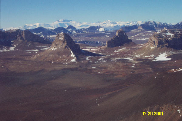
The Dry Valleys are a particularly interesting and beautiful region. Sections such as the Wright Valley are surrounded by buttes and canyon walls composed of exposed sandstone with igneous intrusions (from ancient volcanic activities) along dykes. A stark contrast is evident between the light sandstone and dark igneous intrusions. The valley is surrounded numerous glaciers that flow through smaller valleys flanking Wright Valley. The most spectacular of these glacial features is the Ice Fall Labyrinth at the upper end of Wright Valley. Lofty snow capped peaks from mountains (Nunataks) can be seen in the distance. The Dry Valleys are situated in a very dry (arid) region of Antarctica receiving very little snowfall. At any time of the year, but especially in the Austral winter, strong, dry winds sink from the ice sheet covering the inland region and evaporate what little snow exists. These winds, known as Katabatic winds, are some of the strongest in the world.
The glaciers are of interest themselves for studies of their movement and net changes in thickness, but they often provide additional information about the underlying rock (geological) formation. Volcanoes such as Mount Erebus, Mount Discovery, and Mount Morning are also of interest to geologists.
During the field activities, considerable efforts are made by other scientists and engineers to check the quality of the data and to locate any gaps between survey lines. The data is processed following each mission. Temporary products are produced which permit scientists to assess the goodness of the data. (The figure shows the elevation of Taylor Valley represented with colors. The bluer colors are lower elevation and the redder colors are higher elevation.)
As the field deployment draws to a conclusion, the team draws a sense of satisfaction, having deployed to such a remote location, installed instruments in a different aircraft, planned and executed successful missions in a strange locale with challenging variations in the height, and accomplished nearly all of the requested surveys. These sensors will be removed and shipped back to NASA's Wallops Flight Facility for use in similar investigations over the ice sheet of Greenland during the spring of 2002.
Please send any questions that you may have to us, and we will attempt to answer them.
Regards,
Robert Swift