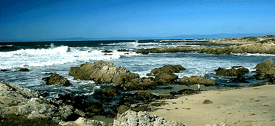
Looking North near Asilomar on the Monterey Peninsula
For scale, note the small
boy at the edge of the sand about 1.5 inches in from the lower right corner
of the picture. The waves in this picture are running about 6 to 8 feet
high.
Low on the horizon, some 20-25 miles distant, are the
Santa Cruz Mountains. While not evident at this distance, these mountains
are 1500-4000 feet high with Loma Prieta being the highest peak. It
is visible about an inch from the right edge of the photo.
If it was visible at this distance, Santa Cruz
would be across the bay at the left edge of the photo and Watsonville (my
home town) would be located roughly in front of Loma Prieta. San
Jose is located on the other side of the mountains in the center of the
picture. About 100 miles north of this location is the city of San
Francisco. Big Sur is a half hour to 45 minute drive south
along the rugged cliff hugging route of Highway 1.
Ham VHF/UHFers Note: Loma Prieta is home to quite a number of FM and TV stations as well as multitudes of two way and microwave facilities. It has a commanding view of both the San Francisco and the Monterey Bay Area. Nearby, though hidden from view behind Loma, is Mt. Umunuhm, also a great communications site in directions not blocked by Loma Prieta. This is the site of the Baycom repeater, WA6YCZ, one of the pioneer systems in the Bay Area with 2M through 10 GHz inputs and outputs, links, etc. There are roads accessing the ridge below these peaks though access roads to the summits are restricted.
The other communications hot spots in the area are Mt. Toro, just south of our viewpoint and Fremont Peak, which is out of the picture to the right just east of Salinas. Both of these mountains are accessible by paved road though I'm not sure of the present status of access restrictions to Mt. Toro.