
I had just finished washing Kentucky's "Flood '97"* mud off my pack after two weeks of work in Louisville, and was trying to grab a quick bite of supper when a glance out the west window revealed two funnels heading toward us. No, those weren't some type of optical illusions caused by the hilly landscape and scud clouds, they were the real thing! Even though I had never been able to go to the Midwest to chase twisters. now it appeared they were in central Kentucky and coming after me!
The first two days of March 1997 had brought over 12 inches of rain to our area due to the training of storms along the Ohio River Valley. By Monday, March 3, the Red Cross was asking for help to begin damage assessment in the Radcliff and West Point areas. The problems were caused by ponding and urban flooding, for the Ohio river and its larger tributaries had not yet had time to rise significantly. Two days were spent providing communications for the Red Cross, but little was needed. From similar experiences in Michigan, it now appeared that this might become a major flood event. We decided to try to catch up on some personal work and see what the future needs would be.
Urban flooding and ponding had been the initial problems. As the water continued its runoff, the rivers began to rise. Eventually this came to be considered the seventh largest flood for the Ohio River, far below the flood of 1937. However, in some locations, especially along some of the smaller rivers, the flood would be much worse. Falmouth, south of Cincinnati, Ohio on the Licking River, was destroyed as a town. Many other communities in Kentucky and Indiana suffered major damage. As expected, on the evening of 14 March we received a call from the Kentucky Baptist Disaster Relief to assist in the clean up, "...in whatever city you want to work."
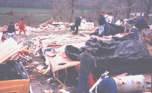
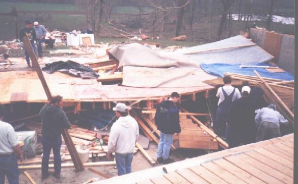
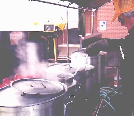 We spent the first few days of the next two weeks opening hundreds of cans of food for the kitchen facilities in Louisville. (During the month of March, 69,096 hot meals were served). Then I was assigned to a "mudout" team which consisted of 3 to 15 people, depending upon the difficulty of the job. Not only were basements flooded, many houses near the rivers were flooded nearly to the ceiling of the first floor and a few well into the second floor!) Most people didn't have flood insurance (many were not eligible for it). It was our job to carry out all of the waterlogged furniture (and every house had at least one refrigerator or freezer in the basement),
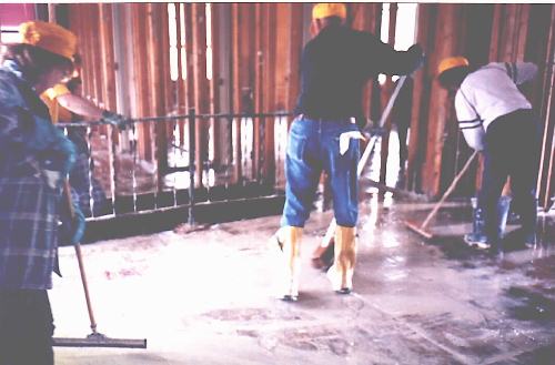 cut the carpets into strips and drag it out, remove the plasterboard from the walls, wash off the mud with a power sprayer, then disinfect the inside frame and floor with a chlorine solution. In some places near the Ohio River, houses that had been built high above the ground not only were flooded, but had as much as four inches of mud in them. This had to be shoveled out and the floor blasted with a 1½ inch fire hose before the cleaning could continue. 397 of these jobs were completed; the quick ones took about two hours, the big ones required two or more days.
This was the "entertainment" for my wife Lora (WD8LPN) and me during the last two weeks of March.
 Things were winding down and we had to started our income tax work, so Friday March 28 was to be my last day with the Disaster Relief Teams. I changed out of my muddy clothes before leaving Louisville because I had two quick stops to make on the way home. The weather still did not appear threatening, but we had been expecting the possibility of severe thunderstorms. That morning the Weather Channel had mentioned a cap over our area. This is the first time I had ever heard a cap mentioned for this area as part of a severe weather forecast. By the time I had left Louisville that Friday afternoon, reports of high winds were conning in from western Kentucky.
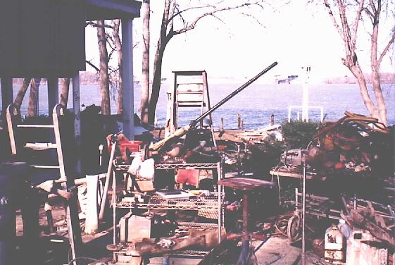
The Ramcharger had been loaded not only with extra communications gear, tools, and cameras, but also with a number of layers and changes of clothes. The weather had been very changeable, and we never knew from one day to the next what we would be doing. I had been riding to the jobs in one of the Disaster Team's Ford F-350 trucks, so I had crammed the personal equipment and extra clothing that I would most likely need that day into a back pack which rode on my muddy lap. By now it, too, was covered with mud and was a complete mess. The first aid pack, the last roll of transparency film (being shot for an upcoming class), walkie-talkie, cell phone, and extra breathing masks had all been pulled from the bottom of the pack that day. So while Lora fixed a quick supper, the Ramcharger was partially unloaded and the pack was emptied and hosed down. The local weather net was in operation, but the sky was a featureless gray. Due to the moisture and terrain, there was nothing of interest to see here. About 1845 EST we sat down to grab a welcome bite to eat while monitoring the weather net on the walkie talkie.
"I have a funnel over the Movie Palace and I think it may have touched down. I think I see debris!" came the unexpected report to the weather net. I turned and looked out the west window and saw not one but two funnels heading our way! "I confirm!" I shouted into the walkie talkie as Lora called to one of the dogs and started toward the basement door (located outside of the house). One funnel was a smooth funnel-shaped cloud aloft; the other was a small, ragged rope. The smaller funnel quickly dissipated while the other lasted only a couple of minutes longer. Watching the now ragged-looking clouds skirting past just to our northwest, two more small, tattered funnels tried to form but quickly vanished. Two wall clouds were present, one rotating as though it would spin out another funnel at any time. Two more possible small funnels were seen as the cell went over the northern horizon, neither one from either of the wall clouds. The larger funnel we had seen (or, more likely, another funnel from the same part of the storm) had touched down near Rineyille and followed a seven mile path to Colesburg doing Fl damage to several mobile homes, barns, and an apartment complex.
By now the three Louisville television stations, the local weather net, the scanner, and NOAA Weather Radio were all going wild, making it impossible to keep up with the many funnel reports that were coming in from several different areas. At about 1904 EST the strongest tornado of the day touched down just outside of Bonnieville. For the next 20 minutes it chewed a path through the countryside of Hart and Larue Counties, completely leveling many of the structures it struck before lifting a few miles past Magnolia. With so many tornado warnings, funnel reports, and radar reports flying over the airwaves, it is not known who first reported this tornado or if there were any specific warnings given for it before it had lifted The first report we heard was when K4YZU reported a large tornado on the ground with a lot debris at Magnolia (near the end of its path). The weather net control station was on the telephone with the Louisville NWS office at that moment, so they received the information immediately. But this was too late for one family, as we were to learn later. It had already become a killer.
 As this tornado was leaving the scene north of Magnolia, the cell spawned a second funnel south of the first. This one, rated at F2, cut across the corners of three counties doing an estimated $100,000 in damage. Fortunately, most of the path was in open country. But about an hour later another strong F3 tornado touched down in the Cane Valley area near Columbia, cutting a 10-mile path across northern Adair County and doing damage to a number of houses, mobile homes, and churches. And at approximately the same time in the same general area, an F2 funnel struck to the southwest of Columbia near Summer Shade in Metcalfe County doing an estimated $400,000 damage. A 28 year old woman was killed and three family members seriously injured when they were thrown from their mobile home.
More unconfirmed funnel and tornado reports were coming in. The weather system was now moving into the area covered by the Lexington NOAA Weather Radio and out of the effective coverage of the Louisville TV stations' weather radars, so timely information was becoming more difficult for us to obtain. (Due to the "modernization and improvements," the Lexington NWS office has been closed, with Louisville now covering that area). By this time the Larue County EMS had notified Hardin County that they were sending fire and EMS units to the Magnolia area as they had considerable damage.
 First reports were sketchy, indicating one fatality and about 5 injuries, houses and barns destroyed, and a large dairy farm completely wasted. The Red Cross, which had just been shutting down flood operations in Louisville and Stithton, was asked to set up a shelter at Magnolia for an unknown number of victims. When Leon, N4TFK (a firefighter who had spent all of his "spare time" for the past month at the Red Cross shelter at Stithton Baptist Church) arrived at Magnolia, he reported that no extra help was needed that night. However, survey teams would be needed next morning.
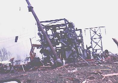 Early the next morning (Saturday), several of us left the Elizabethtown area for Magnolia. As we approached Magnolia, the local electric company closed the only direct road into town to begin their work. A small substation beside the road was wrapped in sheet metal ripped from barns and sheds, and several high tension towers and wooden power poles were flattened. Thus it was necessary to backtrack and take a much longer route to the shelter location. Six damage assessment teams were put together and I was assigned to survey the area around Bonnieville where the initial touchdown occurred. The winding, two lane country roads were already beginning to fill with sightseers. My partner had been raised in that area and knew it well, so we decided to take a back road to Bonnieville. Unknown to us at that time, this led us right along the path of the tornado. Therefore not only could we survey our area, we were also able to stop and briefly examine several of the major damage sites.
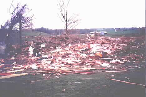
 The damage path was narrow, at times less than 100 yards. Maximum width is uncertain, but possibly up to 500 yards. It appeared that most houses and barns either suffered only minor damage or were completely destroyed. In places where there had been several small houses close together, it was very difficult to tell exactly how many had originally been at that location. After completing our assigned initial survey and starting back to report to the Red Cross, we decided that we had enough time to do a closer inspection of some of the most severe damage.
 The first examination of the house where a man had been killed showed only a very weak foundation, a folded over TV antenna tower, and a pile of debris 50 yards away. It probably had been no more substantial than a mobile home. Further inspection indicated that there had been between three and five houses near there originally. All but one were blown away, sometimes onto the foundation of another house. Large trees were twisted, many were also blown over. A long private lane was covered with the trunks of large pine trees. Interstate 65, near the touchdown point, had been crossed by the twister resulting in a number of accidents that night. Sheets of metal littered the area.
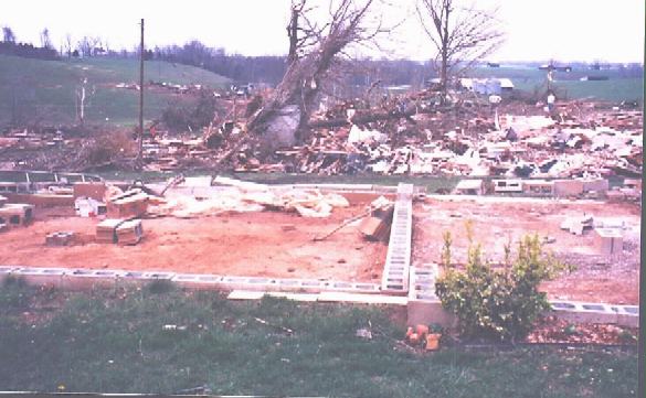
 A number of homes were blown down and swept away. Examination of several of the foundations indicated that they were not substantially built (including the home where the man died and several family members were seriously injured). However, two homes appeared to be much sturdier than the others. One, with nothing left standing, had been bolted to its foundation. On the basis of these two houses we gave this twister a low F4 rating. (The NWS later rated it a strong F3). This one killer tornado did an estimated $6 million in damage, including $1.5 million to the dairy farm in which 80 cows were killed The relatively low damage total results from the fact that its path was over a sparsely populated rural area.
 I had my ever present pocket 35-mm camera plus my wife's waterproof 35, which had been used heavily during the hood cleanup in Louisville. I had been asked to shoot photos for a Disaster Relief Team training class that was to take place in two weeks. To cover what would likely be needed, I had used every roll of color transparency film I had. Thus all I could shoot at the touchdown site was negative film for prints. Since I did not expect to have this tornado touchdown opportunity, the old camcorder remained on its shelf at home - another mistake. As we arrived back at the Red Cross shelter in Magnolia, two Red Cross canteens, including one that had previously come from Silver Springs, Maryland, rolled in. They had been diverted while on their trip home from their work in the flood to set up at one of the tornado touchdown locations.
This Good Friday outbreak spawned at least 7 tornadoes and a much larger number of funnels, causing 28 injuries and two deaths. Kentucky has been averaging 8-10 tornadoes per year since 1952. Already this year (late March 1997) there have been 17 tornadoes! May 1996 sent us the family of four tornadoes that included the F4 multiple vortex tornado that damaged Pioneer Village, Hillview, and Mount Washington, KY. And May 1995 gave us as many tornadoes in that one month as usually occur in three years. I'm sure all this doesn't compare with chasing out in the Great Plains, with its miles and miles of nothing but miles and miles, LP supercells dropping funnels that can be seen ten miles away, a horizon so distant that you can see the curvature of the earth, and Wicked Witches riding bicycles. But it does have its interesting moments.
A summary of this, with 4 photographs, was published in Stormtrack, Volume 21, No. 3, March-April 1998.
Web sites for the huge 1999 May 3 Oklahoma tornado outbreak (courtesy Stormtrack and Tim Marshall):
Government
http://www.nssl.noaa.gov/~nws
http://www.nswnorman.noaa.gov/storms/3may99/index.html
http://fema.gov/mit/bpat/midtorn/index.htm
http://srh/noaa.gov/ftproof/msd/html/assessment/report7.pdf
Commercial
http://www.kfor.com/weather/may_fury.asp
http://www.oklahoman.com/tornado99
http://www.stormproductionsinc.com
Personal
http://www.k5kj.net/990503.htm
http://thedixons.net/weather/050399/050399.html
http://www.wildstar.net/~tornado/3may99/index.html
http://www.spc.noaa.gov/staff/thompson/3may99/index.html
http://www.hamsnet.net/kc5trr/oklahoma_disaster.htm
http://www.weatherpix.com
http://students.ou.edu/B/Keith.B.Brown-1/5399.html
http://weather.ou.edu/~mengel/chase.pix/050399
73, Shelby, W8WN - E-mail,