Wall Cloud
With Significant Rotation
CARES SKYWARN was activated once again on 6 June 2005. That was the third activation this
year. The last activation was on
Memorial Day.
While W5ALL (Alf) maintained radio contact with WX5ABQ
(Keith) in Albuquerque via the MegaLink, KD5ZMD (Steven), KD5ZME (Chris) and
others tracked the severe thunderstorms in our area -- reporting on what they
saw via the Caprock repeater.
Roswell was spared the worst of the storm. Based
mainly on radar data, a tornado warning was issued for north central Chaves
County. Steven was stationed at a safe
spot, southwest of the cell, near the rifle range on US 70 when the warning was
issued. He watched the storm travel northeast, north of the
highway. Steven warned that it looked to him like traffic on US 70 was in
danger. W5ALL passed Steven's message to ABQ NWS. About four
minutes later an 18-wheeler was reported blown over some distance beyond
the Bob Crosby Bridge, northeast of Steven. We don't know if the
accident was due to straight-line wind or a small twister. Later in
the day, that same cell again showed a tornado pattern on radar
(Intelicast) -- south of Portales.
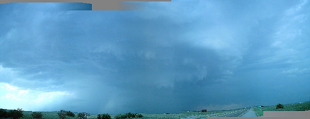
Steven (KD5ZMD) took the above picture of the wall cloud
with rotation from his location on US 70, prior to the wall cloud being
obscured by a wrapping rain column.
Russ (WA3IBE) took the photo at the end of this page from his home in
northeast Roswell.
We also relayed a message to ABQ NWS from a ham at Conchas
lake concerning a cell that dropped golf ball sized hail on Santa
Rosa.
Meanwhile, KD5FTG (Lynn) monitored the Hobbs
area weather net that reports to NWS in Midland, TX. Lynn tells
us Lovington received tennis ball sized hail.
The Same
Storm Viewed From Northeast Roswell
