|
Maldives Geography
The Maldives is situated in the South West of Sri Lanka, on
the equator. The numerous coral reef islands, 1,190 in total,
form an archipelago of 26 natural atolls ( groups of neighbouring
coral islands). These 26 atolls are organised into 19 administrative
atolls with the capital island of Male' established as an entity
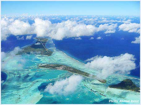
of its own forming the twentieth division. Seen from air, the
atolls and the islands form breathtakingly beautiful patterns
against the blue depths of the Indian Ocean.
The country stretches 823 km north to south and 130 km east
to west. Out of the incredibly large number of islands only
200 islands are inhabited, with 88 islands adapted as exclusive
resort islands. The sea forms over 99 percent of the Maldives.
Only 0.331 percent, 298 km2 (115 square miles), of its 298 km2
(34, 750 square miles) is land.
Together with the Lakshadweep formerly called Laccadive Islands
(formerly part of the Maldives, and now part of India) to the
north and the Chagos Islands to the south, the Maldives form
part of a vast submarine mountain range, on the crest of which
coral reefs have grown. The Maldivian atolls are a classic example
of its kind. The Oxford English Dictionary defines the word
‘atoll’ as "an adoption of the native name "atholhu"
applied to the Maldive Islands , which are typical examples
of this structure". Each of these atolls is enclosed by a coral
reef cut by several deep, natural channels and a lagoon. The
reef structure, peculiar to the Maldives and consisting of a
series of circular reefs in a lime, is known as ‘faru’.
Strong currents, swinging round with the monsoon winds, flow
among the atolls, though a journey between the atolls is often
easy to navigate.
Most of the islands can be walked across in ten minutes; only
a few are longer than two kilometres. The longest, Hithadhoo
in the Southernmost Addu Atoll is eight kilometres (5-6 miles).
Although most other islands are less than a mile long, one feels
no sense of brevity as the merging of beaches, crystal waters,
and crisp blue skies create an infinite vastness - a natural
openness that is rare and a peacefulness that is always welcome.
The usual surface covering of the islands is a six inches deep
layer of dark humus composed of a mixture of sand and organic
matter accumulated from animal and vegetable matter through
the millennia. Sand stone about 2 ft deep is found below, after
which it changes to a layer of sand where fresh water can be
obtained. Some islands where the natural water table is high,
you may find several fresh water lakes The popular tropical
look is finally completed by the green vegetation such as coconut
trees towering above dense shrubs and flowering plants.
Rarely being more than six feet above sea level, the coral
based islands are protected by atoll reefs. However, they are
all susceptible to erosion, especially those lying comparatively
close to the windward reefs. Indeed, in 1812 and again in 1955,
devastating gales destroyed many northern islands. In 1964 the
island in Alifu Atoll "Hagngnaameedhoo" was inundated by high
waves, while the capital, Male', was flooded by a severe storm
in 1987. If, as some scientists predict, the sea level continues
to rise as a result of global warming, then Maldives, with its
ancient and unique culture, may all be swept away within fifty
years. As a precautionary step the government, with aid from
Japan, has undertaken the biggest projects ever in the Maldives
- the building of a breakwater on Male's southern reef. With
the help of artificial measures, such as the new artificial
breakwater and the natural coral reefs the islands have started
to enjoy more protection from natural calamities than they have
ever done before.
As to the origin of these unique atolls, it still remains a
mystery despite years of research. In 1842, after studying other
similar atolls in the Pacific and Atlantic, Charles Darwin suggested
that they were created when volcanic land rose from the sea
and a coral reef grew around its edge. The volcano gradually
sank back into the sea leaving the coral reefs to encircle a
shallow water-filled lagoon. Islands, then, developed when currents
and tides swept coral and other organic debris into sand bars,
which eventually, were colonised by plants and trees. When Darwin,
continued his studies into the Maldive Islands, he had to admit
that there was something special about the Maldive islands.
Nevertheless he added that his theory of coral island formation
was applicable to the Maldives in a general sense, and most
scientists accept his theory. More recently, however, Hans Hass
has suggested that over hundreds of thousands of years a platform
of coral reefs built up on the submerged mountain chain in the
Indian Ocean until they burst through the surface. Porous and
unstable, the coral platform sagged in the middle, leaving only
a ring of the hardest and highest coral - the rims of the atolls
where debris and sand accumulated and vegetation took hold to
form islands. Years and years of the sea moving with shell and
coral particles around the islands, have grounded the debris
into minute grains of sand. It is clear that the tiny specks
of land separated by great stretches of water have long been
a great puzzle.
Just as the early history of Maldives is obscured in mystery,
so is the exact number of islands in the archipelago. The British
Admiralty chart lists some 1,100 islands, while a recent government
count found 1,196. If sand bars and coral outcrops were included
the figure would have been close to 2,000. Obtaining an accurate
is further complicated by the fact that islands come and go.
Some combine, others split in two and occasionally islets emerge
from the coral reefs. A 1955 storm created three new islands
in Shaviyani Atoll, while others have slowly eroded. Around
1960, for instance, the fairly large island of Feydhoo Finolhu
in Male' Atoll almost vanished through a combination of natural
erosion and inhabitants taking away sand. It was later rebuilt.
To compound matters, as yet there is no agreement on what exactly
constitutes an island in the archipelago: what, for instance,
is the status of a large sand spit? Yet all this is part of
the mystique of travelling through The Maldives, where you may
come across an island which has no name, is not shown on any
map and has no human footprint on its shores. Many more show
signs of past settlement, and some desert islands are used regularly
by neighbouring islanders for collecting firewood, coconuts,
and even cultivation. Also, some islands (like the island of
Kuda Bandos, near the capital) are often used as a destination
for weekend / holiday breaks.
|
|