|
The wreck of the R.M.S. Rhone |
|
|
The wreck of the R.M.S. Rhone |
|
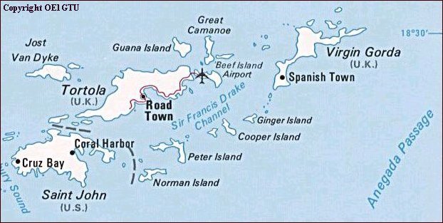
Location: Lee Bay, Salt
Island (British Virgin Islands)
Access: Mooring, Dinghy (NO
ANCHORING-see below)
Rating: Open Water /
Advanced Open Water (Depth, Current)
Max Depth: 60 feet / 80 feet (18,3 meter / 24,4 meter)

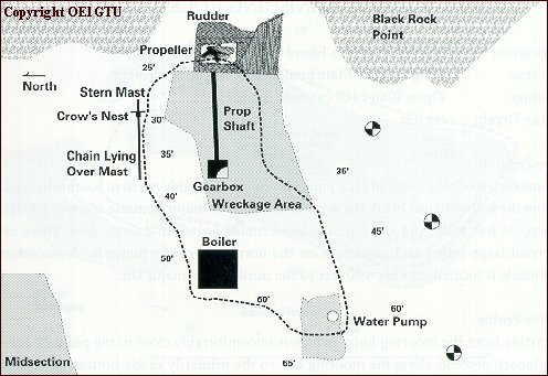
The location of the wreck (9).

The location of the Rhone's Anchor (6).
The wreck of the Royal Mail Steamer Rhone lies in 25 to 80 feet (7,6 to 24,4 meters) of waters just off Black Rock Point on the soutwest tip of Salt Island. The ship's wreckage is stewn over the sea bottom in an area of about 400 feet by 400 feet (122 meters by 122 meters) distributed in two major sections, the bow and the stern.
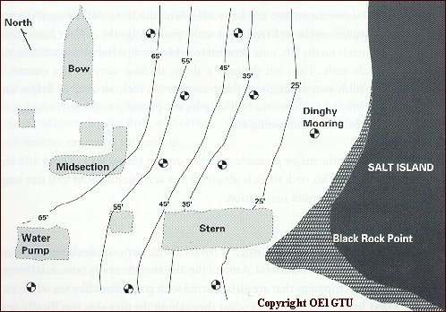
The orientation of the bow and stern with respect to the shoreline and the moorings.
The story of the Rhone and a detailed diagramm of the wreck are contained in the Cruising Guide to the Virgin Islands. For more in depth information (and some great photographs) pick up a copy of George and Luana Marler's book "The Royal Mail Steamer Rhone". Or for a sneak preview of the wreckage, rent the movie "The Deep" where the ship's wreckage stars in the underwater footage.

The shipswreck is a major part of the "R.M.S. Rhone National Park" and is protected by British Virgin Islands law. The taking of any artifacts is not permitted in the National Park. Anchoring, spearfishing, and the taking of coral or shells is also prohibited. To paraphrase, take only pictures and leave only bubbles. This area is visited by hundreds of divers every month, not to mention scores of snorkelers, so every effort should be made to minimize the impact that you as a diver have on the site. Watch your buoyancy, be carefull with your fins, and secure any loose gauges or consoles.
![]() More underwater pictures from the
wreck.
More underwater pictures from the
wreck.
![]()
