Page updated April 9, 2009
Weather
QuickLinks
Florida Weather
Florida's
tornado season is from December
to April with F3 or greater tornadoes. F5
tornadoes have not been recorded in Florida but F4 tornadoes have
been recorded between December thru April. F3 tornadoes have
occurred in May and June at coastal counties and other parts of
Florida once in September and some F3's in October. Small F2 to F0
tornadoes can occur almost any time of the year in Florida.
Tornadoes in Florida can occur anytime of the day and at night
near midnight or predawn hours.
http://www.spc.noaa.gov/faq/tornado/
The Fujita Tornado Scale
Slow
moving severe thunderstorms, usually summertime thunderstorms,
can produce macroburst or microburst wind gust causing major
property damage to a very small area about 2.5 miles, more or
less, in diameter.
http://www.tornadoproject.com/alltorns/fltorn.htm
Hurricane season is from June to November and short-lived tornadoes can be produced by them. Before rapid intensification, some hurricanes have been observed to have intense convection that is sufficient to produce embedded tornadoes, especially within the outer convective rainbands. A hurricane's right-front quadrant relative to its motion is the most likely area for tornado formation. Most hurricane-spawned tornadoes form in outer rainbands some 50 to 200 miles from the cyclone center, but some have occurred in the inner core. The most likely time for hurricane spawned tornadoes is during daylight hours, although they can occur during the night too. There have been no F5-rated tornadoes from hurricanes in the past 50 years of reliable data and only two F4 tornadoes. Tornadoes from hurricanes are often spawned by unusually small storm cells that may not appear dangerous on weather radars, especially if the cells are located more than about 60 miles from the radar. In addition, these small storms often tend to produce little or no lightning and no thunder. Furthermore, the tornadoes are often obscured by rain and the storm cells spawning them may move rapidly, thus leaving little time to take evasive action.
http://www.srh.noaa.gov/jax/skywarn.shtml
http://www.afn.org/~skywarn/emwin/products.html Alachua County
http://www.qsl.net/mcares/ Marion County
http://www.qsl.net/ssrc/races/ Silver Springs
http://www.srh.noaa.gov/mlb/skywarn.html
National Weather Service Melbourne, Florida Amateur Radio Station
WX4MLB
http://www.srh.noaa.gov/mlb/wx4mlb_qsl.html
http://groups.yahoo.com/group/FL_WX_Alert
Weather
Warnings for Florida
NOAA Weather Radio
is a fast source for comprehensive weather and emergency
information.
One of the most important reasons to own a weather radio is the
ability to receive up to the minute information on severe weather.
http://www.srh.noaa.gov/jax/noaaradio.shtml
http://www.srh.noaa.gov/mlb/nwr1.html
If you are under a Warning it is best to leave the weather
radio audio on to get non-alarm Weather Statements that can
contain more important information than just Warnings! Also, the
audio should be on because a storm can knock the weather radio
station off the air. Most stations have a backup channel that
covers the same county so you can switch to that weather radio
channel. Check the local National Weather Service office's web site to find what channels to use in your local area.
_
http://www.weather.gov/ area map for US Better detail and faster updates by
clicking on map area
http://www.srh.noaa.gov/jax/ area map for NWS Jacksonville, FL County
Warning Areas (CWA) updates faster than national map
http://forecast.weather.gov/MapClick.php?zoneid=FLZ040 for Marion County or other Florida County
Zones
http://forecast.weather.gov/showsigwx.php?warnzone=FLZ040&warncounty=FLC083&local_place1=Marion+County
or http://www.srh.noaa.gov/showsigwx.php?warnzone=FLZ040&warncounty=FLC083&local_place1=Marion+County
or http://www.crh.noaa.gov/showsigwx.php?warnzone=FLZ040&warncounty=FLC083&local_place1=Marion+County
http://www.srh.noaa.gov/mlb/ area map for NWS Melbourne, FL County Warning
Areas (CWA) updates
faster than national map
http://www.srh.noaa.gov/tbw/ area map for NWS Tampa, FL County Warning Areas
(CWA) updates
faster than national map
http://www.srh.noaa.gov/data/ area map for Southern Region Auto-Refresh 1 min. Good! Scroll down to
Warning Status for text
Text products indicate the expiration
date and time (UTC
time) about the third line
from top along with the county zone numbers.
It is important to note that a Weather Statement can have
additional important information!
http://www.srh.noaa.gov/wwamap/wwatxtget.php?cwa=jax&wwa=all
http://www.crh.noaa.gov/wwamaps/wwatxtget.php?cwa=JAX&wwa=all
http://140.90.113.200/view/prodsByState.php?state=FL&prodtype=warnings
or http://www.weather.gov/view/prodsByState.php?state=FL&prodtype=warnings
http://140.90.113.200/view/prodsByState.php?state=FL&prodtype=special
or http://www.weather.gov/view/prodsByState.php?state=FL&prodtype=special
http://140.90.113.200/view/prodsByState.php?state=FL&prodtype=watches
or http://www.weather.gov/view/prodsByState.php?state=FL&prodtype=watches
http://140.90.113.200/alerts/fl.html or http://www.weather.gov/alerts/fl.html
http://www.arl.noaa.gov/ready/cmet.html Scroll down to
Weather Text Products to make selections
http://www.arl.noaa.gov/ready/states.html
http://www.arl.noaa.gov/ready-bin/getstate.pl?st=fl&state=Florida scroll down to
Severe Weather
http://www.arl.noaa.gov/ready-bin/state.pl?product=warn&state=fl
EMWIN
Florida backup test links
_
http://www.hamweather.net/cgi-bin/hw3/hw3.cgi?forecast=warnings&place=orlando&state=fl&country=us Good! http://www.wunderground.com/severe.asp Good! Needs
faster reload/refresh times!
http://www.wunderground.com/US/FL/040.html Marion County, FL Auto-Refresh 15
min. Shows ads if no warnings
http://www.wunderground.com/US/FL/045.html Orange County, FL Auto-Refresh 15
min. Shows ads if no warnings
http://www.wunderground.com/US/FL/144.html Lake County (Southern),
FL Auto-Refresh 15 min. Shows ads if no warnings
http://www.wunderground.com/US/FL/
http://www.weatherforyou.com/cgi-bin/hw3/hw3.cgi?state=fl&forecast=pass&pass=warningmap&size=640x480&dpp=1&key=1&nc=forecast,pands,countryAuto-Refresh 5 min.
http://stormdisplay.com/warnings.asp Auto-Refresh
5 min.
http://stormdisplay.com/warnings.asp?cmd=update&state_abr=FL Auto-Refresh
5 min.
http://stormdisplay.com/warnings.asp?cmd=update&state_abr=fl&fips=12083&location=Marion Auto-Refresh
5 min.
http://stormdisplay.com/warnings.asp?cmd=update&state_abr=fl&fips=12095&location=Orange Auto-Refresh
5 min.
http://stormdisplay.com/warnings.asp?cmd=update&state_abr=fl&fips=12069&location=Lake Auto-Refresh 5
min.
http://image.weather.com/images/maps/special/severe_se_720x486.jpg [overwrite se: cn ec nc ne nw sc sw wc us]
http://www.intellicast.com/IcastPage/LoadPage.aspx?loc=kjax&seg=LocalWeather&prodgrp=SevereWeather&product=1kmStormWatch
http://www.intellicast.com/IcastPage/LoadPage.aspx?loc=kmlb&seg=LocalWeather&prodgrp=SevereWeather&product=1kmStormWatch
_
Notice the date
and time! Missing and out-of-date data results in not showing the
latest updates!
http://dweb.met.fsu.edu/index.pl/wxdata/textwx Select
Bulletin type 'warnings' and enter Station '@fl'
http://www.met.tamu.edu/personnel/students/weather/weather_interface.html Select a station
'@fl' and select data category 'other'
http://apollo.lsc.vsc.edu/weather/weather.html Enter station '@fl'
and Select Data 'NWS Warnings'
http://www.weather.brockport.edu/cgi-bin/warning?station=jax&time=Latest Scroll down for
latest
http://www.weather.brockport.edu/cgi-bin/warning?station=jax&time=Today Clear&Reset
for '=Today' at 0000 UTC
http://www.weather.brockport.edu/cgi-bin/warning?station=jax&time=Yesterday Scroll down for
latest
http://www.weather.brockport.edu/cgi-bin/warning?station=mlb&time=Latest Scroll down for
latest
http://www.weather.brockport.edu/cgi-bin/warning?station=mlb&time=Today Clear&Reset
for '=Today' at 0000 UTC
http://www.weather.brockport.edu/cgi-bin/warning?station=mlb&time=Yesterday Scroll down for
latest
http://www.weather.brockport.edu/cgi-bin/warning?station=@fl&time=Latest Scroll down for
latest
http://www.weather.brockport.edu/cgi-bin/warning?station=@fl&time=Today Clear&Reset
for '=Today' at 0000 UTC
http://www.weather.brockport.edu/cgi-bin/warning?station=@fl&time=Yesterday Scroll down for
latest
http://www.atmos.albany.edu/weather/quick.html Enter staion id @fl
and select textual products 'Watch and Warnings'
http://www.atmos.albany.edu/cgi/quick.cgi?station=@fl&warn=yes Watch and
Warnings
http://www.atmos.albany.edu/cgi/quick.cgi?station=@fl
all list
http://twister.sbs.ohio-state.edu/main.php?pageloc=severe
http://wwwagwx.ca.uky.edu/ldmdata/public/FLsevere.html
http://kamala.cod.edu/svr/ Auto-Refresh
2 min. Quick text list of
warnings nationwide.
Text Forecast &
Products from National Weather Service (NWS) Forecast Offices
_
It is recommended you read Forecast Discussions [FXUS62 KJAX -
AFDJAX is for my area; also
read surrounding areas from other Forecast Offices.] because it
gives you details and insight for long term forecasts and
uncertainties in short term forecasts. The for-profit commercial
weather from TV and radio stations uses this government
information but they make it look like they produced it without
giving credit to NOAA NWS forecasters.
http://iwin.nws.noaa.gov/view/states.php or http://www.weather.gov/view/states.php
http://140.90.113.200/view/states.php?state=FL or http://www.weather.gov/view/states.php?state=FL
http://www.srh.noaa.gov/ Interactive map of National Weather Service
Forecast Offices
http://forecast.weather.gov/MapClick.php?CityName=Silver+Springs&state=FL&site=JAX&textField1=29.2243&textField2=-82.0054
http://forecast.weather.gov/MapClick.php?CityName=Ocala&state=FL&site=JAX&textField1=29.1874&textField2=-82.1308
http://forecast.weather.gov/MapClick.php?zoneid=FLZ040 Marion County, FL
http://forecast.weather.gov/MapClick.php?zoneid=FLZ036 Alachua County,
FL
http://forecast.weather.gov/MapClick.php?zoneid=FLZ044 Lake County (Northern),
FL
http://forecast.weather.gov/MapClick.php?zoneid=FLZ045 Orange County, FL
State Forecast (FPUS62 KMFL -
SFPFL)
http://www.weather.gov/view/validProds.php?prod=SFP&node=KMFL
Zone Forecast (FPUS52 KJAX -
ZFPJAX)
_
http://www.srh.noaa.gov/productview.php?pil=ZFPEYW FLORIDA KEYS
or http://www.srh.noaa.gov/data/EYW/ZFPEYW
http://www.srh.noaa.gov/productview.php?pil=ZFPJAX NORTHEAST FLORIDA AND SOUTHEAST GEORGIA
or http://www.srh.noaa.gov/jax/text.php?sid=JAX&pil=ZFP
or http://www.srh.noaa.gov/data/JAX/ZFPJAX
http://www.srh.noaa.gov/productview.php?pil=ZFPMFL SOUTH FLORIDA
or http://www.srh.noaa.gov/data/MFL/ZFPMFL
http://www.srh.noaa.gov/productview.php?pil=ZFPMLB EAST CENTRAL FLORIDA
or http://www.srh.noaa.gov/data/MLB/ZFPMLB
http://www.srh.noaa.gov/productview.php?pil=ZFPTBW WEST CENTRAL AND SOUTHWEST FLORIDA
or http://www.srh.noaa.gov/data/TBW/ZFPTBW
http://www.srh.noaa.gov/productview.php?pil=ZFPTAE TALLAHASSEE FORECAST AREA
or http://www.srh.noaa.gov/data/TAE/ZFPTAE
Alternates listed below
http://weather.noaa.gov/weather/FL_cc_us.html
http://www.arl.noaa.gov/ready/states.html
http://www.arl.noaa.gov/ready-bin/getstate.pl?st=fl&state=Florida
http://twister.sbs.ohio-state.edu/main.php?pageloc=wxbystate
http://twister.sbs.ohio-state.edu/main.php?pageloc=wxbystate&state=florida_panhandle
http://twister.sbs.ohio-state.edu/main.php?pageloc=wxbystate&state=florida_south
http://weather.cod.edu/danatext.html
http://kamala.cod.edu/fl/
http://www.met.tamu.edu/personnel/students/weather/current.html
http://www.met.tamu.edu/personnel/students/weather/htmls/fl.html
http://virga.sfsu.edu/forecasts/
http://www.weather.brockport.edu/cgi-bin/forecast?station=@fl&time=Today Clear&Reset
for '=Today' at 0000 UTC
http://www.weather.brockport.edu/cgi-bin/forecast?station=@fl&time=Yesterday Scroll down for
latest
http://www.weather.brockport.edu/cgi-bin/forecast?station=ocf&time=Latest Scroll down for
latest
http://www.weather.brockport.edu/cgi-bin/forecast?station=mco&time=Latest Scroll down for
latest
http://www.weather.brockport.edu/cgi-bin/discussion?station=@fl&time=Today Clear&Reset
for '=Today' at 0000 UTC
http://www.weather.brockport.edu/cgi-bin/discussion?station=@fl&time=Yesterday Scroll down for
latest
http://www.weather.brockport.edu/cgi-bin/climo?station=@fl&time=Today Scroll down for
latest
http://www.weather.brockport.edu/cgi-bin/climo?station=@fl&time=Yesterday Scroll down for
latest
CENTRAL FLORIDA
Text Products
_
http://iwin.nws.noaa.gov/view/validProds.php or http://www.weather.gov/view/validProds.php
http://www.srh.noaa.gov/product_types_id.html Product Lookup
http://www.srh.noaa.gov/product_types.html
http://140.90.113.200/view/ or www.weather.gov/view/
http://Houston.emwin.org/mdb/recprod.asp?search=jax Product Lookup
http://Houston.emwin.org/mdb/recprod.asp?search=mlb
http://Houston.emwin.org/mdb/recprod.asp?search=tbw
http://www.wxmesg.com/asp/recprod.asp?search=jax Product Lookup
http://www.wxmesg.com/asp/recprod.asp?search=mlb
http://www.wxmesg.com/asp/recprod.asp?search=tbw
http://www.srh.noaa.gov/jax/ Jacksonville, FL area Forecasts & Other Text
Products
http://www.srh.noaa.gov/data/JAX/
http://www.crh.noaa.gov/data/JAX/[insert AFDJAX, PFMJAX, etc.]
http://140.90.113.200/data/JAX/ or http://weather.gov/data/JAX/
http://twister.sbs.ohio-state.edu/text/station/KJAX/?C=N;O=A
http://www.srh.noaa.gov/mlb/ Melbourne, FL area Forecasts & Other Text Products
http://www.srh.noaa.gov/data/MLB/
http://www.crh.noaa.gov/data/MLB/[insert AFDMLB, PFMMLB, etc.]
http://140.90.113.200/data/MLB/ or http://weather.gov/data/MLB/
http://twister.sbs.ohio-state.edu/text/station/KMLB/?C=N;O=A
http://www.srh.noaa.gov/tbw/ Tampa, FL area Forecasts & Other Text Products
http://www.srh.noaa.gov/data/TBW/
http://www.crh.noaa.gov/data/TBW/[insert AFDTBW, PFMTBW, etc.]
http://140.90.113.200/data/TBW/ or http://weather.gov/data/TBW/
http://twister.sbs.ohio-state.edu/text/station/KTBW/?C=N;O=A
Tabular Forecast
_
http://www.srh.noaa.gov/forecast/gridpoint.php?site=jax [select Digital/Tabular in the drop-down box then click
on map or click map then Tabular Forecast at bottom right of page]
http://forecast.weather.gov/MapClick.php?CityName=Silver+Springs&state=FL&site=JAX&textField1=29.2243&textField2=-82.0054&FcstType=digital
http://forecast.weather.gov/MapClick.php?CityName=Ocala&state=FL&site=JAX&textField1=29.1874&textField2=-82.1308&FcstType=digital
http://www.srh.noaa.gov/forecast/gridpoint.php?site=tbw
http://www.srh.noaa.gov/forecast/gridpoint.php?site=mlb
Point Forecast
Matrices (FOUS52 KJAX - PFMJAX)
_
http://www.srh.noaa.gov/productview.php?pil=PFMEYW FLORIDA KEYS
or http://www.srh.noaa.gov/data/EYW/PFMEYW
http://www.srh.noaa.gov/productview.php?pil=PFMJAX NORTHEAST FLORIDA AND SOUTHEAST GEORGIA
or http://www.srh.noaa.gov/jax/text.php?sid=JAX&pil=PFM
or http://www.srh.noaa.gov/data/JAX/PFMJAX
http://www.srh.noaa.gov/productview.php?pil=PFMMFL SOUTH FLORIDA
or http://www.srh.noaa.gov/data/MFL/PFMMFL
http://www.srh.noaa.gov/productview.php?pil=PFMMLB EAST CENTRAL FLORIDA
or http://www.srh.noaa.gov/data/MLB/PFMMLB
http://www.srh.noaa.gov/productview.php?pil=PFMTBW WEST CENTRAL AND SOUTHWEST FLORIDA
or http://www.srh.noaa.gov/data/TBW/PFMTBW
http://www.srh.noaa.gov/productview.php?pil=PFMTAE TALLAHASSEE FORECAST AREA
or http://www.srh.noaa.gov/data/TAE/PFMTAE
Alternates
http://iwin.nws.noaa.gov/view/validProds.php?prod=PFM&node=KJAX
http://www.weather.gov/view/validProds.php?prod=PFM&node=KJAX
http://weather.noaa.gov/pub/data/raw/fp/?C=M;O=D
http://weather.noaa.gov/pub/data/raw/fo/fous52.kjax.pfm.jax.txt
http://www.crh.noaa.gov/product.php?site=JAX&product=PFM&issuedby=JAX
http://mobile.srh.weather.gov/pil.php?pil=JAXPFMJAX
http://twister.sbs.ohio-state.edu/text/station/KJAX/?C=N;O=A
http://twister.sbs.ohio-state.edu/text/station/KJAX/FOUS52.KJAX
http://kamala.cod.edu/fl/latest.fous52.KJAX.html
http://wwwagwx.ca.uky.edu/ldmdata/models/ngm/FOUS52.KJAX
Tabular Area Forecast (FPUS62
KJAX - SFTJAX)
_
http://www.srh.noaa.gov/productview.php?pil=SFTEYW FLORIDA KEYS
or http://www.srh.noaa.gov/data/EYW/SFTEYW
http://www.srh.noaa.gov/productview.php?pil=SFTJAX NORTHEAST FLORIDA AND SOUTHEAST GEORGIA
or http://www.srh.noaa.gov/jax/text.php?sid=JAX&pil=SFT
or http://www.srh.noaa.gov/data/JAX/SFTJAX
http://www.srh.noaa.gov/productview.php?pil=SFTMFL SOUTH FLORIDA
or http://www.srh.noaa.gov/data/MFL/SFTMFL
http://www.srh.noaa.gov/productview.php?pil=SFTMLB EAST CENTRAL FLORIDA
or http://www.srh.noaa.gov/data/MLB/SFTMLB
http://www.srh.noaa.gov/productview.php?pil=SFTTBW WEST CENTRAL AND SOUTHWEST FLORIDA
or http://www.srh.noaa.gov/data/TBW/SFTTBW
http://www.srh.noaa.gov/productview.php?pil=SFTTAE TALLAHASSEE FORECAST AREA
or http://www.srh.noaa.gov/data/TAE/SFTTAE
Alternates
http://iwin.nws.noaa.gov/view/validProds.php?prod=SFT&node=KJAX
http://www.weather.gov/view/validProds.php?prod=SFT&node=KJAX
http://weather.noaa.gov/pub/data/raw/fp/?C=M;O=D
http://weather.noaa.gov/pub/data/raw/fp/fpus62.kjax.sft.jax.txt
http://www.crh.noaa.gov/product.php?site=JAX&product=SFT&issuedby=JAX
http://mobile.srh.weather.gov/pil.php?pil=JAXSFTJAX
http://twister.sbs.ohio-state.edu/text/station/KJAX/?C=N;O=A
http://twister.sbs.ohio-state.edu/text/station/KJAX/FPUS62.KJAX
http://kamala.cod.edu/fl/latest.fpus62.KJAX.html
http://houston.emwin.org/rxfiles/SFTJAXFL.TXT
Model Output Statistics (MOS) Forecast
Guidance (US)
http://www.nws.noaa.gov/mdl/gfslamp/gfslamp.shtml GFS LAMP
http://www.nws.noaa.gov/mdl/gfslamp/bullform.html GFS LAMP
http://www.nws.noaa.gov/cgi-bin/lamp/getlav.pl?sta=KOCF
http://www.nws.noaa.gov/cgi-bin/lamp/getlav.pl?sta=KGNV
http://www.nws.noaa.gov/cgi-bin/lamp/getlav.pl?sta=KVVG
http://www.nws.noaa.gov/mdl/synop/ Model Output Statistics (MOS)
http://www.nws.noaa.gov/mdl/synop/products.shtml
http://www.nws.noaa.gov/mdl/synop/products/bullform.all.htm GFS NAM GFSX NGM
http://www.nws.noaa.gov/cgi-bin/mos/getall.pl?sta=KOCF
http://www.nws.noaa.gov/cgi-bin/mos/getall.pl?sta=KGNV
http://www.nws.noaa.gov/cgi-bin/mos/getall.pl?sta=KVVG
http://www.nws.noaa.gov/mdl/synop/avnmosmap.htm
http://www.nws.noaa.gov/mdl/synop/products/bullform.mav.htm GFS
http://www.nws.noaa.gov/cgi-bin/mos/getmav.pl?sta=KOCF
http://www.nws.noaa.gov/mdl/synop/etamosmap.htm
http://www.nws.noaa.gov/mdl/synop/products/bullform.met.htm NAM
http://www.nws.noaa.gov/cgi-bin/mos/getmet.pl?sta=KOCF
http://www.nws.noaa.gov/mdl/synop/mrfmosmap.htm
http://www.nws.noaa.gov/mdl/synop/products/bullform.mex.htm GFSX
http://www.nws.noaa.gov/cgi-bin/mos/getmex.pl?sta=KOCF
http://www.nws.noaa.gov/mdl/synop/ngmmosmap.htm
http://www.nws.noaa.gov/mdl/forecast/ngm/bullform.htm NGM
http://www.nws.noaa.gov/cgi-bin/mos/getfwc.pl?sta=GNV
http://www.nws.noaa.gov/cgi-bin/mos/getfwc.pl?sta=MCO
http://www.nws.noaa.gov/mdl/synop/products/bullform.ens.htm GFS MRF ens
http://www.nws.noaa.gov/cgi-bin/mos/getens.pl?sta=KOCF
http://www.nws.noaa.gov/cgi-bin/mos/getens.pl?sta=KGNV
http://www.nws.noaa.gov/cgi-bin/mos/getens.pl?sta=KVVG
http://www.nws.noaa.gov/mdl/synop/products/bullform.gfsmmg.htm GFS Marine
http://www.nws.noaa.gov/mdl/synop/stadrg.htm Current GFS and Eta MOS Stations and WMO Headers
http://kamala.cod.edu/offs/KWNO/?M=D
http://weather.noaa.gov/pub/data/raw/fo/fous10.kwno.mcg.usa.txt
http://twister.sbs.ohio-state.edu/text/station/KWNO/FOUS10.KWNO
http://wwwagwx.ca.uky.edu/ldmdata/models/ngm/FOUS10.KWNO
http://weather.noaa.gov/pub/data/raw/fe/feus10.kwno.mcx.usa.txt
http://twister.sbs.ohio-state.edu/text/station/KWNO/FEUS10.KWNO
http://wwwagwx.ca.uky.edu/ldmdata/outlook/FEUS10.KWNO
OCAF1 29.2000 -82.0833 N29.0803 W082.0778
http://www.srh.weather.gov/data/WNO/MCXUSA FEUS10 KWNO - MCXUSA GFSX-BASED MOS COOP (OCAF1)
http://www.srh.weather.gov/data/WNO/MCGUSA FOUS10 KWNO - MCGUSA GFS-BASED MOS COOP (OCAF1)
http://www.srh.weather.gov/data/WNO/LAVUSA FOUS11 KWNO - LAVUSA GFS LAMP (KOCF)
http://www.srh.weather.gov/data/WNO/MAVSE1 FOUS22 KWNO - MAVSE1 GFS MOS GUIDANCE (KOCF)
http://www.srh.weather.gov/data/WNO/METSE1 FOUS45 KWNO - METSE1 ETA MOS GUIDANCE (KOCF)
http://www.srh.weather.gov/data/WNO/MEXSE1 FEUS22 KWNO - MEXSE1 GFSX MOS GUIDANCE (KOCF)
http://www.srh.weather.gov/data/WNO/MMESE1 FQUS42 KWNO - MMESE1 ETA MOS GUIDANCE (marine)
http://www.srh.weather.gov/data/WNO/MMGSE1 FQUS22 KWNO - MMGSE1 GFS MOS GUIDANCE (marine)
Alternates
http://www.srh.noaa.gov/data/Guidance/GFS/
http://www.srh.noaa.gov/data/Guidance/GFS/SE1_KOCF.1.txt
http://www.srh.noaa.gov/data/Guidance/GFS/SE1_KGNV.1.txt
http://www.srh.noaa.gov/data/Guidance/GFS/SE1_KVVG.1.txt
http://www.srh.noaa.gov/data/Guidance/MET/ ETA or NAM
http://www.srh.noaa.gov/data/Guidance/MET/SE1_KOCF.1.txt
http://www.srh.noaa.gov/data/Guidance/MET/SE1_KGNV.1.txt
http://www.srh.noaa.gov/data/Guidance/MET/SE1_KVVG.1.txt
http://www.srh.noaa.gov/data/Guidance/GFX/
http://www.srh.noaa.gov/data/Guidance/GFX/SE1_KOCF.1.txt
http://www.srh.noaa.gov/data/Guidance/GFX/SE1_KGNV.1.txt
http://www.srh.noaa.gov/data/Guidance/GFX/SE1_KVVG.1.txt
http://www.srh.noaa.gov/data/Guidance/FWC/ NGM
http://www.srh.noaa.gov/data/Guidance/FWC/GNV.1.txt
http://www.srh.noaa.gov/data/Guidance/FWC/MCO.1.txt
http://www.crh.noaa.gov/product.php?site=JAX&product=MAV&issuedby=SE1
http://www.crh.noaa.gov/product.php?site=JAX&product=MET&issuedby=SE1
http://www.crh.noaa.gov/product.php?site=JAX&product=MEX&issuedby=SE1
http://twister.sbs.ohio-state.edu/text/avnmos/?C=N;O=A
http://twister.sbs.ohio-state.edu/text/mrfmos/?C=N;O=A
http://twister.sbs.ohio-state.edu/text/ngmmos/?C=N;O=A
Area
Forecast Discussion (FXUS62 KJAX - AFDJAX)
_
http://www.srh.noaa.gov/productview.php?pil=AFDEYW FLORIDA KEYS
or http://www.srh.noaa.gov/data/EYW/AFDEYW
http://www.srh.noaa.gov/productview.php?pil=AFDJAX NORTHEAST FLORIDA AND SOUTHEAST GEORGIA
or http://www.srh.noaa.gov/jax/text.php?sid=JAX&pil=AFD
or http://www.srh.noaa.gov/data/JAX/AFDJAX
http://www.srh.noaa.gov/productview.php?pil=AFDMFL SOUTH FLORIDA
or http://www.srh.noaa.gov/data/MFL/AFDMFL
http://www.srh.noaa.gov/productview.php?pil=AFDMLB EAST CENTRAL FLORIDA
or http://www.srh.noaa.gov/data/MLB/AFDMLB
http://www.srh.noaa.gov/productview.php?pil=AFDTBW WEST CENTRAL AND SOUTHWEST FLORIDA
or http://www.srh.noaa.gov/data/TBW/AFDTBW
http://www.srh.noaa.gov/productview.php?pil=AFDTAE TALLAHASSEE FORECAST AREA
or http://www.srh.noaa.gov/data/TAE/AFDTAE
Alternates
http://iwin.nws.noaa.gov/view/validProds.php?prod=AFD&node=KJAX
http://140.90.113.200/pub/data/JAX/AFDJAX
http://www.weather.gov/view/validProds.php?prod=AFD&node=KJAX
http://www.weather.gov/data/JAX/AFDJAX
http://weather.noaa.gov/pub/data/raw/fx/?C=M;O=D
http://weather.noaa.gov/pub/data/raw/fx/fxus62.kjax.afd.jax.txt
http://www.crh.noaa.gov/product.php?site=JAX&product=AFD&issuedby=JAX
http://www.crh.noaa.gov/data/JAX/AFDJAX
http://www.srh.noaa.gov/port/pil.php?pil=JAXAFDJAX
http://mobile.srh.weather.gov/pil.php?pil=JAXAFDJAX
http://twister.sbs.ohio-state.edu/text/station/KJAX/?C=N;O=A
http://twister.sbs.ohio-state.edu/text/station/KJAX/FXUS62.KJAX
http://kamala.cod.edu/fl/latest.fxus62.KJAX.html
http://houston.emwin.org/rxfiles/AFDJAXFL.TXT
http://mobile.wunderground.com/auto/mobile/DisplayDisc.asp?DiscussionCode=JAX&StateCode=FL
Climate Report [use to verify previous
forecasts]
(ASUS62 KJAX - RTPJAX includes Ocala, FL) (CXUS52 KJAX - CF6GNV
Gainseville, FL) (CDUS42 KJAX - CLIGNV Gainesville, FL)
http://140.90.113.200/view/prodsByState.php?state=FL&prodtype=climate
or http://www.weather.gov/view/prodsByState.php?state=FL&prodtype=climate
Alternates
http://www.srh.noaa.gov/jax/text.php?sid=JAX&pil=RTP
http://www.srh.noaa.gov/jax/text.php?sid=GNV&pil=CF6
http://www.srh.noaa.gov/jax/text.php?sid=GNV&pil=CLI
http://www.srh.noaa.gov/productview.php?pil=RTPJAX
http://www.srh.noaa.gov/productview.php?pil=CF6GNV
http://www.srh.noaa.gov/productview.php?pil=CLIGNV
http://www.crh.noaa.gov/product.php?site=JAX&product=RTP&issuedby=JAX
http://www.crh.noaa.gov/product.php?site=JAX&product=CF6&issuedby=GNV
http://www.crh.noaa.gov/product.php?site=JAX&product=CLI&issuedby=GNV
http://iwin.nws.noaa.gov/view/validProds.php?prod=RTP&node=KJAX
or http://www.weather.gov/view/validProds.php?prod=RTP&node=KJAX
http://iwin.nws.noaa.gov/view/validProds.php?prod=CF6&node=KJAX
or http://www.weather.gov/view/validProds.php?prod=CF6&node=KJAX
http://iwin.nws.noaa.gov/view/validProds.php?prod=CLI&node=KJAX
or http://www.weather.gov/view/validProds.php?prod=CLI&node=KJAX
http://houston.emwin.org/rxfiles/RTPJAXFL.TXT
http://twister.sbs.ohio-state.edu/text/station/KJAX/ASUS62.KJAX
http://kamala.cod.edu/fl/latest.asus62.KJAX.html
http://wwwagwx.ca.uky.edu/ldmdata/obs/ASUS62.KJAX
http://www.atmos.albany.edu/gopher-local/abus22/KJAX-62
Coded Cities Forecast
(FPUS42 KJAX - CCFJAX)
_
http://www.srh.noaa.gov/productview.php?pil=CCFEYW FLORIDA KEYS
or http://www.srh.noaa.gov/data/EYW/CCFEYW
http://www.srh.noaa.gov/productview.php?pil=CCFJAX NORTHEAST FLORIDA AND SOUTHEAST GEORGIA
or http://www.srh.noaa.gov/jax/text.php?sid=JAX&pil=CCF
or http://www.srh.noaa.gov/data/JAX/CCFJAX
http://www.srh.noaa.gov/productview.php?pil=CCFMFL SOUTH FLORIDA
or http://www.srh.noaa.gov/data/MFL/CCFMFL
http://www.srh.noaa.gov/productview.php?pil=CCFMLB EAST CENTRAL FLORIDA
or http://www.srh.noaa.gov/data/MLB/CCFMLB
http://www.srh.noaa.gov/productview.php?pil=CCFTBW WEST CENTRAL AND SOUTHWEST FLORIDA
or http://www.srh.noaa.gov/data/TBW/CCFTBW
http://www.srh.noaa.gov/productview.php?pil=CCFTAE TALLAHASSEE FORECAST AREA
or http://www.srh.noaa.gov/data/TAE/CCFTAE
Alternates
http://iwin.nws.noaa.gov/view/validProds.php?prod=CCF&node=KJAX
http://www.weather.gov/view/validProds.php?prod=CCF&node=KJAX
http://weather.noaa.gov/pub/data/raw/fp/?C=M;O=D
http://weather.noaa.gov/pub/data/raw/fp/fpus42.kjax.ccf.jax.txt
http://www.crh.noaa.gov/product.php?site=JAX&product=CCF&issuedby=JAX
http://mobile.srh.weather.gov/pil.php?pil=JAXCCFJAX
http://twister.sbs.ohio-state.edu/text/station/KJAX/?C=N;O=A
http://twister.sbs.ohio-state.edu/text/station/KJAX/FPUS42.KJAX
CCCC - Four-letter NWS office identifier
http://www.nws.noaa.gov/datamgmt/x_ref/xr08_CCCC_ID_List.html
The Coded Cities Forecast is a coded forecast that is routinely
issued twice daily around 200 to 400 a.m. and
200 to 400 p.m. along with the Zone Forecast. It provides a
detailed overview of the forecast for 14 periods,
or the next seven days. The Coded Cities Forecast will have a
different sequence depending upon the
transmission time. The forecast takes the following format.
4:00 a.m.
LLL D1D2 max/min max/min max FFP1P2P3
D3D4D5D6D7 min/max min/max min/max min/max min P4P5P6P7P8P9P10P11P12P13P14
4:00 p.m.
LLL D1D2 min/max min/max min FFP1P2P3
D3D4D5D6D7 max/min max/min max/min max/min max P4P5P6P7P8P9P10P11P12P13P14
A description of each part of the coded cities forecast follows:
LLL - Three-letter station identifier:
http://www.nws.noaa.gov/tg/siteloc.shtml enter K and then the Three-letter station identifier
D1, D2, D3, D4, D5, D6, D7 - One-word forecast which represents
the predominate weather expected
during the daylight hours for that day.
The following list gives the corresponding letters and weather
elements.
A Fair
B Partly Cloudy
C Cloudy
D Dust
E Mostly Cloudy
F Foggy
G Very Hot or Hot/Humid
H Haze
I Very Cold/Wind Chill
J Snow Showers
K Smoke
L Drizzle
M Snow Showers
N Windy
O Rain or snow Mixed
P Blizzard
Q Blowing Snow
R Rain
S Snow
T Thunderstorms
U Sunny
V Clear
W Rain Showers
X Sleet
Y Freezing Rain
Z Freezing Drizzle
max/min or min/max - Temperatures (°F) are encoded with three
digits. For example, 52°F is encoded 052,
112°F is encoded 112, 7°F is encoded 007. Temperatures below
zero are preceded by the digit 9. For
example, -15°F is encoded 915.
FF - The forecaster's identification number with digits 01
through 99.
P1P2P3 - Probability of Precipitation (POP) values for
consecutive 12-hour periods through 7 days. If the probability
of precipitation is 50% or greater, the corresponding one-word
forecast for that day will normally be for the precipitation
event.
The value is coded as follows:
Percent Code
near zero 0
5 -
10 1
20 2
30 3
...etc...
90 9
near 100 +
Graphical
Forecast
_
http://www.weather.gov/forecasts/graphical/sectors/ click-on map for local Graphical Forecasts
or Graphic_Forecast/ Graphical Forecasts no javascript
http://www.hpc.ncep.noaa.gov/ Hydrometeorological Prediction Center
http://www.spc.noaa.gov/ Storm Prediction Center
http://www.cpc.ncep.noaa.gov/products/predictions/threats/ Climate Prediction Center
http://www.srh.noaa.gov/jax/ local National Weather Service in Jacksonville, FL - click on Forecast Graphics
http://www.srh.noaa.gov/jax/severe.shtml Severe Weather
http://www.srh.noaa.gov/jax/ghls/hls_main.shtml Experimental
Graphical Hurricane Local Statement
http://www.srh.noaa.gov/graphical/sectors/jax.php Public Graphical Forecasts [javascript]
http://www.srh.noaa.gov/mlb/ local National Weather Service in Melbourne, FL - click on Graphics
http://www.srh.noaa.gov/mlb/ghwo/ghwomain.shtml Graphical
Hazardous Weather Outlook
http://www.srh.noaa.gov/mlb/ghls/hls_main.html Experimental
Graphical Hurricane Local Statement
http://www.srh.noaa.gov/mlb/ARPS.html 9-hr Mesoscale
Forecast (WRF) [javascript]
http://www.srh.noaa.gov/mlb/wrf/GIF/
http://www.srh.noaa.gov/graphical/sectors/mlb.php Public Graphical Forecasts [javascript]
Florida precipitation
forecast (40 km has better scaling maps):
Add WMO ID = mco | Change Parameter Field 1 = Accumulated
Precipitation (SFC) | Change Contour type Field 1 = Color Filled
| Choose a date/time | Click on Request plot
http://www.arl.noaa.gov/ready/cmet.html
http://www.arl.noaa.gov/ready-bin/main.pl?WMO=ocf&Lat=&Lon=
http://www.arl.noaa.gov/ready-bin/main.pl?WMO=mco&Lat=&Lon=
http://ruc.fsl.noaa.gov/ select RUC then select South East
http://aviationweather.gov/products/nws/tafs/graphics/ Aviation Terminal
Area Graphics
http://merv.metr.ou.edu/weather/ HIRES
http://cimss.ssec.wisc.edu/model/daily/region_EW.html
http://www.sfwmd.gov/org/omd/ops/weather/3_models.html
http://vortex.plymouth.edu/focalc.html
http://vortex.plymouth.edu/fouswx.html
_
http://image.weather.com/web/forecast/us_se_9regwxhi1_large_usen.jpg [overwrite se: cn ec nc ne nw sc sw wc]
http://image.weather.com/web/forecast/us_se_9regwxlo1_large_usen.jpg
http://image.weather.com/web/forecast/us_se_9regwxhi2_large_usen.jpg
http://image.weather.com/web/forecast/us_se_9regwxlo2_large_usen.jpg
http://image.weather.com/web/forecast/us_se_9regwxhi3_large_usen.jpg
http://image.weather.com/web/forecast/us_se_9regwxlo3_large_usen.jpg
http://image.weather.com/web/forecast/us_se_9regwxhi4_large_usen.jpg
http://image.weather.com/web/forecast/us_se_9regwxlo4_large_usen.jpg
http://image.weather.com/web/forecast/us_se_9regwxhi5_large_usen.jpg
http://image.weather.com/web/forecast/us_se_9regwxlo5_large_usen.jpg
http://image.weather.com/web/forecast/us_se_9regwxhi6_large_usen.jpg
http://image.weather.com/web/forecast/us_se_9regwxlo6_large_usen.jpg
http://image.weather.com/web/forecast/us_se_9regwxhi7_large_usen.jpg
http://image.weather.com/web/forecast/us_se_9regwxlo7_large_usen.jpg
http://image.weather.com/web/forecast/us_se_9regwxhi8_large_usen.jpg
http://image.weather.com/web/forecast/us_se_9regwxlo8_large_usen.jpg
http://image.weather.com/web/forecast/us_se_9regwxhi9_large_usen.jpg
http://image.weather.com/web/forecast/us_se_9regwxlo9_large_usen.jpg
http://image.weather.com/web/forecast/us_se_9regwxhi10_large_usen.jpg
http://image.weather.com/web/forecast/us_se_9regwxlo10_large_usen.jpg
http://image.weather.com/images/maps/travel/travel_southeast_720x486.jpg [overwrite southeast: midwest northeast west]
http://image.weather.com/images/maps/travel/se_trvlthun_720x486.jpg [overwrite se: cen ecen ncen ne nw scen sw wcen]
http://image.weather.com/images/maps/forecast/se_precfcst_720x486.jpg [overwrite se: cen ecen ncen ne nw scen sw wcen]
http://image.weather.com/images/maps/boat-n-beach/fl_fcst_720x486.jpg
http://image.weather.com/images/maps/boat-n-beach/fl_fcst_uv_720x486.jpg
http://image.weather.com/images/maps/boat-n-beach/fl_water_720x486.jpg
http://image.weather.com/images/maps/boat-n-beach/coastal_wind_southeast_720x486.jpg [overwrite southeast: northeast west]
http://image.weather.com/images/maps/boat-n-beach/surf_southeast_720x486.jpg [overwrite southeast: east northeast west]
http://image.weather.com/images/maps/boat-n-beach/gale_southeast_720x486.jpg [overwrite southeast: east northeast west]
http://image.weather.com/images/maps/boat-n-beach/watertemp_southeast_720x486.jpg [overwrite southeast: northeast west]
http://image.weather.com/images/maps/boat-n-beach/svr_flood_southeast_720x486.jpg [overwrite southeast: east northeast west]
http://image.weather.com/images/maps/winter/ski_se_720x486.jpg [overwrite se: cen ecen ncen ne nw scen sw wcen]
http://www.weather.com/weather/local/34470 Orlando
http://www.weather.com/weather/local/32801 Orlando
http://zip4.usps.com/zip4/citytown.jsp Find a ZIP Code in a city
http://www.intellicast.com/IcastPage/LoadPage.aspx?loc=kocf&seg=LocalWeather&prodgrp=Forecasts&product=Forecast (cookie)
http://www.intellicast.com/IcastPage/LoadPage.aspx?loc=kmco&seg=LocalWeather&prodgrp=Forecasts&product=Forecast (cookie)
Meteogram
Forecast [US, Ocala (OCF), or Gainesville (GNV)]
_
http://www.srh.weather.gov/ click on map
http://www.srh.noaa.gov/jax/ click on map then select Hourly Weather Graph
http://forecast.weather.gov/MapClick.php?CityName=Silver+Springs&state=FL&site=JAX&textField1=29.2243&textField2=-82.0054&FcstType=graphical
http://forecast.weather.gov/MapClick.php?CityName=Ocala&state=FL&site=JAX&textField1=29.1874&textField2=-82.1308&FcstType=graphical
http://www.srh.noaa.gov/mlb/ click on map then select Hourly Weather Graph
http://www.arl.noaa.gov/ready/cmet.html
http://www.arl.noaa.gov/ready-bin/main.pl?WMO=ocf&Lat=&Lon=
http://www.arl.noaa.gov/ready-bin/main.pl?WMO=gnv&Lat=&Lon=
http://wxmaps.org/pix/meteograms.html
http://www.emc.ncep.noaa.gov/mmb/nammeteograms/
http://www.emc.ncep.noaa.gov/mmb/srefmeteograms/sref.html
http://www.emc.ncep.noaa.gov/mmb/rucmeteograms/
http://wwwt.emc.ncep.noaa.gov/gmb/pan/
http://www.nlmoc.navy.mil/meteograms/cgi-bin/meteo1.cgi COAMPS NOGAPS GFS
http://vortex.plymouth.edu/make.html
http://cimss.ssec.wisc.edu/model/daily/site.html
http://coolwx.com/cgi-bin/getbufr.php?region=FL&stn=KGNV&model=nam&time=current&field=prec
Aviation
Regional Forecast [US, Gainesville,FL (KGNV), Leesburg, FL (KLEE),
Sanford, FL (KSFB), or Orlando,FL (KMCO)]
Also check Aviation
Weather
_
http://aviationweather.gov/adds/tafs/ Terminal Area
Forecast KGNV KLEE KSFB KMCO
http://weather.noaa.gov/weather/taf.shtml (alternative)
http://weather.noaa.gov/cgi-bin/mgettaf.pl?cccc=kgnv Gainesville
http://weather.noaa.gov/cgi-bin/mgettaf.pl?cccc=klee Leesburg
http://weather.noaa.gov/cgi-bin/mgettaf.pl?cccc=ksfb Sanford
http://weather.noaa.gov/cgi-bin/mgettaf.pl?cccc=kmco Orlando
http://www.srh.noaa.gov/data/JAX/TAFGNV (alternative)
http://www.srh.noaa.gov/data/MLB/TAFLEE (alternative)
http://www.srh.noaa.gov/data/MLB/TAFSFB (alternative)
http://www.srh.noaa.gov/data/MLB/TAFMCO (alternative)
http://aviationweather.gov/products/fa/ Aviation Area
Forecast
http://aviationweather.gov/products/fa/dynamic/miami_fa.shtml SouthEast
https://avweb.weather.navy.mil/cgi-bin/metartafsearch/metar_taf_from_search.cgi?text=KGNV
https://avweb.weather.navy.mil/cgi-bin/metartafsearch/metar_taf_from_search.cgi?text=KLEE
https://avweb.weather.navy.mil/cgi-bin/metartafsearch/metar_taf_from_search.cgi?text=KSFB
https://avweb.weather.navy.mil/cgi-bin/metartafsearch/metar_taf_from_search.cgi?text=KMCO
http://squall.sfsu.edu/forecasts/aviation/ (alternative)
http://squall.sfsu.edu/forecasts/aviation/MIA.aviation SouthEast
http://Houston.emwin.org/rxfiles/FAAMIAUS.TXT (alternative) SouthEast
http://Houston.emwin.org/rxfiles/AWWMLBFL.TXT Aviation Weather Warning
http://aviationweather.gov/products/nws/fdwinds/dynamic/miami_fd1.shtml 6 hour Winds
Aloft Forecasts
http://aviationweather.gov/products/nws/fdwinds/dynamic/miami_fd2.shtml 12 hour Winds
Aloft Forecasts
http://aviationweather.gov/products/nws/fdwinds/dynamic/miami_fd3.shtml 24 hour Winds
Aloft Forecasts
http://www.nws.noaa.gov/oso/oso1/oso12/images/qkcard.gif Quick guide decode
METAR and TAF
http://www.nws.noaa.gov/oso/oso1/oso12/d31/d-31prt1.htm
http://www.nws.noaa.gov/oso/oso1/oso12/d31/d-31prt3.htm TAF Coding
http://www.nws.noaa.gov/oso/oso1/oso12/d31/D31app3.htm ACRONYMS
_
http://aviationweather.gov/adds/data/airmets/airmets_CB.gif
http://aviationweather.gov/adds/cgi-bin/adds_airmets?CONVECT=on
http://aviationweather.gov/products/ccfp/ Collaborative
Convective Forecast Product - click on area to zoom
http://aviationweather.gov/products/cwsu/dynamic/kzjx.shtml Jacksonville
Center special weather advisories
http://aviationweather.gov/products/cwsu/dynamic/kzma.shtml Miami Center
special weather advisories
Current
Conditions or enter your location [Hourly unless otherwise
noted]
_
The
current conditions are derived from airport observations (METARs)
near the top of the hour. Special airport observations (SPECs)
are issued individually only for significant changes between the
hour. Airport observations provide excellent quality or accuracy
control of the data, a reason they are used by TV and radio
stations. Non-airport Cooperative Observer Program (COOP such as
school, agri., etc.) automated stations are updated more often
than hourly but can lack in quality or accuracy of data. Some
links to current conditions may not show the most recent
observation so always check the time stamp in the product.
Other sources of current weather are listed at the following links.
http://madis.noaa.gov/network_info.html Meteorological Assimilation Data Ingest System (MADIS) Surface Network Information
http://msas.noaa.gov/qcms.html Quality Control and Monitoring System
http://www.ncdc.noaa.gov/crn/ U.S. Climate Reference Network (USCRN)
http://forecast.weather.gov/MapClick.php?zoneid=FLZ040 Marion County, FL or other County Zones in Florida
http://forecast.weather.gov/MapClick.php?CityName=Silver+Springs&state=FL&site=JAX&textField1=29.2243&textField2=-82.0054
http://forecast.weather.gov/MapClick.php?CityName=Ocala&state=FL&site=JAX&textField1=29.1874&textField2=-82.1308
http://forecast.weather.gov/obslocal.php?warnzone=FLZ040&local_place=Marion+County&zoneid=EST&offset=18000 or
http://forecast.weather.gov/obslocal.php?warnzone=FLZ040&local_place=Marion+County&zoneid=EDT&offset=14400
http://www.weather.gov/data/obhistory/KOCF.html Ocala, FL
http://www.weather.gov/data/obhistory/KGNV.html Gainesville, FL
http://www.weather.gov/data/obhistory/KVVG.html The Villages, FL
http://www.weather.gov/data/obhistory/KLEE.html Leesburg, FL
http://www.weather.gov/data/obhistory/KSFB.html Sanford, FL
http://www.weather.gov/data/obhistory/KORL.html Orlando, FL
http://www.weather.gov/data/obhistory/KMCO.html Orlando, FL
http://www.weather.gov/data/obhistory/KISM.html Kissimmee, FL
http://weather.noaa.gov/weather/FL_cc_us.html Past 24 hours - Florida Airport
letter codes
http://weather.noaa.gov/weather/current/KOCF.html Ocala International Airport
http://weather.noaa.gov/weather/current/KGNV.html Gainesville Regional Airport
http://weather.noaa.gov/weather/current/KVVG.html The Villages
http://www.arl.noaa.gov/ready/states.html
http://www.arl.noaa.gov/ready-bin/getstate.pl?st=fl&state=Florida
http://140.90.113.200/view/states.php?state=FL or http://www.weather.gov/view/states.php?state=FL
http://140.90.113.200/data/current_obs/seek.php?state=fl
or http://www.weather.gov/data/current_obs/seek.php?state=fl
Hourly Weather Roundup for Florida - FL
(ASUS42 KTBW - TBWRWR)
Issued only at 10 minutes after each hour.
http://www.srh.noaa.gov/jax/text.php?sid=FL&pil=RWR [has Heat index if >94 F or Wind chill if <40 F
and offshore buoy reports]
http://www.srh.noaa.gov/productview.php?pil=TBWRWRFL [has Heat index if >94 F or Wind chill if <40 F
and offshore buoy reports]
or http://www.srh.noaa.gov/data/TBW/RWRFL
http://140.90.113.200/view/prodsByState.php?state=FL&prodtype=hourly
or http://www.weather.gov/view/prodsByState.php?state=FL&prodtype=hourly Auto-Refresh 15
min.
http://iwin.nws.noaa.gov/view/validProds.php?prod=RWR&node=KTBW
or http://www.weather.gov/view/validProds.php?prod=RWR&node=KTBW
http://www.srh.weather.gov/jax/text.php?sid=FL&pil=RWR
http://www.srh.weather.gov/tbw/html/tbw/getprod.php?sid=FL&pil=RWR
Alternates
http://www.crh.noaa.gov/product.php?site=TBW&product=RWR&issuedby=FL
http://weather.noaa.gov/pub/data/raw/as/?C=M;O=D
http://weather.noaa.gov/pub/data/raw/as/asus42.ktbw.rwr.fl.txt
http://twister.sbs.ohio-state.edu/text/station/KTBW/ASUS42.KTBW
http://kamala.cod.edu/fl/latest.asus42.TBW.KTBW.html
http://houston.emwin.org/rxfiles/RWRTBWFL.TXT
http://weather.noaa.gov/pub/data/observations/state_roundup/fl/flz040.txt zone only
http://wwwagwx.ca.uky.edu/ldmdata/obs/ASUS42.KTBW
http://www.atmos.albany.edu/gopher-local/abus22/KTBW-42
or http://www.atmos.albany.edu/weather/data1/gopher-data/local/abus22/KTBW-42
http://www.wrcc.dri.edu/recent_obs.html
http://www.wrcc.dri.edu/cgi-bin/nws_report.pl?stateob+fla2temps
Near real-time from Cooperative
Observer stations [but check the quality control or for bogus
data]
http://www-sdd.fsl.noaa.gov/MSAS/qcms_messages.html
http://www.nws.noaa.gov/om/coop/ Cooperative Observer Program training
_
http://www.findu.com/ - http://www.findu.com/cgi.html Amateur Radio Weather Automatic Position
Reporting System (APRS)
http://www.findu.com/cgi-bin/wxnear.cgi?lat=29.2&lon=-82.1 Auto-Refresh
2 min.
http://www.findu.com/cgi-bin/map-near.cgi?lat=29.2&lon=-82.1
http://wxqa.com/stations.html APRS &
Citizen Weather Observer Program (CWOP)
http://wxqa.com/states/FL.html
http://www.srh.noaa.gov/mlb/aprs_observations.htm APRS
http://www.fl-dof.com/fire_weather/index.html Florida Division
of Forestry
http://flame.fl-dof.com/cgi-bin/weather/weather.ksh
http://fawn.ifas.ufl.edu/ Florida
Agricultural Weather Network (FAWN)
http://fawn.ifas.ufl.edu/data/chart.php - http://fawn.ifas.ufl.edu/tour/location_info.php
http://raws.wrh.noaa.gov/roman/ Real-Time Observation Monitor and Analysis Network
or http://www.met.utah.edu/droman/
http://www.wunderground.com/weatherstation/ListStations.asp?selectedState=FL Volunteer weather
stations
http://weather.weatherbug.com/FL/Ocala-weather.html
http://weather.weatherbug.com/FL/Ocala-weather/weather-station.html
http://www.w4dfu.ufl.edu/weather/ Gator Amateur
Radio Club (GARC) - Gainesville
Graphic
of Florida Current Observations
_
http://www.srh.noaa.gov/jax/images/LAPS/?C=M;O=D Local
Mesoanalysis for JAX
http://www.srh.noaa.gov/smg/adas_realtime.html Mesoscale graphic
analyses from Central Florida
http://laps.fsl.noaa.gov/domains/anal2d/domains.html [sometimes not
updated]
http://laps.fsl.noaa.gov/cgi/laps/domains/smg/laps_anl_smg_tt_latest.cgi [sometimes not
updated]
http://ruc.fsl.noaa.gov/ select RUC select South East then Forecast Duration 00
hrs selections
https://avweb.weather.navy.mil/meteogram/link.shtml?choice=KOCF
Ocala meteogram
https://avweb.weather.navy.mil/meteogram/link.shtml?choice=KGNV
Gainesville meteogram
http://www.coolwx.com/analysis/ click on Southeast or FL
http://www.weather.com/weather/local/34470 Ocala
http://zip4.usps.com/zip4/citytown.jsp Find a ZIP Code in a city
http://image.weather.com/images/maps/current/se_curtemp_720x486.jpg [overwrite se: cen ecen ncen ne nw scen sw wcen]
http://image.weather.com/images/maps/current/se_cur_dew_720x486.jpg [overwrite se: cen ecen ncen ne nw scen sw wcen]
http://image.weather.com/images/maps/current/cur_se_720x486.jpg [overwrite se: cen ec mw nc ne nw sc sw w wc]
http://www.intellicast.com/IcastPage/LoadPage.aspx?loc=kocf&seg=LocalWeather&prodgrp=CurrentWeather&product=CurrentWinds (cookie)
Winds/Temp./Conditions
http://www.intellicast.com/IcastPage/LoadPage.aspx?loc=kmco&seg=LocalWeather&prodgrp=CurrentWeather&product=CurrentWinds (cookie)
Winds/Temp./Conditions
http://www.instacam.com/search.asp?searchbox=fl&searchtype=state Weather Cams
Surface Station Plots from Airports [SE
US - Go to Aviation Weather for US
surface plots]
_
http://aviationweather.gov/adds/metars/
http://aviationweather.gov/adds/data/metars/sfc_tpa.gif
http://www.rap.ucar.edu/weather/surface/
http://www.rap.ucar.edu/weather/surface/sfc_tpa.gif
http://rain.mmm.ucar.edu/mm5/plots/obs/sfc/fl.alti.gif
http://www.arl.noaa.gov/ready-bin/redirect.pl?m=%2Fready-bin%2Fgetwx1.pl Enter Map Domain WMO ID = mco or ocf
http://www.nlmoc.navy.mil/cgi-bin/latest.pl?anal+seus+obs
http://weather.unisys.com/surface/sfc_se.html
http://www.caps.ou.edu/wx/p/wx/sfc/
http://www.caps.ou.edu/wx/p/wx/sfc/se.png
http://weather.ou.edu/~laufers/wxpics/ds.gif
http://ww2010.atmos.uiuc.edu/(Gh)/wx/surface.rxml
http://ww2010.atmos.uiuc.edu/wx/cwp/prods/current/sfcobsse/sfcobsse_N.gif
http://ww2010.atmos.uiuc.edu/wx/cwp/prods/current/irobsse/irobsse_N.gif
http://twister.sbs.ohio-state.edu/main.php?pageloc=surface
http://twister.sbs.ohio-state.edu/surface/se.gif
http://weather.cod.edu/analysis/analysis.sfc.html
http://weather.cod.edu/wx/public/sfc/states/fl.sfc.gif
http://weather.cod.edu/wx/public/sfc/se.wxpsfc.gif
http://vortex.plymouth.edu/sfcwx.html make your own plot region Southeast
http://vortex.plymouth.edu/sfccalc.html make your own plot region Southeast
http://www.awis.com/samples/se_sfc.gif
http://www.met.fsu.edu/Classes/Met3502/wximages.html
http://www.met.fsu.edu/CUDOS/Data/Sfcmaps/0latestfl.gif FL
http://www.met.fsu.edu/CUDOS/Data/Sfcmaps/0latestse.gif SE
http://www.met.fsu.edu/CUDOS/Data/Sfcmaps/0latestca.gif SE and Carib.
http://www.ametsoc.org/dstreme/images/sedata.gif
http://www.stormchaser.niu.edu/machine/surface.html Select Florida
http://www.stormchaser.niu.edu/machine/contour.html Select Florida
http://www.hpc.ncep.noaa.gov/html/sfctxt.html Surface Analysis
http://www.hpc.ncep.noaa.gov/sfc/namsesfcwbg.gif most current
http://www.hpc.ncep.noaa.gov/sfc/namsesfc00wbg.gif 00Z Eastern U.S. (South)
http://www.hpc.ncep.noaa.gov/sfc/namsesfc03wbg.gif 03Z Eastern U.S. (South)
http://www.hpc.ncep.noaa.gov/sfc/namsesfc06wbg.gif 06Z Eastern U.S. (South)
http://www.hpc.ncep.noaa.gov/sfc/namsesfc09wbg.gif 09Z Eastern U.S. (South)
http://www.hpc.ncep.noaa.gov/sfc/namsesfc12wbg.gif 12Z Eastern U.S. (South)
http://www.hpc.ncep.noaa.gov/sfc/namsesfc15wbg.gif 15Z Eastern U.S. (South)
http://www.hpc.ncep.noaa.gov/sfc/namsesfc18wbg.gif 18Z Eastern U.S. (South)
http://www.hpc.ncep.noaa.gov/sfc/namsesfc21wbg.gif 21Z Eastern U.S. (South)
METAR and SPEC
for Airports Coded and Decoded Text [Florida - Go to Aviation
Weather for US METARs]
_
http://www.faa.gov/asos/map/fl.cfm Florida
map of Civilian (no Military) Airports and table list to click on
http://weather.noaa.gov/weather/FL_cc_us.html
http://weather.noaa.gov/weather/current/KOCF.html
http://weather.noaa.gov/weather/current/KGNV.html
http://weather.noaa.gov/weather/current/KVVG.html
http://weather.noaa.gov/weather/current/KLEE.html
http://weather.noaa.gov/weather/current/KSFB.html
http://weather.noaa.gov/weather/current/KORL.html
http://weather.noaa.gov/weather/current/KMCO.html
http://weather.noaa.gov/weather/current/KISM.html
http://weather.noaa.gov/cgi-bin/mgetmetar.pl?cccc=KOCF+KGNV+KVVG+KORL+KMCO+KLEE+KSFB+KISM Local METARs
http://aviationweather.gov/adds/metars/ Enter @FL or ocf or mco
http://www.rap.ucar.edu/weather/surface/ Enter @FL or kocf or kmco
http://www.arl.noaa.gov/ready-bin/gempakobs.pl?gempakproduct=Decoded+Surface+METAR+Observations Enter station fl or ocf or mco
http://www.arl.noaa.gov/ready-bin/gempakobs.pl?gempakproduct=Un-decoded+Surface+METAR+Observations Enter station fl or ocf or mco
http://www.weather.brockport.edu/cgi-bin/obs Enter Station Name @FL or ocf or mco
http://www.weather.brockport.edu/cgi-bin/obs?station=@FL&time=Latest&decode=1 or replace @FL with 3-letter airport ID
http://www.weather.brockport.edu/cgi-bin/obs?station=@FL&time=Latest&decode=2
http://www.weather.brockport.edu/cgi-bin/obs?station=@FL&time=Latest&decode=3
http://www.weather.brockport.edu/cgi-bin/obs?station=@FL&time=Today&decode=1 Clear&Reset for '=Today' at 0000 UTC
http://www.weather.brockport.edu/cgi-bin/obs?station=@FL&time=Today&decode=2
http://www.weather.brockport.edu/cgi-bin/obs?station=@FL&time=Today&decode=3
http://www.weather.brockport.edu/cgi-bin/obs?station=@FL&time=Yesterday&decode=1
http://www.weather.brockport.edu/cgi-bin/obs?station=@FL&time=Yesterday&decode=2
http://www.weather.brockport.edu/cgi-bin/obs?station=@FL&time=Yesterday&decode=3
http://www.atmos.albany.edu/weather/quick.html Enter Station ID mco or ocf
http://www.atmos.albany.edu/cgi/sa-cgi Enter search keywords: @fl or ocf or mco
http://www.atmos.albany.edu/cgi/sa-cgi?@fl
http://weather.cod.edu/obs/
http://weather.cod.edu/obs/fl.raw
http://weather.cod.edu/obs/fl.cooked
http://www.ametsoc.org/dstreme/data/sfc_FL.html
http://twister.sbs.ohio-state.edu/metar/main.php?pageloc=metar
http://twister.sbs.ohio-state.edu/main.php?pageloc=metar&stationloc=KOCF&time=72
http://www.met.tamu.edu/personnel/students/weather/weather_interface.html Enter ocf or mco or @fl
http://www.met.tamu.edu/personnel/students/weather/htmls/fl.html
http://vortex.plymouth.edu/sa_parse.html Select Florida
http://vortex.plymouth.edu/cgi-bin/gen_sa_parse.cgi?ident=FL&if=sfc_dat&cu=la
http://vortex.plymouth.edu/cgi-bin/gen_sa_parse.cgi?ident=FL&if=cvt&cu=la
http://vortex.plymouth.edu/cgi-bin/flobs
http://weather.uwyo.edu/surface/meteogram/usse.html
?http://www.wrcc.dri.edu/cgi-bin/saohtml_pl Enter Station Id ocf
or mco
http://www.intellicast.com/IcastPage/LoadPage.aspx?loc=korl&seg=LocalWeather&prodgrp=HistoricWeather&product=PastObservations (cookie)
http://www.intellicast.com/IcastPage/LoadPage.aspx?loc=kocf&seg=LocalWeather&prodgrp=HistoricWeather&product=PastObservations (cookie)
http://www.intellicast.com/IcastPage/LoadPage.aspx?loc=kgnv&seg=LocalWeather&prodgrp=HistoricWeather&product=PastObservations (cookie)
http://www.intellicast.com/IcastPage/LoadPage.aspx?loc=klee&seg=LocalWeather&prodgrp=HistoricWeather&product=PastObservations (cookie)
http://www.intellicast.com/IcastPage/LoadPage.aspx?loc=ksfb&seg=LocalWeather&prodgrp=HistoricWeather&product=PastObservations (cookie)
http://www.intellicast.com/IcastPage/LoadPage.aspx?loc=kmco&seg=LocalWeather&prodgrp=HistoricWeather&product=PastObservations (cookie)
http://www.intellicast.com/IcastPage/LoadPage.aspx?loc=usflct13500&seg=LocalWeather&prodgrp=HistoricWeather&product=PastObservations (cookie)
http://www.nws.noaa.gov/oso/oso1/oso12/metar.htm Decode METARs and aviation products
http://www.nws.noaa.gov/oso/oso1/oso12/fmh1/fmh1ch12.htm#ch12link Coding
http://www.nws.noaa.gov/oso/oso1/oso12/fmh1/fmh1appb.htm#appblink LIST OF
ABBREVIATIONS AND ACRONYMS
GOES
Soundings [select Southeast US]
_
Future
needs are new satellites with microwave sounding technologies
capable of soundings in cloudy areas. Soundings can indicate a
potential tornado outbreak about 8 - 10 hours in advance.
http://www.star.nesdis.noaa.gov/smcd/opdb/goes/soundings/
http://www.star.nesdis.noaa.gov/smcd/opdb/goes/soundings/skewt/html/skewtus.html Click on location
http://www.star.nesdis.noaa.gov/smcd/opdb/goes/soundings/skewt/html/loops/lskewtus.html Click on location to loop
http://www.star.nesdis.noaa.gov/smcd/opdb/goes/soundings/html/fields.html select Southeast
LI (Lifted
Index)
Unstable area of <-5 C downwind with jetstream of stable area
(about 200 miles further West from unstable area) that equals a
total C difference >9 correlating with moist to dry TPW = area
and intensity of future tornados if other conditions are right (Low
pressure position, jetstream above, low-level winds, high CAPES,
low CINH, etc.)
CAPE (Convective Available Potential Energy)
CINH (Convective Inhibition)
TPW (Total Precipital Water)
Moist area of TPW >20mm downwind with jetstream of dryer area
(about 200 miles further West from moist area) that equals mm
difference >9 correlating with unstable to stable LI = area
and intensity of future tornadoes if other conditions are right (Low
pressure position, jetstream above, low-level winds, high CAPES,
low CINH, etc.)
http://www.star.nesdis.noaa.gov/smcd/opdb/goes/soundings/html/3hourdf.html Time Trends are 3 (three) hour time differences
select Southeast U.S.
Tendency
of LI<-5C and TPW>5mm = area for future severe convection
Tendency
of LI<-5C and TPW>5mm = area for future severe convection
_
http://www.star.nesdis.noaa.gov/smcd/opdb/aviation/mb.html Experimental GOES Microburst Products
select Southeast
Rawinsonde
(RAOB) Soundings & Air Skew [0000 and 1200 UTC]
_
init
wban wmo lat lon elev
station name
TBW
12842 72210 27.70 -82.40 00013 Tampa Bay/Ruskin, FL
XMR 12868 74794 28.48 -80.55 00005 Cape Kennedy, FL not updated
regulary
JAX 13889 72206 30.43 -81.70 00010 Jacksonville, FL
TLH 93805 72214 30.38 -84.37 00025 Tallahassee, FL
VPS 13858 72221 30.52 -86.58 00020 Eglin Air Force Base,
FL not
updated regulary
MIA 12839 72202 25.80 -80.27 00004 Miami, FL
EYW 12836 72201 24.55 -81.75 00001 Key West, FL
YNN 12717 78073 25.05 -77.47 00002 Nassau, Bahamas not updated regulary (MYNN)
http://raob.fsl.noaa.gov/ At "III.
Select Stations / Data" select State and click "Continue
Data Request". Next select "FL=Florida" and at
"V. Select Output Options" "Format:".
http://www.arl.noaa.gov/ready-bin/redirect.pl?m=%2Fready%2Fsonde.html
http://www.srh.noaa.gov/mlb/soundings.html XMR only
http://www.nrlmry.navy.mil/aerosol/
http://www.nrlmry.navy.mil/aerosol/raobs_noramer.html
http://weather.unisys.com/upper_air/skew/
http://www.rap.ucar.edu/weather/upper/
http://twister.sbs.ohio-state.edu/main.php?pageloc=upperair
http://weather.cod.edu/analysis/analysis.raob.html
http://www.meteor.wisc.edu/weather/content/soundings/ Click on map
http://vortex.plymouth.edu/uacalplt.html
http://caps.ou.edu/wx/p/wx/snd/
http://www.atmos.albany.edu/gopher-local/sounding/ Scroll to station
http://www.met.fsu.edu/CUDOS/rawins/rawinform2.html
http://www.met.fsu.edu/CUDOS/Data/Lists/ Scroll to station
http://www.met.fsu.edu/CUDOS/Data/Skewts/ Scroll to station
http://rucsoundings.noaa.gov/
http://madis-data.noaa.gov/cap/profiler.jsp
Data only
http://vortex.plymouth.edu/get_raob.html
http://www.rap.ucar.edu/weather/upper/Current.rawins ABV/ SGL/
Forecast Soundings
_
http://www-frd.fsl.noaa.gov/mab/soundings/
http://www-frd.fsl.noaa.gov/mab/soundings/java/
http://www.arl.noaa.gov/ready/cmet.html select location then select soundings
http://vortex.plymouth.edu/grbsnd.html
http://www.caps.ou.edu/wx/p/r/conus/fcst/
http://www.emc.ncep.noaa.gov/mmb/soundings.eta/snding.html
http://www.emc.ncep.noaa.gov/mmb/soundings.sref/snding09.html
Radar Status (NWS
WSR-88D)
page moved to
radar.htm
Radar[Florida and SE
US]
page moved to
radar.htm
Radar sites for
tracking hurricanes or storms
page moved to
radar.htm
Radar [Jacksonville,
FL (JAX) for Gainesville and Ocala, FL]
page moved
to radar.htm
Radar [Tampa, FL (TBW)]
page moved to
radar.htm
Radar [Melbourne,
FL (MLB) and Orlando, FL]
page moved to
radar.htm
Radar Accumulated
Precipitation [TBW, MLB, FL, SE US]
page moved
to radar.htm
Rainfall &
Floods [SE US - Also check US
Floods]
_
http://www.srh.noaa.gov/rfcshare/precip_analysis.php
http://www.srh.noaa.gov/alr/
http://www.srh.noaa.gov/alr/flash.htm maps
http://www.srh.noaa.gov/data/ALR/FFGJAX
http://www.srh.noaa.gov/data/ALR/FFGMLB
http://www.srh.noaa.gov/data/ALR/FFGTBW
http://www.srh.noaa.gov/alr/qpfpage.html
http://www.srh.noaa.gov/alr/qpfvsmap.shtml
http://www.nws.noaa.gov/mdl/radar/03h.htm
http://www.nws.noaa.gov/mdl/radar/SE_categ.gif
http://www.nws.noaa.gov/mdl/radar/SE_prob200.gif > 2 inches
http://www.nws.noaa.gov/mdl/radar/SE_prob100.gif > 1 inches
http://www.nws.noaa.gov/mdl/radar/SE_prob50.gif > 0.5 inches
http://www.nws.noaa.gov/mdl/radar/SE_prob10.gif > 0.1 inches
Fire and
Drought Weather [Florida and Southern US]
_
Orange County is Forestry District 12, Zone 11; Lake County
is Forestry District 11, Zone 11
http://floridadisaster.org/bpr/EMTOOLS/wildfire/nwsfloridafires.htm
http://www.srh.noaa.gov/jax/firewx.shtml Morning and afternoon daily fire weather forecast from
NWS Jacksonville
http://www.srh.noaa.gov/data/JAX/FWFJAX Fire Weather Forecast
http://www.srh.noaa.gov/data/JAX/SMFJAX Smoke Dispersion Index
http://www.srh.noaa.gov/data/JAX/RFWJAX Red Flag Warning (as needed)
http://www.srh.noaa.gov/mlb/fireweather.html Morning and afternoon daily fire weather forecast from
NWS Melbourne
http://www.srh.noaa.gov/data/MLB/FWFMLB Fire Weather Forecast
http://www.srh.noaa.gov/data/MLB/SMFMLB Smoke Dispersion Index
http://www.srh.noaa.gov/data/MLB/RFWMLB Red Flag Warning (as needed)
http://www.srh.noaa.gov/mlb/ghwo/wildfire.shtml NWS Melbourne Graphical Hazardous Weather Outlook
Wildfire
http://www.srh.noaa.gov/tbw/TampaBayFireWeather.shtml [javascript] Morning and afternoon daily fire weather
forecast from NWS Tampa
http://www.srh.noaa.gov/tbw/fire/tbw_select.htm [javascript]
http://www.srh.noaa.gov/tbw/cgi-bin/productview.php?pil=TBWFWFTBW Fire Weather Forecast
http://www.srh.noaa.gov/tbw/cgi-bin/productview.php?pil=TBWSMFTBW Smoke Dispersion Index
http://www.srh.noaa.gov/tbw/cgi-bin/productview.php?pil=TBWRFWTBW Red Flag Warning (as needed)
http://fire.boi.noaa.gov/FIREWX/MIAFWFJAX.html (alternative)
http://fire.boi.noaa.gov/FIREWX/MIAFWFMLB.html (alternative)
http://fire.boi.noaa.gov/FIREWX/MIAFWFTBW.html (alternative)
http://activefiremaps.fs.fed.us/
http://www.fl-dof.com/fire_weather/
http://www.fl-dof.com/fire_weather/current_conditions.html Florida Keetch-Byrum Drought Index (KBDI)
http://www.fl-dof.com/fire_weather/forecasts.html
http://www.fl-dof.com/wildfire/stats_daily_reports.html Daily Wildland Fire Activity
http://www.srh.noaa.gov/tlh/hydro/drought.html
http://www.ssd.noaa.gov/PS/FIRE/fires-fl.html Satellite fire detection
http://weather.gfc.state.ga.us/LEADS/ WEATHER GRAPHICS FOR SE US
http://www.osei.noaa.gov/Events/Fires/US_Florida/ Satellite fire detection older images
http://www.dnr.sc.gov/water/climate/sco/
http://gacc.nifc.gov/sacc/ Wildfire Southern Area Coordination Center
http://www.nws.noaa.gov/oh/hic/current/drought/
http://image.weather.com/images/maps/special/soilmoist_se_720x486.jpg [overwrite se: cn ec nc ne nw sc sw wc]
http://www.dep.state.fl.us/mainpage/sitemap.htm Groundwater
http://sjr.state.fl.us/ St. Johns River Water Management District
http://sjr.state.fl.us/programs/plan_monitor/hydro_data/hydro_data.html
http://www.mysuwanneeriver.com/
http://www.sfwmd.gov/site/index.php
http://www.orangecountyfl.net/cms/dept/utilities/water/restriction.htm
http://www.cwgdn.com/pages/utilities/utilities.php Chapter 94 Article IV Water Shortage Regulations
http://www.doacs.state.fl.us/
http://floridafisheries.com/
http://floridafisheries.com/updates/
http://www.floridaaquaculture.com/
Kennedy
Space Center Weather
_
http://www.srh.noaa.gov/mlb/ National Weather Service Forecast Office Melbourne, FL
http://forecast.weather.gov/MapClick.php?CityName=Titusville&state=FL&site=MLB&textField1=28.5888&textField2=-80.8202
https://www.patrick.af.mil/45og/45ws/index.htm Launch Forecast
http://www.nlmoc.navy.mil/cgi-bin/main.pl?shuttle
http://www.srh.noaa.gov/smg/ [sometimes not
updated]
http://www.srh.noaa.gov/smg/smgwx.htm [javascript]
http://www.srh.noaa.gov/smg/Images/?C=M;O=D [check date and timestamps in images]
http://www.srh.noaa.gov/smg/adas_realtime.html
http://www.srh.noaa.gov/smg/arps.htm
http://www.srh.noaa.gov/smg/SMG_prod.php?pil=OAV&sid=JSC&version=0 LANDING FORECAST
http://www.srh.noaa.gov/mlb/soundings.html XMR only
http://science.ksc.nasa.gov/weather/weather.html Hourly page
updated near 15 min. after the hour.
http://science.ksc.nasa.gov/shuttle/countdown/video/
http://science.ksc.nasa.gov/shuttle/countdown/video/chan1large.jpg
http://science.ksc.nasa.gov/shuttle/countdown/video/chan1.jpg
http://science.ksc.nasa.gov/shuttle/countdown/video/chan1medium.jpg
Florida Counties
and Weather Zones
_
Florida has 67 counties
http://quickfacts.census.gov/qfd/maps/ county maps
http://www.weather.gov/ click-on map
http://www.nws.noaa.gov/geodata/catalog/wsom/html/cntyzone.htm
http://www.weather.gov/alerts/fl.php RSS feed by zone and county
http://www.weather.gov/alerts/fl.html
http://www.weather.gov/alerts/product_list.txt
FLZ036 flz036 Alachua
FLZ023 flz023 Baker
FLZ012 flz012 Bay
FLZ031 flz031 Bradford
FLZ047 flz047 Brevard (Southern)
FLZ147 flz147 Brevard (Northern)
FLZ071 flz071 Broward (Western)
FLZ072 flz072 Broward (Metropolitan)
FLZ013 flz013 Calhoun
FLZ062 flz062 Charlotte
FLZ042 flz042 Citrus
FLZ032 flz032 Clay
FLZ069 flz069 Collier (Western)
FLZ070 flz070 Collier (Eastern)
FLZ022 flz022 Columbia
FLZ073 flz073 Dade (Western)
FLZ074 flz074 Dade (Metopolitan)
FLZ061 flz061 DeSoto
FLZ034 flz034 Dixie
FLZ025 flz025 Duval
FLZ001 flz001 Escambia (Inland)
FLZ002 flz002 Escambia (Coastal)
FLZ038 flz038 Flagler
FLZ015 flz015 Franklin
FLZ016 flz016 Gadsden
FLZ035 flz035 Gilchrist
FLZ063 flz063 Glades
FLZ014 flz014 Gulf
FLZ020 flz020 Hamilton
FLZ056 flz056 Hardee
FLZ066 flz066 Hendry
FLZ048 flz048 Hernando
FLZ057 flz057 Highlands
FLZ051 flz051 Hillsborough
FLZ009 flz009 Holmes
FLZ054 flz054 Indian River
FLZ011 flz011 Jackson
FLZ018 flz018 Jefferson
FLZ029 flz029 Lafayette
FLZ044 flz044 Lake (Northern)
FLZ144 flz144 Lake (Southern)
FLZ065 flz065 Lee
FLZ017 flz017 Leon
FLZ039 flz039 Levy
FLZ026 flz026 Liberty
FLZ019 flz019 Madison
FLZ055 flz055 Manatee
FLZ040 flz040 Marion
FLZ064 flz064 Martin
FLZ075 flz075 Monroe (Mainland)
FLZ076 flz076 Monroe (Upper Keys)
FLZ077 flz077 Monroe (Middle Keys)
FLZ078 flz078 Monroe (Lower Keys)
FLZ024 flz024 Nassau
FLZ005 flz005 Okaloosa (Inland)
FLZ006 flz006 Okaloosa (Coastal)
FLZ058 flz058 Okeechobee
FLZ045 flz045 Orange
FLZ053 flz053 Osceola
FLZ067 flz067 Palm Beach (Western)
FLZ068 flz068 Palm Beach (Eastern)
FLZ049 flz049 Pasco
FLZ050 flz050 Pinellas
FLZ052 flz052 Polk
FLZ037 flz037 Putnam
FLZ033 flz033 Saint Johns
FLZ059 flz059 Saint Lucie
FLZ003 flz003 Santa Rosa (Inland)
FLZ004 flz004 Santa Rosa (Coastal)
FLZ060 flz060 Sarasota
FLZ046 flz046 Seminole
FLZ043 flz043 Sumter
FLZ021 flz021 Suwannee
FLZ028 flz028 Taylor
FLZ030 flz030 Union
FLZ041 flz041 Volusia (Inland)
FLZ141 flz141 Volusia (Coastal)
FLZ027 flz027 Wakulla
FLZ007 flz007 Walton (Inland)
FLZ008 flz008 Walton (Coastal)
FLZ010 flz010 Washington
Florida Airports
reporting Surface Weather
_
http://www.faa.gov/asos/map/map.htm
http://www.faa.gov/asos/map/fl.cfm Florida map and click-on table of Civilian (no Military)
Airports
http://www.weather.gov/mirs/public/prods/maps/asos_list.htm
http://aviationweather.noaa.gov/adds/metars/stations.txt
http://quickfacts.census.gov/qfd/maps/ county maps
Sorted by county:
KGNV KGNV KGNV KGNV - Alachua - Gainesville, Gainesville Regional
Airport
KPFN KPFN KPFN KPFN - Bay - Panama City, Panama City-Bay County
International Airport
KPAM KPAM KPAM KPAM + Bay - Tyndall Air Force Base
KMLB KMLB KMLB KMLB - Brevard - Melbourne, Melbourne
International Airport
KTIX KTIX KTIX KTIX - Brevard - Titusville
KCOF KCOF KCOF KCOF + Brevard - Cocoa / Patrick Air Force Base
KTTS KTTS KTTS KTTS + Brevard - NASA Shuttle Facility
KFLL KFLL KFLL KFLL - Broward - Fort Lauderdale, Fort Lauderdale
/ Hollywood International Airport
KFXE KFXE KFXE KFXE - Broward - Fort Lauderdale, Fort Lauderdale
Executive Airport
KHWO KHWO KHWO KHWO - Broward - Hollywood, North Perry Airport
KPMP KPMP KPMP KPMP - Broward - Pompano Beach, Pompano Beach
Airpark
KPGD KPGD KPGD KPGD - Charlotte - Punta Gorda, Charlotte County
Airport
KX31 ? Citrus - Crystal River
KEGC KEGC KEGC KEGC - Collier - Everglades City
KMKY ? Collier - Marco Island
KAPF KAPF KAPF KAPF - Collier - Naples Municipal
K31J ? Columbia - Lake City Municipal Airport
KTMB KTMB KTMB KTMB - Dade - Miami, Kendall-Tamiami Executive
Airport
KMIA KMIA KMIA KMIA - Dade - Miami, Miami International Airport
KMBF KMBF KMBF KMBF - Dade - Miami Beach
KOPF KOPF KOPF KOPF - Dade - Miami, Opa Locka Airport
KHST KHST KHST KHST + Dade - Homestead Air Force Base
KOCR ? Dade - Ocean Reef
KCTY KCTY KCTY KCTY - Dixie - Cross City, Cross City Airport
KCRG KCRG KCRG KCRG - Duval - Jacksonville, Craig Municipal
Airport
KJAX KJAX KJAX KJAX - Duval - Jacksonville, Jacksonville
International Airport
KNIP KNIP KNIP KNIP + Duval - Jacksonville, Naval Air Station
KNRB KNRB KNRB KNRB + Duval - Mayport, Naval Air Facility
KVQQ KVQQ KVQQ KVQQ + Duval - Cecil Field
KNZC ? Duval - Cecil Field NAS
K23J ? Duval - Herlong
KNPA KNPA KNPA KNPA - Escambia - Pensacola, Naval Air Station
KPNS KPNS KPNS KPNS - Escambia - Pensacola, Pensacola Regional
Airport
KAAF KAAF KAAF KAAF - Franklin - Apalachicola, Apalachicola
KBKV KBKV KBKV KBKV - Hernando - Brooksville, Hernando County
Airport
KTPA KTPA KTPA KTPA - Hillsborough - Tampa, Tampa International
Airport
KMCF KMCF KMCF KMCF + Hillsborough - Macdill Air Force Base, Fl.
KVDF KVDF KVDF KVDF - Hillsborough - Vandenberg Airport
KVRB KVRB KVRB KVRB - Indian River - Vero Beach, Vero Beach
Municipal Airport
KMAI KMAI KMAI KMAI - Jackson - Marianna, Marianna Municipal
Airport
KLEE KLEE KLEE KLEE - Lake - Leesburg, Leesburg Municipal Airport
KVVG KVVG KVVG KVVG - Lake - The Villages
KFMY KFMY KFMY KFMY - Lee - Fort Myers, Page Field
KRSW KRSW KRSW KRSW - Lee - Fort Myers, Southwest Florida
International Airport
KTLH KTLH KTLH KTLH - Leon - Tallahassee, Tallahassee Regional
Airport
KSRQ KSRQ KSRQ KSRQ - Manatee - Sarasota/Bradenton, Sarasota-Bradenton
International Airport
KOCF KOCF KOCF KOCF - Marion - Ocala Municipal
KSUA KSUA KSUA KSUA - Martin - Witham Field
KFLM ? Monroe - Flamingo
KMTH KMTH KMTH KMTH - Monroe - Marathon, Marathon Airport
KEYW KEYW KEYW KEYW - Monroe - Key West, Key West International
Airport
KNQX KNQX KNQX KNQX + Monroe - Key West, Naval Air Station
KCEW KCEW KCEW KCEW - Okaloosa - Crestview, Sikes Airport
KDTS KDTS KDTS KDTS - Okaloosa - Destin, Destin-Ft. Walton Beach
Airport
KVPS KVPS KVPS KVPS + Okaloosa - Valparaiso/Eglin Air Force Base
KHRT KHRT KHRT KHRT + Okaloosa - Hurlburt Field
KORL KORL KORL KORL - Orange - Orlando, Orlando Executive Airport
KMCO KMCO KMCO KMCO - Orange - Orlando, Orlando International
Airport
KISM KISM KISM KISM - Osceola - Orlando / Kissimmee Municipal
Airport
KPBI KPBI KPBI KPBI - Palm Beach - West Palm Beach, Palm Beach
International Airport
KBCT KBCT KBCT KBCT - Palm Beach - Boca Raton Airport
KRRF ? Pasco - New Port Richey
KPIE KPIE KPIE KPIE - Pinellas -St. Petersburg/Clearwater, St.
Petersburg/Clearwater International Airport
KSPG KSPG KSPG KSPG - Pinellas - St. Petersburg, Whitted Airport
KBOW KBOW KBOW KBOW - Polk - Bartow Municipal
KLAL KLAL KLAL KLAL - Polk - Lakeland Regional
KGIF KGIF KGIF KGIF - Polk - Winter Haven, Winter Haven's Gilbert
Airport
KFPR KFPR KFPR KFPR - St. Lucie - Fort Pierce, St. Lucie County
International Airport
KSGJ KSGJ KSGJ KSGJ - St. Johns - St. Augustine, St. Augustine
Airport
KNSE KNSE KNSE KNSE + Santa Rosa - Milton, Whiting Field North
KVNC ? Sarasota - Venice
KSFB KSFB KSFB KSFB - Seminole - Orlando / Sanford Airport
K40J K40J K40J K40J - Taylor - Perry-Foley, Perry-Foley Airport
KDAB KDAB KDAB KDAB - Volusia - Daytona Beach, Daytona Beach
Regional Airport
KEVB KEVB KEVB KEVB - Volusia - New Smyrna Beach
KOMN KOMN KOMN KOMN - Volusia - Ormond Beach Municipal Airport
The Central
Florida Tornado Outbreak of Feb. 22nd & 23rd, 1998
_
I concluded a tornado would
pass near me over twelve hours before it really did. Government
websites and detailed products on the Internet produced by the
government helped me determine that. So instead of going to bed
due to expectation of nearby tornadoes, I stayed up that night
checking the weather on the Internet and listening to amateur radio skywarn nets and NOAA weather radio. But the weather radio transmitter later
got knocked off the air, which is a reason why it is very
important to have another backup weather channel, amateur radio
skywarn nets, and the ability to monitor government public-safety
services. The weather radio and radio scanner programmed to skywarn nets, public-safety
government agencies, CB radio, etc. gave me the earliest warning
before I did actually hear the tornando coming. A rapidly
increasing low frequency rumble to a deafly oscillating roar and
nearby crunching sound of debris and cars being tossed around is
something I will never forget. Three people about a mile from me
were killed by this one tornado and many more were killed by
other tornadoes in the region.
http://www.srh.noaa.gov/mlb/sep98/SEP_TOC.htm
http://www.srh.noaa.gov/mlb/Title.htm
http://www.srh.noaa.gov/mlb/3meso.html
http://www4.ncdc.noaa.gov/cgi-win/wwcgi.dll?wwevent~storms Select Florida
- Click Continue - Begin Date: 02/22/1998 - End Date: 02/23/1998
- Number of Deaths 1 - Click List Storms
http://lwf.ncdc.noaa.gov/oa/reports/febstorm/february98storms.html#FLOR
http://www.star.nesdis.noaa.gov/smcd/opdb/goes/cases/fltorn/html/fltorn.html
http://thunder.msfc.nasa.gov/bookshelf/news/tornado_outbreak.html
http://cimss.ssec.wisc.edu/goes/misc/980222.html
http://rsd.gsfc.nasa.gov/pub/goes/QTmovies/980223.florida.mov
http://www.nssl.noaa.gov/swat/Cases/980223/case.html
http://www.srh.noaa.gov/cwwd/serviceassessment/assessment/cntrlfl.pdf
The
Fujita Tornado Scale
http://www.spc.noaa.gov/faq/tornado/ef-scale.html
http://www.wind.ttu.edu/F_Scale/
http://lwf.ncdc.noaa.gov/oa/satellite/satelliteseye/educational/fujita.html
| F SCALE |
WINDS | TYPE OF DAMAGE | FREQUENCY |
|---|---|---|---|
| F0 | 40-72 mph 35-62 kt |
LIGHT: Some damage to chimneys, TV antennas, roof shingles; breaks twigs and branches off trees; pushes over shallow-rooted trees; damages signboards; some windows broken. | 29% |
| F1 | 73-112 mph 63-97 kt |
MODERATE: Peels surfaces off roofs; mobile homes pushed off foundations or overturned; outbuildings demolished; moving autos pushed off the roads; trees snapped or broken. | 40% |
| F2 | 113-157 mph 98-136 kt |
CONSIDERABLE: Roofs torn off frame houses; mobile homes demolished; frame houses with weak foundations lifted and moved; boxcars pushed over; large trees snapped or uprooted; light-object missiles generated. | 24% |
| F3 | 158-206 mph 137-179 kt |
SEVERE: Roofs and some walls torn off well-constructed houses; trains overturned; most trees in forests uprooted; heavy cars lifted off the ground and thrown; weak pavement blown off roads. Metal buildings collapsed or are severely damaged. | 6% |
| F4 | 207-260 mph 180-226 kt |
DEVASTATING: Well constructed homes leveled; structures with weak foundations blown off some distance; cars thrown and disintegrated; large missiles generated; trees in forest uprooted and carried some distance away. Large steel and concrete missiles thrown far distances. | 2% |
| F5 | 261-318 mph 227-276 kt |
INCREDIBLE: Strong frame houses lifted off foundations and carried considerable distance to disintegrate; automobile-sized missiles fly through the air in excess of 300 ft (100 m); trees debarked; incredible phenomena will occur. Homes leveled with all debris removed. Schools, motels, and other larger structures have considerable damage with exterior walls and roofs gone. Top stories demolished. | less than 1% |
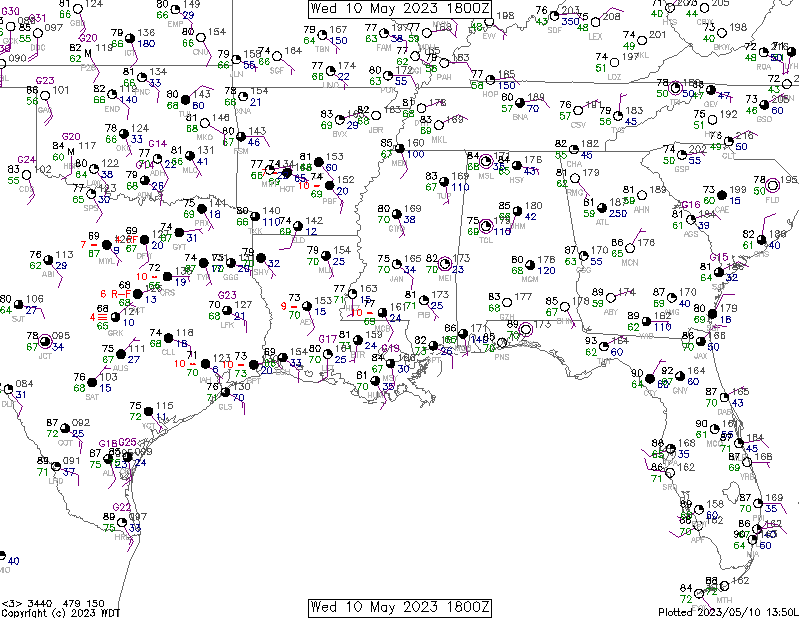
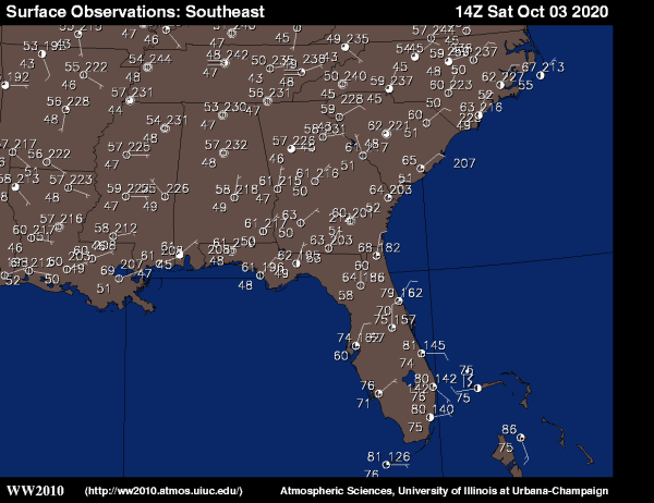
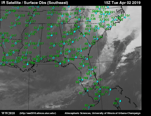
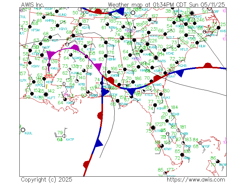
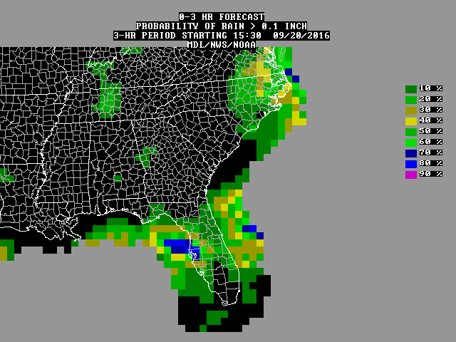