
JASON'S STORM CHASING WORLD
\chaser\chasedays\020521.html
| May 21th, 2002 - Day 6 |
UNDER CONSTRUCTION
Pictures are on top, with the log just below. Mesoscale discussions, Watches and Warnings, as well as a Preliminary Damage Report are located at the very bottom (added as available, and time permits for me to add them.
| At 4:13pm MST - Looking North at bowed shelf cloud. 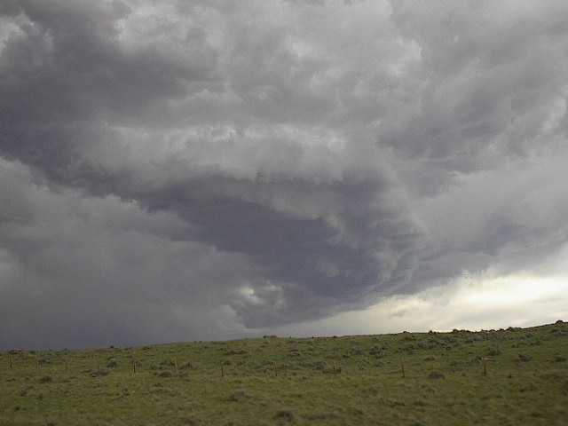 |
At around 6:13pm MST - Gust-nado (unknown direction) 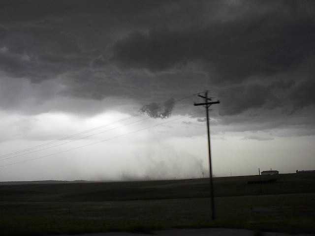 |
| At 2:30pm MST, flying Cow Spotted along I-25.  |
Looking east at the Rocky Mountains at 2:00pm MST 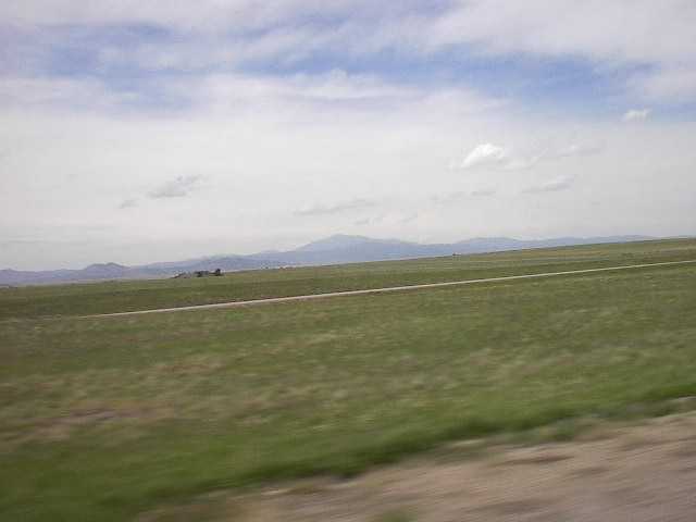 |
| GALLERY OF ALL PHOTOGRAPHS OF THIS DAY | |
| Tornado? | Hail? | High Winds? | Bust? | No Chase! | Other comment: |
| see log |
Log for Tuesday, May 21st, 2002
Waking up in Wyoming was quite a throw for me....I still can't believe we drove into Wyoming. Weathervine, Scott Blair, and later Eric Nygen joined up at the Rodeo Inn, our departure for Tuesday Morning. Target area was sketchy, and conditions were weak, nonetheless we headed north and west. We pretty much stayed to I-25, at about 2pm Mountain Time we saw the first cumulus clouds start to convect. Within 30 minutes there was distinct development and we had a defined target area. From incoming Outcasts, things were still weak with only slight possibility of severe weather. The best thing we had in our favor was the wind (strength and sheer). The main problem was the moisture wasn't in place...the Southeast winds were not pulling in enough off the gulf. Once the towers turned into well developed systems we traveled as far as Glenrock, Wyoming on I-25. Along the way we did see a decent shelf cloud, slightly bowed and slow clockwise (anti-cyclonic) motion. There was a few good CG's on the backside of the shelf cloud that made for some good photos. We turned around and started east again, to try to get ahead of the cool air, which had blown in while we were at Glenrock. The system was getting mushy by 5:0pm MT and we turned off I-25 onto US 26 eastbound. Around 6:30pm the three chase vehicles were traveling on US 26, watching the dust really kick up. We saw a few small vorticies in the dust, but nothing significant. Then on a down hill, we saw a large plum of dust overtaking the highway. Eric had pulled over and Scott was in the middle of overtaking a tracker trailer (which was moving slowly), with weathervine pulling up the rear (as usual). The plum quickly raced across the highway, as it did all three of us stopped and looked and saw plenty of rotation. "I see rotation", "Gustnado, Gustnado", it was intense...we were right in the middle of a small Gustnado with 74mph winds (as measured by Eric). What a feeling, to be in rotating winds that could classify as an F0 tornado...if it were a tornado. We had to spend a little time to get Eric's van untangled of Green netting which was blown across the road. (it's the green netting placed over new grass to stablize the seed, hay and soil).
Down the road we stopped in Torrington, Wyoming (just shy of the border to NE) to eat. Of course since we were with Eric, so our choices were Pizza Hut, Pizza Hut, and Pizza Hut. At the pizza Hut some other Chasers like Kris's group, and Blake. We finally departed after about one and a half hours of eating, talking, and confusing the waitress.
The day was pretty much over with little more than a gustnado under our belts. There are a few interesting shots as you see above. Now we are heading to North Platte, NE to stay, and set-up for a better day tomorrow.
SPC MESOSCALE DISCUSSION and NWS WARNINGS
PRELIMINARY LOCAL STORM REPORT
Storm Prediction Center:
| DAY#1 |
| DAY#2 |
| DAY#3 |
| DAY#4 |
| DAY#5 |
| DAY#6 |
| DAY#7 |
| DAY#8 |
| DAY#9 |
| DAY#10 |
| DAY#11 |
| DAY#12 |
| DAY#13 |
If you'd like to email me, please mail me at this address:
mrsuprcell@aol.com
Introduction,
Partners,
Checklists, Cost Overview, Chase Logs,
Vehicle List,
Links, Pictures,
Weather,
Home